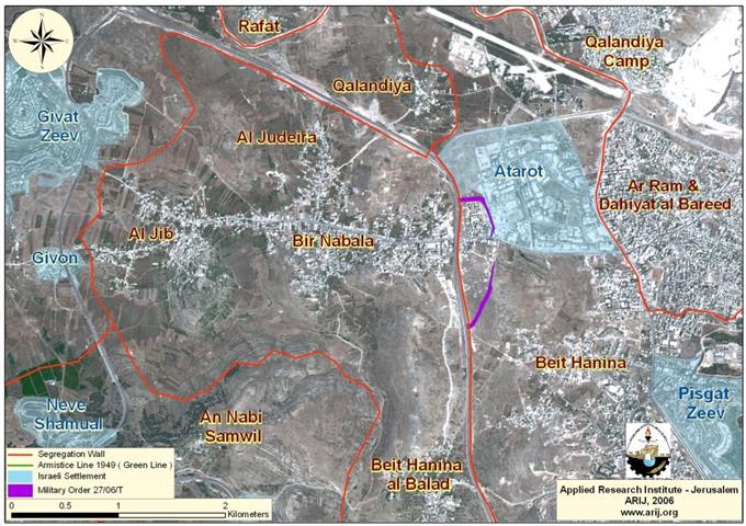
Bir Nabala village is located about 9 kilometers northwest of Jerusalem city. It has a population of 5,910 (the Palestinian Central Bureau of Statistics, 2005) and occupies a built up area of 1904 dunums. The built up area of Bir Nabala is correlated with the neighboring Palestinian villages of Al Jib and Al Judeira.
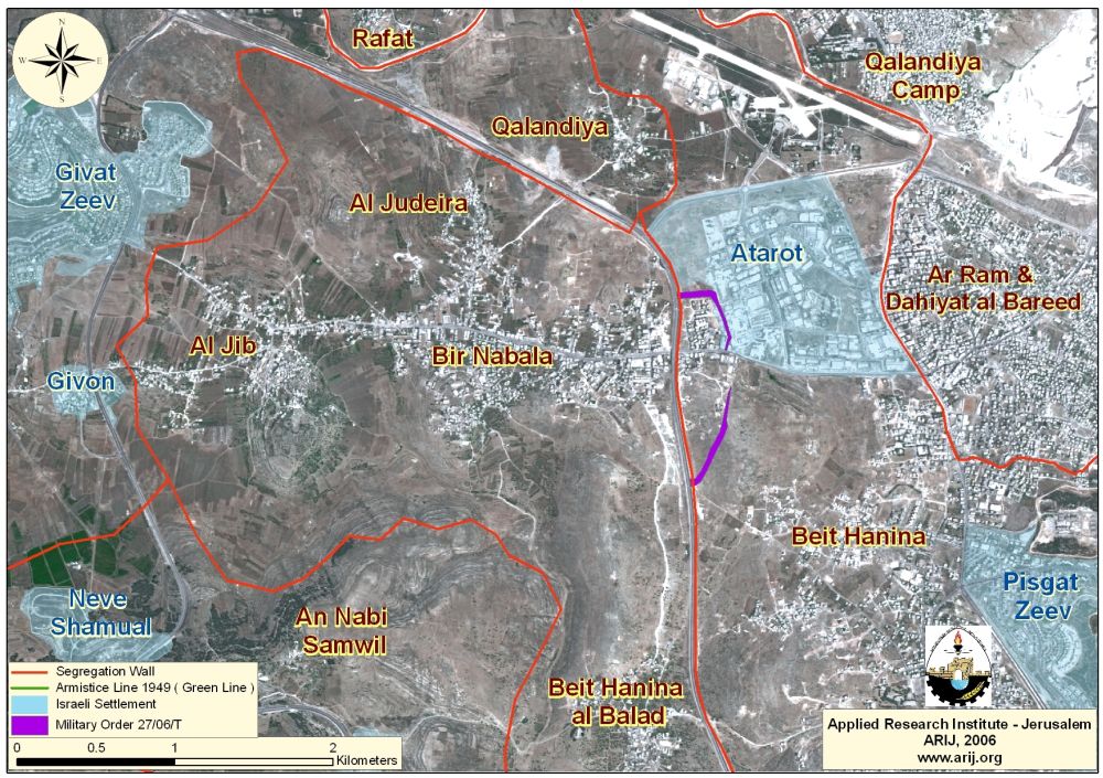
On February 20, 2006, the Israeli occupation forces (IOF) handed residents of Bir Nabala village a new military order holding number (27/06/T, Judea and Samaria, 2006), proclaiming the confiscation of an additional 41.3 dunums of Palestinian lands belonging to residents from Beit Hanina and Bir Nabala villages for the construction of the Segregation Wall. (See and read the translation of Military order no. 27/06/T in Annex I).
The section of the Segregation Wall designated in the Israeli military order will run a length of 2.71 km extending from the southeast to the northeast of Bir Nabala. The new altered section of the Segregation Wall will reunite two parts of Bir Nabala separated by the Segregation Wall into two separate enclaves. The new arrangements will place the entire 12,707 dunums, which constitutes Bir Nabala total area within a greater enclave, which includes beside Bir Nabala, Beit Hanina, Al Jib and Al Judeira.
Conclusion:
The Segregation Wall and International Laws:-
The Israeli Segregation Wall has to do with land grab more than it has to do with security. Annexing vast empty Palestinian land within the Segregation Wall constituted a primery target to the Israeli along with major Israeli settlements blocs holding some 85% of the Israeli settlers population in the West Bank. The Israel Segregation Wall violates a number of International Humanitarian laws, specifically The Hague Regulations of 1907 and the Fourth Geneva Convention of 1949, which state the following:
-
The Hague Regulations expressly forbids an occupying power 'to destroy or seize the enemy's property, unless such destruction or seizure be imperatively demanded by the necessities of war' (Article 23).
-
Article 53 of the Fourth Geneva Convention states that: 'any destruction by the Occupying Power of real or personal property belonging individually or collectively to private persons, or to the State, or to other public authorities, or to social or cooperative organizations, is prohibited, except where such destruction is rendered absolutely necessary by military operations.'
-
The appropriation and destruction of Palestinian land is an especially serious violation of the Fourth Geneva Convention, Article 147 of which clearly prohibits, ''extensive destruction and appropriation of property, not justified by military necessity and carried out unlawfully and wantonly.'' Violations of Articles of the Fourth Geneva Convention constitute grave breaches of the Convention and should be prosecuted as War Crimes.
Related Cases Studies
- Segregation Wall and gates dominate the landscape of the Palestinian Territory
' The case of Beir Nabala Enclave ' - Israelâ??s Segregation Wall Encircles Three Palestinian Villages in Northwest Jerusalem
Annex I
|
Israel Defense Forces Order to Seize lands n0 27/06/T
According to my authorities as a Military Chief Commander in the Region of Judea and Samaria, and as I believe that it is imperative for military reasons due to the special security situation in the region, I order the following: 1. The ''Map'' signed in scale 1: 20000 and attached to the order is an essential part of this order. The ''Lands'' : An area of land which is 41 dunums and 300 meters, marked in red in the map : Block 2: Parcel: 7, 8, 37, 39, 40, 43, 48-50, 56, 59, 85, 88, 90. Block 6: Parcel: 59, 60, 62, 67, 72, 89, 215, 235-230, 256, 257, 259. Block 12: Parcel: 283. Block 20: Parcel; 54, 55. Block 17: Parcel: 17, 16. Block 11: parcel: 158-162. 2. I announce by that the above mentioned lands are seized for military reasons 3. The IDF seize the lands and have an absolute control over it that is given to the officer of the central command officer of lands who is responsible in the ministry of defense. 4. These copies are to be given by the District Co-ordination Office ''The DCO'' of Jerusalem to the owners of land. 5. Copies are found with maps for those who are interested in the following places
6. The owners of land have the right to go to the DCO in Jerusalem in order to get more information about their right of land use expenses and compensation. 7. The Validity of this order starts at the date signed till 31/12/2008 8. The name of this order is: '' Order to seize lands n0 27/06/T (Judea & Samaria ) 2006 Yaeer Nafah
|
Prepared by
The Applied Research Institute – Jerusalem
ARIJ