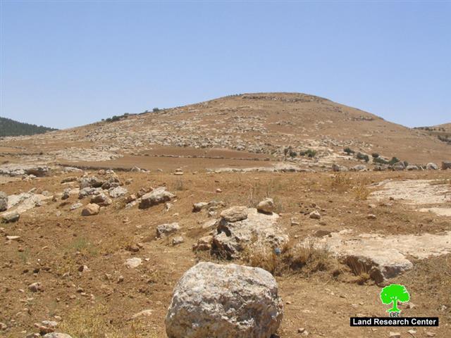
Photo 1: Khirbet Attuwani- Hebon: the Tel targeted for confiscation
The commander of the Israeli occupation forces (IOF) in the West Bank, general Ya'ir Golan, issued on July 3rd, 2006, a military decree stating the confiscation of 25 dunums of land for military purposes. The target land is owned by the families of Abu Sabha, Abu 'Ilian and Al Mansi from Yata town. It is located at the northern edge of the colonial bypass road number 317 between the Palestinian villages of Al Karmel and Atuwani south of Yata. The target land is a strategic hill top on which the Israeli army intends to establish a military base to overlook the whole area.
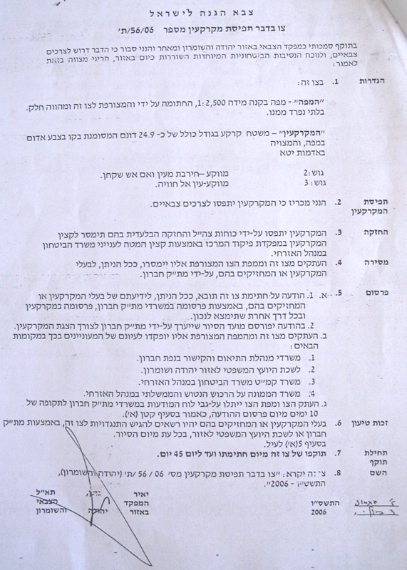
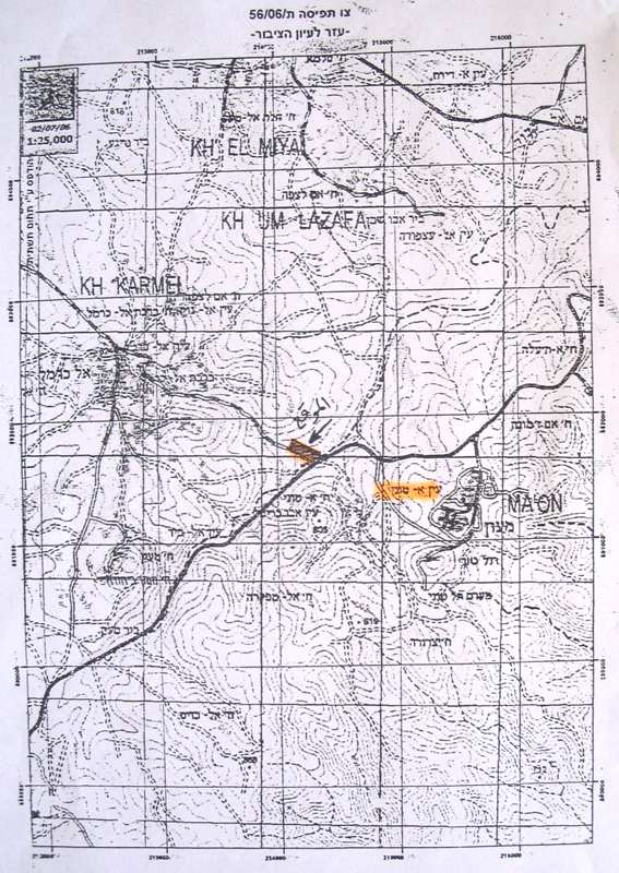
Photos 2 & 3: copies of the military decree)
Khirbet Atuwani
Located on the southern side of road number 317 close to Ma'on settlement (see the attached map). It has a total population of 350 citizens, mostly farmers and sheep breeder. It's total land area is 2758 dunums of which 44.6 dunums are built up area. See Map 1
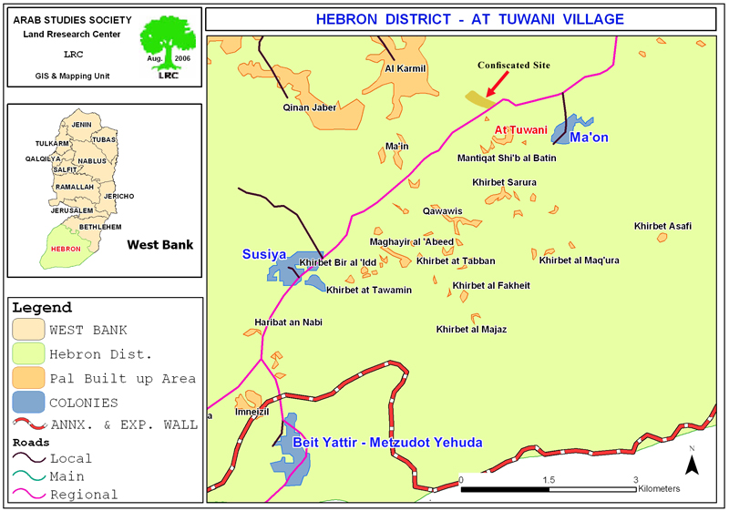
Impact of latest violation on Atuwani
Atuwani is the only remaining passage way from Yata to Bir Shiva' region for the crossing of workers, merchants and goods after the closure of Ar Ramadin's and Khirbet Imneizel's crossings by the construction of the Annexation and Expansion Wall respectively in the south west and south of the district.
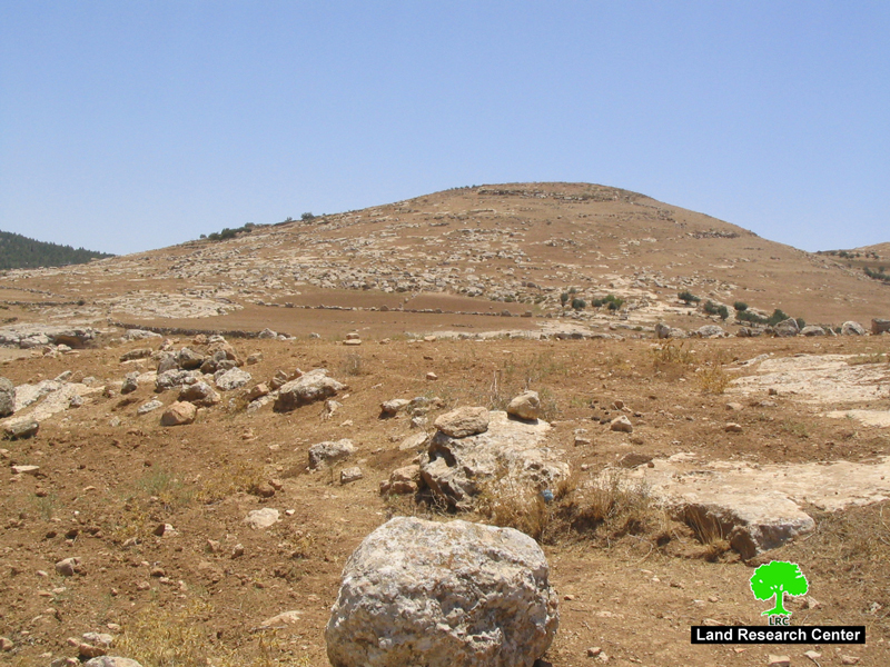
The Atuwani area is, also, a main gate for the daily crossing of sheep and goat herds into the eastern slope's range land which constitute 80% of Yata range land. See Photo 4

Local sources put the actual land area which will be affected by the establishment of the military base at 1000 dunums, of which 120 dunums are immediately located near the target Tel, while the remaining area will become difficult to access. These 1000 dunums are owned by the Yata families of Al Makhamra, Shawahin, Nawaj'a and Shamti.
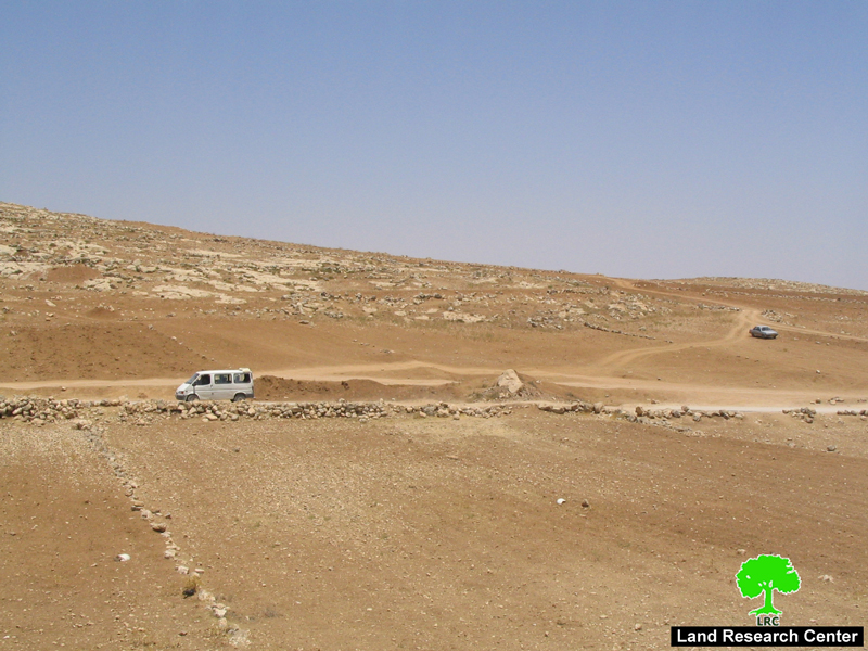
Photo 5: Khirbet Attuwani: at the bottom of the targeted Tel is the only road to attuwani;
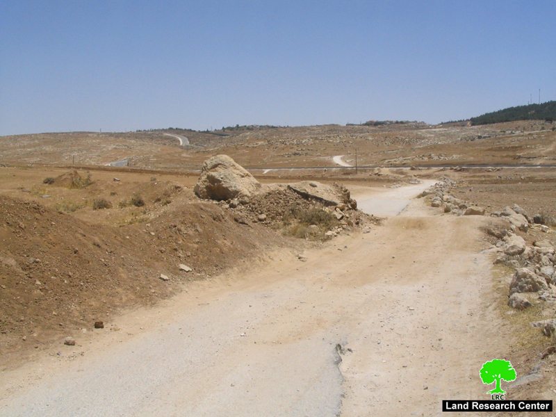
Photo 6: In the background is bypass road number 317
Road barrier
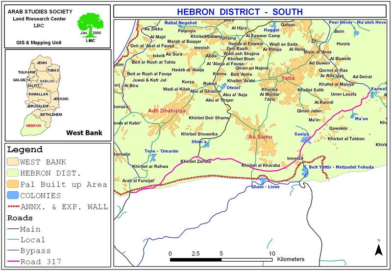
Atuwani is only one of 22 Palestinian communities with a total population of about 2000 who are now besieged between two barriers � the Wall barrier in the south and road barrier in the north. That is, the Israeli occupation authorities in December last year decided to build a road barrier along road number 317 which runs from the settlements of Karmel to that of Tene in south Hebron at the length of 13 km. This road barrier is to secure the movement of Jewish settlers driving along the bypass road by restricting Palestinian vehicular access onto them. This measure directly benefits the nearly 3000 settlers living in the belt of colonies and outposts connected by this road and all those intending to reach southern Israel. See Map 2
Construction of this secondary inner Wall � road barrier- started at the beginning of this year. It involved the construction of a continuous barrier of concrete running along the northern side of the bypass roads 317. Built within three to four meters of the edge of the road, the barrier is 80cm to 1m high to prevent vehicles from crossing onto the main road (see attached photos).
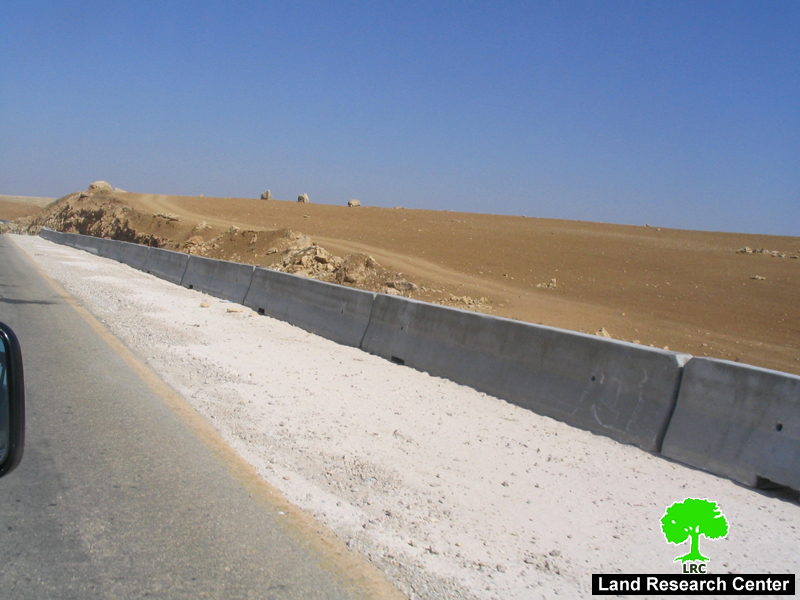
(Photo 7: cement road barrier on road number 317)
The route of the �road barrier� roughly follows the same direction of the 2003 plan for the Wall, but, it, also, represents the last in the long list of closures cumulatively applied to roads 317, 60 and 325 to prevent access of Palestinians. In 2003, the Israeli Ministry of Defense published plans for the route of the Annexation and Expansion Wall keeping the belt of Jewish colonies in the south Hebron on the southern side of the fence, served by roads 60 and 317, safely connecting them to Israel. See Map 3

The route was eventually revised on February 20th, 2005 pushing the Wall to the Green Line, albeit with a couple of 'bubbles' where it veered back into the West Bank to incorporate the colonies of Metsadot Yehuda (Beit Yatir) and Eshkolot.
Israeli colonies in the area
The following is a list of Israeli colonies located on road number 317 which will benefit from this arrangement:
|
Colony name |
Date of establishment |
Population in 2003 |
|
Karmel |
1981 |
321 |
|
Ma'on |
1981 |
327 |
|
Susiya |
1983 |
643 |
|
Mezadot Yehuda ( Beit Yattir) |
1980 |
412 |
|
Shani |
1989 |
438 |
|
Total |
|
2141 |
Source: Foundation for Middle East Peace
Access and closure in south Hebron
Since October 2000, the IOF has progressively sealed off south Hebron, managing to disconnect resident Palestinians from urban areas further north through a combination of physical obstacles (road blocks, earth mounds and checkpoints) and the imposition of movement restrictions along roads 317 and 60 to Palestinian travel. Today, all exits to Palestinian villages along these two roads are blocked: no direct paved access is available to towns such as Ad Dhahiriya, Yatta and As Samu�.
These restrictions have been put in place to benefit and secure the movement of Jewish settlers residing in the Governorate, allowing them to move safely between settlements and further on to Israel without crossing a Palestinian area. Roads 317, 60 and 325 (see attached map) broke up the transportation contiguity between Palestinian controlled areas and forced Palestinians onto internal secondary roads and fragment the territorial contiguity of the Governorate. The result is particularly dramatic in south Hebron where communities do not have the option of moving on internal secondary roads and have to cross bypass roads to access services and markets, breaching the security regime imposed by the IOF.
Although the details of the extent to which the IOF will facilitate the movement across road 317 for local Palestinian communities and owners of land are not available, the road barrier will entrench further the disconnection already evident on the ground, possibly leading to complete isolation and the likelihood of displacement and loss of land.
Impact of the road barrier on Palestinians
The livelihood of these communities is based on a combination of shepherdinginvolving the rearing of animals for sale as meat, and the sale of dairy products like cheese and yogurt. These products were traditionally transported and sold in Yatta and the Old Suq of Hebron. In addition, dry-land farming � entailing the rain-fed cultivation of grains, pulses, fodder and olives� and smaller scale cultivation of vegetables and tobacco for community consumption are central to livelihoods.
Access to land
Many of the shepherds living south of roads 317 and 60 own land on its northern sides and currently simply walk across them to reach grazing areas. A road Barrier will cause in the best case a long detour for the shepherds who will have to find the nearest gate, hoping for it to be open. In the worst case it will represent an obstacle impossible for the animals to cross. It is estimated that there are about 24,730 heads of livestock in south Hebron, a percentage of which will need to cross the road to access grazing areas on the other side. In addition another 8,500 heads travel south every year during the seasonal migration to the area.
Table 1
Land ownership south of �road barrier�
|
Municipality where land is registered |
Number of Palestinian owners** |
Amount of land owned (dunum)** |
|
Yatta |
1,537 |
63,780 |
|
As Samu� |
966 |
21,997 |
|
Adh Dhahiriya |
939 |
6,300 |
|
Total |
|
92077 |
**Source: Land Registration Authority (Yatta, As Samu� and Adh Dhahiriya)
Palestinian owners of land who do not reside in the area stand out as another group potentially affected by the establishment of the �road barrier�. According to the records of the Land Registration Authority in the municipalities of Yatta, As Samu� and Adh Dhahiriya, there are almost 3,500 families whose land holdings in the area would be affected. However, as land registration was carried out by clan (�Hamula�) under Jordanian rule, the numbers do not reflect current levels of ownership as plots of land have been divided among subsequent generations. The Municipality of Yatta recommends multiplying the overall figure by 20 to get a closer approximation to the current number of Palestinian owners.
(Insert photo 8: Khirbet Attuwani: olive field damaged by Israeli settlers from Maon last April)
Access to services
Tasked with reaching more than half a million people in the Governorate, the local directorates of Health, Education and Social Affairs have struggled to extend the reach of the Palestinian Authority (PA) to these area. The decentralization of institutions implemented to cope with the fragmentation of the West Bank that followed the imposition of closures was unsuccessful in south Hebron. More problematically, the designation of most of the land as �area C� under the Oslo Accords has prevented the PA from developing any infrastructure at the local level to support these communities; the structures that have been built have all received demolition orders and some have already been demolished.
Currently, available basic services are minimal and most are out of the area, to be reached only by crossing roads 317 and 60. Secondary level education institutions are present in Al Karmil, Yatta, and As Samu�. The majority of teachers serving in the two schools south of road 317 (located in At Tuwani and Imneizel) are non-resident and are often prevented from reaching the institutions by IOF permanent and flying checkpoints along the bypass road. Already in 2004, the Directorate of Education in Hebron stated that the poor conditions in the area have resulted in lower attendance records and high drop out rates since the beginning of the Intifada compared with the rest of the Governorate.
None of the existing health facilities are operational. The clinics in At Tuwani and Imneizel have received several demolition orders by the IOF. The Ministry of Health relies on international funding and NGOs to reach these communities with primary healthcare mobile clinics. Ambulances cannot reach patients in the south of Hebron without a detour of several kilometers. Families of patients prefer instead to reach the nearest earth mound or gate the emergency services can reach and transfer the patient across (back-to-back).
Access to markets
Residents of the communities south of 317 and 60 are dependent on the markets of Adh Dhahiriya, As Samu�, Al Karmil and Yatta. In the past, shepherds used to sell dairy and meat products to the Old Suq in Hebron, but the restrictions on movement and the difficulty in reaching the Governorate capital shifted the hub of trade and commerce to the south. Today, even reaching these local markets is problematic as crossing road 317 and 60 is not permitted by the IOF after building the roads barrier. To cope with this, merchants from the north have started to travel to these communities to overcome the unpredictable supply. Overall, however, the connection between the producers in rural areas and the sellers on the markets is deteriorating.
Markets to the north of road 317 provide many of the goods required by the communities in south Hebron, such as fodder for the animals, as well as water, clothes and food for their families. Traveling to the markets becomes crucial when fodder and water for the livestock run out; by the end of spring the land becomes arid again and there isn�t much grass to graze on for the animals while the rain-fed cisterns dry up by July. Clearly, with additional restrictions imposed on movement to the north, the ability to secure vital inputs and to derive an income to sustain their livelihood will reduce further.
Access to water
In addition to suffering from district-wide capacity and allocation constraints, the south of Hebron is poorly served by existing water networks. The Palestinian Water Authority plans to extend the regional network to the area south of As Samu� and Yatta but the implementation is likely to take several years more. A large percentage of the rural communities rely on water trucking, particularly once summer begins and the rain-fed cisterns start emptying. As no filling points exist south of road 317 except further east, in the Bedouin communities of An Najada and Hameeda, water has to be brought in from Yatta where tankers are bought from either the Joint Services Committee or the Municipality.
Social networks
Almost all of those living in these communities are herders, traditionally sedentary and distinct from nearby Bedouin populations. Social connections and family ties with the urban areas of Yatta, As Samuâ�� and Adh Dhahiriya are very strong. Most of the communities in southern Hebron moved from those towns in the early decades of the 19th century when pressure on existing land reserves prompted outward migration toward the edges of the Hebron mountain range – an area that enjoys significant rainfall in winter.
A road barrier would isolate them from their extended families, who would be discouraged from visiting the area. The separation would stifle the social linkages at the basis of these people�s 'fabric of life'.
Table 2
Palestinian communities south of 'road barrier'
|
|
Palestinian communities
|
Population statistics |
|
1 |
Saadet Tha�lah |
100* |
|
2 |
Khallet Athaba |
30 |
|
3 |
Isfey Foqa |
109 |
|
4 |
Isfey Tihta |
81 |
|
5 |
Maghayir al Abeed |
47 |
|
6 |
Tuba |
78 |
|
7 |
Al Fakheit |
68 |
|
8 |
At Tabban |
95 |
|
9 |
Al Majaz |
90 |
|
10 |
Halaweh |
52 |
|
11 |
Mirkez |
42 |
|
12 |
Jinba |
216 |
|
13 |
Mantiqat Shi�b al Batin |
144 |
|
14 |
Qawawis |
37 |
|
15 |
At Tuwani |
350 |
|
16 |
Imneizil |
193 |
|
17 |
Al Kharaba |
2 |
|
18 |
Haribat An Nabi |
50 |
|
19 |
Ghuwein Al Foqa |
44 |
|
20 |
Khirbet Zanuta |
50 |
|
21 |
Ratheem |
18 |
|
22 |
Wadi Al Khalil |
70 |
|
|
TOTAL |
1,896 |
*Source: Environmental Resources Management � estimate based on
project planning and implementation 2001-2004.
Prepared by
The Land Research Center
LRC


