Archive

Back to homepage
Separation Plans

ARIJ Fact Sheet
Israel’s Segregation Wall: Isolation and Ghettoization in the Holy Land

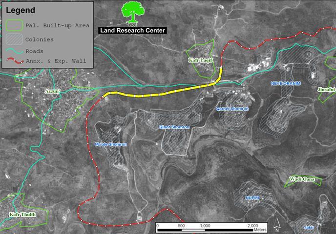
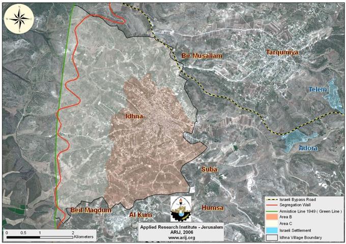
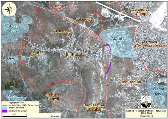
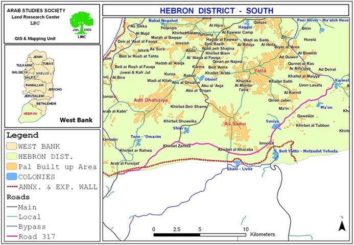
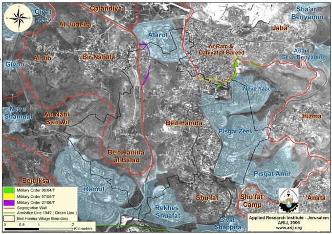
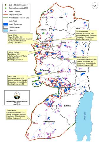
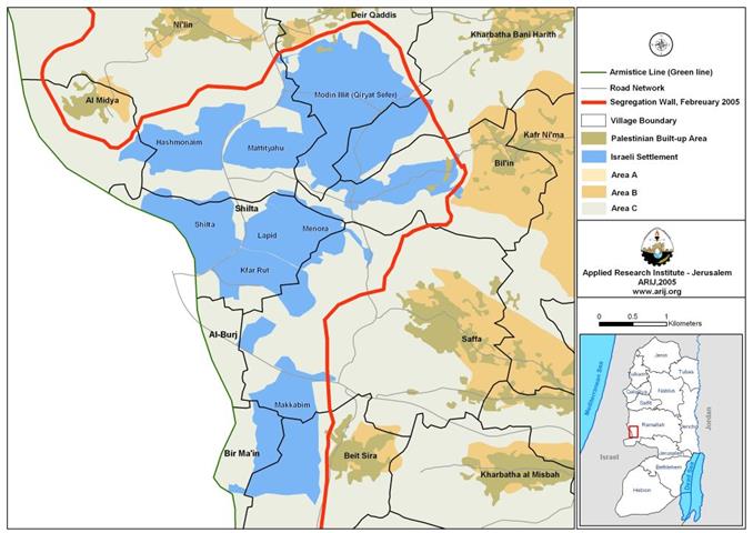
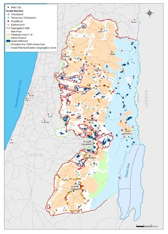
On February 20, 2005 the Israeli government approved a revised plan for the Segregation Wall in the West Bank.  The new wall plan makes some small cosmetic changes in the

Separation Plans

In challenge of High Court decision Resumption of Wall works around the settlement of Karmei Zur

(Photo 1: Israeli bulldozers work in Palestinian land near Karmei Zur settlement)   On Thursday August 24th, 2006, Israeli bulldozers resumed works in the construction of the Segregation Wall around

Reports

Settlers of Itamar still fighting to maintain illegal outposts

The illegal settlement of Itamar lies two kilometers south of Balata and Askar refugee camps on the outskirts of Nablus city. Itamar was established in 1984 as a religious settlement

Military Orders

Land confiscated for settlement protection Qarut and Jalud Villages

The Israeli occupation forcers (IOF) issued a military decree stating the confiscation of at least 200 square meters from the lands of the villages of Qarut and Jalud, Nablus governorate,

Agriculture

Land shaving at the eastern side of the Segregation Wall

The Israeli occupation forces (IOF) distributed dozens of written notices stipulating the uprooting of hundreds of olive and almond trees in the eastern bank of the Segregation Wall path in

Confiscation

Land confiscated for military base and permanent checkpoint in Kafr Laqif

The Israeli occupation forces decided to confiscate 8 dunums of land from Kafr Laqif and Hajja village/ Qalqiliya governorate for the purpose of establishing a military base and permanent checkpoint

Separation Plans

Resumption of Wall construction in the biggest finger-like corridor in the West Bank

(Photo 1: the yellow section of the Wall currently under construction)   The Israeli army bulldozers resumed works in the construction of the Annexation and Expansion Wall in the lands of

Reports

Idhna Village, clammed by the Israeli Segregation Wall

Background Idhna is a small village located some 12 km northwest of Hebron city, at the southern part of the West Bank. The 20001 dunums village rises 400-500 meters above

Reports

Bir Nabala Village: two Separate Enclves reunited into one Big Enclave

Bir Nabala village is located about 9 kilometers northwest of Jerusalem city. It has a population of 5,910 (the Palestinian Central Bureau of Statistics, 2005) and occupies a built up

Confiscation

Road barrier: another Israeli tool for land confiscation

'Road barrier' is the latest Israeli tool for land confiscation in the West Bank. According to the Israeli army's published series of Wall maps and revised Wall maps, all the

Military Orders

25 dunums seized from Khirbet Atuwani for the construction of a military camp

Photo 1: Khirbet Attuwani- Hebon: the Tel targeted for confiscation   The commander of the Israeli occupation forces (IOF) in the West Bank, general Ya'ir Golan, issued on July 3rd,

Reports

The Massive Israeli Operations Against the Gaza Strip

The Gaza Strip has been going through harsh aggressive measures since June 25, 2006, when the Israeli forces launched the Summer Rains operation that followed a military operation led by

Settlement Expansion

New Expansions in the Israeli West Bank Settlements

It was published on Haaretz daily newspaper on the 22ed of May 2006 that the Israeli Defense Minister Amir Peretz has approved the decision made by his predecessor Defense Minister

Reports

Lands of Beit Hanina (Al-Balad) village threatened by the Israeli Segregation Wall

Introduction: Beit Hanina; is a small Palestinian village located approximately 5 kilometers north of Jerusalem city. The village has a mountainous topography with an elevation of 601-800 meters above the

Reports

Uncertain Probability, Will Israel Ever Evacuate the Settlements’ Outposts ??

Overview In March 2005, the Israeli government attorney Talia Sason submitted a report on the status of established Israeli outposts in the occupied West Bank territory upon the request of

Israeli Plans

New Israeli Unilateral Plans in the Old City Aiming to the Judaization of Jerusalem

Introduction Since East Jerusalem was annexed in 1967, Israel aimed to alter the demographic and geographic realities to its favor to emphasize its sovereignty over the city. To achieve this

Reports

Impact of Wall inception on the border villages of Dura region

Photo 1: Deir Samit village: A Palestinian farmer standing in his olive orchards destroyed by the Wall)     An introduction to the study area: This study covers the Wall

Settlers Attacks

Separated Palestinain lands set into fire at the hands of Israeli settlers from Sha’are Tikva and Elkana settlements

Photo 1: olive fields burnt by settlers in Az Zawiya   Dozens of settlers from the settlements of Sha'are Tikva and Elkana set fire to about 1000 dunum of olive

Settlement Expansion

New settlement constructions at Modi’in Illit settlement Bloc.

Location; The Modi'in Block is a group of Israeli-Jewish settlements located approximately 8 Km northwest of Jerusalem along the 1949 Armistice Line. The block contains 8 settlements listed in the

Reports

42 Palestinian Localities in the Eastern Segregation Zone are under daily Israeli aggression

Background: The eastern part of the West Bank includes the Jordan Valley and the upper part of the Dead Sea western shores and occupies an area of 1664 Km2. The