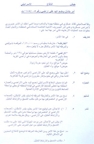
The Israeli occupation forces started the construction of a separation barrier around the settlement of Tene (Ma'ale Omarim) to the south of the city of Hebron. A military decree carrying the number of T/185/05 was issued last year; however, it was distributed to land owners only at the beginning of July, 2006 stating the confiscation of 138 dunums located in basin number 3 and 4 of Adh Dhahiriya town's land for the purpose of establishing what the decree called a 'protective barrier' in the western side of Tene settlement (see attached copy and map of the military decree).
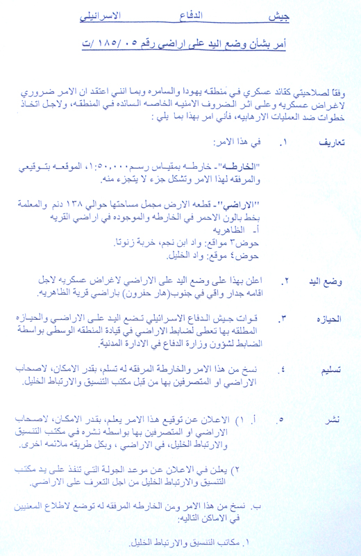
(Photo 1: copy of the military decree)
Introduction to Tene settlement
It was established in the year 1983 over lands confiscated from Adh Dhahiriya and As Samu' towns. Its population toll reached 538 settlers by the end of 2004. The total built up area of the settlement is 272 dunums, while the municipal area is 8269 (source- Foundation for Middle East Peace- Washington).
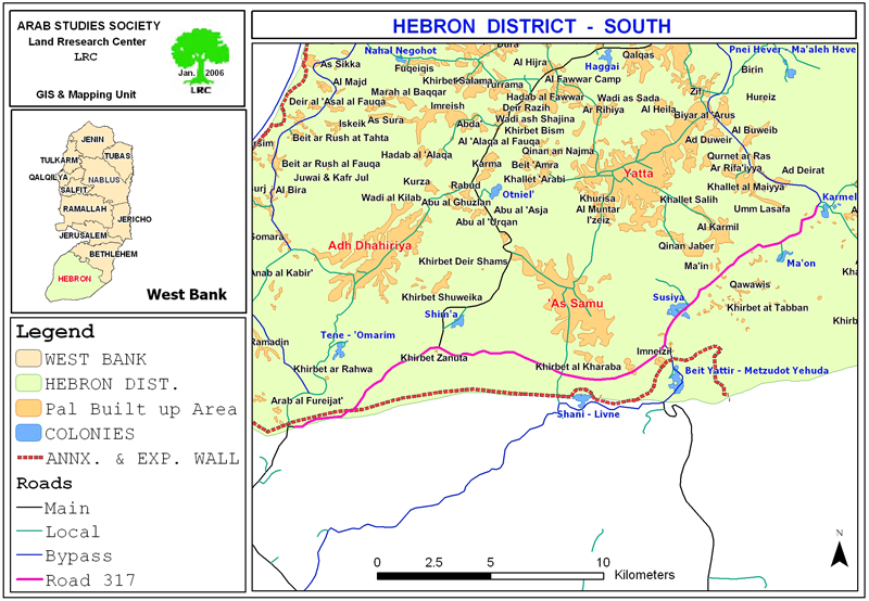
Map 1: location of Adh Dhahiriya and Tene settlement)
Land seizure under security claims
In an interview with LRC field worker, the head of Adh Dhahiriya municipality, Mr. Sami Ishneiwer, pointed out that the 138 dunums mentioned in the above military decree relate only to the strip of land which will be devastated under the path of the barrier. But, there is no mention to the hundreds of dunums expected to be separated behind it and which will be inaccessible for legitimate owners. The target lands belong to the families of Al Batat, Al Makharza, Abu Alan and Hawarin.
Mr. Ishneiwer went on to say that since the occupation of 1967, the Israeli occupation authorities have seized about 167 000 dunums of lands of which 20 000 dunums are agricultural fields, in addition to thousands of dunums of rangeland. He reiterated that the Israeli occupation authorities are using the same pretext of 'security' as a cover to seize more area of Palestinian owned land.
The land owners whom LRC field worker met confirmed that they already faced a quite many obstacles in reaching their agricultural fields near the settlement of Tene because of the existing military barriers, road blocks and bypass roads. The inception of the so-called 'preventive barrier' around the settlement will further complicate matters for them and add more obstacles on the way to their lands and sources of livelihood.
Wall works in Adh Dhahiriya
As regards the Annexation and Expansion Wall, the Israeli occupation forces issued last year two military decrees stating the confiscation of about 1000 dunums for the construction of the path of the Wall to the west and south of the town. Along with this number thousands of extra dunums were also separated behind the Wall. The first decree carried the number of T/02/05 stipulating the confiscation of 110 dunums, and the second carried the number of T/05/71 stipulating the confiscation of 689.9 dunums (see attached copies and maps).
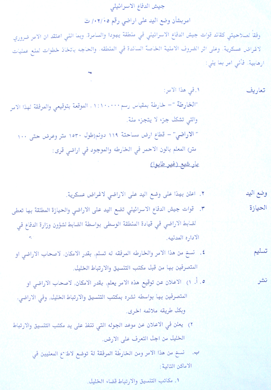
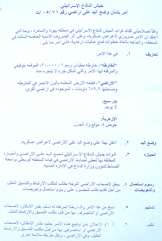
(Photos 2 & 3: copies of military decrees)
Table 1: Land confiscation and separation for Wall construction in Adh
Dhahiriya town by name of owner, No. of family members, No. of children and No. of dunums
|
No. |
Owner's name |
No. of family member |
Children under 18 |
No. of dunums |
|
1 |
Mohammed Bader Abu Allan |
5 |
2 |
25 |
|
2 |
Husam Bader Abu Allan |
5 |
3 |
25 |
|
3 |
Wajieh Nayef Abu Allan |
8 |
3 |
14 |
|
4 |
Hamd Hasan Abu Allan |
8 |
0 |
10 |
|
5 |
Odeh Mohammed Makharza |
7 |
0 |
13 |
|
6 |
Mahmud Hasan Abu Dabur |
8 |
6 |
40 |
|
7 |
Kamel Mustafa At Til |
9 |
7 |
15 |
|
8 |
Taleb Ali Iwridat |
10 |
6 |
12 |
|
9 |
Badi'h Shaker At Til |
4 |
2 |
20 |
|
10 |
Ibrahim Badi'h At Til |
7 |
5 |
15 |
|
11 |
Izzat Hasan Abu Dabur |
11 |
9 |
45 |
|
12 |
Isma'il Mohammed Iwridat |
10 |
8 |
13 |
|
13 |
Ali Khalil Iwridat |
11 |
9 |
19 |
|
14 |
Sharif Mohammed Iwridat |
20 |
0 |
15 |
|
15 |
Isa Mohammed Abu Allan |
11 |
8 |
14 |
|
16 |
Tawfiq Mohammed At Til |
9 |
7 |
15 |
|
17 |
Atiya Mohammed Al Jabarin |
3 |
0 |
9 |
|
18 |
Ibrahim Mutlaq Al Jabarin |
9 |
1 |
10 |
|
19 |
Khalid Abdul Fattah Abu Allan |
2 |
0 |
20 |
|
20 |
Ratib Ahmad Shurukh |
8 |
3 |
15 |
|
21 |
Ibrahim Mohammed Al Qaysiya |
2 |
0 |
20 |
|
22 |
Mahmud Abdul Fattah Abu Allan |
16 |
2 |
12.5 |
|
23 |
Khalil Abdul Fattah Abu Allan |
10 |
8 |
12.5 |
|
24 |
Sa'ud Mohammed Abu Allan |
7 |
4 |
10 |
|
25 |
Omer Hija Abu Allan |
4 |
2 |
12 |
|
26 |
Mahmud Mohammed Abu Allan |
8 |
6 |
59 |
|
27 |
Khalil Hija Abu Allan |
5 |
3 |
50 |
|
28 |
Ahmad Hija Abu Allan |
2 |
0 |
100 |
|
29 |
Mohammed Musa Abu Allan |
15 |
0 |
15 |
|
30 |
Abdullah Mahmud Abu Allan |
5 |
3 |
12 |
|
31 |
Isam'il Hija Abu Allan |
2 |
0 |
17 |
|
32 |
Isma'il Ahmad Abu Allan |
11 |
4 |
22 |
|
33 |
Mohammed Ali Dayyeh |
7 |
0 |
10 |
|
34 |
Ali Mohammed Abu Dabur |
9 |
6 |
2 |
|
35 |
Ibrahim Mahmud Abu Dabur |
10 |
6 |
3 |
|
36 |
Mohammed Omer At Til |
10 |
3 |
10 |
|
37 |
Mohammed Mahmud Abu Allan |
NA |
NA |
15 |
|
38 |
Khalid Abdul Fattah Abu Allan |
NA |
NA |
30 |
|
39 |
Omer Jafal Az zagharin |
NA |
NA |
7 |
|
40 |
Jafal Salim Az Zagharin |
NA |
NA |
5 |
|
41 |
Hussein Salim Az Zagharin |
NA |
NA |
15 |
|
42 |
Hasan Salim Az Zagharin |
NA |
NA |
7 |
|
43 |
Salim Salman Az Zagharin |
NA |
NA |
25 |
|
44 |
Ibrahim Salman Az Zagharin |
NA |
NA |
25 |
|
45 |
Mohammed Abed Abu Allan |
NA |
NA |
50 |
|
46 |
Abdul Razaq Khalil Ifreijat |
NA |
NA |
7 |
|
47 |
Mahmud Abdul Aziz Al Jabarin |
NA |
NA |
15 |
|
48 |
Ghazi Mahmud Asamasra |
NA |
NA |
20 |
|
49 |
Jamil Ibrahim At Til |
NA |
NA |
10 |
|
50 |
Mohammed Salman Az Zagharneh |
NA |
NA |
105 |
|
51 |
Odeh Badwai Al Makharza |
NA |
NA |
10 |
|
52 |
Abdul Aziz Ahamd Al Makharza |
NA |
NA |
7 |
|
Total |
288 |
126 |
1265 |
|
Source: Adh Dhahiriya municipality.
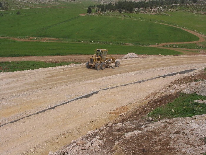

Photos 4 & 5: Wall works to the west of Adh Dhahiriya)
Photos courtesy of LRC
Prepared by
The Land Research Center
LRC