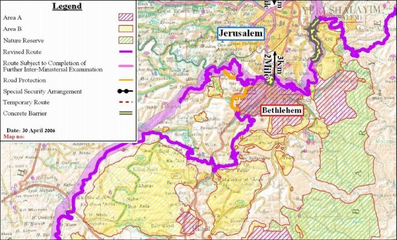
On April 30th, 2006 the Israeli Ministry of Defense issued on its website an updated Wall plan indicating major changes in a number of locations which constituted major obstacles in the construction of the Segregation Wall according to the Israeli Ministry.
The modifications included changes in the Wall’s route in the Ariel settlement bloc, in Salfit, Al Jab'a village, southwest of Bethlehem, Al Walajeh Village northwest of Bethlehem, the Jerusalem Envelope (to speed up the closure of Wall gaps in the Segregation Wall around Jerusalem city and overcome the legal cases that are pending at the Israeli high court by Palestinian Village councils who are objecting the route of the Wall around Jerusalem City) and Beit Iksa village, northwest Jerusalem city.
Israeli Old Wall plan in Al Walajeh Village
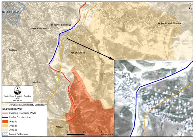
According to the revised Wall map of February 20, 2005 which was published on the Israeli Ministry of Defense website, the village of Al Walajeh will lose almost half of its lands for the construction of the Segregation Wall. The analysis of the Geographical information system at the Applied Research Institute – Jerusalem showed that the Wall (according to February 20, 2005 map) will seal off Al Walajeh village (which has a total area of 4403 dunums area) from three directions, east, west and north where a total of 1600 dunums of lands; which constitute 36% of the village lands; will be segregated behind the Wall (north and west of the Wall) including part of 'Ein Al Juweza Neighborhood; while the remaining 2804 dunums of Al-Walajeh village lands will fall within the enclave created by the Segregation Wall under Israeli jurisdiction but on the Palestinian side of the 1949 Armistice Line. As for the southern part of Al Walajeh village, it is already bordered by the Israeli bypass road number 436 (See Annex 2) whose path also confiscates about 0.5 km² of Al Walajeh village lands. ; while the remaining of Al-Walajeh village lands will fall within the enclave created by the Segregation Wall under Israeli jurisdiction but on the Palestinian side of the 1949 Armistice Line. As for the southern part of Al Walajeh village, it is already bordered by the Israeli bypass road number () whose path also confiscates about 0.5 km² of Al Walajeh village lands.
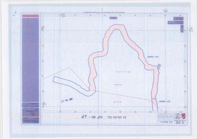
Military order number (67/06)
On April 27, 2006, the Israeli Ministry of Defense handed out residents of Beit Jala city and Al Walajeh village a new military order number (67/06) stating the confiscation of 317 dunums for the construction of a 3.8 km long Segregation Wall. Out of the total area declared for confiscation, a total of 291 dunums to be confiscated from Al Walajeh village. In addition, the military order showed a shift in the Wall route in Al Walajeh village from its northern part which included the neighborhood of 'Ein Al Juweza on the southern side of the Wall. This shift was an update to the February 20, 2005 Wall map which included part of 'Ein Al Juweza neighborhood north of the Wall. See copy of military order

The new Wall update
Later on April 30th, 2006, the Israeli Ministry of defense issued its updated Wall plan which indicated changes in the Wall route in Al Walajeh village including the changes that were stated in Military order(67/06) regarding the northern part of Al Walajeh village. In addition, the maps showed that the Wall will place Al Walajeh village in an isolated enclave, sealed off from all directions, east, west, north and south and separated from the neighboring Palestinian communities of Battir, Husan, Beit Jala and Bethlehem city center.
Source: Israeli Ministry of Defense Web Site
As for the southern part of Al Walajeh village, it will be sealed off completely by a 2.5 km long Wall that will run alongside bypass road number 436 (See Annex 1), and will be protected from both sides with barbed wires and ditches (ranging between 80 and 100 meters wide).The construction of the Wall and the road protection will cause the isolation of an additional 1100 dunums of lands from Al Walajeh village, where these lands will be inaccessible to Palestinian residents of the village. See Map 1
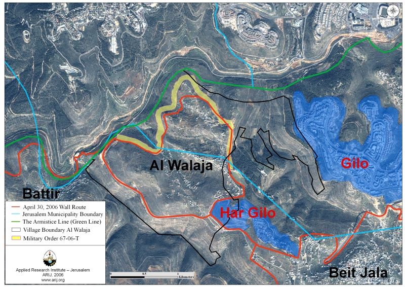
In Total, the Israeli segregation Wall plan will extend for 6 km on lands of Al Walajeh village, of which 3.5 km will be constructed as barbed wires. The Wall will isolate a total sum of 1980 dunums of the village's lands (including the 1100 dunums mentioned earlier); that is 45 % of the total village area.
Access to Al Walajeh Village
On February 9, 2006, the Israeli Occupation forces issued a new military order number (25/06/T) in Beit Jala city and Al Walajeh village to confiscate 39.8 dunums of land for the construction of a passage that will control the movement of residents into and out of the village.
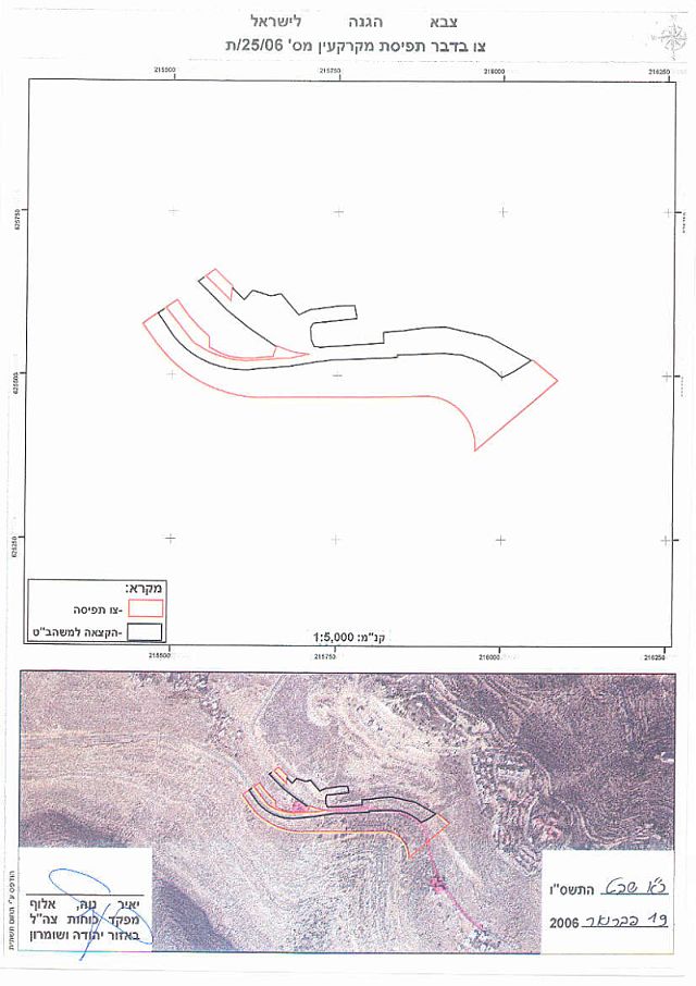
See Translation of military order in Annex 3
This passage is a complementary to the Segregation Wall plan which Israel plans to construct in Al Walajeh village as Passage in and out of the village will be restricted by this passage once the Wall is completely constructed.
Conclusion
The updated Israeli Wall plan negatively affects the village of Al Walajeh as it confiscates more of its land and deprives its residents from the open spaces they own. In addition, the enclaving of Al Walajeh village from all sides will separate it from the nearby Palestinian villages and deprive them their rights assigned to them by the international law and Human Rights laws such as the International Covenant on Civil and Political Rights and the International Covenant on Economical, Social, and Cultural Rights both of which Israel has signed.
-
The International Covenant on Civil and Political Rights (ICCPR) – Property (ICCPR, article 1): All peoples have the right of self-determination. By virtue of that right they freely determine their political status and freely pursue their economic, social and cultural development.
-
The International Covenant on Economic, Social and Cultural Rights (ICESCR) – health (ICESCR, article 12): The States Parties to the present Covenant recognize the right of everyone to the enjoyment of the highest attainable standard of physical and mental health.
-
The International Covenant on Economic, Social and Cultural Rights (ICESCR) – Education (ICESCR, art.13: The States Parties to the present Covenant recognize the right of everyone to education. They agree that education shall be directed to the full development of the human personality and the sense of its dignity, and shall strengthen the respect for human rights and fundamental freedoms.
-
The International Covenant on Economic, Social and Cultural Rights (ICESCR) – Food (ICESCR, art. 11): The States Parties to the present Covenant recognize the right of everyone to an adequate standard of living for himself and his family, including adequate food, clothing and housing, and to the continuous improvement of living conditions. The States Parties will take appropriate steps to ensure the realization of this right, recognizing to this effect the essential importance of international co-operation based on free consent.
Annexes
-
Annex 1: Ein Al Juweza neighborhood is part of Al Walajeh village and lies within the redrawn Jerusalem Municipal boundary of 1967. The neighborhood is comprised of about 70 houses, most built without licenses.
-
Annex 2: Bypass Road Number 436 originates from Giv'at Ze'ev settlement junction west of Jerusalem city and connects with the settlements of Giv'on and Ramot Alon which lie on the same road line. The bypass road then extends southwest to penetrate Al Walajeh village lands from the west and moves eastwards to the Settlement of Har Gilo, southeast Al Walajeh village to finally connect with bypass Road number 60. Palestinians aren't allowed to travel on this road if they don't have special permits (issued from the nearest DCO) to use it.
Annex 3
|
Israel Defense Forces |
|
According to my authorities as a Military Chief Commander in the Region of Judea and Samaria, and as I believe that it is imperative for military reasons due to the special security situation in the region, I order the following: 1- In This Military Order:
Beit Jala:
Al Walajeh:
|
|
2- I announce by that the above mentioned lands are seized for military reasons, to construct Har Gilo passage (Jabal Gilo). 3- The IDF seize the lands and have an absolute control over it that is given to the officer of the central command officer of lands who is responsible in the ministry of defense. 4- These copies are to be given by the District Co-ordination Office ''The DCO'' of Bethlehem to the owners of land. 5- A (1) The announcement of this order to be distributed to land owners through the DCO in Ramallah district, hanging them on trees at Palestinian lands and farms or by any mean possible (2) In the announcement, a visit paid by the DCO in Bethlehem to be announced for the sake of acquainting the land. (B)- Copies are found with maps for those who are interested in the following places:
(C) A copy of this military order and a map can be found at the DCO offices in Bethlehem for 10 days from the issuance date of the military order as mentioned in item (5.A). 6- Owners of land have the right to object the order in 7 days after the visit mentioned in item (5.A) through the DCO in Bethlehem or through the judicial advisor of the area. 7- Land Owners have the right to go to the District Coordination Office in Bethlehem to get usage expenses and compensation. 8- The Validity of this order starts at the date signed till 31/12/2008. 9- The name of this order is: 'O'rder to seize lands n0 25/06/T (Judea & Samaria) 5765-2006. Ya'er Neve Alof |
Prepared by:
The Applied Research Institute – Jerusalem