Battir village lies adjacent to the Armistice line (Green Line) and is located 6 kilometers west of Bethlehem city. The village occupies a total area of 7165 Dunums and has a total population of 4092 inhabitants (Palestinian Central Bureau of Statistics (PCBS), 2005).
About 671 dunums of Battir lands lay west of the Armistice Line (Green Line). Battir citizens have continued cultivating these parcels of land based on 1949 Rhodos agreements signed by the Jordanian and Israeli Governments. The Agreement allowed Battir residents to continue cultivating their own land west of the Armistice Line.
Battir and the surrounding villages are well known of their springs and high valuable agricultural land. They represent the source of fruits and vegetables for Bethlehem District. Battir is also located within an area of an exceptionally high landscape quality. The area on both sides of the Armistice Line is covered with agricultural plants and forest trees in addition to olive trees.
On April 21, 2005, the Israeli occupation forces handed six Palestinian villages (Al Walajeh, Battir, Husan, Wad-Fukin, Al Qabu and Surif) the military order number (86/05/T, Judea & Samaria, 2005). The military order specifies the land seizure of 756.5 Dunums from the aforementioned villages to construct a Wall with a total length of 10,560 meters and an average width of 130 meters. However, measurements of the seized area conducted by the GIS (Geographical Information System) department at the Applied Research Institute-Jerusalem (ARIJ) showed that the actual size of the targeted area as indicated in the military order stands at 970 Dunums and isolates about 3500 Dunums west of the Wall; a miscalculation that habitually occurs with Israeli military orders. See Map 1

Map 1: Map of Military Order
On February 19, 2006, the Israeli Occupation Forces (IOF) handed the same villages an updated military order numbered (86/05/T, Judea & Samaria, 2006), specifying the land seizure of 766 Dunums from the aforementioned villages to construct a Wall with a total length of 10,466 meters and an average width of 130 meters, additionally 2790 Dunums will be isolated west of the Wall from the six village's lands. The updated military order indicated shifting in the Route of the Segregation Wall in Battir and Husan villages, where the Wall was moved few meters to the west.
The Segregation Wall in Battir
According to the military order, the section of the Segregation Wall to be constructed on Battir lands has a total length of 3 km extending from southwest to the northwest of Battir village. Moreover, the Segregation Wall will isolate 229 Dunums from Battir lands; that is 3% of the village total land will be segregated west of the Wall (See map two and the translation of the military order (annex I).
A chronology of military Orders
In June 2002, the Israeli Government started with the construction of the Segregation Wall in the West Bank. As part of the Wall that surrounds Jerusalem, the so called Jerusalem envelope, the villages west of Bethlehem started receiving military orders in April 2004 stating the confiscation of their lands for the Wall construction.
In June 2004, the Israeli ministry of "Defense" published a map of the Segregation plan in the West Bank. According to this map, Bethlehem western rural villages were each totally surrounded by a Wall. Whereas, Battir and Husan were surrounded by one Wall.
On February 20, 2005, the Israeli Ministry of Defense issued an updated plan of the Segregation Wall in the West Bank. Villages located south and southwest of Bethlehem, including Battir, witnessed a change in the Wall route. Whereby, Bethlehem western rural villages (Battir, Husan, Nahalin and Wadi Fuqin) will be enclaved by two Walls one in the east that runs along bypass road number 60 and one in the west that runs parallel to the Green Line. These villages will be segregated from the rest of Bethlehem Governorate (main service provider), the only link will be through a tunnel that links them with Al Khader. The tunnel ends at a terminal that falls under the Israeli forces supervision and controls the Palestinian movement both ways of it.
In the case of Battir, the Wall will not pass along and on the 1949 Armistice line (Green Line), rather 3.3 km of the Segregation Zone will penetrate the northwestern and western parts of Battir village. In addition, about 230 Dunums of Battir land are seized for the construction of the Wall. A total of 626 Dunums will be isolated behind the Wall. (Green Line), rather 3.3 km of the Segregation Zone will penetrate the northwestern and western parts of Battir village. In addition, about 230 Dunums of Battir land are seized for the construction of the Wall. A total of 626 Dunums will be isolated behind the Wall.
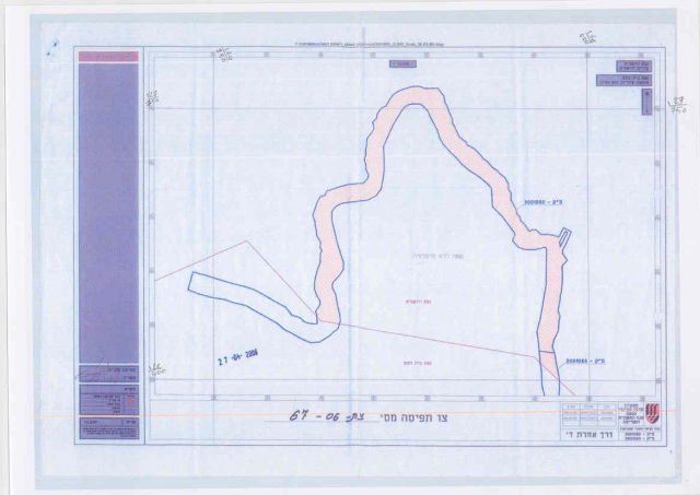
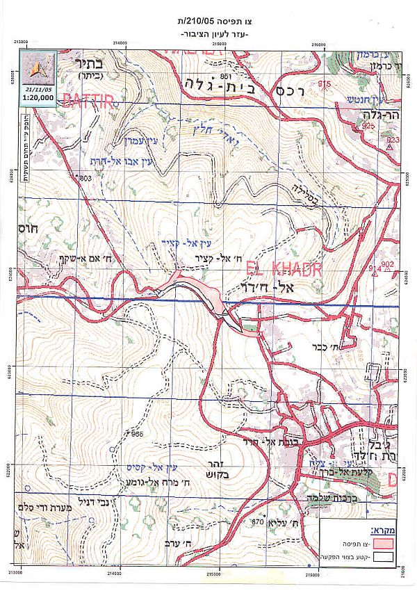
On November 21, 2005, the Israeli Army issued a new military order numbered (210/05/T Judea & Samaria 2005) to confiscate 85 dunums of agricultural lands that belong to three Palestinian Communities west of Bethlehem district, Beit Jala, Battir and Al Khader to construct a tunnel and terminal (crossing point) at the entrance of Al Khader village controlling movement between Bethlehem western rural villages (Battir, Husan, Nahhalin and Wadi Fukin) and Bethlehem Governorate. See Copy of military order

Conclusion
The International Court of Justice (ICJ) advisory opinion regarding the legality of the Segregation Wall issued on July 9, 2004 characterized the Segregation Wall as an illegal act committed by the Israeli occupation against the original owners of the land. Furthermore, the ICJ ruling emphasized all the resolutions issued by the United Nations General Assembly and its Security Council with regard to the legal status of the lands that Israel occupied following the 1967 war as occupied territory and that the Fourth Geneva Convention of August 12, 1949 is applicable to it in all of its terms.
According to the Fourth Geneva Convention, Article 53: 'Any destruction by the Occupying Power of real or personal property belonging individually or collectively to private persons, or to the State, or to other public authorities, or to social or cooperative organizations, is prohibited, except where such destruction is rendered absolutely necessary by military operations.'
Annex I
|
Israel Defense Forces Order to Seize lands n0 86/05/T According to my authorities as a Military Chief Commander in the Region of Judea and Samaria, and as I believe that it is imperative for military reasons due to the special security situation in the region, I order the following: 1- The 'Map' signed in scale 1: 50,000 and attached to the order is an essential part of this order. The 'Lands' : An area of land which is 766 dunums and 600 meters (10,466 meter long and 130 meter wide), marked in red in the map : Al Walajeh
Battir
Husan;
Al Qubo
Wad- Fukin
Surif
2- I announce by that the above mentioned lands are seized for military reasons. 3- The IDF seize the lands and have an absolute control over it that is given to the officer of the central command officer of lands who is responsible in the ministry of defense. 4- These copies are to be given by the District Co-ordination Office 'The DCO of Bethlehem to the owners of land. 5- Copies are found with maps for those who are interested in the following places :
6- The owners of land have the right to go to the DCO in Bethlehem in order to get more information about their right of land use expenses and compensation. 7- The Validity of this order starts at the date signed till 31/12/2008. 8- The name of this order is: Order to seize lands n0 86/05/T (Judea & Samaria) 2006. Yanner Nefah
|
Related Cases & Reports
Prepared by:
The Applied Research Institute – Jerusalem