Location
Some 9 Km northwest of Jerusalem lays the Palestinian village of Beit Iksa at an altitude of 670 meters above sea level. It is surrounded by Beit Surik village from the west, Ramot Allon settlement from the east, An Nabi Samuel village from the northeast, the Israeli settlement of Neve Sameul from the north and the 1949 Armistice Line from the south.
Area and Population: –
The entire geographical area of Beit Iksa occupies a total area of 7734 dunums. In the Oslo II Interim Agreement that was signed in September 1995 between the Palestinians and Israelis, the Palestinian areas in the West Bank were categorized into three areas A, B and C which aimed at a phased withdrawal of the Israeli military forces from these areas until the accomplishment of a final status agreement.
Area A: constitutes the areas where the Israeli army has pulled out fully and Palestinians have complete autonomy over administrative and security issues. Area A, according to the Oslo II agreement, covered the main cities of the West Bank, except for Hebron.
Area B: Palestinians have full control over the civil responsibilities and Israel continues to have overriding responsibility for security.
While Area (C): Palestinians have responsibility for civil life such as economics, health and education; however, Israel retains full control over security and administration related to territory.
Accordingly, the lands of Beit Iksa Village were classified to areas, B and C; but none of the village area was classified 'A'. A total of 591 dunums were classified as Area B (7.6 % of the total village area) where most of the built up area is concentrated; while the rest of the area, a total of 7143 dunums of Beit Iksa village lands were classified as Area C (92.4% of the total village area) and contain all the agricultural lands, the forests and the open spaces that belong to the village. See Table 1
|
Table 1: Classification of Lands according to Oslo II Agreement of 1995 |
||
|
Classification of Area |
Area in dunums |
% of the Village's total area |
|
Area A |
0 |
0 |
|
Area B |
591 |
7.6 |
|
Area C |
7143 |
92.4 |
|
Total Area |
7734 |
100 |
|
ARIJ GIS Database – 2005 |
||
The population of Beit Iksa village recorded 791 inhabitants in the year 1922; and according to the Palestinian state information service (SIS), the population continued to grow reaching up to 1410 in year 1945. However, following the 1967 war, the population of the village declined to 633 inhabitants; before it increase again to 949 and 1259 in the years 1987 and 1996, respectively. Today, the village's population is 1523 inhabitants (The Palestinian Central Bureau of Statistics-2005), where most of them hold Palestinian ID cards and occupy a built-up area of 417 dunums (0.417 Km2), 5.4 % of the village's total area.
The Israeli Colonization Activities in Beit Iksa Village
The village of Beit Iksa was subjected to the Israeli colonization activities following the 1967 war, when Israel captured the West Bank and the Gaza Strip. In 1973, Beit Iksa suffered the loss of 1347 dunums (1.347 km²) of its lands for the construction of the Israeli settlement Ramot Allon, which accommodates today approximately 40000 Israeli settlers.
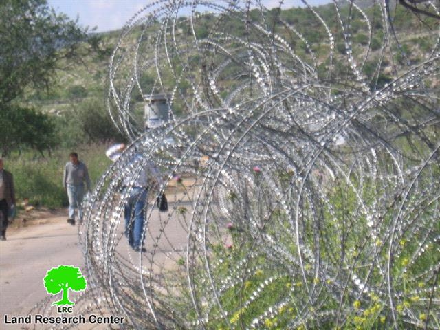
Following the eruption of the second Intifada in September 2000, the Israeli forces set up a checkpoint at the eastern entrance of the village, at the crossroad of Beit Iksa – Beit Hanina where the main northern entrance of Ramot settlement is located, which disrupted the lives of Palestinian villagers of Beit Iksa and affected their daily routine for many years.
Beit Iksa and the Israeli Segregation Wall
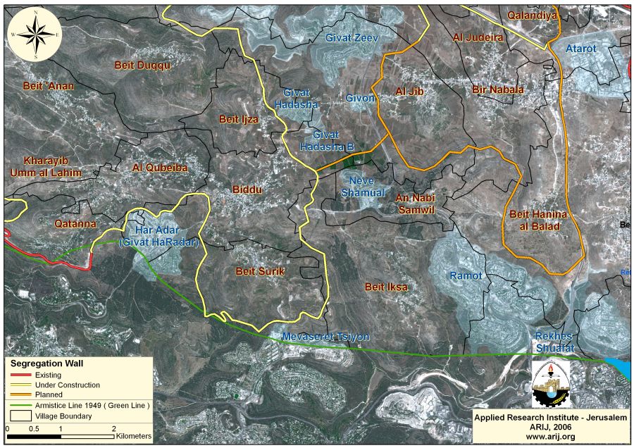
According to the earlier revised maps of the Segregation Wall particularly that of June 30, 2004 and February 20, 2005, the lands of Beit Iksa village were included in the area trapped between the Israeli Segregation Wall (inside Jerusalem city) and the 1949 Armistice Line (the Green Line). A total of 7244 dunums of lands, 93.7% of the village's total land area were about to become isolated inside the wall enclave or 'the Greater Jerusalem' plan which is going to extend 190 km around Jerusalem city and will include the 3 settlement blocs of Giv'at Ze'ev settlement bloc., Gosh Etzion settlement bloc, and the Ma'ale Adumim settlement bloc, separating it form the neighboring Palestinian communities located to the east, such as, Beit Surik, Biddu, Qatannah, Beit 'Anan and Beit Duqqu.
-
The Giv'at Ze'ev settlement bloc includes the settlements of Beit Horon, Beit Horon B, Giv'at Ze'ev, Giv'at Hadasha, Giv'at Hadasha B, Giv'on, Mevaseret Zion, Har Adar, Neve Sameul).
-
The Ma'ale Adumim settlement bloc includes the settlements of Ma'ale Adumim, Mitzpe Yehuda, Mishor Adumim industrial Zone, Kedar, Neve Brat, Neve Brat, Kfar Adumim, Almon (Anatot) and south Almon.
-
The Gosh Etzion settlement bloc includes the settlements of Efrat, Hadar Betar, Betar Illit, Neve Daniel, Rosh Tzurim, Allo Shevut, Kfar Etzion, Beit 'Ayn , Elezer, Gava'ot and Migdal 'Oz. See map of Greater Jerusalem (Wall around Jerusalem).
Chronology of Military Orders in Beit Iksa Village
On March 12, 2003, the Israeli High Council â?? Sub-committee for Road Construction issued notices (54/1) to construct a railway that will connect Jerusalem city with Tel Aviv. The railway, as planned, will pass through the Palestinian villages of Beit Iksa, Beit Surik and Biddu located northwest of Jerusalem city causing the confiscation of 340 dunums from the aforementioned villages.
On June 9, 2003, the Israeli Army issued a military order number 59 (1) declaring a vast area of land from Beit Iksa village lands as 'state land'. See Map of military order

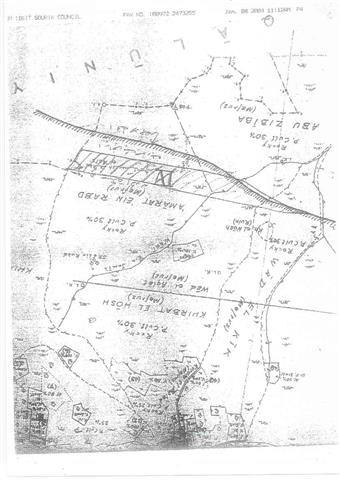
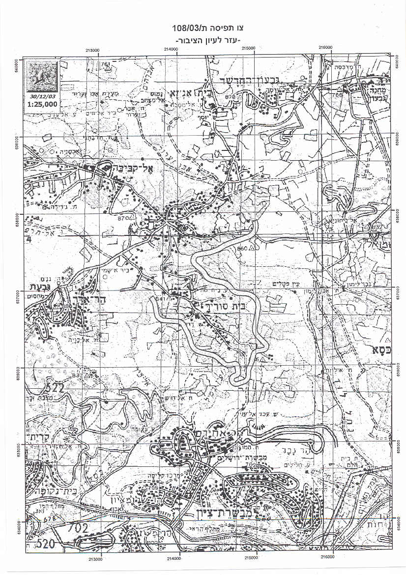
On September 12, 2003, the Israeli Occupation Forces distributed a new military order number (108/03/T) to villagers of Beit Surik, Biddu and Beit Iksa declaring the confiscation of 334.3 dunums of lands for military purposes. See copy of military order
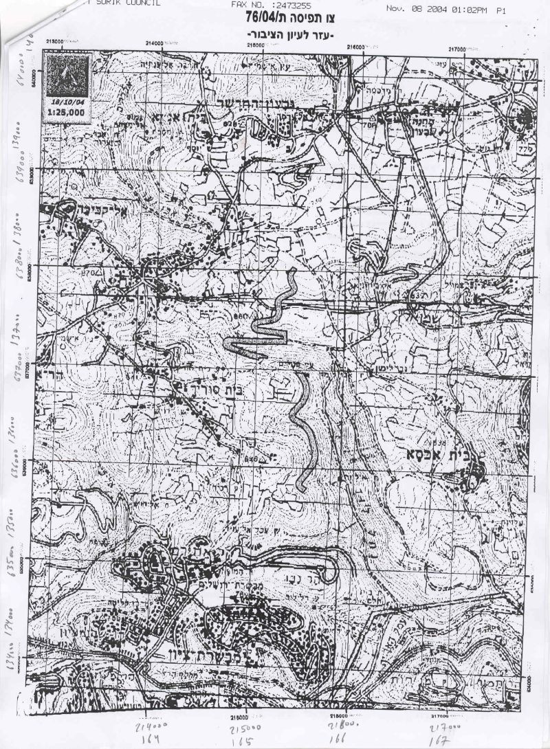
In year 2004, The Israeli Occupation forces handed out residents of Beit Iksa village and the neighboring Palestinian villages of Biddu, Neve Samuel and Beit Surik military order number (76/04/T) stating the confiscation of 263.7 dunums of lands for military purposes, mainly for constructing two sections of the Segregation Wall as shown in the attached maps. See copy of military order. See Annex 1 for English translation of the military order
An updated Israeli wall plan
On April 26, 2006, the newly elected Prime Minister, Ehud Olmert, ordered to speed up the closure of wall gaps in the Segregation Wall around Jerusalem city and overcome the legal cases that are petitioned at the Israeli high court by Palestinian Village councils who are objecting to the route of the wall around Jerusalem City' Mr. Olmert ordered that 'all gaps be closed immediately by means of temporary fences until they are permanently closed by the security fence,' according to the prime minister's office.(Haaretz Daily, 26 April, 2006).
In the case of Beit Iksa, it was decided that the village would be removed from Jerusalem enclave and that the fence would be constructed between the village and the settlement of Ramot Allon. See Map 1
On April 30, 2006, the Israeli ministry of defense published on its web site an updated wall plan which included changes in wall route in Ariel Settlement Bloc in Salfit, Al Jab'a village, south of Bethlehem, Al Walajeh Village northwest of Bethlehem, and Beit Iksa village, northwest Jerusalem city; as for the Jerusalem Envelope no changes were made except that it was decided to close off all the opening in the Wall route which awaits a court decision.
According to the updated wall plan, the wall in Beit Iksa was routed back to put the village of Beit Iksa outside the wall enclave to the northwest; mostly for security reasons. Despite the change, the village still loses much of its lands for the construction of the Segregation Wall where about 60% of its lands will be isolated behind the wall (inside Jerusalem). Table 1 below details the classification of lands of Beit Iksa village and the part of lands threatened with isolation.
Table 2: Land Use Land Cover (LULC) of Beit Iksa village
|
Beit Iksa Land Use Land Cover 2002 |
LULC of Beit Iksa Village lands wall west of the wall |
LULC of Beit Iksa Village segregated lands east of the wall |
Percent of lands isolated from total Village Boundary |
|
Arable land |
1316 |
613 |
7.93 |
|
Forests |
752 |
560 |
7.24 |
|
Heterogeneous agricultural areas |
680 |
135 |
1.75 |
|
Open spaces with little or no vegetation |
1118 |
574 |
7.42 |
|
Permanent crops |
448 |
230 |
2.97 |
|
Shrub and/or herbaceous vegetation associations |
1768 |
1193 |
15.43 |
|
Jewish Settlement |
1235 |
1235 |
15.97 |
|
Palestinian Built-up Area |
417 |
16 |
0.21 |
|
Total |
7734 |
4556 |
58.91 |
ARIJ GIS Database â?? 2005
It can be noticed from table 2 above that the area of the Jewish settlement (Ramot Allon) expanded from 1235 dunums in 2002 to 1347 dunums in 2004, an increase of 112 dunums. This expansion is clear evidence to the continuous Israeli settlement activities in the area.
In addition, the lands slated for isolation from Beit Iksa village are mostly agricultural lands as appears in Table 2 above which threaten the major source of income of the village residents. See Map 2

Annex 1:-
|
Israel Defense Forces |
|
According to my authorities as a Military Chief Commander in the Region of Judea and Samaria, and as I believe that it is imperative for military reasons due to the special security situation in the region, I order the following: 1. The ''Map'' signed in scale 1: 10000 and attached to the order is an essential part of this order. The ''Lands'' : An area of land which is 263.7 dunums ( out of which 41.7 are state land) marked in red in the map : Beit Surik: · Block 4: Kherbit Al Jabal. · Block 3: Wadi Al Jouz, Shu'ab Al Dahur Beit Iksa: · Block 6: Hareqat Al 'Aqab, 'Ein Al 'Aleiq, Zaquq Al Huseni. · Block 7:Thaher Badu, Nabus Hatab. · Block 8: Hareqat Al 'Arab, Qat'at Atbeesh. Biddu: · Block 3: Arjaman. Neve Sameul · Block 2: Thar 'Imran. |
|
2. I announce by that the above mentioned lands are seized for military reasons 3. The IDF seize the lands and have an absolute control over it that is given to the officer of the central command officer of lands who is responsible in the ministry of defense. 4. These copies are to be given by the District Co-ordination Office ''The DCO'' of Ramallah to the owners of land. 5. A) The announcement of this order to be distributed to land owners through the DCO in Ramallah district, hanging them on trees at Palestinian lands and farms or by any mean possibel 6. Copies are found with maps for those who are interested in the following places: · DCO of Ramallah. · Offices of the Juridical advisor in the region · The office of commander responsible in the ministry of defense in the civil administration. · Office responsible of absentee and public lands in the civil administration. 7. Owners of land have the right to object the order in 7 days after the visit mentioned in item (5.A) through the DCO in Ramallah or through the judicial advisor of the area. 8. The Validity of this order starts at the date signed till 31/12/2007. 9. The name of this order is: ''Order to seize lands n0 04/76/T (Judea & Samaria) 2004. Mosheh Kaplenski |
References:
1. Gov't agrees to reroute security fence. Retrieved 05 08, 2006, from Haaretz Jerusalem
Post Daily Newspaper,Website:http://www.jpost.com/servlet/Satellite?cid=1145961253542
&pagename=JPost%2FJPArticle%2FShowFull
2. (2006, 04 26). Acting PM orders to speed up Jerusalem fence construction. Retrieved
08 05, 2006, from Haaretz Daily News paper Web site: http://www.haaretz.com/hasen/
pages/ShArt.jhtml?itemNo=708039&contrassID=1&subContrassID=0&sbSubContrassID=0
3. (2006, 05 04). عزÙ? تجÙ?عات Ù?Ù?سطÙ?Ù?Ù?Ø© Ù? Ø¥Ù?رار خطة ضÙ? اÙ?Ù?دس . Retrieved 08 05, 2006, from
Applied Research Institute – Jerusalem Web site: https://poica.org/editor/case_studies/
view.php?recordID=824 (2006, 04 30). Israel's Security Fence. Retrieved 06 05, 2006,
from Israeli Ministry of Defence Web site: http://www.securityfence.mod.gov.il/Pages/ENG/route.htm
4. (2006, 02 01). Access to Jerusalem â?? New Military Order Limits West Bank Palestinian
Access. Retrieved 05 08, 2006, from United Nations Information Web site: http://domino.un.org/UNISPAL.NSF/22f431edb91c6f548525678a0051be1d/
293e655bc669da8c8525713800780c2c/$FILE/ochaHU0206_En.pdf
Prepared by
The Applied Research Institute – Jerusalem
ARIJ