Beit Sira is a Palestinian village located 15 Km to the southwest of Ramallah Governorate. It lies near the three demolished villages of Yalo, 'Imwas and Beit Nuba.
After the 1948 war the state of Israel was established and took control over 78% of Mandate Palestine. The 1949 Armistice Line (also known as the Green Line) was demarcated between the Israeli captured land and the rest of the Palestinian territory which came to be known as the 'West Bank' and administered by Jordan. As part of this demarcation a 'no man's land' was created along the Latrun area northwest of Jerusalem. The UNTSO (United Nations Truce Supervision Organization) were situated in the 'no man's land' to limit the friction along the armistice line between the parties. Parts of Beit Sira's lands were included within this area.
Before the 1948 war the village had a total area of 4713 dunums, of which 54 dunoms came to lie west of the Green Line and were taken over by the Israeli authorities. Today, Beit Sira has an area of 4659 dunums and the village built-up area comprises about 478 dunums. The village houses a total population of 2,841 inhabitants (PCBS, 2005). See Map 1

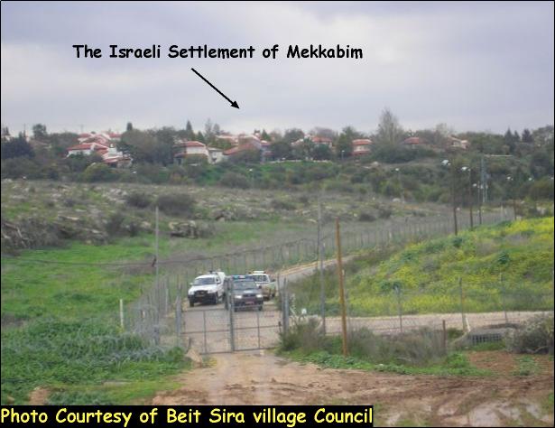
Beit Sira village is bounded from its northwestern part by the Israeli settlement bloc of Modin Illit particularly the settlement of Makkabim, from the southwestern part North Canada Park and Nevo Horon, from the eastern side Kharbathet Al Misbah, from the southeastern side Beit Liqya and from the southern side Beit Nuba. Additionally the village is bounded from the north by the Israeli bypass road # 443 which is connected with bypass road # 436 and extends 17 Km between Jerusalem and Tel Aviv. Road 443 supplies the settlements of Shilta, Kfar Rut, Makkabim, Beit Horon and Beit Horon B. It is worth mentioning that Palestinians are forbidden to access this road and have only one road that connects Beit Sira with the other Palestinian areas which is through the nearby village of Kharbathet Al Misbah located to the east of the village. Table one below shows the Israeli settlements surrounding Beit Sira village.
Table 1: Shows the Israeli settlements surrounding Beit Sira village
|
Settlement |
Date of Establishment |
Area |
Population |
|
Kfar Rut |
1977 |
835 |
200 |
|
1982 |
1941 |
NA |
|
|
Beit Horon B |
1977 |
274 |
741 |
|
North Canada Park |
NA |
131 |
NA |
|
Mevo Horon |
1969 |
1341 |
629 |
Source: ARIJ- GIS data base
During the past 39 years of occupation additional lands were confiscated to construct the Israeli settlement of Makkabim as 524 dunums from Beit Sira village became part of the settlement. Additionally the settlers in Mevo Horon seized another 727 dunums from Beit Sira and are cultivating it. On total 27% of the village lands were confiscated for these colonization activities
The village of Beit Sira faces the lack of medical, commercial and economical facilities. There are just two primary schools with 800 students in the village, one for boys and one for girls and most of the students who finish their education in the village and want to continue their studies are forced to go to 'Safa united school' which is located 7Km away from the village. It is worth mentioning that since the beginning of the second Intifada five years ago; more than 90% of the villagers who used to work in Israel became unemployed due to the Israeli closures of the area.
The Israeli violations continue in Beit Sira village
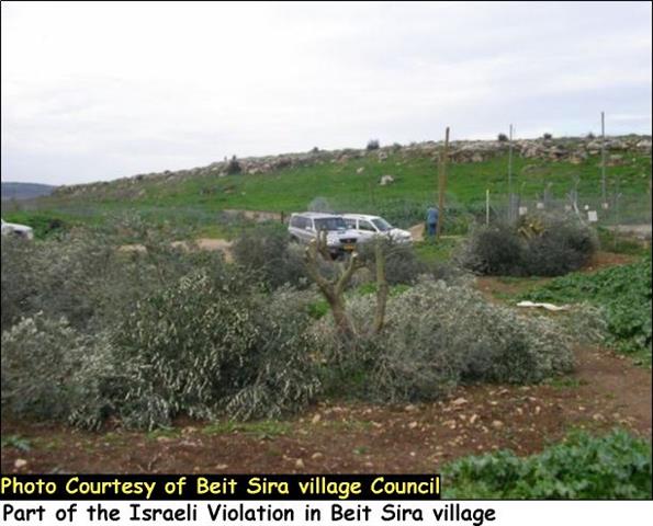
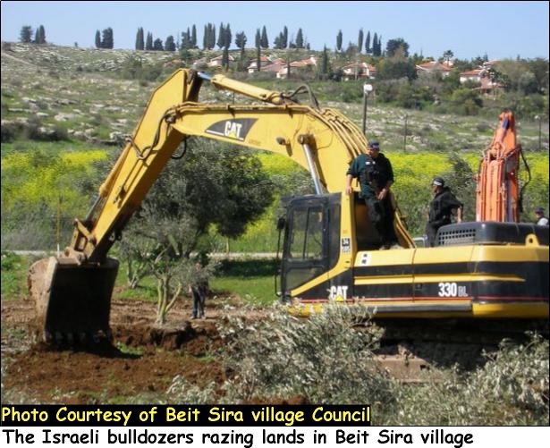
On February 25, 2006, the Israeli Forces accompanied by the Israeli bulldozers staged into Beit Sira village and illegally uprooted more than 1500 Olive trees and another 300 fruitful trees in order to clear the area for the construction of the Segregation Wall in the village. See Photo 1, Photo 2 & Photo 3
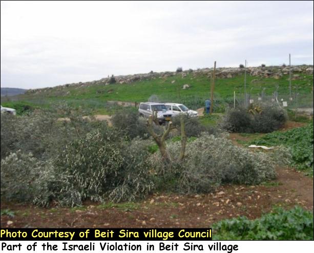
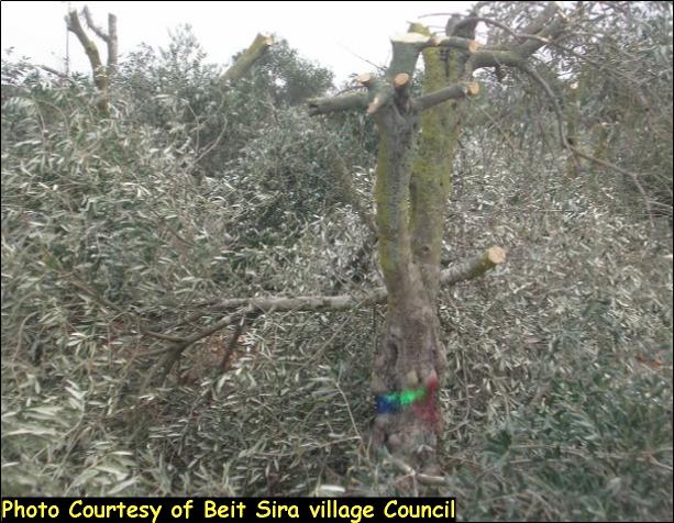
The affected Lands belong to more than 150 Palestinian families and are considered as their main source of income. It is worth to point out that the Palestinian residents are losing their homes, lives and their sources of income due to the harsh Israeli military actions. These Israeli aggressive measures prove that the main reason for the construction of the Wall is not security as the Israeli Government claims but it is to confiscate as much dunums of Palestinian lands. See pictures
Beit Sira and the Segregation Wall
Since the Israeli occupation of the West Bank and the Gaza Strip in 1967, Israel intensified its violations of confiscating Palestinian lands and uprooting fruitful trees in order to construct illegal Israeli settlements or expand existing ones. Today, Israel is solidifying this confiscation by constructing the Segregation Wall in the Palestinian Territory.
On March 3, 2003, the Israeli authorities issued military order # (T/22/03) to confiscate about 42 dunums of lands in Beit Sira village at favor of erecting the 2.3 Km length and 20 meters wide road which connects Makkabim settlement north with Mevo Horon in the south.
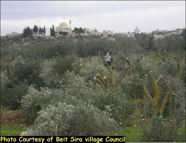
Furthermore, on September 14, 2003, another military order holding # (T/105/03, page 1 & page 2) was issued by the Israeli forces to confiscate 204.7 dunums of agricultural lands from Beit Sira and the nearby villages of Beit Liqya and Beit Nuba at favor of constructing a 100 meters wide and 2180 meters length of the Segregation Wall. But, on February 20, 2005, the Israeli Ministry of Defense published an updated plan of the Segregation Wall in the West Bank, whereby some changes in the Wall route were made in Beit Sira village. According to the new route of the Wall Beit Sira village will have 2.48 Km length of Segregation Wall. The total length of the existing parts of the Segregation Wall in the village reached to 0.46 Km whereby the under construction parts are to reach 2.02 Km. When the Segregation Wall is completed about 2974 dunums of lands are going to be isolated behind the Wall's path and landowners will have no more access to their own agricultural lands.See Photo 4, Photo 5 & Photo 6


Nearly 64% of Beit Sira lands will be isolated behind the Segregation Wall
According to the updated Segregation Wall path published on February 20th 2005, 64% (2974 dunums) of Beit Sira's lands will be isolated behind the Segregation Wall path leaving only 1685 dunums for the village.
74% of the Arable land that lies on the lands of Beit Sira will be entirely isolated behind the Wall and the local villagers will no longer be able to access it. Also, 58% of the open space and 66% of the shrub or herbaceous vegetation associations in the village will be isolated, which will impose pediments to future development of the village. Table 2 below shows the land classification inside the village boundary and the land that will be isolated behind the Wall.
Table 2: Land Use Land Cover in Beit Sira Village
|
Land Use Land Cover
|
LULC inside the village boundary Beit Sira |
LULC in the area isolated west of the Wall |
Percentage |
|
Arable land |
2155 |
1593 |
74% |
|
Heterogeneous agricultural areas |
56 |
6 |
11% |
|
Open spaces with little or no vegetation |
1155 |
669 |
58% |
|
Permanent crops |
21 |
0 |
0% |
|
Shrub and/or herbaceous vegetation associations |
270 |
177 |
66% |
|
Palestinian Built-up area |
478 |
5 |
1% |
|
Jewish settlement |
524 |
524 |
100% |
|
|
|
|
|
|
Total |
4659 |
2974 |
64% |
Source: ARIJ database- GIS, 2005
Conclusion
The Segregation Wall that the Israeli government is constructing in the heart of the West Bank aims at grabbing the most fertile lands. The case for Beit Sira is just one example of this land grab where 64% of the village will be totally segregated from the village. The Segregation Wall is a direct violation to the international Humanitarian Law and the international conventions of which are The Hague Regulations and the Fourth Geneva Convention.
The Hague Regulations forbids an occupying power 'to destroy or seize the enemy's property, unless such destruction or seizure be imperatively demanded by the necessities of war' (Article 23).
The confiscation and destruction of Palestinian land is a violation of the Fourth Geneva Convention, Article 147 of which clearly prohibits, ''extensive destruction and appropriation of property, not justified by military necessity and carried out unlawfully and wantonly.'' Violations of Articles of the Fourth Geneva Convention constitute grave breaches of the Convention and should be prosecuted as War Crimes.
Prepared by:
The Applied Research Institute – Jerusalem


