Al-Walajeh Village is located 8.5 km to the southwest of Jerusalem city, and about 4 kilometers to the northwest of Bethlehem city. The Village rises 750 meters above the sea level, and the population reached 1644 people in 2005 (Projected Mid-Year Population for Bethlehem Governorate by Locality 2004- 2006).
Al-Walajeh Village is bordered by Battir and Husan villages from the southwest, by Sharafat village and Gilo settlement (established in 1971) from the east and by Har Gilo settlement (established in 1972) from the southeast. Before the 1948 war, the village spread over an area of 17.793 km2 and its boundaries extended westwards beyond the Armistice Line (Green Line). After the 1948 the village lost 75% of its lands and came to spread over a total land of 4.403 km2.
In 1967 after the Israeli occupation of the rest of the Palestinian Territory, the Israeli government unilaterally expanded Jerusalem Municipal boundary from 6.5 km² to 71 km² to include lands from nearby villages, these lands where then annexed to the state of Israel. Part of Al Walajeh village, in particular Ein Juwaiza neighborhood which has an area of 2.095 km2 was included within this annexed land.
In 1985 the Israeli municipality started issuing demolition orders to houses constructed in Ain Juwaiza neighborhood under the pretext of having no building license and violating the Israeli building codes. These orders are still being sent to the residents.
The Israeli Closures
The Israeli closure and isolation policy started in Al Walajeh in the nineties, but intensified after the out brake of the second Intifada in 2000, where the village was completely isolated from its surrounding villages and cities. The road that leads to Beit Jala through Cremisan monastery was closed, and the Israeli forces placed a checkpoint on the southeastern entrance of the village nearby Har Gilo settlement. These mobility restrictions resulted in difficulties and sufferings to the residents of the village, in addition to the continuous Israeli provocations at the checkpoints, such as holding up the cars and buses without any justification. In 2004 the checkpoint between Al Walajeh and Beit Jala was removed, but it is often replaced by a flying checkpoint.
The enclavement of Al Walajeh through the Segregation Wall and a Crossing point
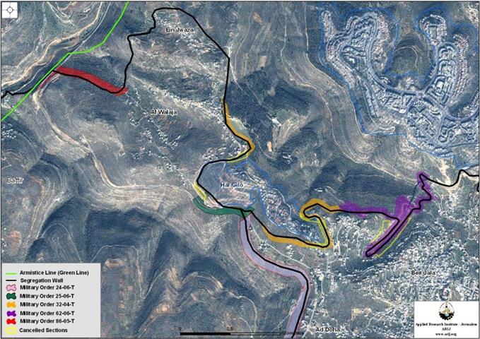
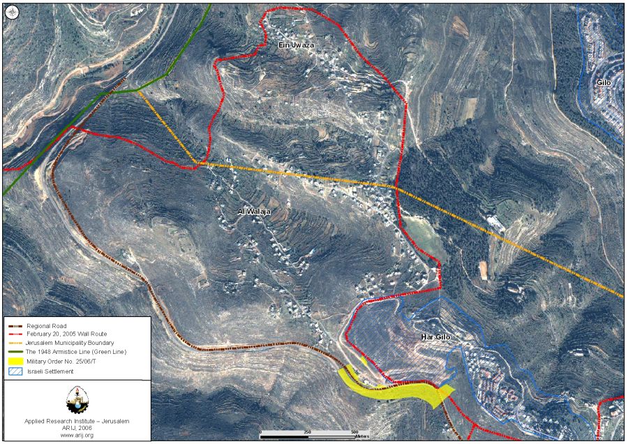
From July 2003 till February 2006, six military orders were issued for Al Walajeh. On total, the Segregation Wall stretches for a length of 4.1 kilometers along the village and isolates 1,600 dunums from Al Walajeh lands placing them north and west of the Segregation Wall. The issued military orders are:
T/44/03, which states the confiscation of 23.8 dunums of lands from Al Walajeh and Beit Jala for the construction of the Segregation Wall. This order was updated by military order number T/32/04 and by the updated Wall plan published on February 20th 2005 on the Israeli Ministry of Defenseâ??s website.
T/32/04 issued on March 25th, 2004 and stipulates the confiscation of 175.6 dunums from Al Walajeh and Beit Jala lands. This order was updated in November 2005.
T/75/05, which confiscates 9.2 dunums from Al Walajeh and Beit Jala lands, this military order was updated by military order number
T/85/05 issued on April 1st, 2005 and states the confiscation of 14.3 dunums from Al Walajeh and Beit Jala lands. This military order was modified by military order number T/32/04 which was updated in November 2005.
T/86/05, which states the confiscation of 756.5 dunums from the villages of Al Walajeh, Battir, Husan, Al Qabu, Wad Fuqin and Surif. This order was updated on February 19, 2006. (See Map 1)

On February 09, 2006, the Israeli Occupation Forces issued a new military order number (T/25/06) to confiscate 39.8 dunums of lands from Al Walajeh village and Beit Jala city, block 3 and block 2 respectively for military purposes, mainly for the construction of a new Terminal in the area named 'Har Gilo Terminal' which will control the access of Al Walajeh residents into and out of the village.
The terminal plan is complementary to the Israeli Segregation Wall plan which is planned on the lands of the village; as the Wall is intended to encircle the village from its northern, eastern and western sides. While the southern part of the village is bounded by the Israeli bypass road number 436 which connects Har Gilo settlement with west Jerusalem. The Palestinian residents are prohibited from using this road.
Thus Al Walajeh village will be totally enclaved and the only entrance/exit to the village will be through the Israeli controlled Har Gilo terminal. Al Walajeh residents will be isolated from the nearby villages and cities, cut off from the main urban services (clinics, hospitals, schoolsâ?¦) and from their agricultural lands located north and west of the Segregation Wall. (See Map 2)
House demolitions continue
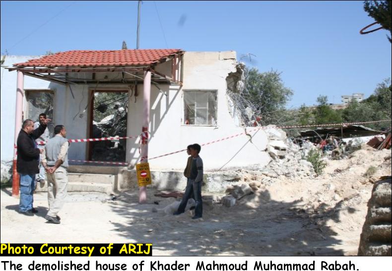
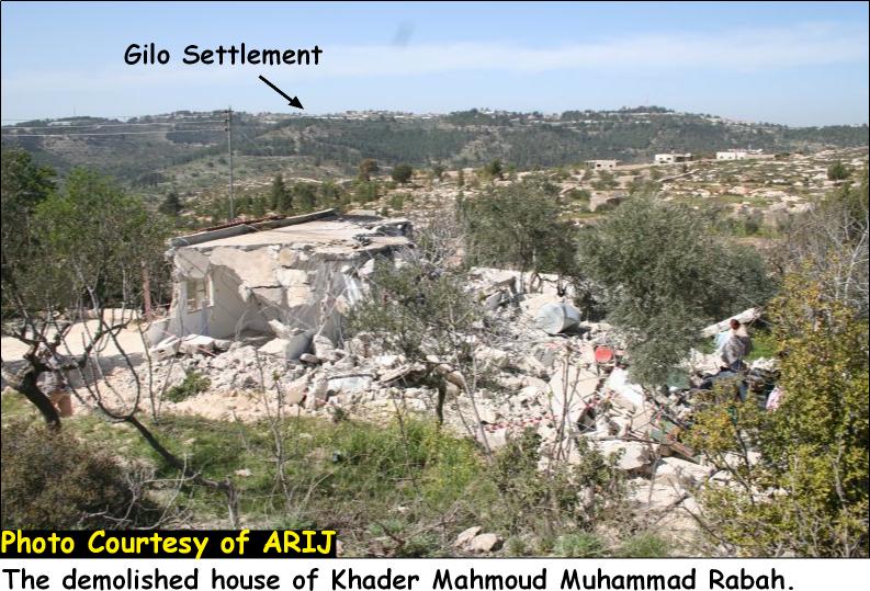
On March 22, 2006, the Israeli bulldozers supported by the Israeli Occupation Forces (IOF) broke into Al Walajeh Village and demolish two Palestinian houses owned by local residents of the village. During the demolition, the Israeli forces announced the area as closed military area for two hours, until the demolition was over. (See Map 3)

The first demolished house is owned by Khader Mahmoud Mohammad Rabah, and was demolished under the pretext of being unlicensed. This one-storey house had an area of 120 square meters and was built in 1995 and cost the owner about 90,000 NIS (USD 20000).
After the Israeli bulldozers started the demolition, the Israeli Court issued an order to stop the demolition for two hours in order to give the owner of the house a chance to pay 80,000 NIS as a fine, but when the order arrived, the house was half demolished and the bulldozers continued the demolition. (See Pictures 1and 2)
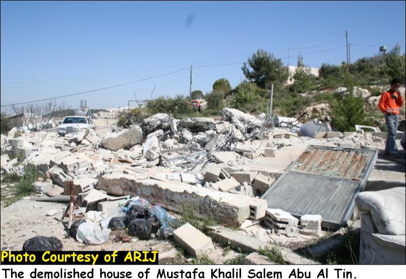
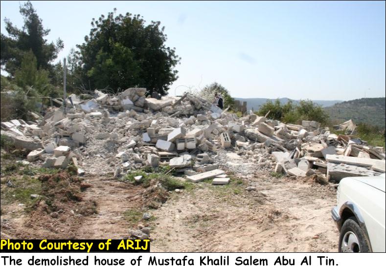
The second house is owned by Mustafa Khalil Salim Abu Al Tin. This one-storey house is a home for 6 family members. The house was built in 1998, had an area of 85 square meters and cost 30,000 NIS (About USD 6700). This was the second time the house got demolished as in the year 1998, the first house constructed by the owner was also demolished but the owner rebuilt it. (See Pictures 3 and 4)
Since the outbreak of the second Intifada in September 2000 till March 2006, 21 houses were demolished in Al Walajeh village by the Israeli IOF (ARIJ database, 2005).
Israeli plans in Al Walajeh
In the same time that the Israeli bulldozers are demolishing the Palestinian houses, the Israeli government is setting plans to expand the nearby settlements on expropriated Palestinian lands from Al Walajeh and the nearby villages and cities.
In June 2004, the Israeli authorities announced the construction of a new Israeli settlement in Al Walajeh Village. The plan envisions the building of 'Giv'at Yael' settlement on 2,000 dunums of Palestinian lands. Whereby, more than 13,200 housing units will be constructed which will be able to absorb 55,000 illegal Israeli settlers. This settlement will physically complete the ring of settlements that separate Jerusalem and encircle Bethlehem starting at Har Homa extending to Gilo and Har Gilo, linking with the planned Giv'at Yael and continuing to 'Gush Etzion' bloc in the southwestern part of Bethlehem Governorate.
Conclusion
These combined Israeli practices aim to tighten the grip on Al Walajeh Village, isolate it by the Segregation Wall, confiscate its lands, demolish its houses and displace its local residents.
Under the Forth Geneva Convention, Israel is prohibited from destroying Palestinian property or employing collective punishment, Article 53 reads: 'Any destruction by the Occupying Power of real or personal property belonging individually or collectively to private persons or to the State, or to the public authorities, or to social or corporative organizations, is prohibited, except where such destruction is rendered absolutely necessary by military operations.'
The enclavement of Al Walajeh Village by the Segregation Wall from three sides and by the Israeli bypass road from the fourth side will transform the local Palestinian residents into prisoners where the only access to/from the village will be through an Israeli controlled terminal. These practices clearly violate the Universal Declaration of human rights, the International covenants as well as the rules of International Humanitarian Law.
-
Article 2 in the Universal Declaration of Human Rights reads that: 'Everyone is entitled to all the rights and freedoms set forth in this Declaration, without distinction of any kind, such as race, color, sex, language, religion, political or other opinion, national or social origin, property, birth or other status. Furthermore, no distinction shall be made on the basis of the political, jurisdictional or international status of the country or territory to which a person belongs, whether it be independent, trust, non-self-governing or under any other limitation of sovereignty.'
-
Article 3 states that 'everyone has the right to life, liberty and security of person'.
-
Article 13 states also that '(1) Everyone has the right to freedom of movement and residence within the borders of each state.'
-
Article 25 states that '(1) Everyone has the right to a standard of living adequate for the health and well-being of himself and of his family, including food, clothing, housing and medical care and necessary social services, and the right to security in the event of unemployment, sickness, disability, widowhood, old age or other lack of livelihood in circumstances beyond his control.'
References:
Palestinian Central Bureau of Statistics, (n.d.). Projected mid -year population for Bethlehem governorate by locality 2004- 2006. From Demographic statistics Web site: http://www.pcbs.gov.ps/Portals/_pcbs/populati/pop10.aspx
Prepared by:
The Applied Research Institute – Jerusalem


