Location
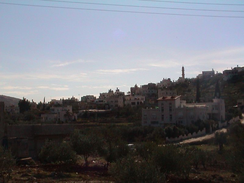
Al Lubban Al Gharbi is a small village, located approximately 21 kilometers northwest of Ramallah city and reaches up 387 meters above the sea level. Al Lubban's lands are mostly cultivated with Almonds and Olive trees. The village is surrounded by Rantis from the southwest, A'boud from the southeast, Deir Bullut from the northeast and the illegal Israeli settlements of Bet Arye and Ofarim from the east and southeast respectively. See Photo 1
Area and Population
The village has an area of 9694 dunoms and its population reached 1458 in 2005 (the Palestinian Central Bureau of Statistics 2005). While, the villageâ??s built-up area is 335 dunums (0.335 km²).
Al Luban Al Gharbi has a number of social infrastructure facilities which include an elementary school that hosts 500 students, a kindergarten that hosts 144 children and two clinics.
The Israeli Settlements in Al Lubban Al Gharbi Village
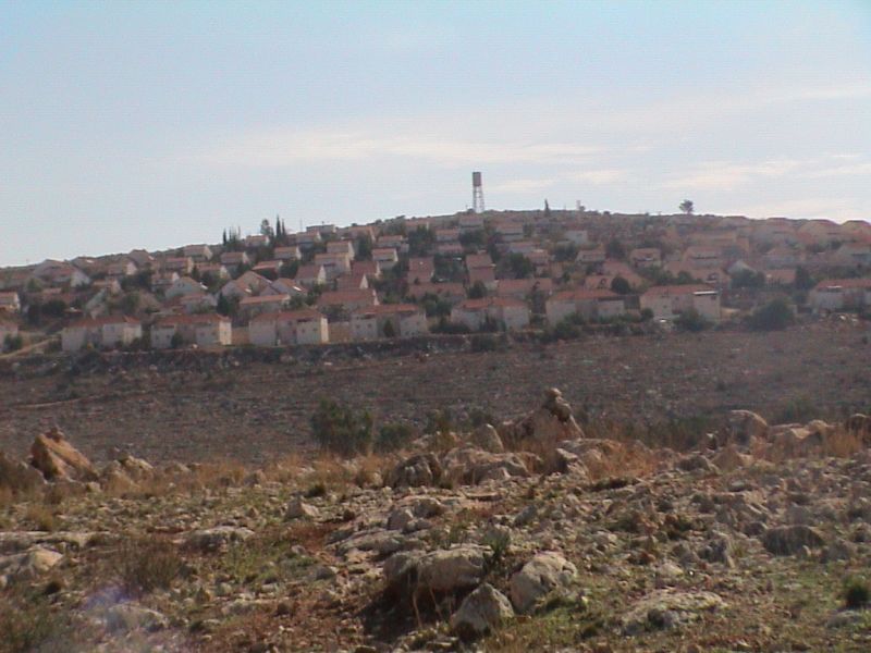
In 1980, the Israeli authorities had confiscated vast area of agricultural lands in the village for the establishment of the first Israeli settlement on Al Lubban Al Gharbi's lands, the settlement of Beit Arye. Afterwards in 1983, the Israeli authorities announced the establishment of another Israeli settlement called Ofarim . The two settlements are located to the east and southeast of Al Lubban Al Gharbi and occupy an area of 894 dunums (0.894 km�²) 9% of the village's total area. Table 1 below shows the total number of Israeli Settlements in Al Lubban Al Gharbi village. See Photo 2 & Photo 3

|
Table 1: the illegal Israeli settlements in Al Lubban Al Gharbi village. |
|||||
|
|
|||||
|
Settlement name |
Date of establishment |
Total area August 2004 (in dunoms) |
Occupies from Al Luban village boundary (in km�²) |
Distance from village (km) |
Location from Al Lubban Al Gharbi village |
|
|
|
|
|
|
|
|
Ofarim |
1983 |
545 |
342 |
1.5 |
Southeast |
|
Beit Arye |
1980 |
1420 |
552 |
0.5 |
East |
|
|
|
|
|
|
|
|
Total |
1965 |
894 |
|
||
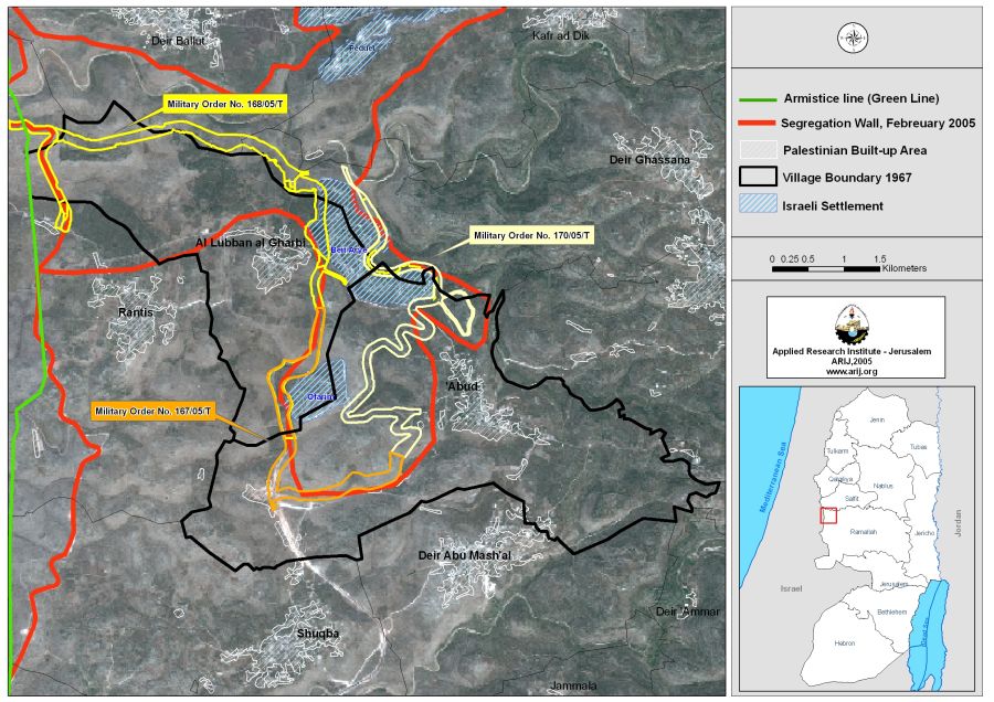
Al Lubban Al Gharbi and the Israeli Segregation Wall
Al Lubban Al Gharby, as many Palestinian villages which are in parallel or worse positions, is now facing the threat of the Israeli Segregation Plan. On February 20, 2005, the Israeli Ministry of Defense issued an updated plan for the path route of the Segregation Wall in the West Bank. According to the plan, the section of the Wall on the village lands has a total length of (7.286 km) extending from the northwest to the northeast and then heads towards the southeast of Al Lubban Al Gharbi. 5758 dunums of Al Lubban Al Gharby lands will be isolated (north and east) of the Segregation Wall, that is 59% of Al Lubanâ??s land will be inaccessible to the local Palestinians. 2166 dunums (66%) of the agricultural lands in the village will be isolated behind the Wall. These agricultural lands are mostly cultivated with Olive trees. Additionally 56% of the open spaces and 778 dunums (49%) of the area with shrubs or herbaceous vegetation in the village will be isolated. Table three below shows the Land Use Land Cover of Al Lubban village and the land Use Land Cover of the areas isolated by the Segregation Wall, (ARIJ GIS database 2002). See Table 2
Table 2: Land Use Land Cover of Al Lubban Al Gharbi
|
Type of land |
Al Lubban al Gharbi village boundary (dunums) |
Area of land north and east of the Segregation Wall (dunums) that will be isolated from the village |
Percentage of land that will be isolated |
Area of lands south and west of the Segregation Wall (dunums) |
|
|
|
|
|
|
|
Agricultural area |
3285 |
2166 |
66% |
1120 |
|
Shrub and/or herbaceous vegetation |
1574 |
778 |
49% |
795 |
| Open spaces with little or no vegetation | 3803 | 2131 | 56% | 1673 |
| Israeli settlementâ??s built-up area | 697 | 683 | 98% | 14 |
|
Palestinian Built-up Area |
335 |
0 |
0 |
335 |
|
|
|
|
|
|
|
Total |
9,694 |
5,758 |
59% |
3,937 |
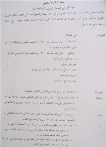
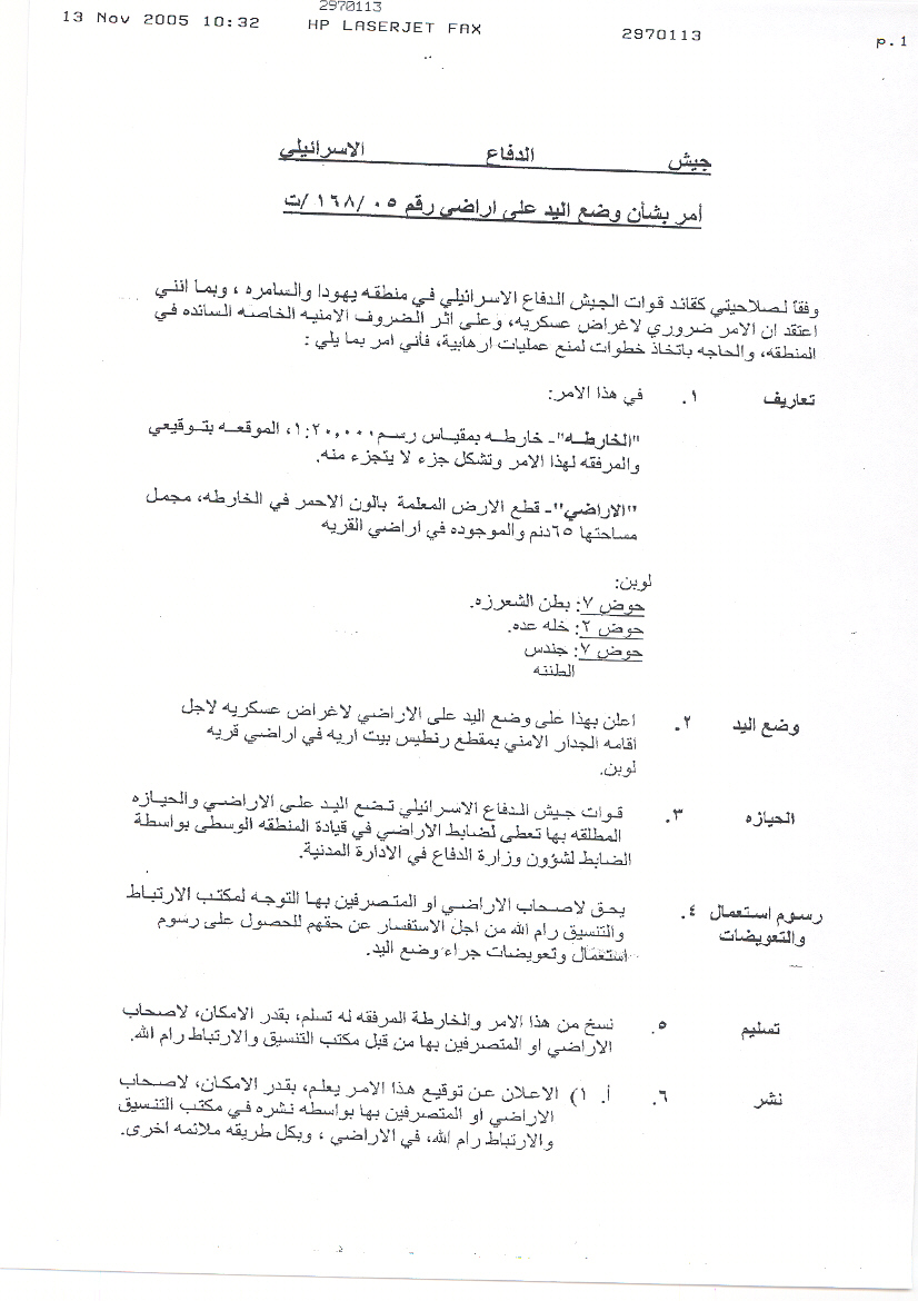
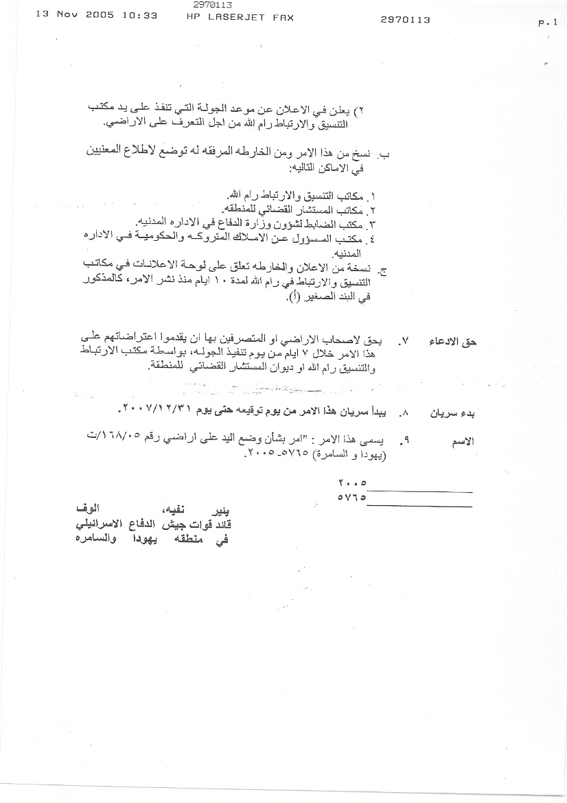
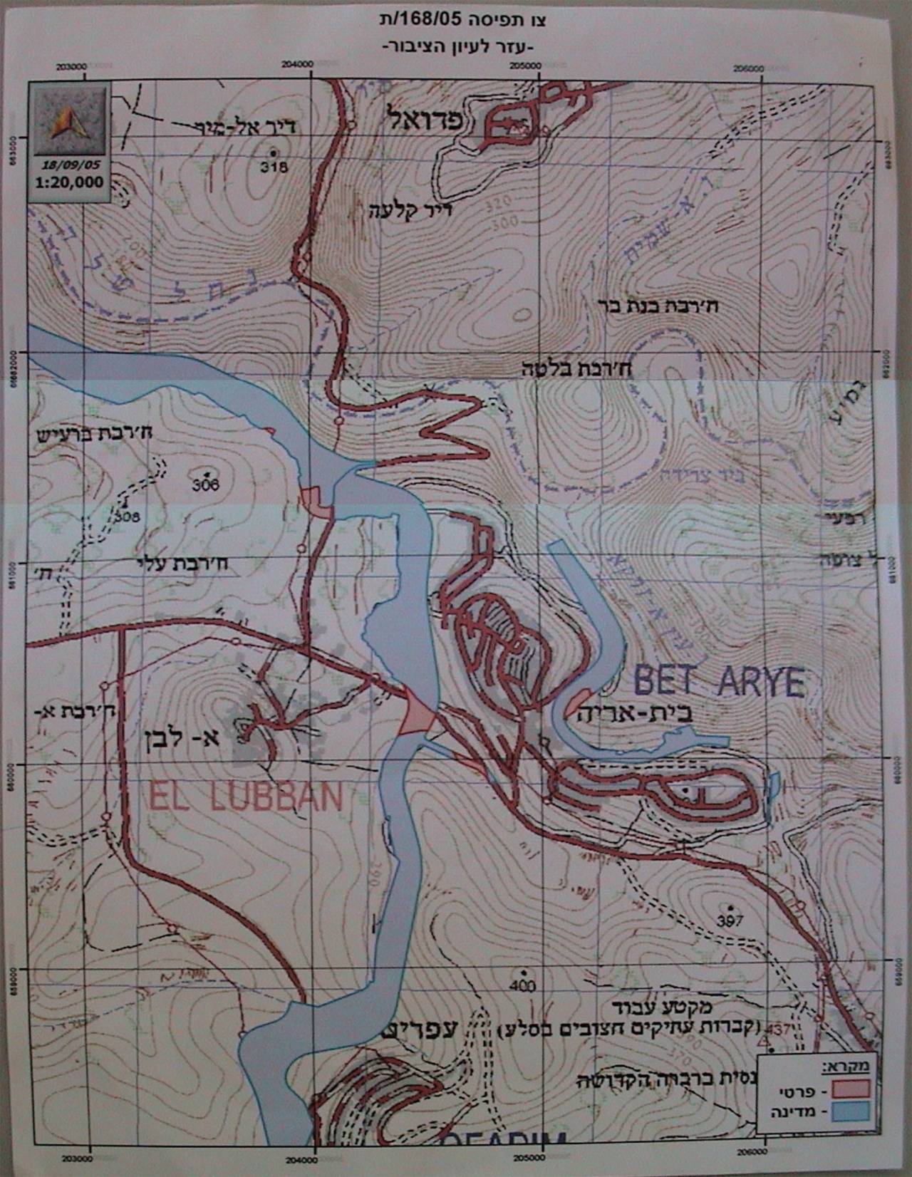
On September 18th, 2005, the Israeli occupation forces handed Al Lubban Al Gharbi villagers military order number (168/05/T Judia & Samaria, 2005) stating the confiscation of 65 dunums of their agricultural land for the construction of the Segregation Wall. After few weeks, the Israeli bulldozers started razing lands in the eastern part of Al Lubban village, setting the path of the Segregation Wall in the area. See Photo 4 & Photo 5 and translation of military order below & and translation of military order below
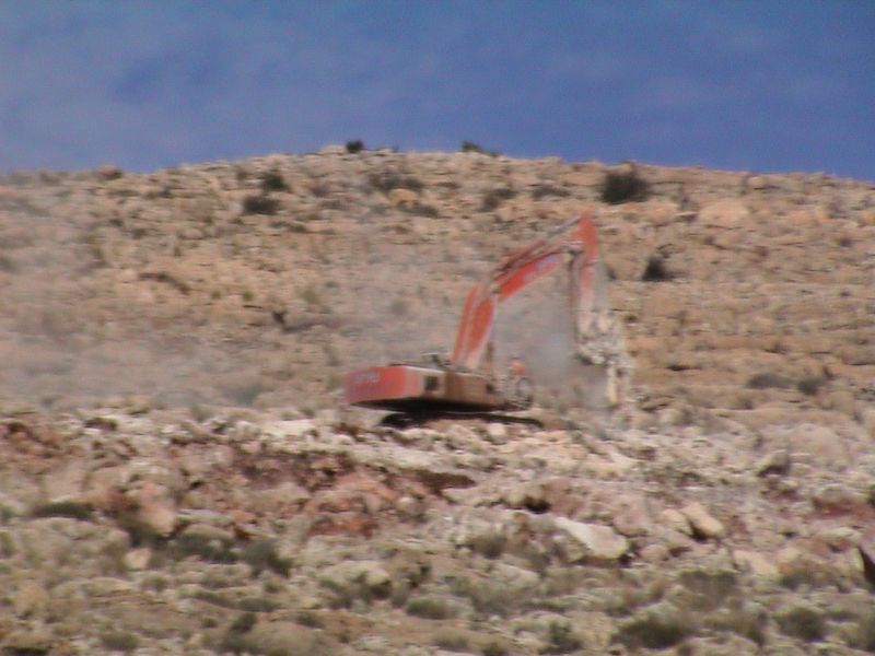

Table 3: Translation of Military order
|
Israel Defense Forces Order to Seize lands n0 168/05/T According to my authorities as a Military Chief Commander in the Region of Judea and Samaria, and as I believe that it is imperative for military reasons due to the special security situation in the region, I order the following: 1-The 'Map' signed in scale 1: 20,000 and attached to the order is an essential part of this order. The 'Lands' : An area of land which is 65 dunums, marked in red in the map : Al Lubban
2- I announce by that the above mentioned lands are seized for military reasons 3- The IDF seize the lands and have an absolute control over it that is given to the officer of the central command officer of lands who is responsible in the ministry of defense. 4- These copies are to be given by the District Co-ordination Office 'The DCO of Ramallah to the owners of land. 5- Copies are found with maps for those who are interested in the following places :
6- The owners of land have the right to go to the DCO in Ramallah in order to get more information about their right of land use expenses and compensation. 7- The Validity of this order starts at the date signed till 31/12/2007 8- The name of this order is: Order to seize lands n0 168/05/T (Judea & Samaria) 2005. Yanner Nefah |
Although, the military order handed to Al Lubban Al Gharby in September 2005 showed that the Segregation Wall was moved few meters to the north, it is still unclear which plan will the Israeli forces follow (military order number (168/05/T) or to the plan issued on February 20, 2005), see map 1
Conclusion
The aim of the Segregation Wall is to grab as much as possible of the most fertile and strategic Palestinian land and annex it to Israel. Al Lubban is on of the Palestinian villages that suffers from the Israeli violations where 59% of the village lands will be isolated behind the Wall. 38% of the isolated lands are agricultural lands that the villagers depend on for their living and which constitute a major economic income. Additionally 51% of the isolated lands are open space, shrubs or herbaceous vegetation associations, which constitute the future extensions for the village. The sustainability of the village and of the whole Palestinian territory comes under question due to such Israeli actions which are forbidden under international law. The Hague Regulations expressly forbids an occupying power 'to destroy or seize the enemy's property, unless such destruction or seizure be imperatively demanded by the necessities of war' (Article 23).
:::::::::::::::____
[1] This is the area of the settlements inside the village boundary of Al Luban in 2002 while in 2004 it reached to 894 dunums
Prepared by:
The Applied Research Institute – Jerusalem