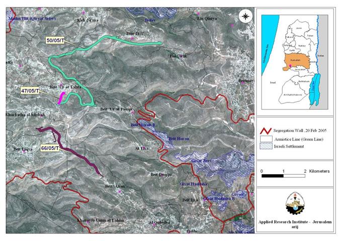
In April 2005, the Israeli Occupation Forces handed out residents of western Ramallah villages, Beit 'Ur Al Tahta, Beit 'Ur Al Fauqa, Deir Ibzi, Beit 'Anan, Kharatha al Misbah and Beit Leqia three military orders to erect a 100 meters width and 17.08 km long colonial road on the lands of the aforementioned villages under the pretext of facilitating the movement of Palestinians living in these villages and state the confiscation of 1556.1 dunums (1.5561 km�?�²) of Palestinian agricultural lands.
The orders carry the numbers (50/05/T Judea & Samaria, 2005), (66/05/T Judea & Samaria, 2005) and (47/05/T Judea & Samaria, 2005) and are signed by the Israeli chief commander Ya'er Nafeh. Table one below details the area each military order confiscates. A Translation of the military orders is found in Appendix II;
Table 1: Military Orders served to western Ramallah Villages
|
Number of order |
Area in (Dunums) |
|
|
|
|
50/05/T Judea & Samaria, 2005 ( 1, 2, 3 & 4), & ), & ), , & ) |
1123 |
|
66/05/T Judea & Samaria, 2005 |
430.9 |
|
47/05/T Judea & Samaria, 2005 |
2.2 |
|
|
|
|
Total |
1556.1 |
An analysis conducted by the geographical Information System unit at the Applied Research Institute �¢?? Jerusalem showed that Military order number (66/05/T) states the construction of the first part of the colonial road where it will cut a total of 204 dunums of the northern part of Beit 'Anan village lands and moves towards the eastern part of Beit Leqia village to again segregate another 121 dunums of the village's lands to finally reach Kharbatha Al Misbah Village from the south to confiscate another 109 dunums of the village boundary's area.
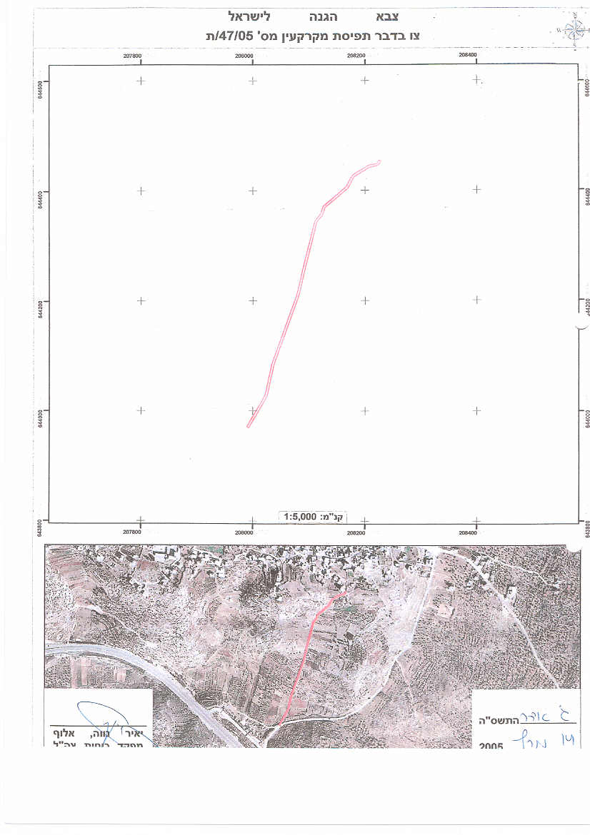
While military orders number (50/05/T) and (47/05/T) assert the construction of the second part of the colonial road which starts from the northwestern part of Beit 'Ur Al Fuqa village lands and confiscate about 11 dunums of agricultural lands. The road, as seen in map 1, continues towards the southern and eastern parts of Beit 'Ur at Tahta village lands where it confiscates 386 dunums of the village boundary's area to finally reach Deir Ibzi' village where it will confiscate another 742 dunums of the village boundary area. See Table 2 & Map 1 below
|
Military Order |
Village name |
Area of village boundary (dunums) |
Land confiscated from Village boundary (dunums) |
Total length (km) |
|
|
|
|
|
|
|
military order # (66/05/T) |
10,069 |
204 |
2.51 |
|
|
Beit lqyia |
14,254 |
121 |
1.73 |
|
|
Kharbat Al Mesbah |
4,431 |
109 |
1.56 |
|
|
military order # (50/05/T) and military order number (47/05/T) |
Deir Ibzi |
14,424 |
742 |
7.5 |
|
Beit 'Ur At Tahta |
4,681 |
386 |
4.2 |
|
|
Beit 'Ur Al Foqa |
3,840 |
11 |
0.18 |
|
|
Total
|
51,699
|
1,573
|
17.68
|
|
Source: ARIJ Geographical & Information System Unit �¢?? 2005

Map 1: Map of Military orders
Effects of constructing the road on western Ramallah Village lands
The location and the timing of the Israeli proposed roads raise suspensions especially that they create an indirect separation between several Palestinian villages (Beit Anan, Beit Leqia, Beit Sira, Khirbit Misbah, Beit Ur Al-Fouqa, Beit Ur Al-Tihta, Saffa, Deir Ebzed, Kafer Ni'ma, and Ein Arik) and their lands. These large agricultural and open space areas will be trapped between the newly proposed roads (to be built under Israeli military orders 50/05/T, 47/05/T and 66/05/T) and the Segregation Wall set to grab the Giva't Ze'ev settlement bloc (Beit Horon, Beit Horon B, Giv'at Ze'ev, Giv'at Hadasha, Giv'at Hadasha B and Giv'on) northwest of Jerusalem. In addition, the construction of this road will come on about 30,000 olive trees, as estimated by village councils, and will cause the loss of one major source of income for Palestinian families. These vast agricultural and open areas in question will comprise a perfect expansion grounds for Giva't Ze'ev settlement bloc, even with the Segregation Wall closing off access to these lands. It is also expected that the lands in question will be either off limits to Palestinian owners or under restriction particularly to expansion of the built up areas and development projects. The new roads are part of a subsequent plan to the Israeli Segregation Wall, to complete land and townships isolation process while fortifying the settlement existence with even more lands to expand.
Israel's Original Plan
The new military order to construct these new roads comes as a part of an Israeli equilateral triangle (the settlements, the bypass roads and the Segregation Wall) to abolish the Palestinian dream of an independent contiguity State. On the third quarter of October 2004, Israel announced plans to construct over 500 Km of roads distributed systematically in the West Bank in a way that will segregate the West Bank into dozen of cantons with no physical contiguity in addition to 18 tunnels and under ground passages that will be constructed to fortify the scheme and create transportation contiguity in the West Bank. This plan was reinforced in October 2005 when the Israeli government revealed its intention to create an apartheid road system in the West Bank, were the Israeli settlers would ride on the well connected bypass road system that was constructed on confiscated Palestinian land, and an alternative road system for the Palestinians would be created. In cases of overlap between the Israeli bypass road and the roads the Palestinians are allowed to use, tunnels are introduced, as is the case with bypass road number 443 and the tunnel underneath which connects Khirbit Misbah and Beit Ur Al-Tihta.
Israel has always pushed to incorporate international financing for its road scheme. At the 3rd quarter of 2004, Giora Eiland Israel�¢??s director of national security, requested international funding for the project, but at that time the international community, mainly the EU, United States and Japan refused to fund such Israeli plans. However, recent development at other areas (occupied East Jerusalem) may explain Israel's reawaken optimism to bring in international sponsorship to its road scheme; as the railway and tunnels going under construction in occupied East Jerusalem to link between Giva't Ze'ev settlement bloc and downtown Jerusalem is being carried out by an international French corporation; partially owned by the French government.
Appendix I
Villages' profile
Location & Population
The villages' of Beit Anan, Beit Lqyia, Deir Ibzi, Beit 'Ur At Tahat, Beit 'Ur Al Foqa and Kharbet Al Mesbah are located approximately 11 to 18 kilometers to the west of Ramallah city. Residents of these villages depend mostly on agriculture as a main source of living where most of the lands are cultivated with Olive Trees. The villages' total population is 24,167 inhabitants (PCBS, 2005). Table 3 below details the total population in each village and the land use/land cover of each village.
Table 3: Population and land Use/ Land Cover
| VillageName | Population | Agricultural area (Dunums) | Forests andSemi-natural area (Dunums) | Palestinianbuilt-up area ((dunums | IsareliSettlements area (dunums) | Total |
| Beit Anan | 4138 | 4276 | 5025 | 768 | 10069 | |
| Beit Lqyia | 7795 | 7440 | 5679 | 1117 | 14254 | |
| Beit 'Ur Al Foqa | 896 | 1484 | 2113 | 227 | 16 | 3840 |
| Beit 'Ur At Tahat | 4263 | 2599 | 1239 | 781 | 62 | 4681 |
| Deir Ibzi | 2008 | 7993 | 5934 | 497 | 14424 | |
| Kharbet Al Mesbah | 5067 | 2471 | 1316 | 644 | 4431 | |
| Total | 24167 | 26263 | 21306 | 4034 | 96 | 51699 |
Source: ARIJ Geographical & Information System Unit �¢?? 2005
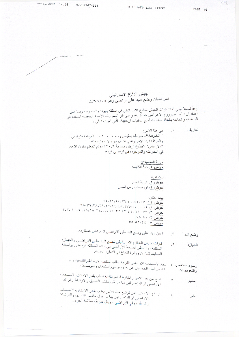
Military orders no. 66/05/T
|
Israel Defense Forces Order to Seize lands n0 66/05/T According to my authorities as a Military Chief Commander in the Region of Judea and Samaria, and as I believe that it is imperative for military reasons due to the special security situation in the region, I order the following: 1- The �¢??Map�¢?? signed in scale 1:20000 and attached to the order is an essential part of this order. The �¢??Lands�¢?? : An area of land which is 430.9 dunums, marked in red in the map : Kharbet Al Mesbah:
Beit Lqyia:
Beit Anan:
2- I announce by that the above mentioned lands are seized for military reasons 3- The IDF seize the lands and have an absolute control over it that is given to the officer of the central command officer of lands who is responsible in the ministry of defense. 4- These copies are to be given by the District Co-ordination Office �¢??The DCO�¢?? of Jerusalem to the owners of land. 5- Copies are found with maps for those who are interested in the following places :
6- Office responsible of absentee and public lands in the civil administration. 7- The owners of land have the right to go to the DCO in Jerusalem in order to get more information about their right of land use expenses and compensation. 8- The Validity of this order starts at the date signed till31/12/2007. 9- The name of this order is: Ã?¢??Order to seize lands n0 66/05/T (Judea & Samaria) 5765 – 2005. Yayer Neveah |
|
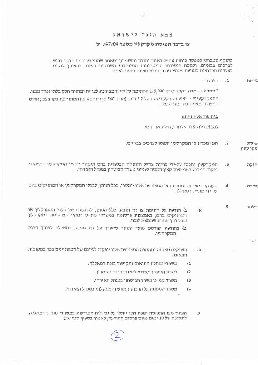
(Military orders no. 47/05/T)
|
Israel Defense Forces According to my authorities as a Military Chief Commander in the Region of Judea and Samaria, and as I believe that it is imperative for military reasons due to the special security situation in the region, I order the following: 1- The 'Map' signed in scale 1:5000 and attached to the order is an essential part of this order. The �¢??Lands�¢?? : An area of land which is 430.9 dunums, marked in red in the map : Beit 'Ur At Tahta:
2- I announce by that the above mentioned lands are seized for military reasons 3- The IDF seize the lands and have an absolute control over it that is given to the officer of the central command officer of lands who is responsible in the ministry of defense. 4- These copies are to be given by the District Co-ordination Office -The DCO- of Jerusalem to the owners of land. 5- Copies are found with maps for those who are interested in the following places :
6- Office responsible of absentee and public lands in the civil administration. 7- The owners of land have the right to go to the DCO in Jerusalem in order to get more information about their right of land use expenses and compensation. 8- The Validity of this order starts at the date signed till31/12/2007. 9- The name of this order is: Ã?¢??Order to seize lands n0 66/05/T (Judea & Samaria) 5765 – 2005. Yayer Neveah |
|
Prepared by
The Applied Research Institute – Jerusalem
ARIJ


