Introduction:
The Israeli Segregation Wall is a colonial tool used to confiscate lands, water and to prolong the occupation. It penetrates through the lands of the West Bank from its most northern tip to its deepest southern point including East Jerusalem and its villages and neighborhoods.
The length of the Wall surrounding occupied East Jerusalem is about 100 kilometers and it isolates the city from its immediate environs in the heart of the West Bank. The Wall takes a number of forms; an 8-meter-high cement blocks accompanied with a series of streets, ditches and barbwires. The other form is a succession of barbed wires that prevents access to the lands isolated behind it.
Al Isawiyeh at a glance
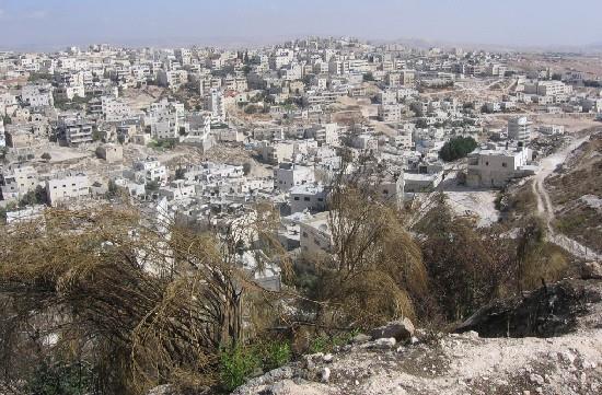
The village of Al Isawiyeh is located northeast of East Jerusalem. Its location has made it a special victim of the 1948 War as it became a border village that was designated to be a de-militarized zone under the supervision of the United Nations. The village was subjected to a long history of neglect and isolation in the fields of development and modernization as Israeli forces stationed in Hadasa Hospital and the Hebrew University block its entrances. It is worth noting that the above-mentioned institutions are heavily armed despite the fact that they are located in the de-militarized zone. See photo 1
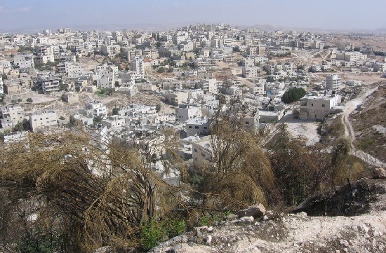
Photo 1: A general view of Al Isawiyeh village
(Photo courtesy of LRC)Photo courtesy of
The area of the village is about 12,000 dunums. Most of its current houses are built on a surface area of no more than 666 dunums. Its population in 1998 was about 8,300 Palestinians living in no more than 700 houses. The current population stands at about 11,800.
Residents of Al Isawiyeh worked in the agriculture field up until the year 1948, and as a result of the continuous siege and its close proximity to the nearby Israeli military base, most of its residents moved away from the agriculture to the labor and building sectors. There are a very limited number of university students from the village due to the fact most of them would rather to leave school and work instead of continuing their education as to face the increasing demands of life.
Al Isawiyeh and the Wall:
One of the main routes of the Wall goes through the village of Al Isawiyeh and runs parallel to the Shu'fat Jericho Road (which leads to the settlement of Maale Adumim). The Wall enters the village from its southern end where the village of Al Tur is located. It enters the village from the location of Ras Al Sheikh, to the village of Anata from the location of Al Thughra. Occupation forces have erected at the end of August 2005 a barbwire fence in the village as to mark the borders of the Eastern Ring Road that would pass on the lands of the village. Such a step was taken for security reasons according to Israeli sources. See Map

Map 1: the route of the Wall and the eastern ring road
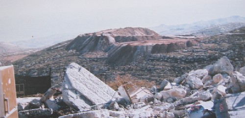
The Annexation and Expansion Wall isolates behind it more than 10,000 dunums of Al Isawiyehs best lands. As if it wasnt enough that the Eastern Ring Road did not devour enough lands from the village and prevented its eastern (and only) chance of expansion. The owners of the separated lands tried to prevent the Israeli takeover through establishing rooms and tents there and using the lands for agricultural purposes. Yet the bulldozers of the occupation forces demolished on the 18th of April, 2005 more than 20 tents and rooms in a step aimed at devouring more of the villages lands in favor of the E1 Plan A plan that aims at connecting the settlement of Maale Adumim with the other Jewish settlements surrounding East Jerusalem (see the attached Plan). If such a Plan is executed, then the remaining agricultural lands of the village will be destroyed. See Photo 2

Photo 2: a barbwire fence erected in August 2005 to mark the borders of
eastern ring road at the expnse of Isawiyeh lands
(Photo courtesy of LRC)
Devouring Al Isawiyeh Lands:
The agricultural lands of the village of Al Isawiyeh have been expropriated by Israeli occupation forces under a number of pretexts including:
-
Military and security pretexts including the establishment of a military camp.
-
Building the settlements of the French Hill and Giv'at Shapira
-
The expansion of the settlements of Mishor Adumim and Maale Adumim.
-
The establishment of by-pass roads such as the one connecting between Maale Adumim and Shu'fat (via the French Hill).
-
Expropriation under the pretext of being State Lands.
-
The building of the Hebrew University and Hadasa Hospital.
-
To be used for the General Public Benefit.!!!
-
The last pretext was the usage of the land for the purpose of establishing the Israeli segregation Wall.
The above-mentioned policy left only about 5% of the original area of the village (about 666 dunums) to be used by the Palestinians of the village !!.
The Master Plan of the Village A Tool for Building Restriction and Eviction:
In general terms, the Master Plan means the organization of the land (location, neighborhood, and city) vis-Ã -vis its population, buildings, establishments, services, land usage, streets and the basic infrastructure. The Master Plan is usually science-based and takes into consideration the future needs of the population for the upcoming 15 to 20 years, especially, in terms of population growth and its housing needs.
Given that the Israeli goal is to get rid of the Palestinian population through eviction, the best tool to achieve such a goal was to stop Palestinian building. As such, delaying the issuance of the Master Plan was a consistent Israeli policy with regard to the village of Al Isawiyeh. Palestinian homes built during the delaying period are expected to be demolished under the pretext that it was built without the proper licenses. Seventeen years have passed without placing the approval seal of the Jerusalem Municipality on any Master Plan in East Jerusalem. Today (38 years after the beginning of the Israeli occupation) some of the regions in East Jerusalem are still without any Master Plans while those areas that have Master Plans (Al Isawiyeh included) did not take into consideration the needs of the population in a number of areas including:
-
Land usage.
-
The increasing gap between the natural growth of the population and the amount of land available for them to be used for population expansion.
-
The private and Green areas.
-
The obstacles placed on house development.
A Continuous Demolition Campaign:
The location of the village of Al Isawiyeh has made it a prime target for occupation forces and authorities. As such, its lands were expropriated left and right in an attempt to veto and hamper any possible Palestinian population expansion, to allow further future expansion of the French Hill and Givat Shapira, not to hamper the implementation of the Eastern Ring Road, not to act like a buffer zone between the settlements of Maale Adumim and the French Hill in addition to not being a natural barrier for the expansion of the nearby Israeli military camp, the Hebrew University or the Hadasa Hospital. See Photo 3
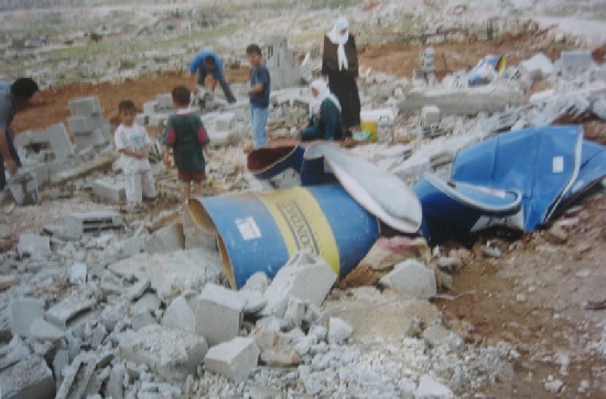
Photo 3: the ruins of the family house of Mr. Omer Mohammed Dari-
(Photo courtesy of LRC)
Following that reasoning, it was only natural that Palestinian homes in Al Isawiyeh became targets for Israeli demolishing under a number of pretexts such as what took place on January 26th, 1999 when Israeli soldiers shot dead Mr. Zaki Noor Al Dien Obied (22 years old) and injured 12 others while trying to demolish the house of Mr. Mahmoud Issa Abu Oweis. See Photo 4
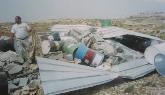
Photo 4: the ruins of the demolished house of Mr. Mohammed Mheisin
(Photo courtesy of LRC)
glimpse and an indication of the fierce campaign waged by Israel on Palestinian building in the village of Al Isawiyeh:The following statistics give a
|
No. of demolished units |
Duration |
|
27 |
From 01.01.1985- 31.12.1999 |
|
8 + 19 tens + 6 barracks |
1.1.2000-31.12..2000 |
|
15 |
1.1.2002-31.12.2002 |
|
13 |
1.1.2003-31.12.2003 |
|
2 |
1.1.2004-31.12.2004 |
|
4 |
1.1.2005-30.11.2005 |
|
Total |
69 permanent housing units + 19 tents + 6 barracks |
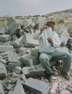
Photo 5: Mr. Mohammed Dirbas setting over the rubbles of his destroyed house(Photo courtesy of LRC)
The Effects of the Wall on the Village:
The internal migration of people living in areas set to be isolated behind the wall into the village which led to a number of results including:
1. The increase of monthly house rental due to the increase of demand.
2. The shrinking of services provided to the residents especially that the Municipality is not interested in providing services to the Arab residents, let alone those additional ones coming in from East Jerusalems suburbs. For example, there are 40 first graders to fifth graders currently without school registrations 15 of whom are first graders. Moreover, there are an additional 40 children who have reached the legal age to be in kindergarten yet they are not because they cant find a place for them.
3. The increase of student population pressure on the schools and kindergartens of the village due to the flow of new students from the nearby communities such as Al Zayyam, Al Salam Neighborhood, Anata, Dhayiat Al Barid Neighborhood and Al Ram.
4. The Wall isolates the village from its lands which was considered to be a reserve for future expansion of the village. Such isolation will force the Palestinian residents to expand vertically, rather than horizontally.
5. The Wall will deprive the residents of the village from their most fertile lands which were used in the past for agricultural and grazing purposes.
6. The isolated lands located behind the Wall have 6 animal farms that belong to Mr. Ziyad Mohammad Ali, Mr. Razi Issa Naser, Mr. Darweesh Darweesh, Mr. Ghaleb Darweesh, Mr. Mohammad Ali Naser and Mr. Adnan Sabri Darweesh.
7. The Wall isolates behind it 15 water wells and cisterns some of which are very old including the wells of Al Jourah, Al Arqoob, Harrab Oudeh, Al Hamam, Al Zanaki and Al Maskoub. Moreover, there are newer wells which were dug in the last three decades such as the well of Abdel Majeed (demolished by occupation forces), the well of Ali Mustafa, the well of Elyyan, the well of Abu Riyalah, the well of Ali Mohammad Mustafa and the well of Al Hajj.
8. The Wall deprives the village of any industrial or commercial potential as the only place that such a potential can be realized is in the eastern side of the village which is being taken over by the Wall. The western part of the village is overcrowded and, as such, is not suitable for the establishment of any future industrial zone which constitutes a major economic loss for the residents of the village and its future generations. See Photo 6
(Photo courtesy of LRC)
1. The Wall isolates behind it a number of rooms that belong to Mr. Adnan Darweesh, Mr. Mohammad Ali Nasser, Mr. Darweesh Darweesh, Mr. Razi Ahmad Issa, Mr. Ghaleb Darweesh and Mr. Ziyad Mustafa.
Prepared by
The Land Research Center
LRC


