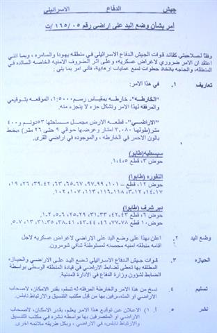
A total of 53 dunums and 400 square meters were confiscated by a military order issued last September by the commander of the Israeli army in order to establish a buffer zone around the settlement of Shavei Shomron. The targeted land (3080 meter long by 9- 26 meters wide) is located in the following areas of Nablus governorate:
-
The village of Sabastiya: Basin number 3, parcels number 5,4,1;
-
The village of An Naqura: Basin number 12, parcels number 101, 99, 97, 67, 65, 63, 42, 39, 26, 19, 17, 14, 12, 3, 118, 116, 113, 107, 102;
-
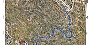
The village of Deir Sharaf: Basin number 6, parcels number 43, 42, 33, 31, 29, 25, 6, 5, 2, 1 and basin number 10, parcels number 78, 77, 46, 44, 43, 41, 38, 35, 31, 13, 7, 5. See photos No. 1 & 2

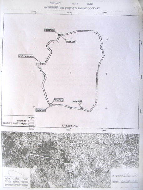
Copy of the military order and its attached map
The whole area of the target lands is registered in Taboo. According to the military order which carries the number of T/ 165/05 and its attached map, the planned buffer zone will surround the settlement from west, south west and north west . Four fence gates are, also, planned to be erected.
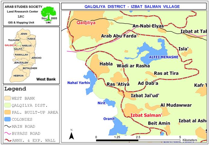
Introduction to the three affected villages:
The villages of Deir Sharaf, An Naqura and Sabastiya are located in a row to the north west of the city of Nablus, at the eastern side of the main road linking between Nablus and Jenin. Deir Sharaf's population is 2200, An Naqura's 1500 and Sabastiya's 2500. They all depend on agriculture as main income, especially olive and almond farming. See Map 1

(Location of the three villages and the settlement of Shavei Shomron)
The nucleus of Shavei Shomton settlement started in the year 1977 and after wards, it began to gradually expand over agricultural land belonging to neighboring Palestinian villages. In the year 2003, the settlement had a population of 604 settlers ( source- Foundation for Middle East Peace).
Impacts of the latest confiscation on the three villages:
1. It will separate more than 102 dunums of An Naqura agricultural lands as well as dozens of dunums of Sabastiya and Deir Sharaf lands behind the planned fence. People fear that their lands will be eventually annexed to the settlement.
2. Closing the main vital road between the governorates of Nablus and Jenin, and consequently, cutting off the geographical continuity between these two parts of the West Bank.
3. It will make it impossible for the reopening of the main entrance to the villages of Sabastiya and AN Naqura which has been closed since the beginning of the Intifada in the year 2000. Because of this situation, the people of the two villages are obliged to take another longer and costly road to reach the nearest city – of Nablus – through Wadi Bathan.
4. Depriving more than 40 families of their livelihood sources as a result of stripping them off their lands which serves as the only source of living after loosing their jobs inside Israel. Such a measure will further increase the levels unemployment and poverty.
5. There are seven houses located 3 km to the western side of the village of Sabastiya which are expected to be totally separated from the village once the fence has been set up. Lives of the occupants of these seven houses will be under constant threat as they will live inside a big prison under the mercy of the Israeli army and settlers.
Prepared by
The Land Research Center
LRC