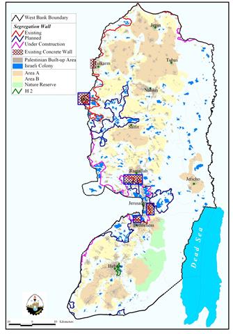
Al Jab'a village
Al Jab'a village is located 12.5 Kilometers to the southwest of Bethlehem city. It has a total area of 7120 dunums; the built-up area constitutes 150 dunums and is situated 1100 meters from the Armistice line (Green Line). Before the 1948 war, Al Jab'a used to be 7344.68 dunums mostly planted with Olive trees. It is the home of 876 inhabitants, it borders the Gosh Etzion settlement bloc and it is surrounded by the Israeli settlements of Gavaot, Bet Ain (Tsoref) and Kfar Etzion.
The Israeli threats to the village
Al Jab'a village is one of the Palestinian villages whose part of its fertile lands was confiscated during the 1948 war. After the 1967 war the village was targeted due to its location in the proximity of the green line and its mountainous topographic nature. Out of the 7120 dunums inside the village boundary of Jab'a, 666 dunums were confiscated for the construction of the Israeli settlement of Beit 'Ain (Tsoref). Since then the village was going under harsh Israeli measures such as house demolition, uprooting of trees in addition to land confiscation. Many houses in the village were demolished by the Israeli troops claiming that they were built without having building permits.
Land confiscation and razing
During the past three years, Al Jab'a has undergone a series of Israeli assaults such as on November 25, 2002; the Israeli authorities confiscated about 17 dunums of agricultural lands in Al Jab'a village southwest of Bethlehem city. Among the owners known was Musa Masha'la.
Later on, April 2003, the Israeli bulldozers razed about 98 dunums of agricultural lands and uprooted 1220 Olive, Figs and Almond trees in Al Jab'a which belong to 'Ezat 'Abed Allah, Musa Muhammad Masha'la, Nabil Ibrahim Masha'la, Muhammad Hassan At Tusy, Ibrahim Ahmad Abu Subha, Naji Masha'la, Ahmad 'Ali Hamdan and Ibrahim 'Abed El Hamed At Tusy (Volume 57, April 2003 Issue), whereby the Israeli forces handed the owners military warning preventing them from accessing their lands under the pretext of being a confiscated land.
Moreover, On September 2003, the Israeli settlers accompanied by bulldozers and tanks razed more than 50 dunums of lands planted with Olives, Vine and Almond trees in the village which belong to Abu Luha family (Latest Intifada News, 2003).
The Segregation Wall bound Al Jab'a
Today the residents of Al Jab'a are witnessing the construction of the Segregation Wall on their fertile lands. On October 17, 2004, the Israeli authorities handed the residents of Al Jab'a and the nearby Surif town (one of the towns affiliated to Hebron Governorate) military order number (T/74/04) to confiscate 270 dunums of lands (2253 meters length and 271 meters width) for the construction of the Segregation Wall. The lands threatened in Al Jab'a village are located within Block 4, in Al Khur area, whereby the lands of Surif are located within Block 3, in Wad Al Jurd and block 2, in the areas of Dhaher 'Elin, Dhaher Ader, Ras Hassan, Al Za'rura and Karnet Al Baluta.
Moreover, the Israeli Occupation Forces (IOF) handed the residents of the two villages another military order # (T/131/05) to take over 112 dunums of lands with 1,156 meters length and 100 meters width in the areas of Qurnet Ghazal, Khalet Abu Ghuneim, Wadi Abu Rish, Ein Al Biada, and Abu Tweim south of Al Jab'a village. Hundreds of dunums of Olive and Vine trees were seized or isolated behind the already constructed sections of the Wall to the west of the two villages.
Nearly 60% of Jab'a's lands will be isolated behind the Segregation Wall
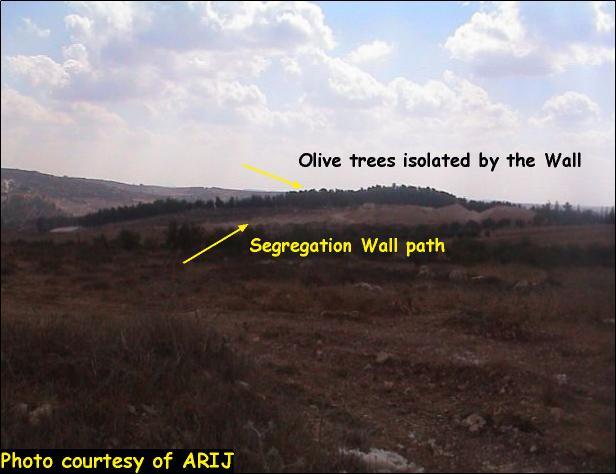
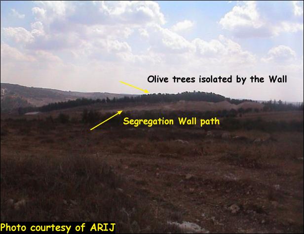
According to the updated Segregation Wall path published on February 20, 2005 by the Israeli Ministry of defense, 59% (4168 dunums) of Jab'a's lands will be isolated east and northwest of the Segregation Wall leaving only 2952 dunums for the village. 33% of the agricultural lands in the village that are cultivated with permanent crops will be isolated in addition to 91% of the permanent crops which mainly consist of Olive trees will be isolated which will severely affect the villager's economic wellbeing as they depend on agriculture as their main source of living, especially their dependence on Olive trees. See Photo 1
Moreover the forest that lies on the lands of Al Jab'a will be entirely isolated behind the Wall and the local villagers will no longer be able to access it. Also, 59% of the open space in the village will be isolated, which will impose pediments to future development of the village. Table 1 below shows the land classification inside the village boundary and the land that will be isolated behind the Wall.
Table 1: Land Use Land Cover in Al Jab'a Village
|
Land classification Land Use Land Cover
|
LULC inside the village boundary Al Jab'a |
LULC in the area isolated north and west of the Wall |
percentage of land isolated |
|
Agricultural lands |
1158 |
381 |
33% |
|
Forests |
273 |
268 |
98% |
|
|
|
|
|
|
Open spaces with little or no vegetation |
4807 |
2823 |
59% |
|
Permanent crops |
392 |
356 |
91% |
|
Palestinian Urban fabric |
150 |
|
|
|
Jewish settlement |
340 |
340 |
100% |
|
|
|
|
|
|
Total |
7120 |
4168 |
59% |
Source: ARIJ database- GIS, 2005
New military orders and a trade passage in the area
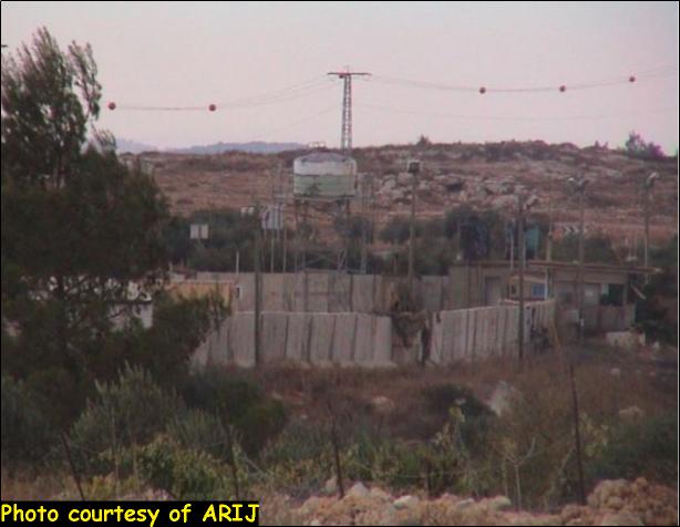
In continuation of the land confiscation process in the Palestinian territory, the Israeli authorities issued on August 22, 2005, two new military orders stipulating the confiscation of 181 dunums of lands. According to the first military order which carries the number of (T/158/05) a total of 110 dunums of lands mostly planted with Olives are to be confiscated in Al Jab'a and the nearby village of Surif at favor of transferring the existing Al Jab'a checkpoint into a trade passage, 43 dunums of lands are to be taken from Al Jab'a village, 64 dunums from Surif and the rest 3 are located inside the Armistice Line (Green Line). See Photo 2 & Photo 3 of Al Jab'a Checkpoint of Al Jab'a Checkpoint of Al Jab'a Checkpoint & of Al Jab'a Checkpoint

The lands threatened of confiscation in Al Jab'a village are located within Block '2': Marh Al Ful area and Block '4': Al Khur area which belong to the families of Abu Latifa, Abu Luha, Abu Hamdan and At Tus, whereby the lands in Surif are located within Block '2': in the areas of Khalit Muhammad Salameh. See Photo 4 & Photo 5 &


While, the second military order # (T/132/05), will confiscate 71 dunums of lands according to the analysis performed by ARIJ's Geographical Information System- GIS unit in contradiction with the number stated in the Israeli military order which was 68 dunums of land at a length of 740 meters and an average width of 100 meters in the areas of Al Hebala, Abu Tweim and Wad Al Khanzer at favor of constructing new parts of the Segregation Wall in the village. See Map 1
Al Jab'a re-oriented southwards
Traditionally, Al Jab'a village is considered one of the villages affiliated to Bethlehem Governorate. Today the village became entrapped between the Segregation Wall and the Israeli bypass road # 367 with a width of 10km that links Gosh Etzion bloc with cities inside Israel. B'Tselem in their report 'Forbidden Roads', classified this road as a 'partially prohibited road' on which Palestinians are allowed to travel only if they have special movement permits. This permit is called 'Special Movement Permit' at internal Checkpoints in the West Bank' (Lein, 2004).
Residents of Al Jab'a used to drive through this road which connects them to road number 60 that leads to Bethlehem and the nearby villages. If the Wall is implemented the residents will no longer have access on it and the village will be totally cut off from Bethlehem governorate, which means that the village residents will not be able to go to their work, schools, universities, hospitals and to the healthcare centers, which will force residents to use other longer alternative roads through the towns of Surif, Beit Ummar, Al 'Arrub camp, Beit Fajjar, Tequ', Za'tara bypass road and then to Bethlehem city. As a result the link between Jab'a and the governorate will be weakened, while taking alternative routes will cost the resident more money and time as in the first place the road to Bethlehem city was 18 Km but now due to the construction of the Wall the road to Bethlehem will be 26 Km.
The Segregation Wall north of Al Jab'a is constructed to grab the entire Gosh Etzion settlement bloc. This bloc will encompass an area of 72,223 dunums. See Map 2 & Table 2 below shows the Israeli settlements of Gosh Eztion which surrounds Al Jab'a village. & Table 2 below shows the Israeli settlements of Gosh Eztion which surrounds Al Jab'a village.
Table 2: Israeli settlements of Gosh Eztion bloc which surrounds Al Jab'a village
| No | SettlementName | Date ofEstablishment | Population | Area inKm2 |
| 1 |
Kfar Etzion |
1967 | 517 | 0.93 |
| 2 |
Allon Shevut |
1971 | 3229 | 1.00 |
| 3 |
Betar Illit |
1985 | 24895 | 4.69 |
| 4 |
Efrat |
1979 | 7273 | 2.18 |
| 5 |
Elazar |
1975 | 993 | 0.54 |
| 6 |
Gav'aot |
1984 | 120 | 0.13 |
| 7 |
Hadar Betar |
1978 | 30 | 0.06 |
| 8 |
Neve Daniyyel |
1982 | 1,225 | 0.58 |
| 9 |
Rosh Zurim |
1969 | 302 | 0.89 |
| 10 |
Tzurif |
1989 | 646 | 0.69 |
| 11 |
Migdal Oz |
1977 | 327 | |
|
|
Total |
39557 | 11.69 |
Source: ARIJ database- GIS, 2005
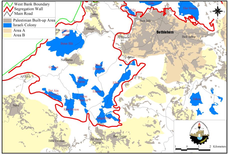
Map 2: The Segregation Wall around Gosh Etzion Block and Al Jab'a village
Conclusion
The Israeli Segregation Wall in the Occupied Territory has been designed to ensure the Israeli control over large areas of the West Bank, and has been followed with the aim of preventing the emergence of a Palestinian state. The policy of land confiscation to construct the Segregation Wall has always been a major threat to Palestinian lands which in turn shows a critical plan of keeping the West Bank areas inaccessible and disconnected.
References
Palestinian National Information Centre, (2003). Latest Intifada news. Retrieved 09 16, 2003, from http://www.pnic.gov.ps/arabic/quds/arabic/news/2003/2003_09/alaqsa_intifada169.asp.
Lein, Y. (2004). Forbidden roads: the discriminatory west bank road regime . : B'Tselem.
'Volume 57, April 2003 Issue.' ARIJ Monthly Report on the Israeli Colonization Activities in the West Bank. 2003. Applied Resaerch Institute-Jerusalem (ARIJ). 10 Oct. 2005 http://www.arij.org/paleye/monthley/April-03/index.htm#Bethlehem.
Prepared By
The Applied Research Institute – Jerusalem
ARIJ