Introduction:
Qibya and Budus are small Palestinian villages located approximately 32 kilometers (20 miles) northwest of Ramallah city. Lands of the two Villages are mostly cultivated with Cactus and old Roman olive trees where more than 75% of the villages' populations depend on them as a major source of income in addition to their dependence on livestock.
Budrus and Qibya village locations:-
A- Qibya village;the village of Qibya also spelled (Kibya, or Qibiya) is located 30 kilometers to the northwest of Ramallah city, its built up area is approximately one kilometer from the Armistice line and reaches up approximately 200 meters above the see level.
The village houses a total population of 4761 inhabitants according to the Palestinian Central Bureau of Statistics (PCBS) 2005 and constitutes a built up area of 660 dunums (0.66km. It is bordered by Shuqba village from the northeast, Shibteen village from the east and Budrus village from the southwest.
B) Budrus village; a small Palestinian village located 33 kilometers to the northwest of Ramallah city and approximately 0.5 kilometers from the Armistice line. It has a total population of 1461 inhabitants according to the Palestinian Central Bureau of Statistics (PCBS) 2005, where the built-up area occupies about 240 dunums (0.24km) of the village's total area (3107 dunums). It is bordered by Al Qibya village from the northeast, Ni'ilin village from the southeast and the Armistice line from the west. Table 3 details the land use of Qibya and Budrus villages
The Israeli Segregation Wall in Qibya and Budrus villages
During the 1948 war, Israel confiscated 68% from the two villages' lands for military purposes. Today, the construction of the Segregation Wall has contributed much to the confiscation of additional agricultural lands from the remaining areas. Table 1 and Table 2 below show the total number of lands confiscated by Israel between the years 1948 and 2005. (See table 1 & 2 and map one)
|
Table one: Lands confiscated from Qibya and Budrus villages between the years 1948 and 2005. |
|||||
|
Village |
Area in 1948 (before the war)(Dunums) |
Land confiscated in 1948 (Dunums) |
Percent (%) |
Land remained today (Dunums) |
Percent % |
|
|
|
|
|
|
|
|
Qibya |
16407 |
11684 |
71% |
4723 |
29% |
|
Budrus |
7879.23 |
4771.57 |
61% |
3107.66 |
39% |
|
|
|
|
|
|
|
|
Total |
24286.23 |
16455.57 |
|
7830.66 |
|
Source: ARIJ GIS Database 2005
Table one above shows that 71% of Qibya's village lands were confiscated following the 1948 war. The village today is left with a small area (4723 dunoms)that is barely enough for future expansion. The construction of the Segregation Wall is also taking more lands from the village, totally disconnecting it from its surroundings and limiting the natural growth of the village. While Budrus village, lost about 60% of its agricultural lands following the 1948 war, an area that contributed much to the decline of the village's living conditions. The wall also confiscates and isolates a considerable area (8169 dunoms) of Budrus village as detailed in Table 2 below:
|
Table two: lands confiscated from Qibya and Budrus villages for the construction of the Segregation Wall |
|||
|
Village |
Original area (Dunums) |
Lands lost for the Wall (Dunums) |
Percent (100%) |
|
|
|
|
|
|
Qibya |
4723 |
54.5 |
1.15 % |
|
Budrus |
3107 |
8169 |
38 % |
Source: ARIJ GIS Database 2005

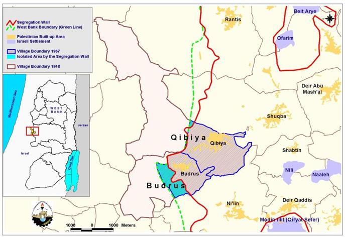
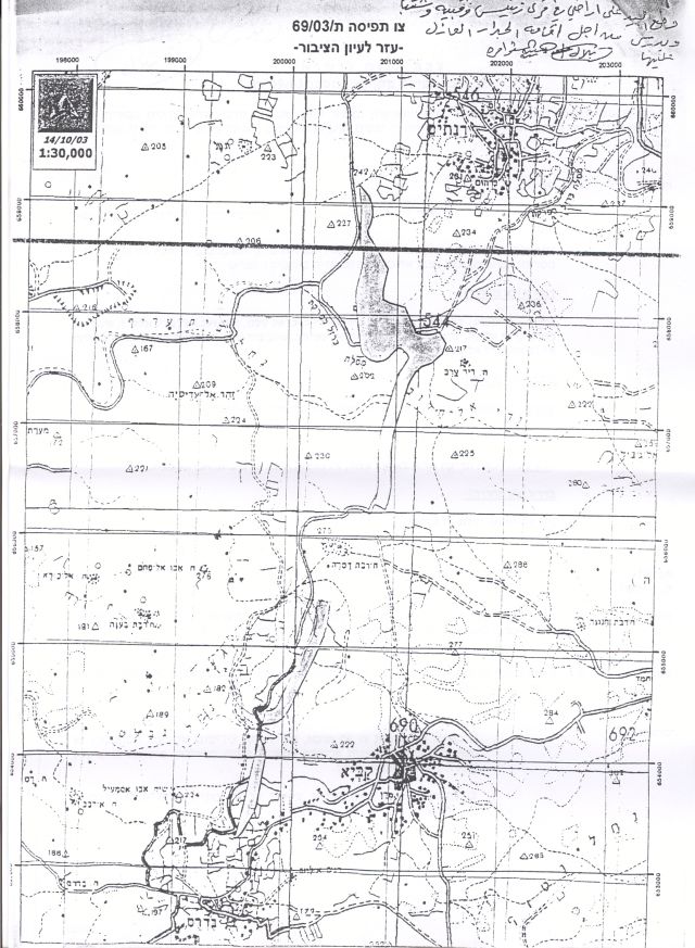
Map 1: Location of Budrus and Qibya Villages
The Segregation Wall in Qibya
On October 14, 2003, the Israeli occupation forces handed out residents of Qibya village military order number (69/03/T Judea & Samaria, 2003) which stipulates the confiscation of 140 dunums (0.14 km) from Qibya village lands. A thorough analysis of the military order at ARIJ GIS (Geographical Information system) unit showed that an additional 54.5 dunums of agricultural lands were threatened of isolation once the Wall is completely constructed in the village.
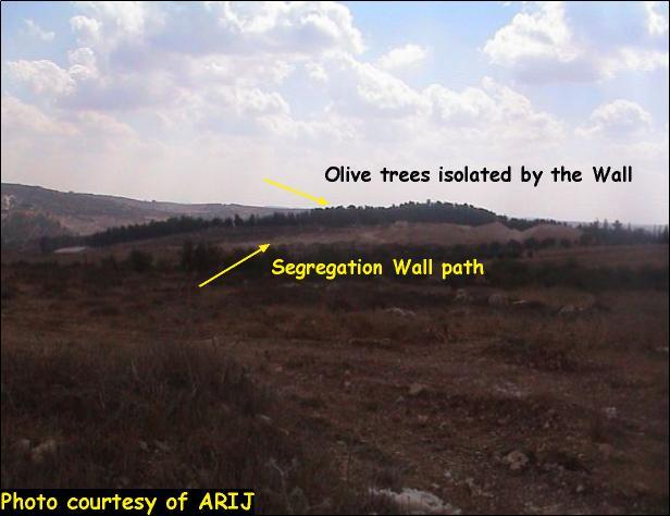
Today, the Wall is visible on lands of Qibya village and isolates vast areas of lands behind it. The isolated lands are mostly cultivated with Olive trees in addition to the 200 olive trees that have been uprooted while constructing the Wall. The total length of the Wall in Qibya village is 1.7 km; out of which, 0.4 km (400 meters length) penetrating inside Qibya village while the remaining 1.3 km Wall is constructed along the Armistices line (the Green Line). See photo 1 and read translation of military order in Appendix One. and read translation of military order in Appendix One.
The Segregation Wall in Budrus
The Israeli forces didn't stop at that far, but served another military order on August 25, 2004 to the nearby village of Budrus, military order number (42/04/T Judea and Samaria 2004) which stated the confiscation of 45.6 dunums (0.045km) of agricultural lands for constructing another segment of the Segregation Wall in the village that will extend towards the northern, the western and southwestern parts of the village.
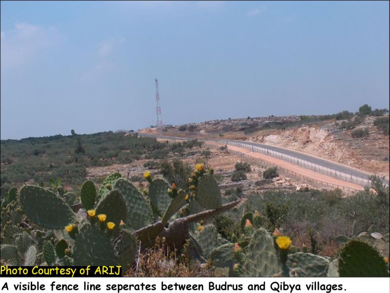
Today, as one enters Budrus, a visible fence appears to cut the village from its extension. A total of 8169 dunums (8.169 km) of agricultural lands are already segregated behind the Wall. Looking at the satellite image of Budrus one can notice that most of the cultivated area will be isolated behind the Wall and thus will be off limits to the local villagers who depend on agriculture as their main means of living. It is worth mentioning here that the total length of the Wall in Budrus village is 1.6 km; out of which, 1.11 km of the Wall is constructed along the Armistices line (Green Line). Table 3 below details the land use/ land cover of the lands segregated by the Wall in Budrus village.
|
Table three: Land use/Land cover in Budrus village |
|||
|
land classification |
LULC of the Village (in dunoms) |
LULC of the lands isolated by the wall |
LULC of the Lands left east of the Wall. |
|
Area in dunums |
|||
|
Arable land |
388 |
1,023 |
635 |
|
Open spaces |
30,882 |
3,442 |
2,744 |
|
Forest |
3,704 |
3,704 |
0 |
|
|
|
|
|
|
Total |
34,974 |
8,169 |
3,379
|
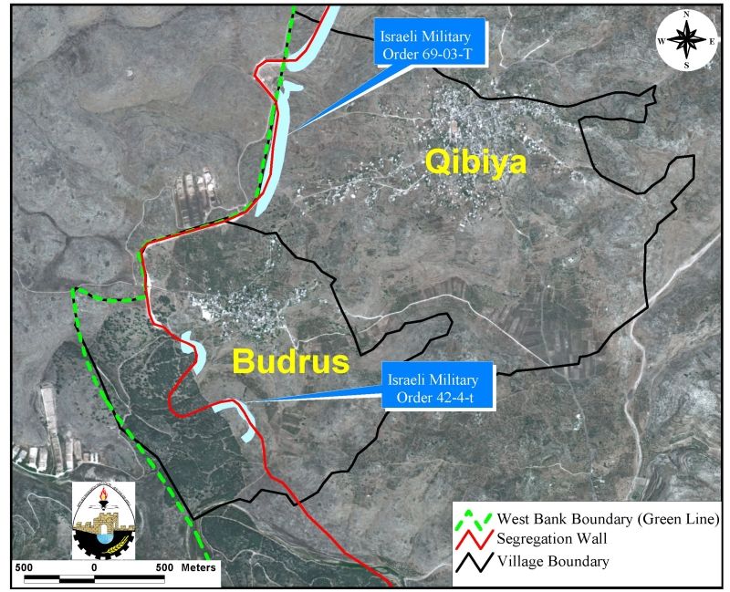
Map 2: Map of military orders in Budrus and Qibya Villages
(Translation of the military orders in Appendix two)
The impacts of the Segregation Wall on Qibya and Budrus villages:
Not only has the Segregation Wall caused destruction to the agricultural lands but also lead to the the uprooting of hundreds of Olive trees estimated at 500 Olive trees, 200 in Al Qibya village and 300 in Budrus village and the isolation of 791 dunoms of the most fertile agricultural lands. This Israeli measure has caused a decline in the two villages' economy in that they are mostly dependent on Olive cultivation and olive oil production. The Wall has also limited Villagers' access to the villages' open spaces and grazing areas and led to the extinction of animal breeding which is considered as a secondary source of income in the two villages.
The wall violates international law and human rights
The construction of the Segregation Wall by Israel inside the Occupied Palestinian Territory violates international law and is a blatant violation to human rights. It has severe consequences on the lives of thousands of Palestinians in that it imposes restrictions on their movements within the territory they live in and causes major violations of their fundamental rights, including the right to an adequate standard of living, the right to work, to food, to medical care, and to education.
The International Covenant on Civil and Political Rights (ICCPR) – Property (ICCPR, article 1): All peoples have the right of self-determination. By virtue of that right they freely determine their political status and freely pursue their economic, social and cultural development.
The International Covenant on Economic, Social and Cultural Rights (ICESCR) – Food (ICESCR, art. 11): The States Parties to the present Covenant recognize the right of everyone to an adequate standard of living for himself and his family, including adequate food, clothing and housing, and to the continuous improvement of living conditions. The States Parties will take appropriate steps to ensure the realization of this right, recognizing to this effect the essential importance of international co-operation based on free consent.
The Hague Regulations expressly forbids an occupying power 'to destroy or seize the enemy's property, unless such destruction or seizure be imperatively demanded by the necessities of war' (Article 23).
Article 53 of the Fourth Geneva Convention is also clear in that: 'any destruction by the Occupying Power of real or personal property belonging individually or collectively to private persons, or to the State, or to other public authorities, or to social or cooperative organizations, is prohibited, except where such destruction is rendered absolutely necessary by military operations.'
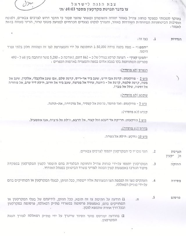
Appendix one
|
|
|
|
|
Israel Defense Forces Order to Seize lands n0 69/03/T
According to my authorities as a Military Chief Commander in the Region of Judea and Samaria, and as I believe that it is imperative for military reasons due to the special security situation in the region, I order the following:
1- The 'Map' signed in scale 1: 50000 and attached to the order is an essential part of this order. The 'Lands' : An area of land which is 862 dunums, (5280 meter long and 68_490 meters wide) marked in red in the map :
2- I announce by that the above mentioned lands are seized for military reasons. 3- The IDF seize the lands and have an absolute control over it that is given to the officer of the central command officer of lands who is responsible in the ministry of defense. 4- These copies are to be given by the District Co-ordination Office 'The DCO' of Ramallah to the owners of land. 5- Copies are found with maps for those who are interested in the following places :
6- The owners of land have the right to go to the DCO in Ramallah in order to get more information about their right of land use expenses and compensation. 7- The Validity of this order starts at the date signed till, 31/12/2005. 8– The name of this order is: Order to seize lands n0 69/03/T (Judea & Samaria) 2003.
Mosheh Kaplenski
|
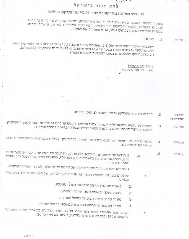
Appendix two
|
|
|
.jpg)
|
Israel Defense Forces Order to Seize lands n0 42/04/T
According to my authorities as a Military Chief Commander in the Region of Judea and Samaria, and as I believe that it is imperative for military reasons due to the special security situation in the region, I order the following:
1- The 'Map' signed in scale 5000: 1 and attached to the order is an essential part of this order. The 'Lands' : An area of land which is 45.6 dunums, (312 meter long and 62 meters wide) marked in red in the map :
2- I announce by that the above mentioned lands are seized for military reasons. 3- The IDF seize the lands and have an absolute control over it that is given to the officer of the central command officer of lands who is responsible in the ministry of defense. 4- These copies are to be given by the District Co-ordination Office 'The DCO' of Ramallah to the owners of land. 5- Copies are found with maps for those who are interested in the following places :
6- The owners of land have the right to go to the DCO in Ramallah in order to get more information about their right of land use expenses and compensation. 7- The Validity of this order starts at the date signed till, 31/12/2005. 8– The name of this order is: Order to seize lands n0 42/04/T (Judea & Samaria) 2004.
Mosheh Kaplenski
|
References:
Arij databases. Arij archives. 18 Oct 2005
Geneva Convention . Geneva: International Committee of The Red Cross, 1958.
International Covenant on Economic, Social and Cultural Rights. Geneva: Office of the High Commissioner for Human Rights, 1966.
International Covenant on Civil and Political Rights. Geneva: Office of the High Commissioner for Human Rights, 1966.
Marrar, Ayeed . Personal interview with Budros village council. 2 June 2005.
'Projected Mid-Year Population For Ramallah and Al Bireh Governorate by Locality 2004-2006.' Palestinian Central Bureau of Statistics. 18 Oct. 2005 http://www.pcbs.gov.ps/populati/pop07.aspx..
Prepared By
The Applied Research Institute – Jerusalem
ARIJ