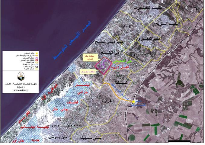
To the northwestern part of Jerusalem city lies the Palestinian village of Beit Duqqu and is located 17 km away from it. It is linkedto Jerusalem by a 3 km long – road which also connects it with the main Highway – Road number 443.
The village's topographic relief is mountainous and is 650 meters above sea level. It is surrounded by Beit 'Anan from the southwest, Beit Izja from the southeast, At Tira from the north and Al Qubeibeh from the south. See map 1

Beit Duqqu's total land area is 7000 dunums including the Built-up area and houses a population of 1,553 according to the Palestinian Central Bureau of Statistics PCBS, 2005. Seven major clans constitute the population of Beit Duqqu, they are: Ali Hassan, Marrar, Rayan, Daoud , Bdar, Bdwan and Abu Aid). Figure one below shows the increase of the village's population over the years. See Table 1
Table 1: Increase of Beit Duqqu's Village population over the years
|
Year |
population |
|
1922 |
245 |
|
1945 |
420 |
|
1967 |
438 |
|
1987 |
865 |
|
1996 |
1206 |
|
2003 |
1459 |
|
2005 |
1553 |
Source: State Information Service
Beit Duqqu is famous for cultivating apricot, olive and Vine where most of the residents depend on agricultural as a main source of living.
General social services:-
The village has two elementary schools one for females accommodating 240 students and another for males accommodating 190 students, in addition to one kinder Garden. Four different clinics (primitively equipped) are run by four nurses and four doctors who come once a week for few hours to provide medical services to the village. While the village lacks rehabilitation centers, ambulances and specialized clinics that should provide the village with the urgent health services. There are no recreational centers in the Palestinian community of Beit Duqqu, except for one small youth club and a women society.
Beit Duqqu village and the Israeli settlements:
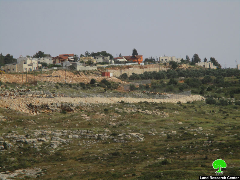
Today, the village of Beit Duqqu is surrounded by a number of illegal Israeli settlements from its eastern and northeastern parts, a detail of these settlements is stated in table two below. See table two
| Table two: Israeli Settlements east of Beit Duqqu | ||||
| Location from Beit Duqqu village | Total Area 2004(dunoms) | Population (year 2004) | Date Founded | Settlements Name |
| Northeast of Beit Duqqu village. | 2840 | 10,635 | 1982 | Giv'at Ze'ev |
| Northeast of Beit Duqqu village. | 330 | 825 | 1977 | Beit Horon |
| North of Beit Duqqu village. | 274 | NA | 1977 | Beit Horon B |
| 3,444 | 11460 | Total | ||
Source; ARIJ & PEACENOW
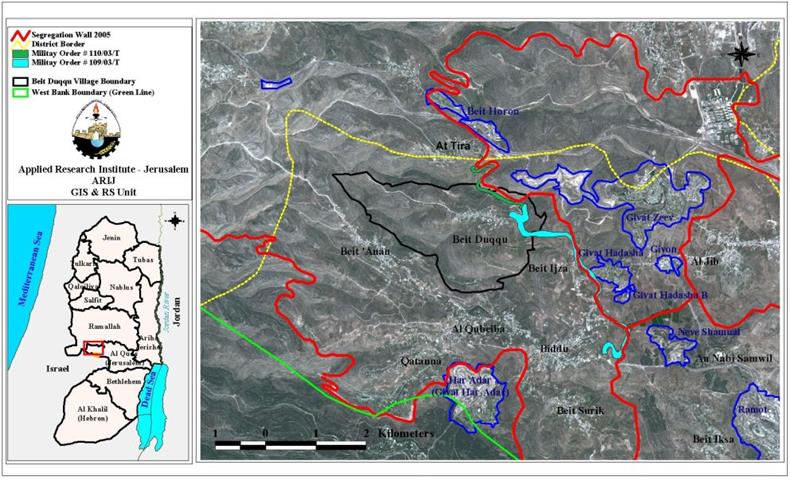
The Segregation Wall in Beit Duqqu Village
In June 2002 the Israeli government started with the construction of the Segregation Wall in the West Bank. As part of the Wall that surrounds Jerusalem, the so called Jerusalem Envelope, the villages northwest of Jerusalem started receiving military orders in September 2002 stating the confiscation of their lands for Wall constructions.
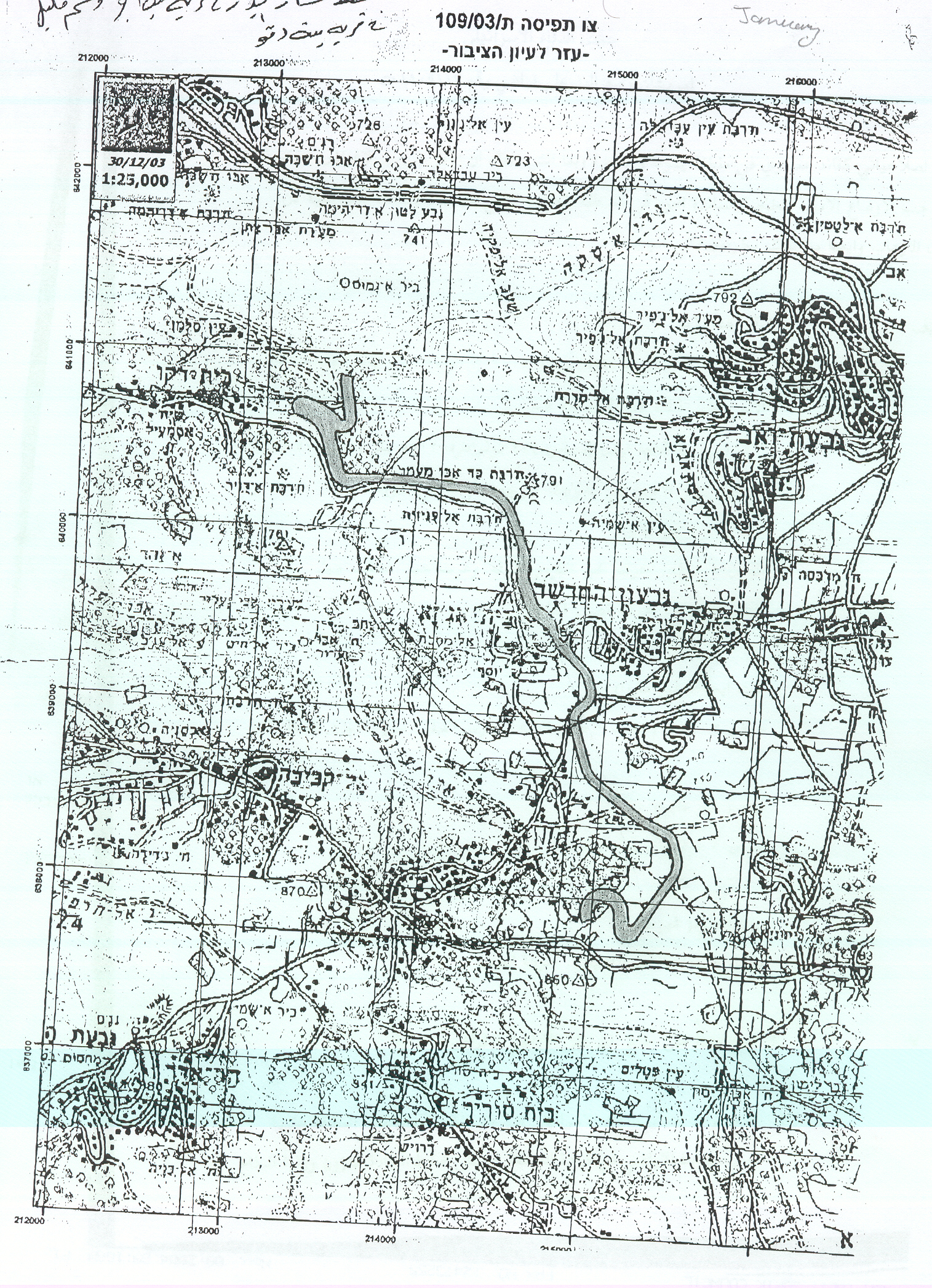
On December 30, 2003, the Israeli occupation forces handed out villagers of Beit Duqqu two military orders numbered (109/03/T and 110/03/T Judea& Samaria 2003) which targeted the northern and southeastern parts of the village. According to the military orders, a total of 478 dunums (0.478 km²) will be confiscated and another 430 dunums (0.43 km²) of the agricultural lands will be isolated behind the Wall once it is fully constructed. The length of the wall in Beit Duqqu is 2.14 km, starting from the north of the village, bordering At Tira village to the north of Beit Duqqu and then stretches to the east confiscating more open and cultivated spaces, and continues to the south towards Beit Ijza. The following table shows the total number of military orders that were served to Beit Duqqu village. See table three and translations of the military order in annex 1 and 2.
|
Table three: military orders served to Beit Duqqu village in 2003 |
|||||
|
Date |
Number of military order |
Land confiscated (Dumoms) |
Land isolated (Dumoms) |
Total length (Km) |
Location |
|
December 30, 2003 |
109/03/T |
334 |
260 |
1.14 |
East of the Beit Duqqu village |
|
December 30, 2003 |
110/03/T |
144 |
170 |
1 |
North of the Beit Duqqu village |
|
Total |
478 |
430 |
2.14 |
||
See map 1: Map of military orders
Villagers of Jerusalem's northwestern villages raised petitions to the Israeli High Court demanding the rerouting of the Segregation Wall and moving it to the Green Line. The Israeli High Court issued its ruling on the 29 June 2004 (few days before the International Court of Justice ruling in Hague) to reroute a section of 30 km of the Wall in nine Palestinian villages north and northwest of Jerusalem city including Beit Duqqu.
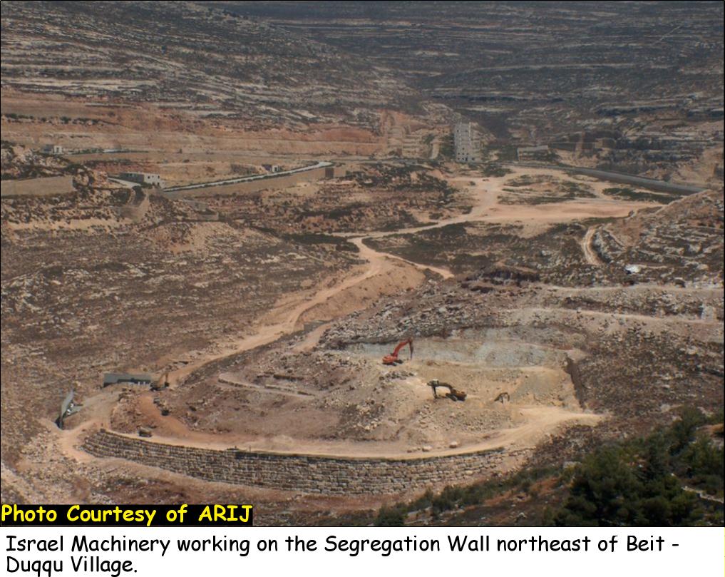
A map of an updated Wall route was published on the IDF (Israeli defense Forces) website on June 30, 2004 stating a change in the Wall route in the affected Palestinian villages. According to this map the Wall will stretch for 1.37km, confiscate 82 dunums (0.082km²) and isolate another 290 dunums (0.29km²). See Photo 1 & Photo 2 &

 c
c
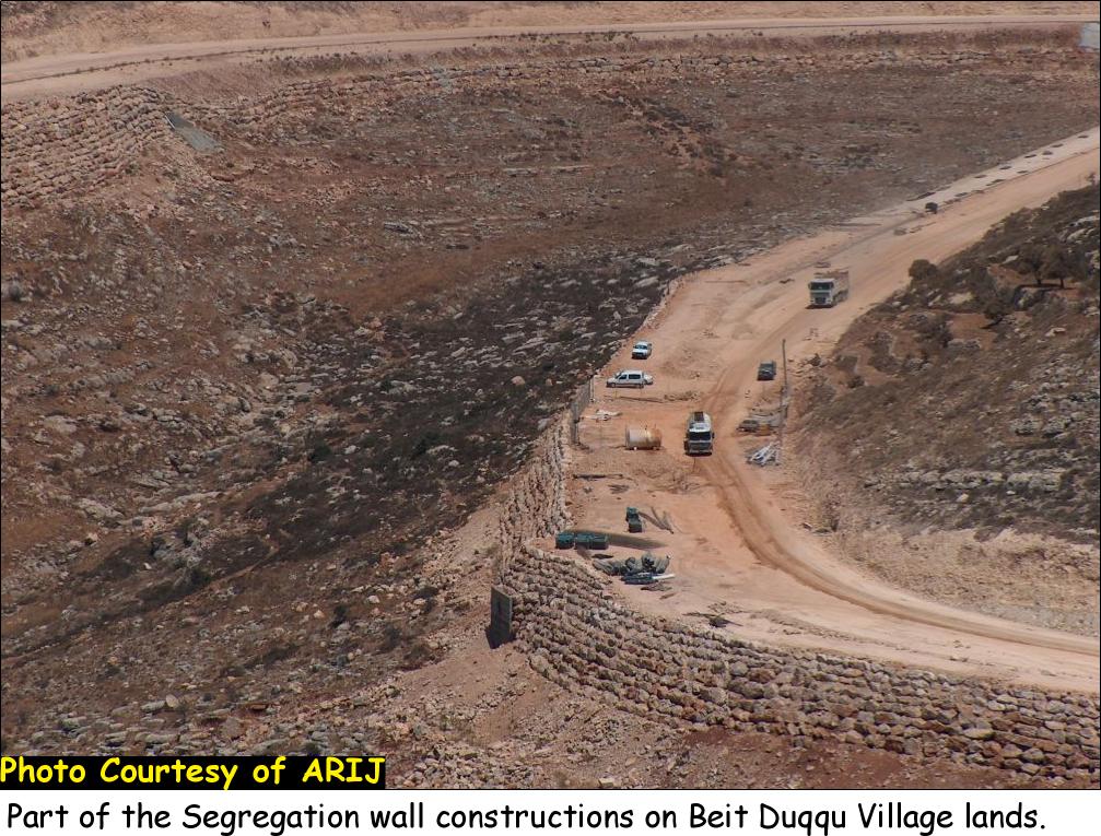
On February 20, 2005, the Israeli Ministry of defense issued an updated plan of the Segregation Wall in the West Bank which included changes in the Wall route in the Middle and southern Governorates. Villages located north and northwest of Jerusalem, including Beit Duqqu, witnessed a change in the Wall route. In the case of Beit Duqqu, the new Wall route will stretch for a length of 0.7 kilometers on its lands from the north and northeastern parts of the village and will isolate about 64 dunums (0.064 km) from the village's lands. Later in July 2005, the Israeli bulldozers resumed wall constructions in the northeastern part of Beit Duqqu village according to the updated Wall map that was issued by the Israeli Ministry of Defense on February 2005. See photo 3 & Photo 43 &

The effects of the Segregation Wall on Beit Duqqu village:
The construction of the Segregation Wall will lead to the confiscation of two natural springs in the village used for agricultural purposes. The springs will be totally isolated once the construction of the Wall is totally completed and villagers of Beit Duqqu will no longer be able to use these two springs.
Conclusion:
The erection of The Segregation Wall is one of long termed Israeli plans of land grab Policies and control over the Palestinian Territory. If the Israeli government wants to be separated from the Palestinians and intends to build a wall for that purpose it should have constructed that wall on the green line instead of constructing it in the heart of the West Bank.
The construction of the Segregation Wall is a blatant violation of International laws and conventions and UN resolutions which do not permit the annexation of land by force and protects the rights of people under occupation as stated by Geneva Conventions, article 47: 'Protected persons who are in occupied territory shall not be deprived, in any case or in any manner whatsoever, of the benefits of the present Convention by any change introduced, as the result of the occupation of a territory, into the institutions or government of the said territory, nor by any agreement concluded between the authorities of the occupied territories and the Occupying Power, nor by any annexation by the latter of the whole or part of the occupied territory'.
Article 46 of the Hague Convention (Laws and Customs of War on Land (Hague II); July 29, 1899).Prohibits the confiscation of private property in occupied territory. Therefore, the confiscation of land by the Israeli government for construction of the Segregation Wall is a blatant violation to International laws and Conventions.
Annex 1
Military order no. (109/03/T Judea & Samaria 2003):
|
|
|
Israel Defense Forces Order to Seize lands n0 109/03/T According to my authorities as a Military Chief Commander in the Region of Judea and Samaria, and as I believe that it is imperative for military reasons due to the special security situation in the region, I order the following: 1. The ''Map'' signed in scale 1: 20000 and attached to the order is an essential part of this order. The ''Lands'' : An area of land which is 334 dunums(5502 meter long and 50-80 meters wide) marked in red in the map :
2. I announce by that the above mentioned lands are seized for military reasons 3. The IDF seize the lands and have an absolute control over it that is given to the officer of the central command officer of lands who is responsible in the ministry of defense. 4. These copies are to be given by the District Co-ordination Office ''The DCO'' of Ramallah to the owners of land. 5. Copies are found with maps for those who are interested in the following places :
6. The owners of land have the right to go to the DCO in Ramallah in order to get more information about their right of land use expenses and compensation. 7. The Validity of this order starts at the date signed till 31/12/2005 8. The name of this order is: ''Order to seize lands n0 109/03/T (Judea & Samaria) 2003.
Mosheh Kaplenski
|
Annex 2
Military order no (110/03/T Judea and Samaria, 2003):
|
Israel Defense Forces Order to Seize lands n0 110/03/T According to my authorities as a Military Chief Commander in the Region of Judea and Samaria, and as I believe that it is imperative for military reasons due to the special security situation in the region, I order the following: 2. The ''Map'' signed in scale 1: 5000 and attached to the order is an essential part of this order. The ''Lands'' : An area of land which is 144 dunums(2140 meter long and 25-55 meters wide) marked in red in the map :
6. I announce by that the above mentioned lands are seized for military reasons 7. The IDF seize the lands and have an absolute control over it that is given to the officer of the central command officer of lands who is responsible in the ministry of defense. 8. These copies are to be given by the District Co-ordination Office ''The DCO'' of Ramallah to the owners of land. 9. Copies are found with maps for those who are interested in the following places :
9. The owners of land have the right to go to the DCO in Ramallah in order to get more information about their right of land use expenses and compensation. 10. The Validity of this order starts at the date signed till 31/5/2005 11. The name of this order is: ''Order to seize lands n0 110/03/T (Judea & Samaria) 2003.
Mosheh Kaplenski
|
Population data for the years 1922, 1954, 1967 and 1987 are from the Palestinian State Information Service (SIS) while population data for the years 1996, 2003 and 2005 are from the PCBS
Prepared By
The Applied Research Institute – Jerusalem
ARIJ