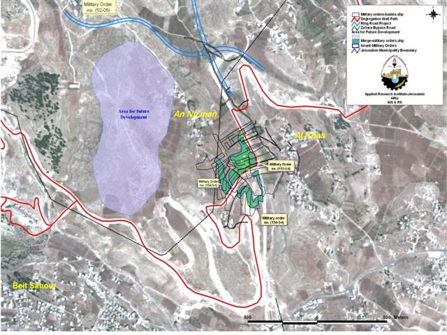
The Israeli occupation forces handed out residents of Al Khas and Al Nu39;man on September 3, 2005 four new military orders to confiscate lands for military purposes, mainly to construct a trade passage on lands of An Nu39;man village, to construct two new related roads and a third road that will lead to Har Homa settlement. The military orders hold numbers (#156-5-T), (# 154-5-T), (# 155-5-T) and (52-05) and state the confiscation of 43 dunums of Al Khas, Al Nu39;man villages and Kherbit Mazmuria lands for the Segregation Wall path. Below is a detailed table of the three military orders.
Table 1: Details of the military orders in Al Khas and Al Nu39;man
|
Military order # |
Dunums confiscated |
Block # |
Community |
purpose |
|
(154-5-T) |
9 dunums |
13 |
An Nu'man village |
Military purposes, to construct a road that will lead to Al Nu'man village. |
|
(155-5-T) (1, 2 & 3) |
30 dunums |
13 |
An Nu'man Village |
Military purposes and to construct a trade passage |
|
|
|
13 |
Beit Sahour |
|
|
(156-5-T) (1, 2 & 3) |
4 dunums |
13 |
An Nu'man Village |
Military purposes, mainly to expand Mazmuria passage and to construct a road to Al Khas area. |
|
|
|
13 |
Beit Sahour |
|
|
(52-05) |
|
|
Kherbit Mazmuria |
To construct 1.14 km road leading to Har Homa settlement. |
|
Total |
43 |
|
|
|
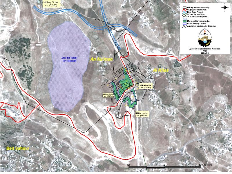
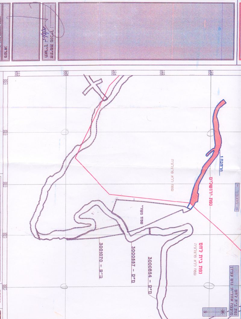
Map 1: Map of military orders .
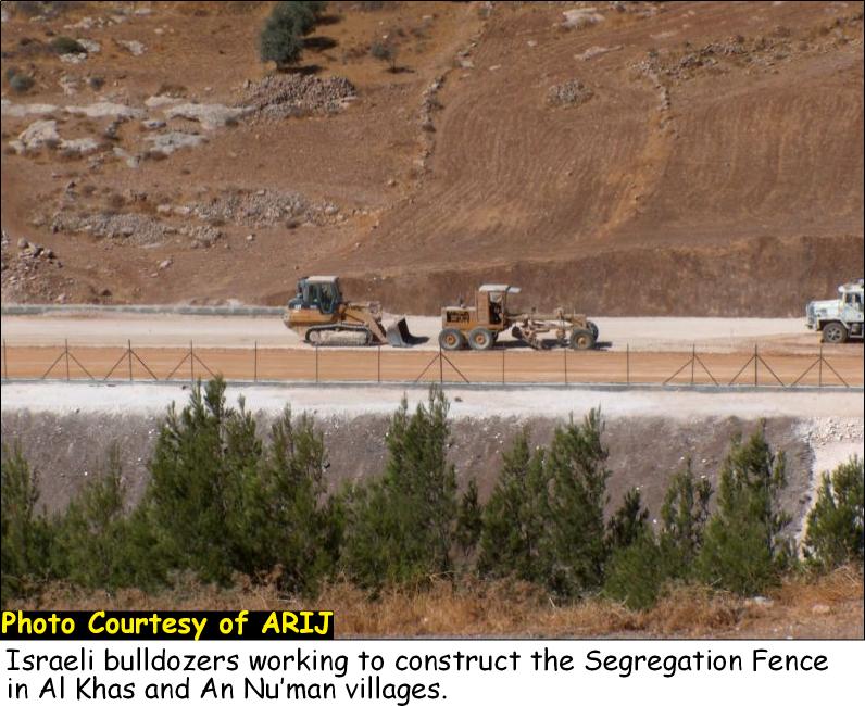
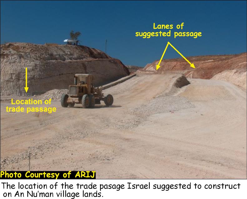
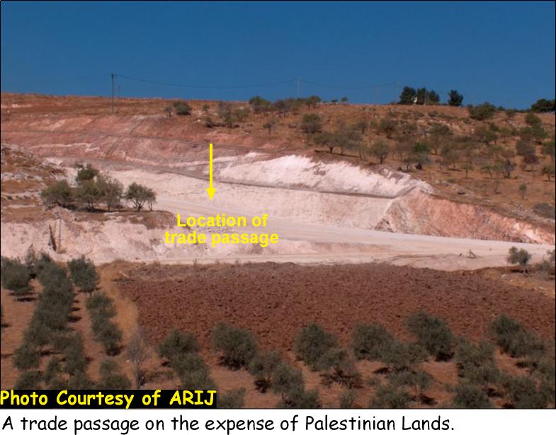
A field visit to the site clearly identified the location of the four military orders being implemented on Al Khas and Al Nu39;man lands as the Israeli bulldozers were working on the site a months earlier of the issuance of the military orders. The orders are complementary to the Israeli Segregation Wall plan which is being implemented on lands of the three communities (Al Khas, An Nu39;man and Kherbit Mazmuria). See Photo 1 & Photo 2

Solidifying the Segregation Wall as a Border
According to military order # (155-5-T), Israel plans to construct a terminal or trade passage on the area segregated by the construction of the wall and adjoining the wall path. The terminal is one of the five Terminals (or passages) Israel announced in December 2004 to set up within the path of the Segregation Wall to control the movement of Palestinian citizens and goods in the West Bank. The five terminals are Mazmuria in Bethlehem, Tarqumia in Hebron, Al Jalameh in Jenin, Sha39;ar Ephraim in Tulkarem and Betunia in Ramallah. See Photo 3 & Photo 4

Israel had also asked the World Bank that time to finance the construction of these terminals but the plan was met with rejection because three of the terminals, Mazmuria is one, lie within the boundaries of the West Bank and come to solidify the Segregation Wall as a border that penetrates inside the West Bank and is not located on the Armistice Line (Green Line).
In September 2005, Israel named 10 main terminals in the West Bank in addition to 23 crossing points along the path of the Segregation Wall (Haaretz newspaper, Sep.9, 2005). The ten terminals included the previously named five terminals in addition to Hasam Tzahub in the upper Jordan valley, Terminal 300 in Bethlehem, Shu39;fat, Az 39;Ayyem and Qalandyia in Jerusalem. The ten terminals are to control the movement of more than 2 million Palestinians once they39;re fully constructed. Five of these terminals will be trade terminals under the bases of back to back goods exchange; these are Tarqumia, Al Jalameh, Mazmuria, Sha39;ar Ephraim and Betunia in Ramallah. These terminals are to control all the trade exchange between the West Bank, Israel and the rest of the world.
Roads, the Israeli answer to contiguity!
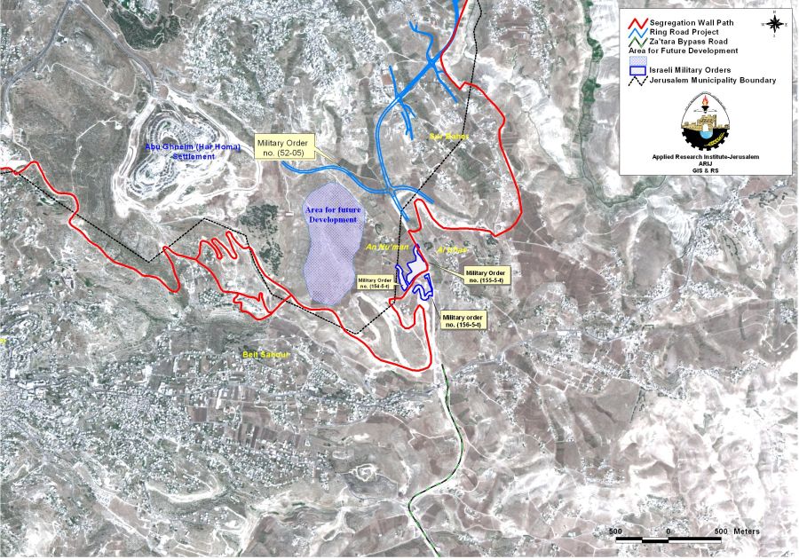
Military order # (154-5-T) stated the construction of 0.26 km length road to the south of Al Nu39;man village which will connect the village39;s main road with the path of the wall and confiscate 9 dunums of land from An Nu39;man village. Further analysis of the military order showed that the planned road is an extension to a future settlement construction that is planned to be constructed in the open space between Abu Ghneim Settlement and the western parts of An Nu39;man village. The construction of the new Israeli settlement was proposed by the Israeli Jerusalem municipality in its Master plan (Jerusalem Master Plan 2000) which indicated plans for two new Israeli settlements in the vicinity of Har Homa settlement, one to the southeast and another to the northwest. Those two new settlements, according to the plan, will occupy an approximate area of 1080 dunums. See map 2: Area of Future development.

Following Israel39;s announcement of constructing the Segregation Wall in An Nu39;man village in 2003, the village was subjected to various Israeli practices that aimed at cutting them off from their village and depriving them of their right to life, liberty, security and property.
The Israeli Occupation forces blocked off the passage through the main road leading to the village. The Bulldozers razed and destroyed the infrastructure of the main road leading to the village making it impossible for vehicles to come into or out of the village. Pedestrians also had to go down a deep ditch in order access the other side of the road. Residents sought other outlets to access the nearest center for services and work.
Villagers appealed through an Israeli lawyer to the Israeli court regarding their situation and managed afterwards to open the road back to its usual track. Constructions in the wall started and continued till the date of this article. The path of the wall is becoming a visible line that cuts through the village of An Nu39;man and separates it from the nearest community 'Al Khas', causing more difficulties to its residents as they try to enter or exit the village. Residents are no longer able to access the main road where the wall is lining up the area and are hunting for dusty and longer routes to access their destinations.
Lately, villagers of An Nu39;man were informed by the Lawyer that the Issuance of the military order # (154-5-T) will enable the implementation of the earlier envisioned plan by the Jerusalem Municipality; added to it that the Israeli practices to close off the road were made on purpose, mainly to maintain control on the area through the establishment of the trade passage and the construction of the new settlement (the extension to Har Homa settlement); consequently, confiscating as much lands as possible from the village while depriving Palestinians their lands and properties.
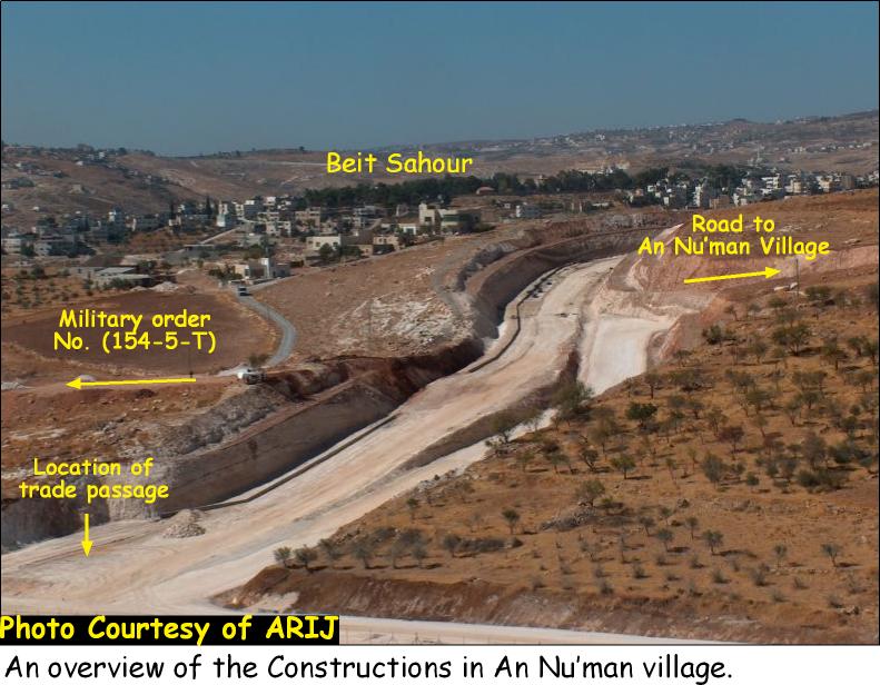
Another military order and map numbered (52-05) were served to villagers of Al Nu39;man on August 17, 2005 stating the construction of a new road to the north of An Nu'man village that will lead to Har Homa (Abu Ghneim) settlement. The Israeli bulldozers had already lined up the path of the road which also connects to the under-construction wall. See Photo 5 and map of the military order. and

The road, according to the map, will stretch a length of 1.14 kilometers on An Nu39;man village lands and Kherbit Mazmuria and will separate the village's built-up area from the Olive yards extending to the north east of the village and are considered the main source of income for the villagers.
A thorough analysis of the military order also showed that the road Israel plans to construct, is complementary to an Israeli plan called the39;Ring Road Project39; which Israel announced about in 1996 and aims at circulating the city of Jerusalem with a number of roads and connecting the Israeli settlements in the southern part of Jerusalem with those in the north, as well as connecting Jerusalem39;s settlements with the Israel39;s coastal area. Part of the Ring Road project will cut through An Nu39;man39;s built up area and will cause the demolition of a number of houses in the area in addition to tightening the siege on the remaining houses. Nine other houses located to the south of An Nu39;man village are put in an enclave due to wall and bypass road constructions. The wall circulates the nine houses from the north, the west and the south; while the bypass road will, once it is completed, will close the remaining opening in the east and deprive residents39; access to village itself and to the nearby community of Al Khas, See map 3

Military order number (156-5-T) states the confiscation of 4 dunums of land for constructing a road that will connect with the road leading to the nine Palestinian houses enclaved by the Wall and with the announced Mazmuria Passage. The fact that the Israelis are trying to make access easier to the nine houses doesn't cancel the fact that the nine Palestinian houses will always be imprisoned by the wall and the bypass road and will totally lose contact with the surroundings. The Road is more to serve the Israeli vision in the area rather than serving the residents themselves. It furthers aims at depopulating the area from its residents, bringing the history back to life.
The Ring Road Project
The Ring Road project consists of Roads 5 and Road 45. It is finalized by the Israeli Mariah company (Jerusalem Development Company) and originates from the main Hebron-Jerusalem road at the southern entrance of Talpiyot and extends eastwards to reach Al Sawahreh Ash Sharqiyeh village, passing through the northern edges of Sur Bahir. It then continues northwards passing through Anata lands to later cross Ramallah-Jerusalem Road. The road further extends to the north, passing through the agricultural lands of many Palestinian villages in the Jerusalem and Ramallah districts such as Jaba39;, Bit 'Ur At Tahta, Beit 39;Ur Al Fuqa, Saffa and Bal39;in to finally reach at the Beit Shemen Junction in the coastal area of Israel near Ben Gurion airport. See map 4 of the Ring Road Project
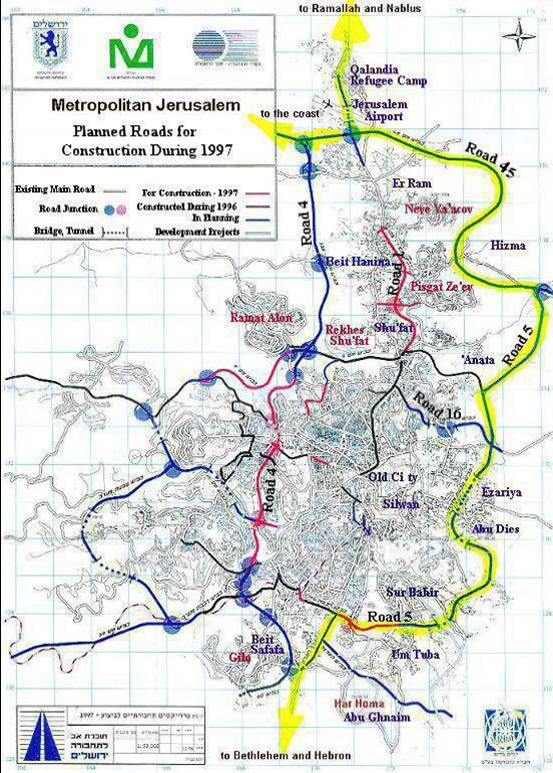
The road plan also includes three tunnels, the largest of which is 1.8 kilometers in length which will pass under Abu Dis village, emerging near Az Z'ayyem village. A second tunnel will pass under the Jerusalem airport and connect with the main Jerusalem-Ramallah road.
The current status of the Segregation Wall on lands of Al Khas & Al Nu39;man.
Following the decision of Israel39;s Ministerial Committee for Security Matters to construct the Segregation Wall throughout the West Bank in 2002, hundreds of military orders were issued stating the confiscation of lands for this purpose. Constructions have been accelerated since that time and the Wall has been erected alongside the western parts of the West Bank, and penetrating inside. It is becoming one huge and visible structure, cutting off Palestinian communities from their lands and threatening their existence.
The Wall in Al Khas & Al Nu39;man villages is part of the Jerusalem envelope Plan (The Wall around Jerusalem) which is going to stretch 190 km around Jerusalem, and will pave the way illegally for future prospect to redefine the Jerusalem municipal boundary once again.
Altogether, 283 dunums of land are segregated by the construction of the Segregation Wall in Al Khas and An Nu39;man Villages and carves 3.44 km through the two communities, cuts them off from each other, from their lands and from Jerusalem. The wall is in its final stages where an arbitrary line now divides the Palestinian families of the two villages that used to live few minutes walk from each other, and is eating up much of their lands with its wide structure. People going few meters down the road from An Nu39;man village to access the road going to Al Khas village are no longer able to use this road due to the difficulties caused by the construction of the wall. Today, the wall totally closes the main road between the two villages and residents of An Nu39;man village have to go through longer and time consuming routes, in order to access their destinations. Students particularly face difficulties as they go to the only school in Al Khas village every morning. The current route residents (including students) of An Nu39;man village have to take is almost 3 km length (from An Nu39;man Village to Al Khas Village passing through Beit Sahour main Road) instead of 0.5 km road which directly goes from An Nu39;man to Al Khas.
Constructions of the wall continue and residents of An Nu39;man village suffer from the constant movement changes imposed on them by the construction of the wall and obstructing their access to the nearby Palestinian Communities.
Further Israeli plans entitled by the Construction of the Segregation Wall
As part of the Israeli plans in the area of Al Khas and An Nu39;man, Israel plans to establish a new military base on 84 dunums piece of lands already segregated by the line of the Wall. This military camp, according to the Israeli maps, is going to replace the military camp already situated in the southeast of Beit Sahour city and is locally known as 'Ush Ghrab or 39;The nest of the Raven39;.
Old military orders for Wall constructions:-
In July 2003, the Israeli authorities served out military orders to residents of Al Khas and Al Nu39;man to confiscate 136 dunums of their agricultural lands to start constructing the Segregation Wall. The military order commenced the second stage of Phase one of the Segregation Wall around Jerusalem or the so called 39;Jerusalem Envelope'.
Later in September of the same year (2003), the Israeli occupation forces distributed another military order to residents of An Nu39;man village declaring the confiscation of another piece of land estimated at 47 dunums for military purposes. This pretext turned out later to be for constructing an additional part of the Segregation Wall, which will isolate the village from its neighboring village Al Khas.
Segregation With bypass Roads…
In September 2003, villagers of Al Khas and Al Nu39;man received military orders to confiscate 100 dunums of agricultural lands from the two villages to construct a bypass road of 1.2 km length and 160 meters width alongside the Segregation wall. The path of the new bypass road, according to the military order, will link Za39;atra bypass road, which was constructed earlier in February 2003 over Palestinian lands, with Al Nu39;man village main road (already closed by the construction of the wall), to reach Har Homa Settlement (Abu Ghneim) in the north, and connect it with settlements located in the south-eastern part of Jerusalem city such as Gush Etzion Bloc. See Photo 6
The Israeli harassments in Al Khas and An Nu39;man
Following the 1967 war, the village of An Nu39;man was declared as part of Israel39;s Unilateral Jerusalem Municipal borders despite that, its residents hold Palestinian ID cards. Villagers were denied services throughout the previous years by the Israeli authorities such as banning their children from attending the nearest school in the neighboring village of Sur Baher claiming that the school is only reserved for residents of Jerusalem (those who hold Jerusalem ID cards).
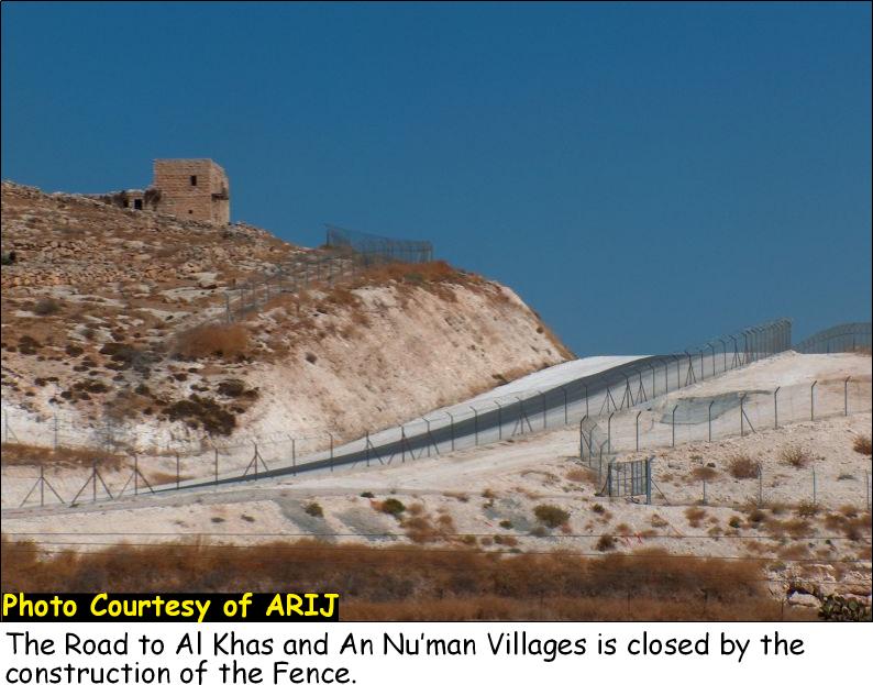
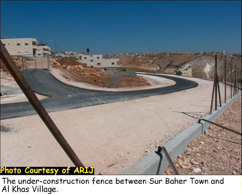
Today, the village of An Nu39;man is disconnected from Sur Baher town by a separation fence with barbed wires on each side of the fence. The fence also extends upwards to the lands of Al Khas village where also a fence with the same structure added to it one deep trench on one of its sides to prevent Palestinians of the two villages from accessing the Jerusalem passing through Sur Baher town which is 10 minutes away from them. Such Israeli action has directly affected the economic sector of the village since many villagers depended on work inside Israel. See Photo 7, Photo 8 & Photo 9, &


Israeli practices and International law
The systematic nature of Israel39;s occupation policies (including the construction of the Segregation Wall) submits it to a further violation to the Human Rights and international law. Israel39;s military occupation in the Occupied Palestinian Territory (OPT) comprise a crime of apartheid according to the International Convention on the Suppression and Punishment of the Crime of Apartheid (1973). The Convention defines apartheid as: 39;the imposition of various legislative measures on different racial groups while injuring the rights of one. Moreover, the crime of Apartheid comprises a 39;crime against humanity39; and 39;a serious threat to international peace and security.
It is also a flagrant violation of international humanitarian law, specifically The Hague Regulations of 1907 and the Fourth Geneva Convention of 1949:
-
The Hague Regulations expressly forbids an occupying power 39;to destroy or seize the enemy39;s property, unless such destruction or seizure be imperatively demanded by the necessities of war39; (Article 23).
-
The Fourth Geneva Convention, the primary document of international law governing instances of military occupation, states in Article 49 that:39;The occupying power shall not deport or transfer parts of its own population into the territories it occupies.39;
-
Article 53 of the Fourth Geneva Convention is also clear that: 39;any destruction by the Occupying Power of real or personal property belonging individually or collectively to private persons, or to the State, or to other public authorities, or to social or cooperative organizations, is prohibited, except where such destruction is rendered absolutely necessary by military operations.39;
-
The appropriation and destruction of Palestinian land is an especially serious violation of the Fourth Geneva Convention, Article 147 of which clearly prohibits, ''extensive destruction and appropriation of property, not justified by military necessity and carried out unlawfully and wantonly.39;39; Violations of Articles of the Fourth Geneva Convention constitute grave breaches of the Convention and should be prosecuted as War Crimes.
The wall also imposes disproportionate and discriminatory restrictions on the movement of Palestinians within the territory itself and deprives them their rights to work, to education and to an adequate standard of living. Article 11 of the International Covenant on Economic, Social and Cultural Rights also states the rights of everyone 39; to an adequate standard of living for himself and his family, including adequate food, clothing and housing, and to the continuous improvement of living conditions39; which Israel denies by the construction of the Wall and the confiscation of Palestinian Lands.
Article 13 of the International Covenant on Economic, Social and Cultural Rights states that the [The States Parties to the present Covenant] agree that education shall be directed to the full development of the human personality and the sense of its dignity, and shall strengthen the respect for human rights and fundamental freedoms. They further agree that education shall enable all persons to participate effectively in a free society, promote understanding, tolerance and friendship among all nations and all racial, ethnic or religious groups, and further the activities of the United Nations for the maintenance of peace39;.
Related Links
-
New Israeli tenders to expand Har Homa (Abu Ghneim) settlement
-
Al-Khas and Al Nu'man villages suffocated by the Israeli colonization
-
Al-Khas and Al-Nu'man villages between the jaws of occupation
Prepared By
The Applied Research Institute – Jerusalem
ARIJ


