• About The Project
  • Palestine in Century
  • Selected Maps
  • Glossary
  • About ARIJ
  • About LRC
  • By Year
    • Case Studies By Year
    • Daily Report By Year
Tuesday, June 2, 2026
POICA
No Result
View All Result
  • Home
  • Settlements
    • New Israeli Settlements
    • Settlement Expansion
  • Israeli Violations
    • Agriculture
    • Confiscation
    • Demolition
    • Environment
    • Eviction of Palestinians
    • Settlers Attacks
  • Bypass Roads
  • Israeli Plans
  • Segregation
    • Checkpoints
    • Closure
    • Separation Plans
  • Military Orders
  • Reports
    • Daily Report
    • Monthly Report
    • Quarterly Report
No Result
View All Result
POICA
No Result
View All Result

Real Israeli intentions disclosed
“Palestinian lands separated behind the Wall are targeted by confiscation”

March 9, 2017
in Military Orders
Real Israeli intentions disclosed  “Palestinian lands separated behind the Wall are targeted by confiscation”

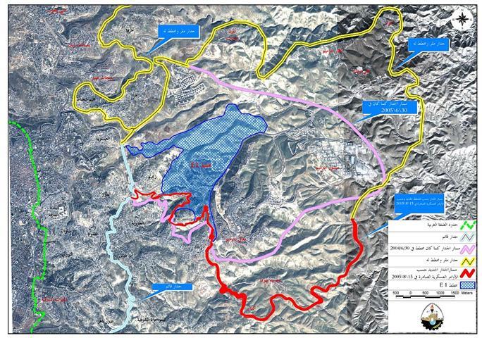
In continuation of the land confiscation process in the West Bank, the Israeli army issued three new military orders stipulating the confiscation of 14.47 dunums to construct roads in the lands separated behind the Segregation Wall in three villages in Qalqiliya district. The orders were issued on July 18, 2005, by the commander of the Israeli army – central command, Ya'ir Neve. The military orders stated that the confiscations were done for security and military purposes, that is, to open roads between the existing Israeli settlements and the Wall as followed:

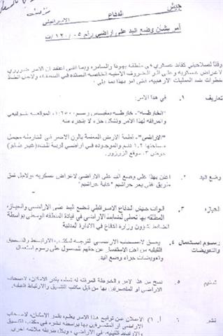
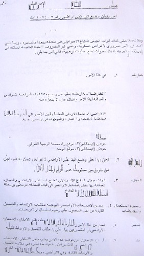
1.     Military Order number T/120/05: stipulates the confiscation of 1.2 dunums from Kafr Thuluth lands, basin number 3, the area of Az Zarzur (located between Izbat Salamn and Izbat Jal'ud) for the purpose of constructing a road to link the Israeli settlement of Nirit inside the Green Line with the Palestinian lands separated behind the Wall; See photo 1: copy of military order No. T/120/05.

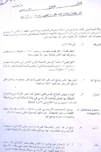
2.     Military Order number T/121/05: stipulates the confiscation of 9.2 dunums from Habla lands, basins number 7640 and 7641 (located between Ras Atiya and Izbat Jal'ud for the purpose of constructing a road to link the Israeli settlement of Nahal Yarhiv inside the Green Line and the Palestinian lands separated behind the Wall. See photo 2: copy of military order No. T/121/05.

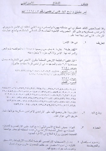
3.     Military Order number T/107/05 stipulates the confiscation of 4,07 dunums from Mas-ha lands, basins number 2 and 3, for the purpose of constructing a road between the Israeli Settlement of Etz Efrayim near the village of Siniriya and the Wall. See photo 3: copy of military order No. T/107/05.T/107/05

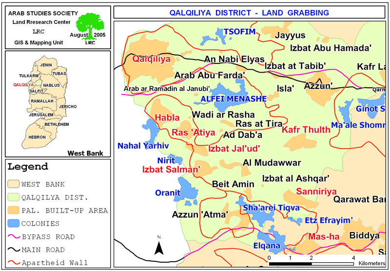
Not forgetting to mention that the total land area separated behind the Wall from the above mentioned Palestinian villages is 6566 dunums. See Map 1

Impacts of the Israeli Military orders on Palestinian lands:

1. The opening of the roads will damage the targeted lands in two ways: Firstly, the lands will be devastated under the path of the proposed roads; secondly; once these roads have been established, security zones will be announced along both sides of the roads where no body will be allowed entry.

2.  Once the Israeli Settlements are connected to the lands behind the Wall, it will facilitate the annexation of this land into the settlements and expedites the Israelization process at the expense of Palestinian property.

3.  The opening of the proposed roads will link the existing settlements with each others and with Israel. It will, also, make these settlements ready for horizontal expansion, and probably, new Israeli settlements under new names will be established at the separated Palestinian lands, given the fact that a new settlement usually starts with a new road.

Disclosure of real intentions:

This Israeli measure came two weeks after the burning of thousands of dunums of Palestinian agricultural lands behind the Wall in Tulkarem district (for related information, see case study ' Separated Palestinian lands are now targeted by fire ', August, 2005.  It also came after the issuance of a number of military orders last year and this year barring Palestinian building and use of land at a depth of 150 meters along the eastern bank of the Wall path (see copies of the attached orders numbers 05/05 5763-2000 and S/05/05 ).

 
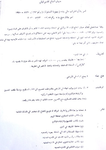
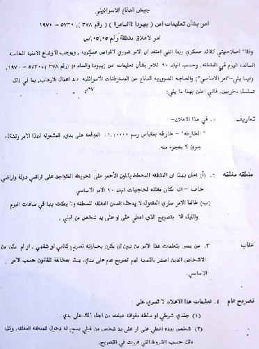
 Photo 4 & 5: copies of military orders No. (05/05 5763-2000) and (S/05/05)) and ()

It seems that the Israeli occupation authorities have openly and defiantly started to uncover their real intentions behind setting up the Wall: to grab more Palestinian lands and annex them into Israel. This, once again, proves the trueness of warnings extended by Palestinians to the whole world that the real aim behind constructing the Segregation Wall was not security as Israeli pretends, but, to confiscate as much lands as possible.

It, also, invalidates the wrong notion that the Wall is a border line between the Palestinian and Israeli states. It is simply a nonstop process of land seizure, annexation and expansion. 

It is worth mentioning that the victims had objected the orders to the Israeli government's legal advisor but the legal advisor's answer was negative under the pretext that 'the roads are planned to be built for security and military purposes and the Israeli law, international law as well as military laws allowed such things to happen'.


Prepared by
The Land Research Center
LRC


Recommended For You

سلطات الاحتلال الإسرائيلي بصدد الاستيلاء على موقع قبر النبي صموئيل شمال غرب مدينة القدس

by arij
May 23, 2026
0
سلطات الاحتلال الإسرائيلي بصدد الاستيلاء على موقع قبر النبي صموئيل شمال غرب مدينة القدس

 نشرت سلطات الاحتلال الإسرائيلي في الثامن عشر من شهر أيار من العام 2026 اعلانا مفاده الاستيلاء على الأراضي الفلسطينية في قرية النبي صموئيل شمال غرب القدس المحتلة. وجاء...

Read moreDetails

إقامة منطقة عسكرية عسكرية داخل أراضي (أ) في جنين

by arij
May 19, 2026
0
إقامة منطقة عسكرية عسكرية داخل أراضي (أ) في جنين

   في السابع من شهر أيار من العام 2026، وزعت سلطات الاحتلال الإسرائيلي أمرا عسكريا جديدة على أهالي مدينة جنين يقضي بمصادرة 7.2 دونما من الأراضي الفلسطينية في...

Read moreDetails

“بمساحة اجمالية 177 دونما من أرضي البيرة وبيتين”, طريق استيطاني لخدمة البؤر الاستيطانية في محافظة رام الله

by arij
May 18, 2026
0
“بمساحة اجمالية 177 دونما من أرضي البيرة وبيتين”, طريق استيطاني لخدمة البؤر الاستيطانية في محافظة رام الله

في الحادي عشر من شهر أيار من العام 2026, نشرت دائرة أراضي إسرائيل اعلانا جديدا يقضي بمصادرة المزيد من الأراضي الفلسطينية في محافظة رام الله لأغراض استيطانية في...

Read moreDetails

“في خدمة مستوطنة ناحال حيلتس”, طريق استيطاني إسرائيلي جديد على أراضي بتير وبيت جالا في محافظة بيت لحم

by arij
May 18, 2026
0
“في خدمة مستوطنة ناحال حيلتس”, طريق استيطاني إسرائيلي جديد على أراضي بتير وبيت جالا في محافظة بيت لحم

تواصل سلطات الاحتلال الإسرائيلي إحكام سيطرتها على المزيد من الأراضي الفلسطينية في الضفة الغربية المحتلة، وهذه المرة من خلال استهداف أراضي محافظة بيت لحم. ففي السادس والعشرين من...

Read moreDetails

مناطق نفوذ المستوطنات ودورها في إعادة تشكيل الجغرافيا الفلسطينية

by arij
April 23, 2026
0
مناطق نفوذ المستوطنات ودورها في إعادة تشكيل الجغرافيا الفلسطينية

أصدرت سلطات الاحتلال الإسرائيلي في العاشر من شهر نيسان 2026 الكراسة رقم (273)، وهي وثيقة تضم مجموعة من المناشير والأوامر والتعيينات الإسرائيلية المتعلقة بالجوانب الأمنية والعسكرية والإدارية، إضافة...

Read moreDetails
Next Post
شارون يعزز استيطان الضفة الغربية مقابل انسحاب غزة  إصدار أوامر عسكرية لجدار الفصل حول معاليه أدوميم

شارون يعزز استيطان الضفة الغربية مقابل انسحاب غزة
إصدار أوامر عسكرية لجدار الفصل حول معاليه أدوميم

LATEST NEWS

سلطات الاحتلال الإسرائيلي بصدد الاستيلاء على موقع قبر النبي صموئيل شمال غرب مدينة القدس

سلطات الاحتلال الإسرائيلي بصدد الاستيلاء على موقع قبر النبي صموئيل شمال غرب مدينة القدس

by arij
May 23, 2026
0

........................................................

إقامة منطقة عسكرية عسكرية داخل أراضي (أ) في جنين

إقامة منطقة عسكرية عسكرية داخل أراضي (أ) في جنين

by arij
May 19, 2026
0

........................................................

الآثار كأداة للضم الزاحف: مشروع القانون الإسرائيلي لإعادة هندسة الجغرافيا والهوية في الضفة الغربية

الآثار كأداة للضم الزاحف: مشروع القانون الإسرائيلي لإعادة هندسة الجغرافيا والهوية في الضفة الغربية

by arij
May 23, 2026
0

........................................................

النكبة الفلسطينية في ذكراها الثامنة والسبعين: من التطهير العرقي إلى الإبادة وإعادة هندسة الجغرافيا الفلسطينية 

النكبة الفلسطينية في ذكراها الثامنة والسبعين: من التطهير العرقي إلى الإبادة وإعادة هندسة الجغرافيا الفلسطينية 

by arij
May 18, 2026
0

........................................................

flag_yellow_lowEU-PfP-Logo

This website and its content were initiated in 1993 by the Applied Research Institute – Jerusalem (ARIJ) and the Land Research Center (LRC) with the support from the European Union up until 2023. Since then, the Applied Research Institute – Jerusalem (ARIJ) has taken over the continued development and maintenance of the website. The views expressed remain solely those of ARIJ) and do not necessarily reflect those of the European Union.

© 2026 Copyright | ARIJ | All Rights reserved.

No Result
View All Result
  • Home
  • Settlements
    • New Israeli Settlements
    • Settlement Expansion
  • Israeli Violations
    • Agriculture
    • Confiscation
    • Demolition
    • Environment
    • Eviction of Palestinians
    • Settlers Attacks
  • Bypass Roads
  • Israeli Plans
  • Segregation
    • Checkpoints
    • Closure
    • Separation Plans
  • Military Orders
  • Reports
    • Daily Report
    • Monthly Report
    • Quarterly Report

© 2026 Copyright | ARIJ | All Rights reserved.