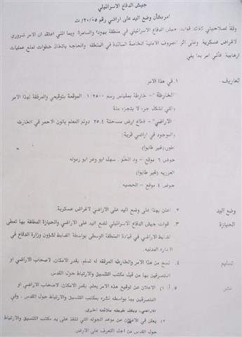
A new land confiscation order was issued by the commander of the Israeli army in the West Bank, General Moshe Kepliniski, calling for the seizure of 25.4 dunums of Palestinian owned lands in Al 'Eizariya (Bethany) for the purpose of constructing the Segregation Wall and a main crossing point.
The military decree, which was issued on February 12th, 2005, carried the number of T/20/05. The targeted lands are located in basin number 6 (Wadi al Ham, Sahel Abu Wa'ar and Abu Ramula) and basin number 4 (Al Hadba). About 40 Palestinian families will be affected by this order.
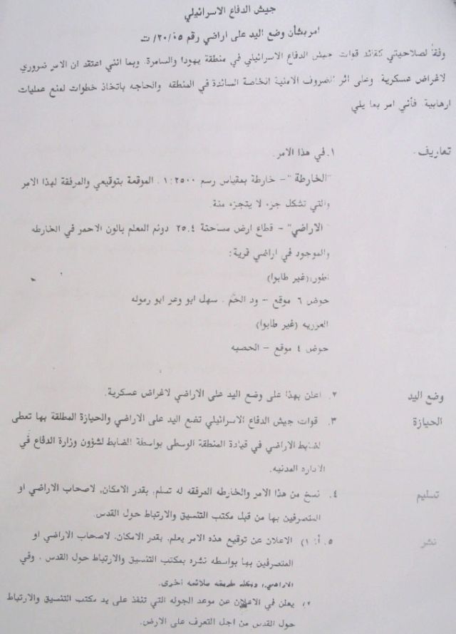
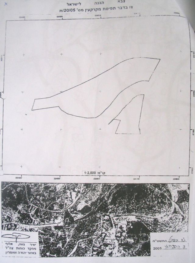
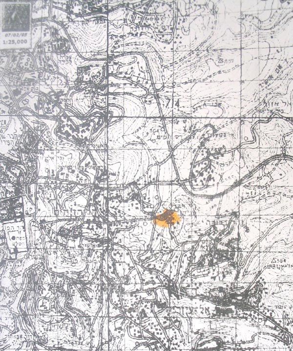
( Photos 1, 2 and 3: Copies of the military decree and attached maps)
On February 16, 2005, Palestinian landowners and representative of Al 'Eizariya Village Council met with Israeli army officers. The Palestinian attendants listened to a briefing given by Israeli officers about the proposed Israeli plan at the site, which aimed at constructing a Wall crossing point between Jerusalem and Al 'Eizariya (Jerusalem southeast). The proposed plan will cause destructive economic and social impacts on the Palestinian residents living in the area because it will lead to a total demolition of a number of houses and properties and will cut through Palestinian areas. As such, there was a strong rejection on the part of Palestinian owners who, on February 23rd, 2005, presented an objection to the Israeli military committee in Beit Eil through their lawyer.
The affected lands and properties are owned by:
1. Bajis Ash Shamali family, basin No. 6, Ras Abu Sbitan, Al Tur quarter;
2. Mr. Mahmoud Mohammed Ali Rabai'ya whose land will be confiscated together with the vicinity of his house at a depth of 15-20 meters which will expose the basis of his house to danger.
3. Mr. Nabil Odeh Abud Qader who will loose part of his land in addition to exposing the basis of his house to danger as a result of excavations at a depth of 15 meters;
4. Az Zir'i family will lose part of their lands. Besides, their residential building will be 3 meters under the level of the newly projected road once excavations and leveling are completed;
5. Raba'iya, Al Fahum, Issa, Misha'al, az Zir'i and 'Inizan families will loose parts of their lands as a result of the above mentioned military order.
Four gateways to Jerusalem
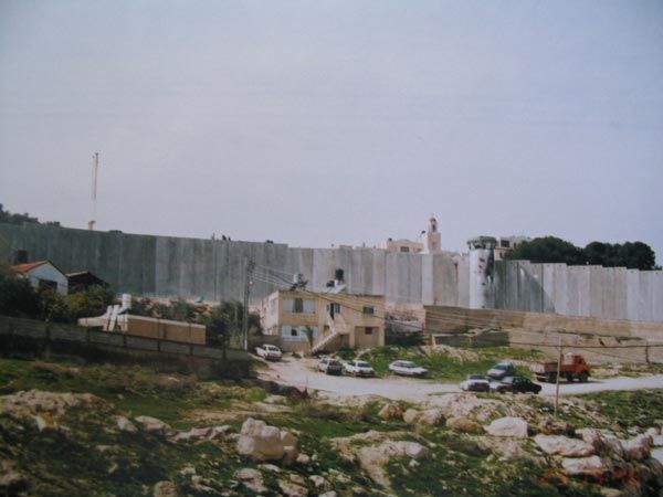
Construction works of the Segregation Wall are underway in Al 'Eizariya town. So far, the route of the Wall has reached the area of Al Bustan and stopped over there. The proposed plan of the crossing point has been set up at Ras Abu Sbitan area between Az Za'ayyem and Al 'Eizariya towns.

Photo 4: Ras Abu Sbitan- Al 'Eizariya:

Photo 5: Ras Abu Sbitan- Al 'Eizariya:
(Photo courtesy of LRC)

(Photo 6: Aerial photo of proposed site of crossing point))
This crossing point will be the only entrance to Jerusalem from the south for Palestinians holding valid permits from the Israeli military. Other crossing points will be constructed as the following:
1. The eastern crossing point will be constructed at the western entrance of Shu'fat refugee camp;
2. The northern crossing point will be constructed at the current Qalandyia checkpoint;
3. The western crossing point will be constructed at Atarut industrial zone.
These crossing points will impose new realities on the ground and further complicate the Palestinian movement in and out of Jerusalem in an attempt to jeopardize its condition and the final status negations with the Palestinians.
(Photo 7: Al 'Eizariya: completed part of the Wall- Photo courtesy of LRC)
Two scenarios
The current route of the Wall in Al 'Eizariya town is threatening to isolate other Palestinain houses, and residential buildings from their owners, which raised the anger of local people and increased tension in the area. Meanwhile, the Israeli occupation authorities are trying to separate the town from the Christian holy sites by annexing them to Jerusalem through the erection of the Wall. The Israeli occupation authorities are talking about two Scenarios to complete the construction of the Wall path in Al 'Eizariya town:
1. The First: a wall to pass by the eastern wall of the Franciscan monastery without annexing its two residential buildings;
2. The second: a wall to encircle the two residential buildings and annex them to Israel. (See attached aerial photo number 9 for the two scenarios).
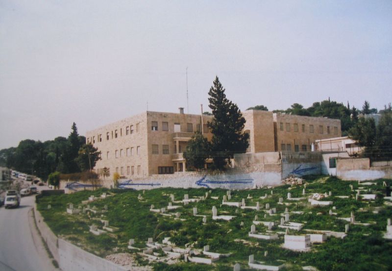
Photo 8: TheFranciscan monastery and the Islamic cemetery of Al 'Eizariya town
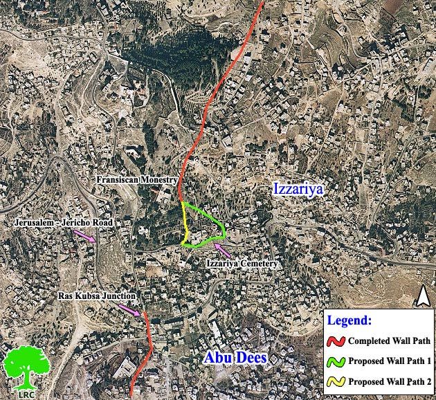
Photo 9: Aerial photo showing stages of Wall construction and the two proposals
(Photo courtesy of LRC)
Splitting the West Bank
Al 'Eizariya Wall and crossing point are part of a 14 km long wall section stretching between the town of Al Za'ayyem in the north and Abu Ghneim settlement (Har Homa) in the south. This section passes through the Palestinian towns of Al 'Eizariya, Abu Dis, As Sawahra ash Sharqiya, Ash Sheik Sa'id, Sur Baher, Um Toba, Khallet An Nu'man and Al Hujeila. The immediate environs of Jerusalem represented by the town of Al Eizariya and the above mentioned communities whose total population reaches 40000 will be separated from Jerusalem city and, consequently, loose their historical, cultural, economic, educational, health and social links with the holy city.
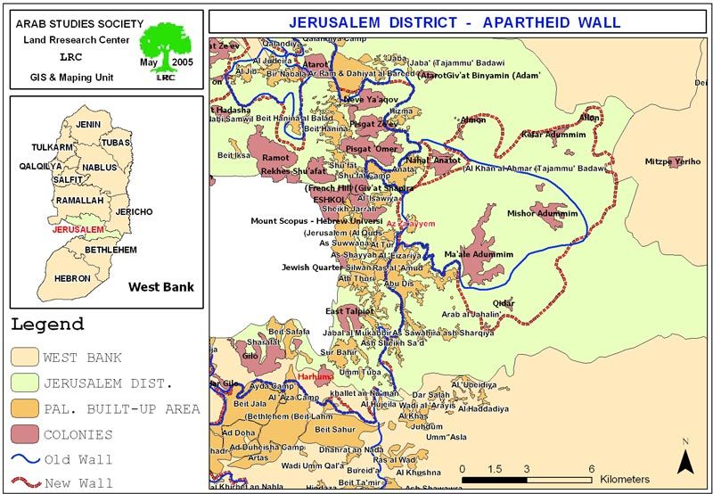
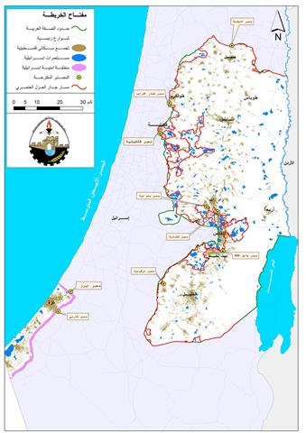
Map 1: Wall plan in Jerusalem district
This section (from Al Za'ayyem to Har Homa settlement) coupled with the new path of Wall according to the revised wall plan of the Israeli government in February 20th, 2005, will split the West Bank into two parts, south and north.
Analysis of February 20, 2005 revised Wall plan:-
The revised Wall plan is much more damaging than the last one published on June 2004, See attached map. The Wall is expected to go deep into the east as the borders of Jericho district form finger like corridors to assure the annexation of the largest settlement in the West Bank Ma'ale Adumim ( 35000 settlers ) in addition to the Qidar, Mishor Adumim, Kfar Adumim, Alon and Almon settlements.
Earlier, the Israeli government announced its E1 plan, which aims at constructing more than 3500 housing units between the Ma'ale Adumim settlement and Jerusalem city to create a geographical contiguity between the city and the eastern Israeli settlements, at the same time, to cut any geographical contiguity between the southern and northern parts of the West Bank.
The Israeli security machineries has finalized the latest preparations for constructing part of the wall which is intended to be started before the scheduled Israeli withdrawal from Gaza so as to appease anti withdrawal Israelis.
Prepared by
The Land Research Center
LRC