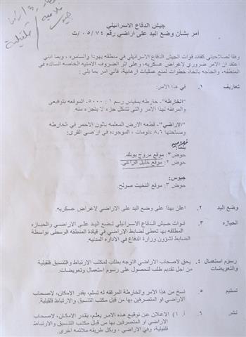
On January 18, 2005, Israeli occupying forces served residents of the Palestinian villages of Beir Nabala, Al Jib and Al Juderia three military orders numbered (05/10/T Judea & Samaria 2005), (05/13/T Judea & Samaria 2005) & (05/11/T Judea & Samaria 2005) stipulating the confiscation of 585.8 dunums (0.59 km2) of agricultural lands cultivated with Olive Trees for constructing the Israeli Segregation Wall. Table 1 below details the area of the three military orders:
Table One: Israeli Military Orders Served to Beir Nabala, Al Jib and Al Juderia (January 18, 2005)
|
location |
Number of order |
Area |
Percent of total village area |
|
|
Dunums |
kilometers2 |
|||
|
Beir Nabala |
05/10/T Judea & Samaria 2005 |
147 |
0.147 |
25% |
|
Al Jib |
05/13/T Judea & Samaria 2005 |
262.2 |
0.262 |
45% |
|
Al Judirea |
05/11/T Judea & Samaria 2005 |
176.6 |
0.176 |
30% |
|
Total |
585.8 |
0.585 km2 |
100% |
|
Palestinians, following the eruption of the second Intifada in September 2000, lost their jobs inside Israel and turned to agriculture as an alternative source of income. Today, like many Palestinian villages in the West bank, these three villages are heavily dependent on agriculture and shepherding which comprise more than 70% of the village's economy. The Segregation Wall, however, is going to isolate theses agricultural lands and place them off limits to the villages' residents and promise to have devastating effects on the humanitarian situation in the village.
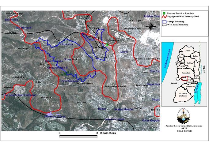
Map one: map of military orders
A Verbatim translation of the military orders along with a detailed maps of the military orders are supplied in Appendix one.
An Updated wall plan by the 'Israeli Ministry of Defense'
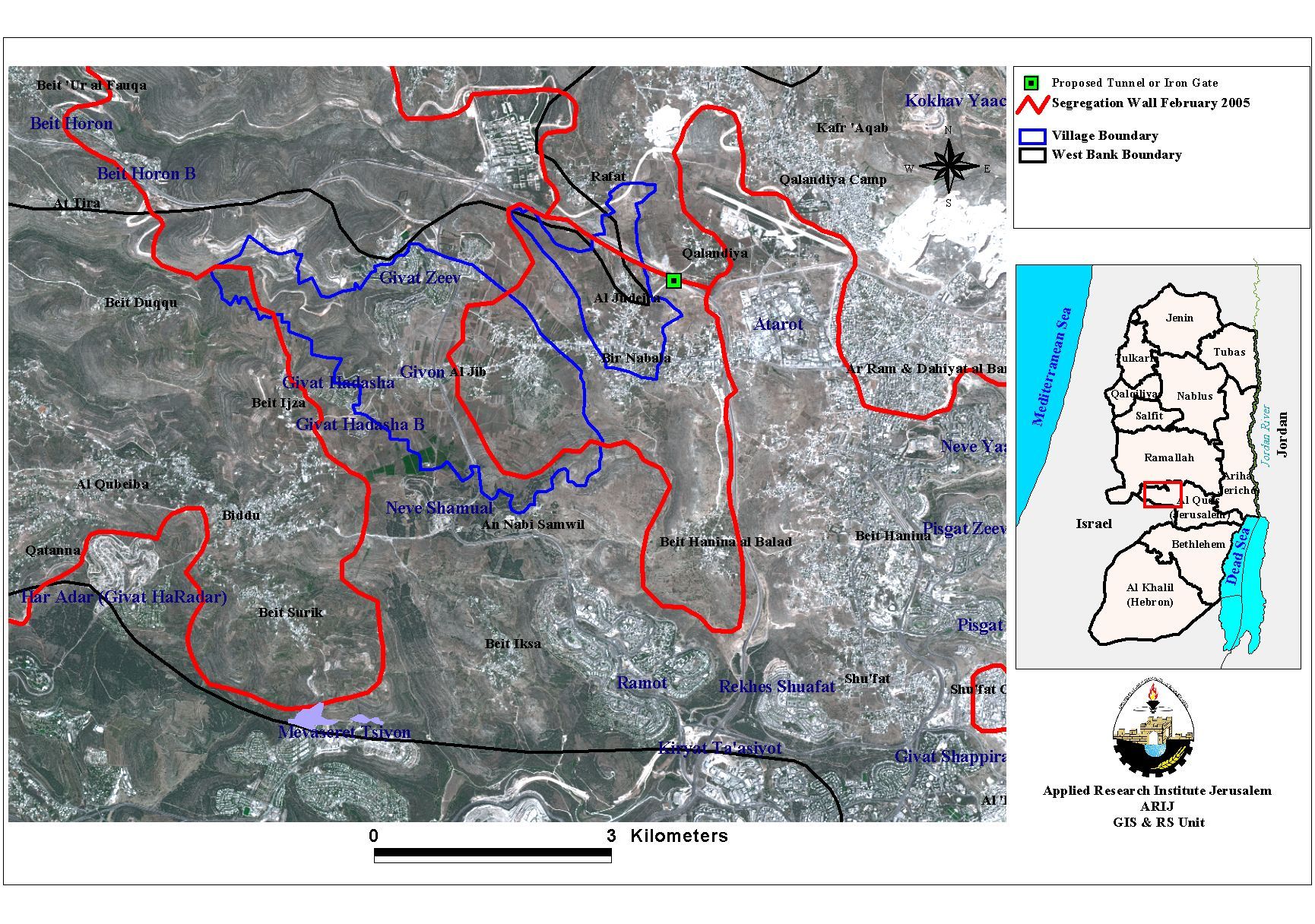
The Segregation Wall is part of Israel's colonization policies in the Occupied Palestinian Territory (OPT). The main goal is to annex as much Palestinian land as possible so that Israel extends its control over additional Palestinian land. The Segregation plan has undergone several modifications, the latest of which was on February 20, 2005 when theIsraeli Ministry of defense issued an 'updated' plan of the Segregation Wall in the West Bank. An in depth analysis conducted by the GIS unit at the Applied research institute – Jerusalem (ARIJ) showed that the updatedwall plan in the villages of Beir Nabala, Al Jib and Al Juderia , differed from that served in the military orders of January 2005 since it physically comes on 5485.75 of dunums of the villages's agricultural lands. See map 2
Map two: Beir Nabala Al Jib and Al Juderia in the Feb. 20th, 2005 plan
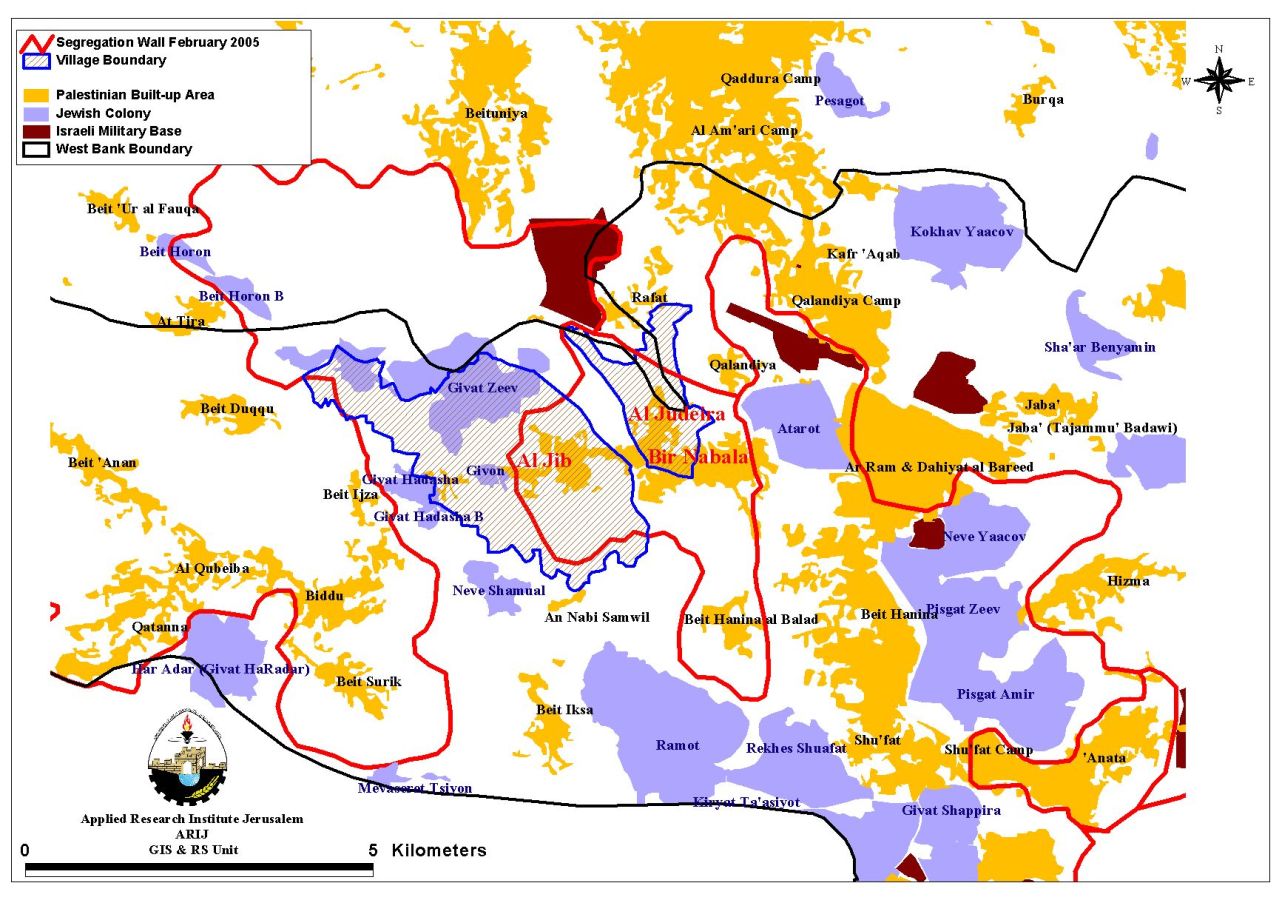
Israeli Settlements surrounding the Three Villages:-
There are three illegal Israeli settlements built on Al Jib traditional territory. The large urban settlements of Giv'at Ze'ev (est. 1977), Giv'at Hadasha (est. 1985) and Giv'on (est. 1978) were built on lands west of Al Jib Village and dominate the open spaces today. The updated Wall path published on theIsraeli Ministry of defense site will annex additional lands from the village at favor of Giv'on settlement and the nearby settlements of Giv'at Ze'ev and Giv'at Hadasha. Table 2 below details the three Israeli settlements and the area they occupy.
Table Two: Israeli settlements established on Lands of Al Jib village
|
Settlement Name |
Date of establishment |
Total area 2003 (in dunums) |
Area of the master plan (in dunums) |
Occupies from village boundary (in dunums) |
Distance from the nearest Palestinian village (in meters) |
||||
|
Area in dunums |
|||||||||
|
Givon |
1978 |
99.17 |
187 |
99.17 from Al Jib village |
12 m from Al Jib village. |
||||
|
Givat Hadasha |
1985 |
307.86 |
573 |
75 from Al Jib village |
1100 m from Al Jib village. |
||||
|
Givat Zeev |
1977 |
2511.28 |
3670 |
1057 from Al Jib village |
750 m from Al Jib village. |
||||
|
|
|
|
|
|
|
||||
|
Total |
|
2918.31 |
4430 |
1231.17 |
1850m |
||||
The settlements of Givat Ze'ev, Giv'on and Giv'at Hahadasha has a combined population of more than 13000 Jewish settlers according to ARIJ GIS Database 2004 and covers an area of 2918 dunums. This area is added to 1132 dunums of land that is going to be annexed to the Israeli settlement of Giv'on once the Wall is constructed in the area.
Table Three: Land use-Land Cover (LULC) in Al Jib village 2005
|
Type land/LULC |
Total areas. |
Area inside the wall (within the enclave). |
LULC annexed to Israel by the Wall (from the village boundary) |
Land left outside the wall (outside the village boundary) and inside the West Bank boundary. |
|
Area in Dunums |
||||
|
Cultivated lands and open spaces |
6318.9 |
2354.03 |
3834.83 |
122.24 |
|
Jewish settlements |
2918.3 |
0 |
1132 |
0 |
|
Palestinian built- up area |
641.31 |
556.26 |
85.05 |
0 |
|
|
|
|
|
|
|
Total |
9878.51 |
2910.29 |
5051.88 |
122.24 |
The three Israeli settlements constitute a settlement block and obstruct any territorial contiguity between the Palestinian villages located northwest of Jerusalem city such as (Beit 'Ur Al Fuqa, Beit Ijza, Beit 'Anan, At Tira, Al Qubeibeh, Bidddu, Qatanna, and Beit Surik) and the villages located on the other eastern side of the settlement block such as (Al Jib, Al Judera, Beir Nabala Rafat, Qalandyia, Ar Ram, Beit Iksa, An Nabi Sameul, Beit Hanina, and Beit Hanina At Tahta).
To the East of Beir Nabala village lies the settlement of 'Atarot or the so known 'Atarot industrial Zone (est. 1970). This industrial zone has consumed much of Ar Ram, and Beit Hanina lands as shown in table below. Today, the settlement is a place for more than 200 stores and factories and is considered as one of the three largest industrial zones in the West Bank along with Mishor Adumim in Jerusalem, and Barqan in Nablus. Besides, the generated industrial solid waste from Atarot is often collected and dumped at the lands of Ar Ram and Beir Nabala, affecting the neighboring lands and people. See Map two
Table Four : Atarot Industrial Zone
|
Settlement Name |
Date of establishment |
Total area 2003 (in dunums) |
Area of the master plan (in dunums) |
Occupies from village boundary (in dunums) |
Distance from the nearest Palestinian village (in meters) |
|
'Atarot |
1970 |
1377.5 |
5352.8 |
39.4 from Ar Ram village , 512 from Beit Hanina. |
|
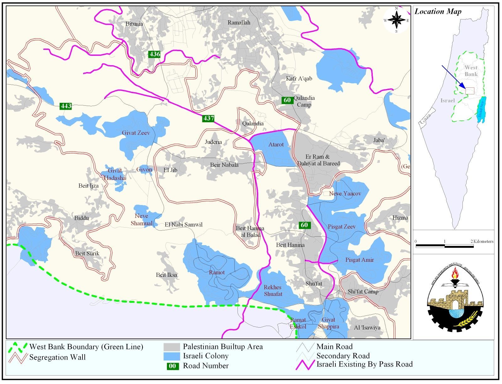
See Map 3: Map of settlements surrounding the three Palestinian villages.
The Segregation wall Route:
The alarming aspect of the path of the Segregation Wall has been the approach through which the Israeli Government succeeded in annexing additional lands to Israel and leaving it open to exploitation by Israeli settlers while causing striking hardships on Palestinians.
According to Beir Nabala Village council, a series of tunnels are proposed to be constructed connecting Beir Nabala, Al Jib and Al Judera enclave to Rafat village – which is situated north of road 45, northern of Al Judera and western of Qalandia-. The entrance of the village of Beir Nabala (Beir Nabal main road) and its neighboring villages, Al Jib, Al Judera and Beit Hanina Al Tahta is also expected to be closed. At least 15000 Palestinians (according to PCBS 2005) will lose access to Ar Ram town and its services; Many difficulties will arise because Palestinian residents will have to travel through alternative routes in the direction of Rafat city, Qalandyia and then to Ar Ram town and the neighboring Palestinian towns. Such routes are longer than the usual tracks residents often take to reach their destinations and costly as well.See Map 3 for more details.
Besides, these Palestinians towns and villages will be sealed from Jerusalem city and their access to the city will be controlled by wall Gates and under ground Tunnels. This in turn would require Palestinians to apply for special permits based on selective classifications put by Israeli Army. (See photo two, three, four and map two)
Villages' Profiles:-
A. Beir Nabala and Al Judera villages are located about 9 kilometers northwest of Jerusalem city. Both villages constitute a total population of 8446 (Beir Nabala 6264, Al Judera 2182) inhabitants according to the Palestinian Central Bureau of Statistics (PCBC) 2005 and constitute a built-up area of 1904.35 dunums spreading on the neighboring villages of Al Jib, Beit Hanina Al Tahata and Betunia city. 551.43 dunums (0.5 km2) of the total are located with the Villages' built-up area. Both villages' Residents depend generally on agriculture as their source of living where most of the lands are cultivated with Old Roman Olive trees.
Table Five: Land Use-Land Cover (LULC) in Beir Nabala & Al Judera villages (2005)
|
Type land/LULC |
Total area |
Area inside the enclave |
Land left outside the wall (outside the village boundary) and inside the West Bank boundary. |
|
Area in Dunums |
|||
|
Cultivated lands and open spaces |
1512.7 |
1121.99 |
390.28 |
| Palestinian built up area (spread on lands of the four villages of Betunia, Beit Hanina, Al Judera and Al Jib). | 1904.35 (551.43 out of total is inside the village boundary) | 544.40 | |
|
Total |
3416.05 |
1666.39 |
396.68 |
B. Al Jib village:
The Palestinian village of al-Jib is located 12 km northwest of Jerusalem city. The village can be reached through the main Jerusalem-Ramallah Road, from al Ram junction, where a road leads westward to the Beir Nabala village and then to al-Jib. The built-up area comprises an area of 641.31 dunums.
The village of Al Jib houses a total population of 4775 inhabitants according to the (PCBS 2005) where five major clans constitute its population: Abo Hamoud, Abo Dia', Al Shahbna, Assaf, Hatab and Al Halayka. Its Inhabitants turned to depend on agriculture (mostly Olive and Wheat) following the eruption of the second Intifada in September 2000 and after losing their Jobs inside Israel.
The Wall and International law:-
The Israeli Segregation Wall has harsh impacts on the Palestinian society, especially that it cuts off the agricultural lands from its original owners, and deprives them their living; thus affecting the economic situation.
The wall also restricts the movement of Palestinians and extends to affect the educational and medical systems as well. Palestinians living in the three villages will lose their contacts with the nearby villages and centers due to restrictions already imposed on them by checkpoints and will significantly increase by the completion of the Segregation Wall.
The construction of the Segregation Wall is a blatant violation of International law and UN resolutions:
Fourth Geneva Conventions, Article 53: Any destruction by the Occupying Power of real or personal property belonging individually or collectively to private persons, or to the State, or to other public authorities, or to social or cooperative organizations, is prohibited, except where such destruction is rendered absolutely necessary by military operations.
Fourth Geneva Conventions, Article 33:
-
No protected person may be punished for an offence he or she has not personally committed. Collective penalties and likewise all measures of intimidation or of terrorism are prohibited.
-
Pillage is prohibited.
-
Reprisals against protected persons and their property are prohibited.
The Wall also violates the International Covenant on Civil and Political Rights and the International Covenant on Economical, Social, and Cultural Rights both of which Israel has signed.
The International Covenant on Civil and Political Rights (ICCPR) – Freedom of movement (ICCPR, art. 12):
1. Everyone lawfully within the territory of a State shall, within that territory, have the right to liberty of movement and freedom to choose his residence.
2. Everyone shall be free to leave any country, including his own.
3. The above-mentioned rights shall not be subject to any restrictions except those which are provided by law, are necessary to protect national security, public order (order public), public health or morals or the rights and freedoms of others, and are consistent with the other rights recognized in the present Covenant.
4. No one shall be arbitrarily deprived of the right to enter his own country.
The International Covenant on Civil and Political Rights (ICCPR) – Property (ICCPR, article 1): All peoples have the right of self-determination. By virtue of that right they freely determine their political status and freely pursue their economic, social and cultural development.
The International Covenant on Economic, Social and Cultural Rights (ICESCR) – health (ICESCR, article 12): The States Parties to the present Covenant recognize the right of everyone to the enjoyment of the highest attainable standard of physical and mental health.
Fourth Geneva Conventions, article. 32: A protected persons shall not be have done to them anything of such a character as to cause the physical suffering or extermination … the physical suffering or extermination of protected persons in their hands. This prohibition applies not only to murder, torture, corporal punishments, mutilation and medical or scientific experiments not necessitated by the medical treatment
The International Covenant on Economic, Social and Cultural Rights (ICESCR) – Education (ICESCR, art.13: The States Parties to the present Covenant recognize the right of everyone to education. They agree that education shall be directed to the full development of the human personality and the sense of its dignity, and shall strengthen the respect for human rights and fundamental freedoms.
The International Covenant on Economic, Social and Cultural Rights (ICESCR) – Work (ICESCR, art. 6): The States Parties to the present Covenant recognize the right of everyone to the enjoyment of just and favorable conditions of work which ensure, in particular
The International Covenant on Economic, Social and Cultural Rights (ICESCR) – Food (ICESCR, art. 11): The States Parties to the present Covenant recognize the right of everyone to an adequate standard of living for himself and his family, including adequate food, clothing and housing, and to the continuous improvement of living conditions. The States Parties will take appropriate steps to ensure the realization of this right, recognizing to this effect the essential importance of international co-operation based on free consent.
Appendix one: Military orders served to residents of Beir Nabala, Al Jib and Al Judirea villages on January 18, 2005
Military order no. (05/10/T Judea & Samaria 2005):
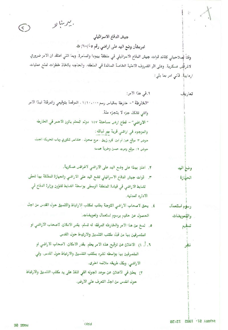

|
Israel Defense Forces Order to Seize lands n0 05/10/T According to my authorities as a Military Chief Commander in the Region of Judea and Samaria, and as I believe that it is imperative for military reasons due to the special security situation in the region, I order the following: 1. The 'Map' signed in scale 1: 100000 and attached to the order is an essential part of this order. The 'Lands' : An area of land which is 147 dunums marked in red in the map :
2. I announce by that the above mentioned lands are seized for military reasons 3. The IDF seize the lands and have an absolute control over it that is given to the officer of the central command officer of lands who is responsible in the ministry of defense. 4. These copies are to be given by the District Co-ordination Office 'The DCO' of Ramallah to the owners of land. 5. Copies are found with maps for those who are interested in the following places :
6. The owners of land have the right to go to the DCO in Ramallah in order to get more information about their right of land use expenses and compensation. 7. The Validity of this order starts at the date signed till 31/12/2007 8. The name of this order is: ' Order to seize lands n0 05/10/T (Judea & Samaria ) 2005
Mosheh Kaplenski |
Military order no. (05/13/T Judea & Samaria 2005):

|
Israel Defense Forces Order to Seize lands n0 05/13/T According to my authorities as a Military Chief Commander in the Region of Judea and Samaria, and as I believe that it is imperative for military reasons due to the special security situation in the region, I order the following: 2. The 'Map' signed in scale 1: 100000 and attached to the order is an essential part of this order. The 'Lands' : An area of land which is 262.2 dunums marked in red in the map :
6. I announce by that the above mentioned lands are seized for military reasons 7. The IDF seize the lands and have an absolute control over it that is given to the officer of the central command officer of lands who is responsible in the ministry of defense. 8. These copies are to be given by the District Co-ordination Office 'The DCO' of Ramallah to the owners of land. 9. Copies are found with maps for those who are interested in the following places :
9. The owners of land have the right to go to the DCO in Ramallah in order to get more information about their right of land use expenses and compensation. 10. The Validity of this order starts at the date signed till 31/12/2007 11. The name of this order is: ' Order to seize lands n0 05/13/T (Judea & Samaria ) 2005
Mosheh Kaplenski |
Military order no. (05/11/T Judea & Samaria 2005)
|
Israel Defense Forces Order to Seize lands n0 05/11/T According to my authorities as a Military Chief Commander in the Region of Judea and Samaria, and as I believe that it is imperative for military reasons due to the special security situation in the region, I order the following: 3. The 'Map' signed in scale 1: 100000 and attached to the order is an essential part of this order. The 'Lands' : An area of land which is 176.6 dunums marked in red in the map :
10. I announce by that the above mentioned lands are seized for military reasons 11. The IDF seize the lands and have an absolute control over it that is given to the officer of the central command officer of lands who is responsible in the ministry of defense. 12. These copies are to be given by the District Co-ordination Office 'The DCO' of Ramallah to the owners of land. 13. Copies are found with maps for those who are interested in the following places :
12. The owners of land have the right to go to the DCO in Ramallah in order to get more information about their right of land use expenses and compensation. 13. The Validity of this order starts at the date signed till 31/12/2007 The name of this order is: ' Order to seize lands n0 05/11/T (Judea & Samaria ) 2005
Mosheh Kaplenski |
Prepared by:
The Applied Research Institute – Jerusalem