Location of Biddu village:-
Biddu village lies 9 km. northwestof Jerusalem city. Its topographic relief is mountainous and reaches up to 850 meters above the sea level. It is situated on a Land area totaling 5680 dunums (5.68 km2) in which Olive trees are cultivated. The built- up area represents only 8.8% of the village's total area; a total of 500 dunums (0.5 km2). It is surrounded by Al Nabi Sameul and Al Jib villages from the east, Beit Ijza and Al Qubeibeh from the north, Qatannah from the west and Beit Surik from the south.
Biddu village Population
In Year 1922, Biddu village's population was 252 inhabitants, increased to 520 inhabitants in 1945 and 1259 inhabitants in 1967. In 1987, Biddu population totaled 2846 inhabitants and in 2004, 6550 inhabitants according to PCBS statistics 2004.
|
Year |
Population |
|
1922 |
252 |
|
1945 |
520 |
|
1967 |
1259 |
|
1987 |
2846 |
|
1996 |
3358 |
|
2004 |
6550 |
Four major clans form the population of the village; Mansor, Abu Aied, Badwan and Saada. More than 70% of Biddu's population depends on agriculture where Olive constitutes the major source of income for Village residents.
Glance about Biddu:-
The village of Biddu was subject to Israeli targeting since 1948 when the Israeli militias completely destroyed the village and depopulated its residents from their lands. Later on, the village residents' rebuilt, restored and developed the village to what it stands today.
Today, the village of Biddu is hemmed in by two illegal Israeli settlements. The settlement of Givat Hadasha (built in 1980) to the northeast of the village and sits on 215 dunums (0.2 km2) of Biddu village lands; and the settlement of HarAdar (built in 1985) which sits on 920 dunums (0.9 km2) of Biddu village lands and is located to the west of the village.
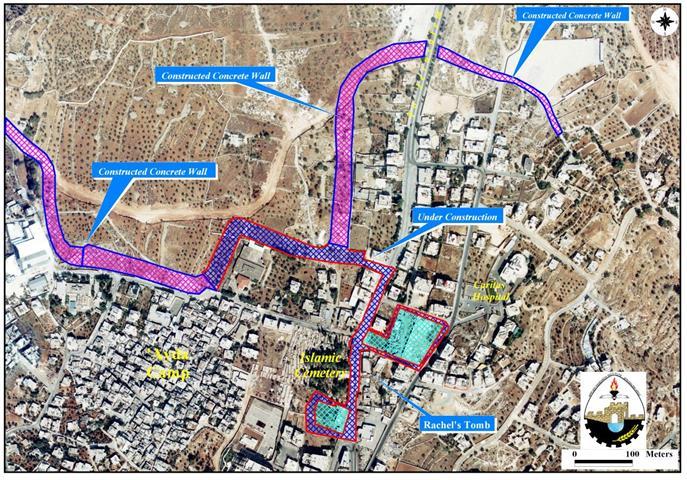
The Israeli Segregation Wall in Biddu Village:
Biddu, as many other Palestinian villages which are in similar or worse positions, is now facing the threat of the Israeli segregation plan. In early February 2004, the Israeli bulldozers started bulldozing lands of Biddu village, setting the path of the Segregation Wall in the area.
The Israeli bulldozers and army were met by non-violent demonstrations organized by Village resident to stop the wall constructions in their village. Residents of Biddu also filed suits to the Israeli Supreme Court to stop the Israeli Army and Bulldozers from continuing their work. The residents were able to obtain a court order to halt all work to the time when the court reaches a decision. The Israeli army then resumed bulldozing the land few days later after the court's ruling to halt the work.
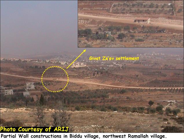
As one enters Biddu village, a partially completed section of the Segregation Wall can be easily seen. This section already confiscated a considerable area of Biddu village lands and constituted to the major destruction caused to the village. See Photo 1 & 2 below
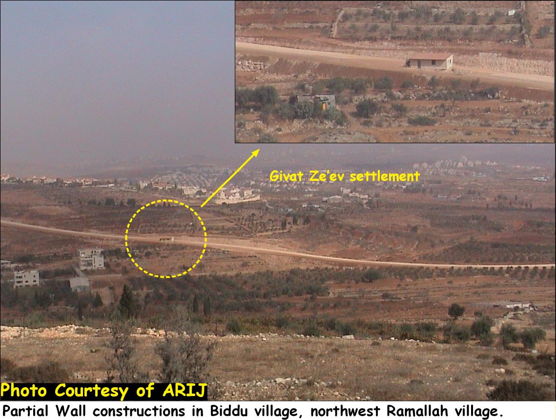

Photo 1 & 2: A partial completed wall as seen from Biddu village.
In June 29, 2004, the Israeli High Court ordered a halt to the construction of the 30 Kilometer section of the Segregation Wall (according to June 2004 Wall Map provided by the Israeli Authorities) affecting nine Palestinian villages located north and northwest Jerusalem city; of which, Biddu was included.
The Israeli Occupation forces later in November distributed three new military orders (Military order n0 04/75/T, Military order n0 04/76/T and Military Order n0 04/87/T) to Palestinians living in the nine above mentioned villages stating a new route of the Segregation wall to be implemented and differs from that published at to Palestinians living in the nine above mentioned villages stating a new route of the Segregation wall to be implemented and differs from that published at the ministry of defense webpage on June 30, 2004. See map 1
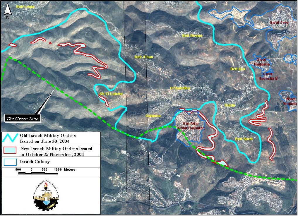
Map 1: Old and new route of the Wall in villages located northwest Ramallah city
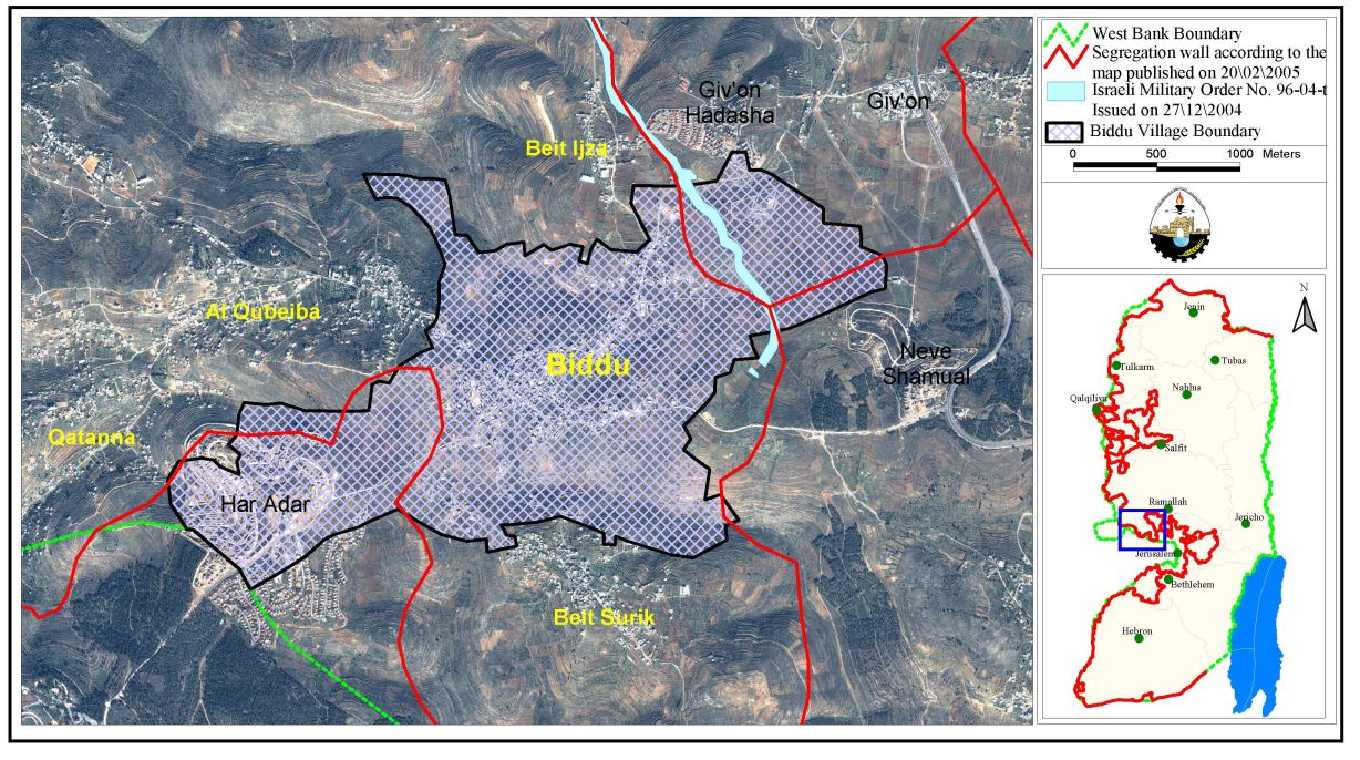
Military order number 04/75/T specifies that the Wall will cut within 180 meters of Palestinian homes (1000 meters away from the Green Line) in Biddu village. Some sections of the wall will be set exactly on the Armistice Line whereas other sections reach as far as 1000 meters into the occupied West Bank. As a result, the Wall will have the effect of dramatically redrawing the border between Israel and the West Bank in order to annex the illegal Israeli settlement of Har Adar as shown in Map 2 Below.
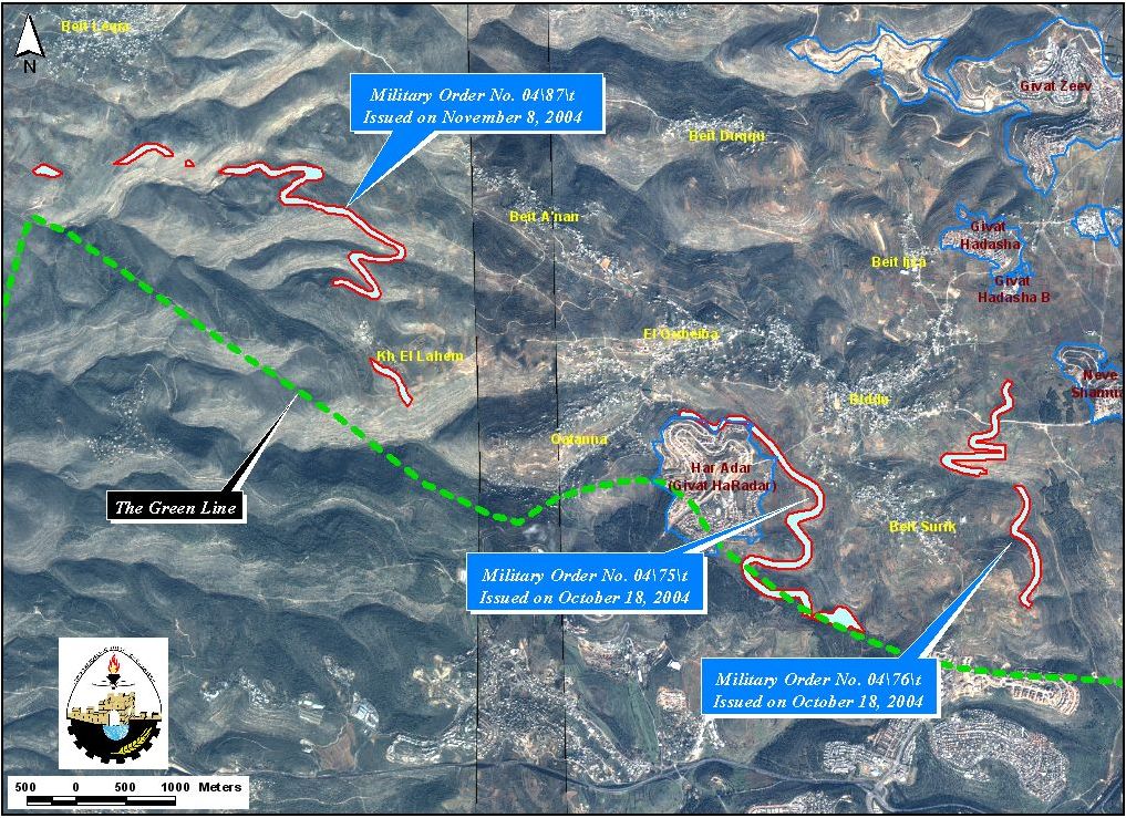
Despite changes made in the route, the new orders do not move the Wall to the Armistice line (Green Line – the 1948 internationally recognized border).
On December 27, 2004, the Israeli occupation forces served Biddu villagers new military order numbered (04/96/T Judea & Samaria 2004) stating the confiscation of 71.9 dunums of their agricultural land for resuming wall constructions in the area. By analyzing the military order, an approximate of 1800 dunums (2 km�²) of Biddu village lands (34% of the village's total area) will be confiscated. The wall will also stretch to a total length of 3 kilometers encircling the settlement of Har Adar, at the same time, confiscating much of Biddu's lands. Read the translation of Military order:
|
Israel Defense Forces Order to Seize lands n0 04/96/T
According to my authorities as a Military Chief Commander in the Region of Judea and Samaria, and as I believe that it is imperative for military reasons due to the special security situation in the region, I order the following:
1-The 'Map' signed in scale 1: 5000 and attached to the order is an essential part of this order. The 'Lands' : An area of land which is 71.9 dunums, marked in red in the map :
2- I announce by that the above mentioned lands are seized for military reasons 3- The IDF seize the lands and have an absolute control over it that is given to the officer of the central command officer of lands who is responsible in the ministry of defense. 4- These copies are to be given by the District Co-ordination Office 'The DCO of Ramallah to the owners of land.
5- Copies are found with maps for those who are interested in the following places :
6- The owners of land have the right to go to the DCO in Ramallah in order to get more information about their right of land use expenses and compensation. 7- The Validity of this order starts at the date signed till 31/12/2007 8- The name of this order is: Order to seize lands n0 04/96/T (Judea & Samaria) 2004.
Mosheh Kaplenski |
In February 20, 2005, the Israeli Ministry of defense issued an updated plan of the Segregation Wall in the West Bank. According to this plan the Wall will physically come on 4.5 kilometers (length) and confiscate 300 dunums (0.3 km2) of Biddu village lands, isolating approximately 2000 dunums (2 km 2) of their agricultural lands. (See map 3 and tables 1 & 2 below)
|
Table 1; lands isolated inside the main Wall (West of the Wall), 2005. |
||
|
Type land |
Area/Dunums |
Percent of total |
|
|
|
|
|
Arable land |
709 |
34% |
|
Jewish settlements |
0.769 |
38% |
|
Palestinian built-up area |
21 |
10% |
|
Open Spaces |
0.357 |
17% |
|
|
|
|
|
Total |
2045 |
100% |
|
Table 2; lands isolated outside the main Wall (East of the Wall), 2005. |
||
|
Type land |
Area/Dunums |
Present of total |
|
|
|
|
|
Arable land |
1.362 |
39% |
|
Jewish settlements |
0.022 |
1% |
|
Palestinian built-up area |
0.893 |
27% |
|
Open Spaces |
1.152 |
33% |
|
|
|
|
|
Total |
3429 |
100% |
Conclusion:-
Despite Israel's statements that the Segregation Wall is meant for defensive purposes, the Wall does not follow the route of the Armistice Line. Instead, it cuts deep into the occupied Palestinian territories, isolating thousands of Palestinians from the remains of the Occupied Palestinian Territories, and creating small ethnic ghettos completely surrounded by walls and fences.
The annexation of land by force is a clear violation of the Fourth Geneva convention and international laws. Hague Regulations 1907 and the fourth Geneva
Conventions
Hague Regulations 1907 Section III Article 46 states that'
-
Section II Article 23: [it is especially forbidden] to destroy or seize the enemy's property, unless such destruction or seizure be imperatively demanded by the necessities of war.
-
Section III Article 46: 'Family honour and rights, the lives of persons, and private property, as well as religious convictions and practice must be respected. Private property cannot be confiscated.'
Fourth Geneva Conventions
-
Article 53: 'Any destruction by the Occupying Power of real or personal property belonging individually or collectively to private persons, or to the State, or to other public authorities, or to social or cooperative organizations, is prohibited, except where such destruction is deemed absolutely necessary by military operations.'
Prepared by:
The Applied Research Institute – Jerusalem