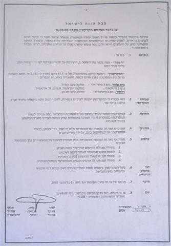
Head of the Israeli Forces Central Command, Gen. Yair Neve issued a new land confiscation order on March 24, 2005 stipulating the confiscation of 224 dunums of Palestinian owned land in the villages of Kafr Thulth and Azzun in Qalqiliya Governorate. According to the military order which carries number T/65/05 (a copy of which is attached to this report), a strip of land at a length of 2140 meters and an average width of 105 meters will be confiscated for ' military necessities and prevailing the security situations in the area and the need to take measures to stop terrorist attacks '. The actual purpose for the land confiscation is for the construction of a new section of the Segregation Wall in the eastern part of Qalqiliya governorate. See copy of military order

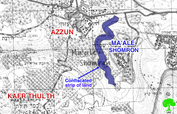
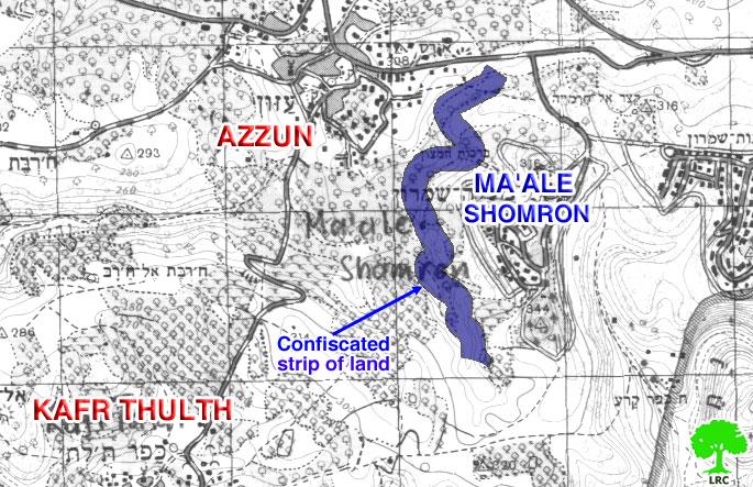
( photo 1 & map 1: A copy of the military order and attached map)
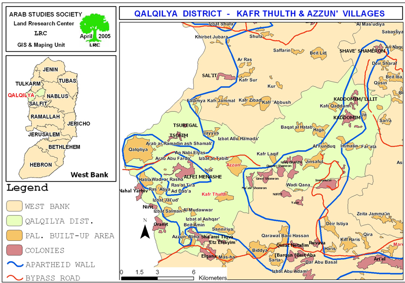
This military order is the second of its type since the beginning of the current year in Qalqiliya Governorate. The first one was issued on February 2nd, 2005, and stated the confiscation of about 300 dunums of Deir Istiy and Imatin villages' lands for the same purpose. The aforementioned confiscations aim at completing the second phase of the Segregation Wall in the Governorate which will circumvent and annex the settlements of Karne Shomron, Kedumim, Emmanuel, Ma'ale Shomron and Ariel in the south into Israel's proper. It is also expected that upon the completion of this phase, more than 40,000 dunums of Qalqiliya governorate's lands will be segregated behind the Wall.
Location and population
The town of Kafr Thulth is located 12 kilometers south east of Qalqiliya city and is 6 kilometers away from the 1949 Armistice Line (Green Line). Its lands extend from the town of Azzoun in the north to reach the town of Sanniriya in the south, the Green Line in the west and reach the town of Deir Istiya in the east. The village's population according to the Palestinian Central Bureau of Statistics (PCBS) 2004 is about 5,000. (Green Line). Its lands extend from the town of Azzoun in the north to reach the town of Sanniriya in the south, the Green Line in the west and reach the town of Deir Istiya in the east. The village's population according to the Palestinian Central Bureau of Statistics (PCBS) 2004 is about 5,000.
Kafr Thuluth town is considered the 'mother' village of the following 'sub-villages': Izbat Salman, Izbat Jal'ud, Izbat Al Madwar, Ras at Tira, Ras Atiya, Al Daba' and Wadi ar Rasha. As such, the town of Kafr Thuluth and its subs are considered one unit in terms of population and agricultural lands.
The 1948 War led to the confiscation of 20% of the towns' lands which amounts to about 4,000 dunums. Two Israeli settlements were established on the occupied lands; Kharshim settlement, established on ruins of Khraish town, a Palestinian village destroyed during the 1948 war and Nirid settlement established on a location called Ahrash Al Zaqoor. The remaining 80% of the town's land remained within the borders of the West Bank.
The town of Azzun is located to the north east of Kafr Thulth and is about 8 km to the east of Qalqiliya city. Its population is about 5200 inhabitants according to the PCBS 2004 statistics. Both Kafr Thulth and Azzun towns will be isolated in one enclave once the erection of the Wall is completed; Furthermore, the two villages will be left with only one bottle neck passage in the north of the enclave.
Previous violations
The recent violations that Kafr Thulth and the surrounding villages are facing are a continuation of the series of violations faced through out the years of Israeli occupation as the villages come under successive attacks, the latest of which was in December 2004 when a group of Israeli settlers forcibly seized pieces of lands south of Ma'ale Shomron settlement in an attempt to construct a 4 km long and 4 meters wide road leading to the new colonial hilltop post established two years ago.
( map 2: location of Kafr Thuluth and Azzun)
Currently, this colonial outpost is provided with water and electricity services and contains about 12 caravans (mobile homes); moreover, the settlers shaved down more than 9000 fruitful olive trees in the vicinity of the above-mentioned colonial outpost. The trees belong to Mr. Farid Muqbil, Mr. Othman Muqbil, Mr. Musa Muqbil, Mr. Hamid Zeeb Odeh and Mr. Abdul Halim Shaker and brothers. Furthermore, Palestinian shepherds and cattle breeders are frequently attacked and terrorized by Ma'ale Shomron's settlers under security pretexts.
The Israeli Segregation Wall and Palestinian villages:
The construction of the Wall will lead to the confiscation and segregation of about 8000 dunums of Kafr Thuluth and the sub-villages associated with it apart from the town of Azzun. This figure constitutes 45% of Kafr Thuluth total area. It will also lead to the total isolation of the sub-villages such as Ras at Tira, Al Dab'a and Wadi ar Rasha as the Wall is supposed to encircle them from all directions. Such a grip will transform the Palestinian residents of these villages from being farmers and/or workers inside Israel into unemployed people. Furthermore, the construction of the Wall has deprived residents of Kafr Thulth and Azzun towns any prospect of future expansion to meet the demands of natural population growth.
Conclusion
In July 2003, the international court of Justice (ICJ) passed an advisory opinion 'By fourteen votes to one' declaring that Israel's Wall is illegal. 'The construction of the wall being built by Israel, the occupying Power, in the Occupied Palestinian Territory, including in and around East Jerusalem, and its associated r�©gime, are contrary to international law';'
The court's decision came with reference to existing international law, including the Fourth Geneva convention, The Hague Regulations, various Human Rights laws and UN security council resolutions.
The requirements of Resolution 242 are re-enforced and strengthened by UN Security Council Resolutions 452 (1979) and 465 (1980). Resolution 465 states categorically that: 'all measures taken by Israel to change the physical character, demographic composition, institutional structure of status of the Palestinian and other Arab territories occupied since 1967, including Jerusalem, or any part thereof, have no legal validity and that Israel's policy and practices of setting parts of its population and new Immigrants in those territories constitute a flagrant violation of the Fourth Geneva Convention Relative to the Protection of Civilian Persons in Time of War and also constitute a serious obstruction to achieving a comprehensive, just and lasting peace in the Middle East. '
Hague Regulations of 1907 and the Fourth Geneva Convention of 1949:
-
The Hague Regulations expressly forbids an occupying power 'to destroy or seize the enemy's property, unless such destruction or seizure be imperatively demanded by the necessities of war' (Article 23).
-
The Fourth Geneva Convention, the primary document of international law governing instances of military occupation, states in Article 49 that: 'The occupying power shall not deport or transfer parts of its own population into the territories it occupies.'
-
Article 53 of the Fourth Geneva Convention is also clear that: 'any destruction by the Occupying Power of real or personal property belonging individually or collectively to private persons, or to the State, or to other public authorities, or to social or cooperative organizations, is prohibited, except where such destruction is rendered absolutely necessary by military operations.'
-
The appropriation and destruction of Palestinian land is an especially serious violation of the Fourth Geneva Convention, Article 147 of which clearly prohibits, ''extensive destruction and appropriation of property, not justified by military necessity and carried out unlawfully and wantonly.'' Violations of Article 147 constitute grave breaches of the Convention and should be prosecuted as War Crimes.

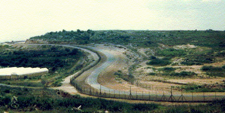
( Photo 3: the snaky path of the Wall passing the lands of Kafr Thulth – Photo courtesy of LRC)
Prepared by
The Land Research Center
LRC