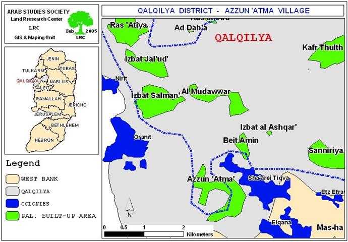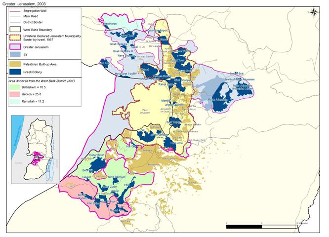
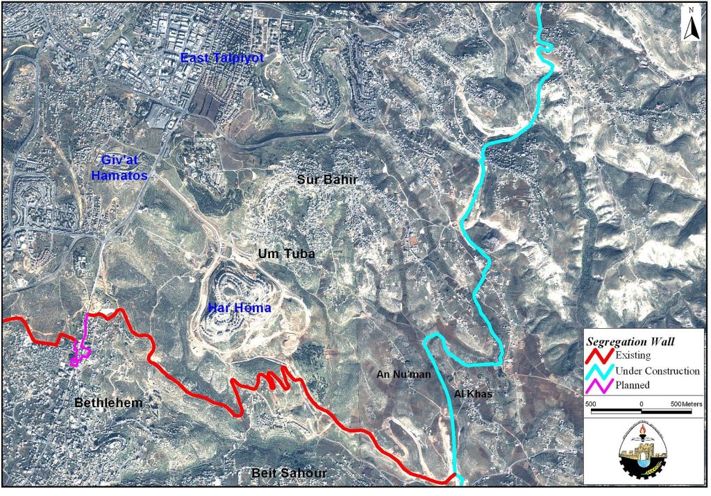
When Israel commenced the building of the Segregation Wall in 2002 along the western parts of the West Bank, it also included occupied East Jerusalem, even though it has done so under a different naming and called it the 'Jerusalem Envelope'. Sur Baher town is one of many unfortunate towns that crossed path with the Segregation Wall and suffers as a result the anguish of tearing the fabric of their society as parts of the towns built up areas were slated out in addition to 151 Dunums of the cultivated lands. The harassment of Sur Baher residents by Israel continue to endure as calls of threats to demolish houses located where the route of the Segregation Wall penetrates are announced from time to time. See Map below

Recently, (January 31, 2005), the Israeli Border Police revealed its intention to demolish an entire Palestinian neighborhood in Sur Baher town located southeast of Jerusalem in order to 'protect the separation fence built in the area'. The announcement made by the Israeli Border Police commander Amitai Levy in-charge of Jerusalem envelope area divulged the latter decision to create a 500-meter wide security buffer zone along each side of the fence penetrating the Palestinian lands around Jerusalem. According to Levy's decision, dozens of Palestinian houses in Al-Mintar neighborhood in Sur Baher town face the caterpillar of demolition.
In an inspection of the impact of the Israeli Border Police commander decision on the residents of Sur Baher, some 74 houses falls within the 500 meter wide range proclaimed by Levy to protect the fence. However, the buffer zone area set along the segregation fence and wall through out its route in parts of the West Bank averages 60 to 100 meter; even though at some points, the segregation wall literally come into contact with Palestinian houses or sets few meters from them. The Border Police commander said that the targeted houses for demolition are built without permit from Jerusalem municipality, which constitutes an additional reason to demolish them. Following a protest by the residents of the town, the Israeli Municipality discarded the Israeli Border Police commander decision stating that it is not within the Israeli border police jurisdiction to determine the policy for house demolishing within the Municipality's boundaries. Furthermore the Israeli Municipality announced its intention to reset the town's master plan to include the town's southeast area where most of the threatened houses are located. However, the council and the residents believe that the talks regarding a new master plan will not corollary of more than words as it has been for so many years. See Map below .
The houses at the targeted neighborhood were built without permits only because the Israeli municipality of Jerusalem in many cases refuses to grant the Palestinian inhabitants of the city permits to build or develop their townships in an attempt to push the Palestinian residents out of the city. Residents of Sur Baher started building Al-Mintar neighborhood in the early nineties, as they were denied by the Israeli Municipality of Jerusalem to expand the town's built area for so many years to accommodate the natural increase in the number of inhabitants. Furthermore, the decision of the Israeli Municipality of Jerusalem and the Israeli government to build an Israeli settlement south of Sur Baher and on parts of lands that belong to the residents escalated the tension especially that the Israeli municipality had constantly denied Sur Baher residents the right to use the same lands were Har Homa was built under pretext of: natural reserved area. Following the 1967 Israeli occupation of East Jerusalem, Israel capitalized most of Sur Baher village lands reserved for town's development for future generations, and built on them two Israeli settlements (East Talpiot 1973, Har Homa 1997).
Sur Baher after 1967
When Israel occupied the West Bank and Gaza territories in 1967, it unilaterally and illegally redrew the boundaries of occupied East Jerusalem, which excluded more than 2000 Dunums of Sur Baher lands on the southeast side of the town. Since the new Israeli boundaries were only visible on Israeli maps, it did not constitute any immediate threat to the lives of Sur Baher residents, at least not until the blueprint became a reality when Israel commenced its Jerusalem Envelope plan and the Segregation Wall to exclude the city from the rest of the occupied Palestinian territories.
Furthermore, the consecutive Israeli governments confiscated more than 2000 Dunums of Sur Baher lands to build East Talpiot settlement in 1970 and nearly 900 Dunums in 1997 for Har Homa settlement; thus eliminating the towns' reserved territories for future expansion. Consequently, the residents of Sur Baher had no choice but to expand toward the southeast direction of the town; the same area designated by Israel to rig the Segregation Wall that which will isolate 85 Palestinian houses and families from their way of life in Sur Baher. However, the residents of the targeted area appealed the route of the Segregation Wall and demanded to reroute it further east so as not to exclude any of the town's houses. The command of the Israeli Army responded to the town's protest and rerouted the Segregation Wall, even though the adjusted route continues to exclude few houses.
Facts & Realities
Following 1967, Israel commenced a development plan of Jewish neighborhoods in occupied East Jerusalem in contrary to article 49 of the fourth Geneva Convention of 1949 that prohibit transferring parts of the occupying power population into the occupied territories.
The Fourth Geneva Convention, (August 12, 1949): Art. 49. Individual or mass forcible transfers, as well as deportations of protected persons from occupied territory to the territory of the Occupying Power or to that of any other country, occupied or not, are prohibited, regardless of their motive.
Even though Israel announced schemes over its years of on-going occupation of East Jerusalem for Palestinian construction, it had never come through as the plans were dismissed later on. An explicit example would be the Israeli government's pledge to give 18000 permits to the Palestinians in 1980 (reduced to 7500), as the earlier were announcing plans to build Pisgat Ze'ev settlement on Palestinian expropriated lands. Even though 25 years have passed, the only construction plans that were carried out are those of Pisgat Ze'ev settlement while the Palestinians still awaits their building permits to come through.
Construction of Jewish housing units on lands expropriated from Palestinians in East Jerusalem flourished rapidly over the years of occupation as statistics from 'Americans for Peace Now' shows that by the year 1997; 40,000 Jewish residential units have been built and by the end of 2001 the number escalated to nearly 47,000 (Bt Selem); both sources affirmed that not a single unit have been built by the government for the Palestinians who constitute 32% of Jerusalem population.
The following references clearly cite the Israeli violation of the international human rights to which Israel is a part:
The Universal Declaration of Human Rights, (Article 25.1): 'Everyone has the right to a standard of living adequate for the health and well-being of himself and his family, including food, clothing, and housing.
The International Covenant on Economic, Social, and Cultural Rights, (Article 11.1): 'The right of everyone to an adequate standard of living … including adequate food, clothing, and housing…'
The International Convention on the Elimination of All Forms of Racial Discrimination, (Article 5): Obligates State Parties 'to … guarantee the right of everyone, without distinction as to race, color, or national or ethnic origin, to equality before the law … in particular:… (iii) The right to housing.'
How Does Israel Manipulate the Palestinian Town's Development?
When Israel took hold of East Jerusalem following the 1967 war it controlled land distribution and zoning in this part of the city and classified the majority of the Palestinian lands as restricted for development. The Israeli municipality of Jerusalem zoned the Eastern part of the city as:
(1) built-up areas, which were maximized to its greatest extent by the existing built-up areas &
(2) green areas, which were designated for environmental and recreational purposes.
However, the parts zoned as green areas in East Jerusalem have soon been developed for Jewish housing, which clearly indicate that Israel only intended to preclude Palestinians' town development. One of the most infamous examples is the case of Abu-Ghneim park (southeast of Jerusalem and Sur Baher town) which were initially zoned by the Israelis as 'Green Area' only to prevent the residents of Sur Baher and Um Tuba which the park fall within their territories from ever expanding their town's built-up areas. Nonetheless, when it was the right time for the Israeli settlers, the Israeli Municipality of Jerusalem rezoned the forest area and changed its status from 'Green Area' to residential area fitting for a new Jewish settlement known today as 'Har Homa'. See picture of settlement
Related Articles:-
• New Order in Beit Sahour City, January 27, 2004.
• New Israeli Segregation Plans in Beit Sahour City, November 1, 2004
• New Expansion at Abu Ghneim Mountain, Har Homa Israeli Settlement. March 2003.
Prepared by:
The Applied Research Institute – Jerusalem