On Thursday, December 9, 2004 Israeli occupying forces began razing a plot of land and uproot Olive trees in the Palestinian village of Jayyus, in the Occupied West Bank. From December 9 until December 20, Israeli occupying forces bulldozed approximately 24 dunums and uprooted 750 olive trees on lands belonging to Salim family of Jayyus. The site is now being zoned for the new Israeli settlement of Nofei Tzofin (Zufin North). The settlement is being built on Jayyus village lands west of Israel's Segregation Wall which encircles Jayyus on three sides, isolating approximately 70% of the village lands behind the Wall.
Expansion of Zufin Settlement in Jayyus:
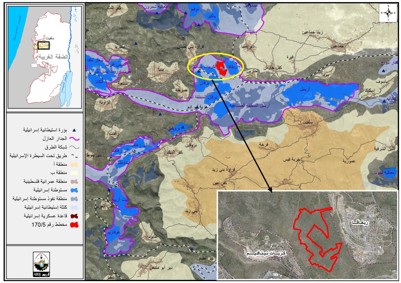
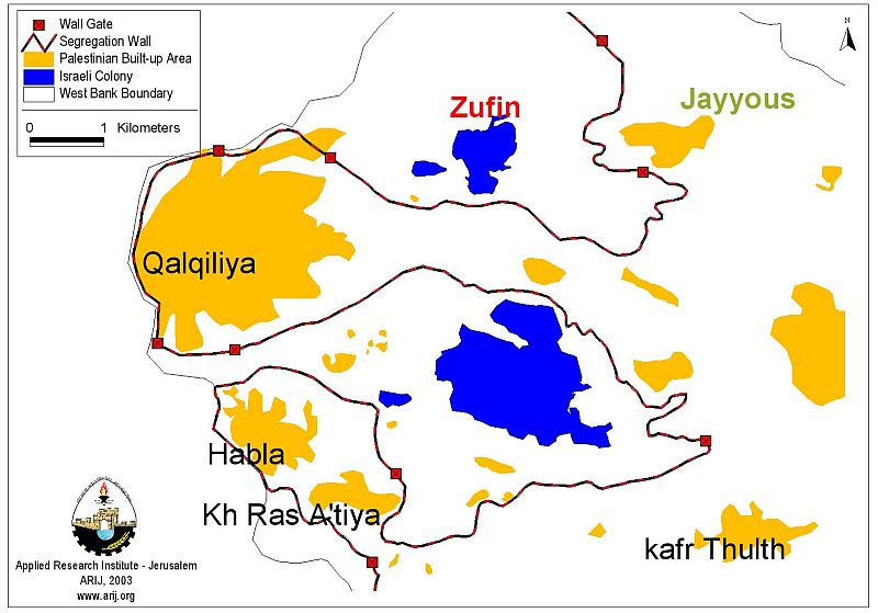
The village of Jayyus is located northeast of Qalqiliya city. The village has a population of approximately 3,200 people and comprises a built-up area of around 490.6 dunums (0.5 km2). Jayyus village lands comprise 12,500 dunums (12.5 km2) from which 8,374.6 dunums (8.4 km2) are isolated by the Segregation Wall. See map one.
For more information see: (Click to see))
The illegal Israeli settlement of Zufin lies a few kilometers west of the village. The settlement was founded in 1990 and originally covered an area of 1.6 km2 of Palestinian lands near Jayyus. Today the settlement covers 8.1 km2 (an increase of over 400%) and has a population of 850 Israeli settlers (see Charts One and Two below). Currently, Israel is reportedly expanding the settlement over an additional 850 dunums (0.85 km2) of confiscated lands.
Chart One: Territorial Expansion of Zufin settlement (1990-2003)
|
|
1990 |
1996 |
2000 |
2001 |
2002 |
2003 |
2004 |
|
Area (km2) |
1.6 |
2.3 |
2.7 |
3.8 |
6.2 |
8.1 |
11.6 |
|
Area (dunum) |
162.3 |
229.3 |
273.7 |
380 |
615 |
811 |
1156 |
|
Settlement Expansion |
N/A |
41% |
20% |
39% |
38% |
32% |
43% |
|
Total Expansion (1990-2003): 10 km2 (625%) |
|||||||
Chart Two: Population growth of Zufin settlement (1992-2001)
|
|
1992 |
1996 |
1998 |
1999 |
2000 |
2001 |
2004 |
|
Population |
300 |
693 |
759 |
788 |
818 |
850 |
1040 |
|
Population Growth |
N/A |
131% |
9.5% |
3.8% |
3.8% |
4% |
22.4% |
|
Total Population Growth (1992-2002): 740 people (246.7%) |
|||||||
Actions of Israeli Occupation Authorities in Jayyus until 2002:
-
In 1989, Israeli occupation forces confiscated 1,362 dunums of Jayyus village lands belonging to 79 Palestinian farmers. The lands were confiscated for the purpose of constructing Zufin settlement, its by-pass road, buffer zones, and of providing the settlement with water and other basic services. (Military Order number 36/89).
-
Residents of Jayyus appealed the decision and an Israeli Military Court ruled on May 28, 1996 that 61 of the 79 farmers would able to keep their land. Among the lands that were retained by village residents were 31 dunums (0.3 km2) belonging to the Salim family, most of which was cleared by the Israeli occupying forces between December 9 and 20, 2004.
-
In 1993, the Israeli occupying forces began to clear additional areas of confiscated land to use as a rock quarry. The quarry lies 3 km northeast of Zufin settlement and surrounds most of the lands owned by the Salim family of Jayyus. Israel expanded the quarry systematically to isolate the lands of Jayyus farmers retained in the 1996 appeal. It now comprises nearly 300 dunums (3 km2) of village's lands.
-
In late 2000, Israeli occupying forces established a 'military training base' on lands near the quarry and north of Zufin settlement. The 'military training base' is used as a pretext for Israeli soldiers to harass farmers and periodically restrict access to the affected lands.
-
In September 2002, Israeli occupying forces distributed military orders informing Jayyus residents that their lands would be confiscated for constructing the Segregation Wall around Jayyus. Construction of the Wall began on September 25, before the closing of the 40 day appeal period granted by domestic Israeli law.
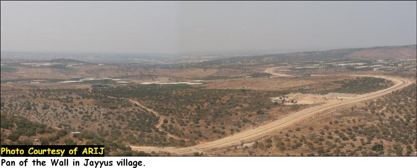
The Segregation Wall in Jayyus:-
Jayyus, like many Palestinian localities on the western flank of the West Bank, has been severely impacted by Israel's Segregation Wall. In 2002, 550 dunums (55 km2) of Jayyus lands were destroyed to construct the Wall and buffer zones. At least 70%, 8,374.6 dunums (8.4 km2), of Jayyus village lands are now isolated on the western side of the Wall The six artesian wells that the village has traditionally depended on for its water supply are also on the other side of the Wall.
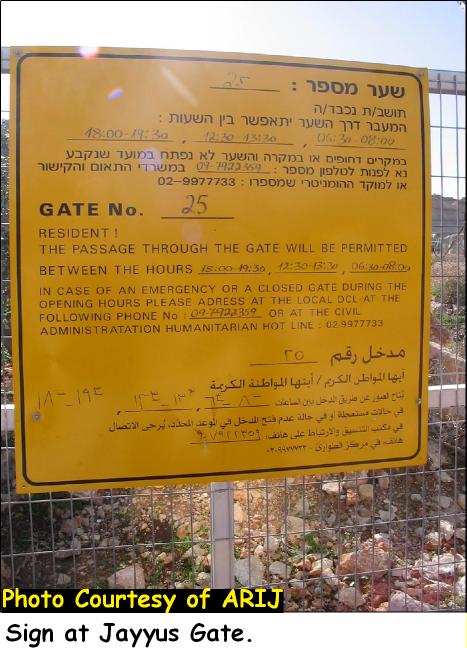
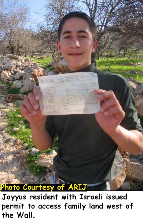
Landowners in Jayyus are required to apply for Israeli issued permits (Tasreeh) in order to access their lands on the other side of the Wall. The village depends almost exclusively on its agricultural production but only 7% of village residents have been granted permits to work in their lands. The permits must be renewed every six months and Israeli occupation authorities can revoke permits without explanation. There are two gates in the Wall which Israeli occupying forces open two or three times daily to allow access to those Palestinian farmers with permits. Signs posted near the gates state that they are open from 18:00-19:30, 12:30-13:30 and 06.30-08:00. Jayyus farmers, however, report that the gates are usually open for shorter times and sometimes remain closed for long periods, making it extremely difficult to work in the land and transport goods to markets. Approximately 15,000 citrus trees have died since the Wall was built because farmers were denied access to their groves and were unable to tend the trees.
Many of the farmers who were denied permits are in danger of losing their lands to the Israeli state. Israel has employed the Ottoman Land Law of 1858 all over the Occupied Palestinian Territories (OPT) in order to appropriate thousands of kilometers of Palestinian lands. The Ottoman law allows the state to confiscate any lands that have not been worked or developed for three consecutive years. Palestinian farmers who are denied permits by Israeli occupying forces cannot work in their land, which means that in three years (possibly as early as September 2005 in Jayyus) it could be confiscated by Israel. For more information see: (Click Here)
The Current Expansion of Zufin settlement:
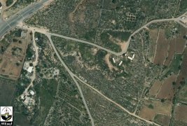
On December 9, 2004 Israeli bulldozers from the Israeli LIDAR Corporation began to uproot Olive trees and clear additional areas of Palestinian land west of the Segregation Wall in Jayyus. The bulldozer uprooted 117 trees the first day and returned on December 10,11, 19, and 20 to uproot more trees. At the end of the period approximately 750 Olive trees had been uprooted and approximately 24 dunums of Palestinian land had been cleared. The trees were loaded into Israeli trucks bearing Israeli license plate numbers 33, 294, 00 and 55, 00, 27 and taken to Israel to be sold.

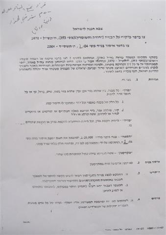
Jayyus farmers petitioned Israeli occupation forces to stop the destruction and were given a new map of the area. Apparently, a branch of the Israeli occupation bureaucracy, the Primary Committee for Registering untransferred Properties made a secret decision on November 13, 2000. The decision came in response to the villagers' appeal in 1996. The registration certificate (sales transaction number 2/2003) claims that two properties numbered 786 and 788 were sold by a resident of Jayyus. The two properties are not located near the bulldozed area. In fact, the two parcels are each on different sides of the land and separated from each other by nearly 3 km. Residents of Jayyus were not informed of the decision and were only given the registration certificate and a map on December 15, 2004.
The new map was dated December 29, 2002 (more than two years after issuance of the registration certificate) and did not correspond to the original maps of the land. Numbers defining the parcels of land on the new map had been changed to correspond with the registration certificate. Analysts have concluded from the map that Israel unilaterally re-zoned the areas of Palestinian land affected.
Parcels that were under Palestinian ownership were re-zoned as state land or land under Israeli title. The land Israel cleared between December 9 and 20, 2004, belonging to Tawfiq and Jameel Salim, which was originally recorded as parcel 32, had been re-zoned as parcels 786 and 788. These two parcels are actually nearly 3 km apart and do not even border parcel number 32.
The Salim family holds title to 86 dunums in the affected area. However, 55 dunums were confiscated by Israel in 1989, leaving only 31 dunums. Most of the remaining land was targeted by the recent re-zoning and cleared of trees. Tawfiq Hasan Salim lost all 24 dunums of his land and 500 olive trees, Jameel Salim lost 200 trees and Abdel Fatah Salim lost 50 trees. The average age of the uprooted olive trees was 32 years. The loss of the land is devastating for the family. Tawfiq Salim has 7 sons (including 2 in university) and 3 grandchildren in his family. He has no other farmland and few options for providing for his family. In his testimony given to ARIJ, Salim stated: 'There is no cost for what I have lost. I lost my life growing these trees.'
The re-zoning of the Salim family's land has allowed Israeli occupation authorities to push forward with plans for the construction of the Zufin North settlement. The stone quarry Israel began in 1993 surrounds most of the area and isolated more than 20 dunums belonging to Tawfiq Salim. The quarry is cut into the hillside leaving embankments up to 18 meters along the edges of the parcel. The confiscation of this land now opens up the entire area for construction. Residents report that temporary street signs in Hebrew have been placed in the ground on the quarry floor, including one sign that reads 'Sharon Street.' An analysis of satellite images of the affected area suggests that the initial size of the new settlement will exceed 345 dunums (3.5 km2).

The Expansion of the Illegal Israeli Settlements and the Segregation Wall
Israel's Segregation Wall is a blatant violation of international law and an affront to the human and national rights of the Palestinian people. However, Israel has attempted to justify the Segregation Wall project by explaining that it is a defensive measure and a temporary barrier that can be removed. The construction of the illegal Zufin North settlement on Jayyus village lands west of the Segregation Wall, however, demonstrates that Israel's intention in building the Wall is to grab additional areas of Palestinian land. Israel has used its settlements and the Segregation Wall as political tools to exercise control over Palestinian land. When completed, the Wall will stretch approximately 685 km and appropriate approximately 50% (2669 km2) of the West Bank and includes 90% of Israeli settlements in the OPT.
The settlement expansion aims to consolidate Israeli control over Palestinian land in the Seam Zone between the Segregation Wall and the Green Line (the internationally recognized border between Israel and the West Bank). In some cases, these settlements reach far into the West Bank along the route of the Wall. The site of the new Zufin North settlement is nearly 5 km from the Green Line. Israel is currently expanding every settlement in the Qalqilya District, including Zufin, Alfe Menshae, Oranit, Elkana, Etz Efrayim, Sha'are Tikva and Qedumim.
The case of Zufin North demonstrates Israel's insistence on appropriating this area at any cost, including land theft. Israel is attempting to use the illegal physical barrier of the Segregation Wall as a de-facto political barrier allowing it to appropriate occupied Palestinian land in the OPT. Many Palestinian farmers and advocates fear that Israel will continue to tighten restrictions on Palestinian access to lands west of the Wall while simultaneously expanding its settlement infrastructure in the area.
Palestinian and Israeli Demonstrations and Civil Disobedience to Stop the New Settlement
|
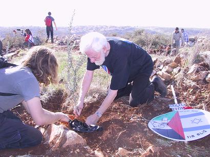
On Friday, December 31, 2004 Israeli and international activists from more than 15 nations around the world joined the people of Jayyus in a nonviolent protest and act of civil disobedience. A convoy of buses and private cars brought approximately 200 Israeli activists from inside Israel to Jayyus land west of the Segregation Wall. The convoy was stopped by Israeli occupying forces before reaching the area and the people were forced to walk 6 kilometers along the dirt tracks to the cleared area accompanied by around 50 jeeps of the Israeli army and Border Police.
The Israeli activists carried olive saplings to the land of Tawfiq Salim where they were met by approximately 30 Palestinian farmers from Jayyus and 9 international activists who had slept on the land the previous night. The group planted 100 olive saplings where the older trees had been uprooted and held a spontaneous rally. Israeli occupying forces announced that the land was 'private property belonging to the settlers, and the planting of olive trees here is a violation of the [Israeli] law.' Israeli soldiers photographed the faces of the activists as they planted the trees.
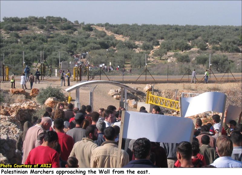
Meanwhile, nearly 250 villagers from Jayyus gathered in the center of the village. The villagers were joined by approximately 25 international activists and a group of Israeli colleagues as they marched from the village to the gate in the Segregation Wall on the northern edge of the village (Gate number 25). The two groups approached the gate simultaneously from opposite directions and attempted to reach the gate. The two sides stood on opposite sides of the Wall with approximately 100 Israeli soldiers and Border Police between them.
Palestinian marchers approaching the Wall from the East
Israeli activists replanting Olive Saplings in Jayyus village – Qalqilyia
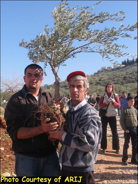
The Two sides chanted together and attempted to reach the gate. Israeli occupying forces pushed them back but eventually allowed a delegation of three Israeli activists through to the eastern side of the Wall. The Israelis carried a small Olive tree that had been uprooted and left on the land. As they crossed through the gate they were met with loud cheers and applause from the Palestinian group. The delegation was swarmed by the Palestinian marchers, exchanging warm embraces. They granted the Olive tree to Tawfiq Salim as a symbol of peace and solidarity between Israelis and Palestinians.
Tawfiq Salim -right- with the uprooted olive tree brought to him by the Israeli delegation. |

Israeli Settlements in International Law
-
Israel's settlements in the Occupied Palestinian Territories (OPT) violate numerous United Nations Security Council and General Assembly Resolutions. United Nations Security Council Resolution 242 (1967), drafted immediately after Israel occupied the West Bank and Gaza Strip, demands 'the withdrawal of all Israeli armed forces from the territories occupied' in the war.
-
The requirements of Resolution 242 are re-enforced and strengthened by UN Security Council Resolutions 452 (1979) and 465 (1980). Resolution 452 calls upon 'the Government and people of Israel to cease, on an urgent basis, the establishment, construction and planning of settlements in the Arab territories occupied since 1967, including Jerusalem.' Resolution 465 states categorically that:' all measures taken by Israel to change the physical character, demographic composition, institutional structure of status of the Palestinian and other Arab territories occupied since 1967, including Jerusalem, or any part thereof, have no legal validity and that Israel's policy and practices of setting parts of its population and new Immigrants in those territories constitute a flagrant violation of the Fourth Geneva Convention Relative to the Protection of Civilian Persons in Time of War and also constitute a serious obstruction to achieving a comprehensive, just and lasting peace in the Middle East.'
Israel's settlement policy is also a flagrant violation of international humanitarian law, specifically the Hague Regulations of 1907 andthe Fourth Geneva Convention of 1949.
-
The Hague Regulations expressly forbids an occupying power 'to destroy or seize the enemy's property, unless such destruction or seizure be imperatively demanded by the necessities of war' (Article 23).
-
The Fourth Geneva Convention, the primary document of international law governing instances of military occupation, states in Article 49 that: 'The occupying power shall not deport or transfer parts of its own population into the territories it occupies.'
-
Article 53 of the Fourth Geneva Convention is also clear that: 'any destruction by the Occupying Power of real or personal property belonging individually or collectively to private persons, or to the State, or to other public authorities, or to social or cooperative organizations, is prohibited, except where such destruction is rendered absolutely necessary by military operations.'
-
The appropriation and destruction of Palestinian land is an especially serious violation of the Fourth Geneva Convention, Article 147 of which clearly prohibits, ''extensive destruction and appropriation of property, not justified by military necessity and carried out unlawfully and wantonly.'' Violations of Article 147 constitute grave breaches of the Convention and should be prosecuted as War Crimes.
Conclusion:
The establishment of a new settlement on land belonging to the Palestinan villagers of Jayyus is a clear violation of international law, including numerous United Nations Resolutions and crucial provisions of the Hague Regulations of 1907 and the Fourth Geneva Convention of 1949. The Fourth Geneva Convention expressly categorizes such actions as War Crimes (Article 147). In addition, by failing to conform to international legal standards and the rule of law, Israel's actions are seriously jeopardizing the viability of any future peace agreement in the region.
The construction of the illegal Zufin North settlement on Jayyus village lands west of the Segregation Wall demonstrates that Israel's intention in building the Wall is to appropriate additional areas of Palestinian land. The construction of new settlements and expansion of existing settlements in the Seam Zone (between the Wall and the Green Line) is intended to consolidate Israeli control over occupied Palestinian land in the area. Since its founding in 1990, Zufin settlement has expanded by over 400%. In fact, Israel's settlements have consistently expanded every year following the seizure of the OPT in 1967.
Israeli occupying forces have done everything in their power to appropriate additional Palestinian lands for the construction of illegal Israeli settlements. The unilateral re-zoning of the Salim family land in Jayyus is a contravention of international law and a violation of the Israeli military laws directing the illegal occupation of the OPT. Jayyus farmers are preparing to bring the case to the Israeli Supreme Court. They have requested a meeting with the Special Investigation Unit of the Israeli Police to look into the zoning inconsistencies. The Israeli Police, however, have refused to visit the site or hear the farmers' arguments.
|
The illegal construction of the Zufin North settlement is an example of Israel's expansionist aims in the Qalqiliya District and throughout the OPT (Occupied Palestinian Territories). The nonviolent demonstration and civil disobedience action on December 31st has generated a substantial amount of media attention and continued a long tradition of joint Israeli-Palestinian solidarity work in Jayyus. The people of Jayyus have welcomed the Israeli activists with open arms. In the words of Tawfiq Salim: 'When I met [the Israeli activists] I felt that there are people [in Israel] who believe in justice and believe in the law. I felt that [there are people] who will fight and struggle with us for solidarity and for justice.'
|
References:-
-
[1] According to the Palestinian Central Bureau of Statistics (PCBS) the population was 2,927 in 2002 (www.pcbs.org.ps). Village residents placed the population at 3,300 in January 2005.
-
[2] ARIJ GIS Database, 2003.
-
[3] Ibid.
-
[4] Bloom, David. 'West Bank Apartheid: Israeli Settlement Expansion in Jayyous.' ZNet (posted at http://stopthewall.org/analysisandfeatures/835.shtml), 15 December 2004.
-
[5] ARIJ GIS database 2003.
-
[6] Peace Now (www.PEACENOW.org).
-
[7] ARIJ GIS Database, 2003.
-
[8] The family that sold parcels 786 and 788 submitted an appeal to the Palestinian District Court in Nablus arguing that they had been deceived by the buyers and the sale was invalid. The court granted the appeal and registered the land in the name of the original Palestinian owners. Israeli occupation authorities, however, refuse to consider the rulings of Palestinian courts. According to Israeli Military Order 1060, Palestinian courts have no authority of real estate transactions in the OPT.
-
[9] Press Release. The Israeli Coalition Against Home Demolitions. December 31, 2004.
Prepared by:
The Applied Research Institute – Jerusalem