In June 29, 2004, the Israeli High Court ordered a halt to the construction of a 30 Kilometer section of the Segregation Wall affecting nine Palestinian villages. The villages, Beit Surik, Biddu, Qattana, Al Qubeibeh, Beit Anan, Beit Leqia, Beit Duqqu, Beit Ijza, Neve Samuel and Beit Iksa, are located north and northwest of Jerusalem. The court's order came as a result of an appeal presented by Palestinian residents of the nine communities. The residents filed suit in an attempt to preserve their rights under international law and domestic Israeli law and to challenge the Wall's location which isolated them from neighboring Palestinian areas in the West Bank.
The Israeli High Court Ruling:
Israel's High Court specified that certain changes should be made in the wall's route in order to address humanitarian concerns and the rights of the affected communities. The court ruled that:
-
The Segregation Wall is legal under domestic Israeli law but the path along the in north and northwest Jerusalem should be changed to address humanitarian concerns.
-
Israeli military planners designing the Wall must attempt to minimize the humanitarian impact on Palestinians civilians living in the nine villages and plan the route of the Wall according to 'the proper balance between security and humanitarian considerations..'.
The Israeli High Court declined to rule on the entire Segregation Wall project, but restricted its ruling to the 30 kilometers section affecting the 9 villages. The Court also failed to suggest a new route for the wall or set a timeline for the changes to take place. These decisions were left to Israeli occupation authorities. The court also neglected the relevant articles of international law which would suggest that the Wall's route be redrawn along the internationally recognized 1967 borders (the Green Line) between Israel and the Occupied Palestinian Territories (OPT).
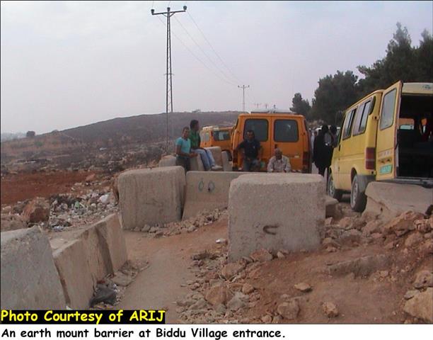
Partially completed sections of the Segregation Wall can be easily seen as one enters Biddu village where an earth mount barrier exists at it's entrance and separates the villages of Beit Surik, Biddu, Qattana, Al Qubeibeh, Beit Anan, Beit Leqia, Beit Duqqu, Beit Ijza, Neve Samuel and Beit Iksa from the regional commercial and cultural center in Ramallah (Click on links marked with blue for more details).
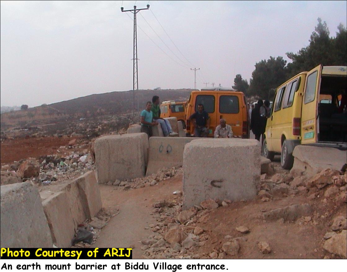
Picture 1: An earth mount barrier at Biddu village entrance.
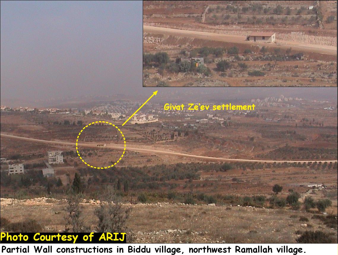

Picture 2 & 3: A partial completed wall as seen from Biddu and Beit Ijza villages
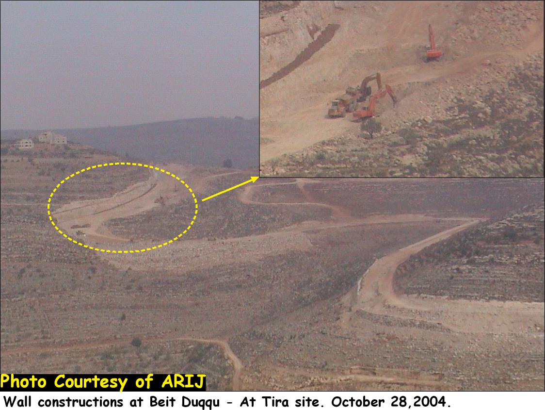
Picture 4: A partial completed wall as seen from Beit Duqqu village
Recently, the Israeli Occupation forces distributed three new military orders (Military order n0 04/75/T, Military order n0 04/75/T and Military Order n0 04/75/T) to Palestinians living in the above mentioned villages stating a new route of the Segregation wall to be implemented and differs from that published at the ministry of defense webpage on June 30, 2004.
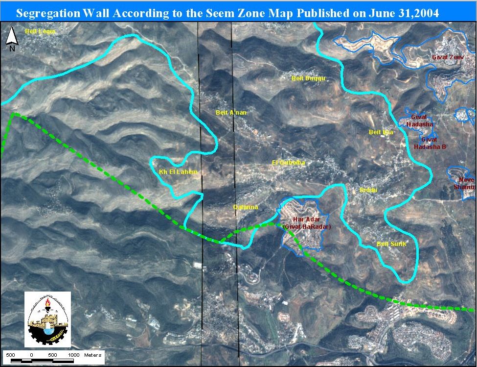
Map 1
An analysis of the new Israeli military orders and satellite images of the targeted villages demonstrates that the current path of the Segregation Wall will result in the confiscation of a total land area of 840 dunums and runs a length of 14 kilometers. The Wall also appropriates large segments of Palestinian land, cutting it off from the villages and enclosing it in Segregation Zones. Despite changes made in the route, the new orders do not move the Wall to the Green Line (1948 Armistice line and the internationally recognized border). Below is a detailed description of the military orders:
1. Military order n0 04/75/T;-
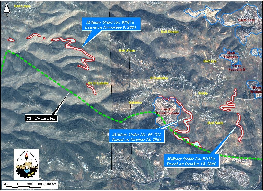
Military order number 04/75/T specifies that the Wall will cut within 180 meters of Palestinian homes (1000 meters away from the Green Line) in Biddu village. Some sections of the wall will be set exactly on the Green Line whereas other sections reach as far as 1000 meters into the occupied West Bank. As a result, the Wall will have the effect of dramatically redrawing the border between Israel and the West Bank in order to annex the illegal Israeli settlement of Har Adar as shown in Map 2 below. .
Below is a translation of the military order to the English language:
|
Israel Defense Forces
According to my authorities as a Military Chief Commander in the Region of Judea and Samaria, and as I believe that it is imperative for military reasons due to the special security situation in the region, I order the following: 1. The ''Map'' signed in scale 1: 10000 and attached to the order is an essential part of this order. The ''Lands'' : An area of land which is 336.1 dunums (3815 meters long and 220 meters wide) marked in red in the map : Al Qubeibeh: Block 2: Kherbit Beit Shabab. Biddu: Block 2: Kherbit Najim area Beit Surik: Block 5: Kherbit Al Murin
2. I announce by that the above mentioned lands are seized for military reasons 3. The IDF seize the lands and have an absolute control over it that is given to the officer of the central command officer of lands who is responsible in the ministry of defense. 4. These copies are to be given by the District Co-ordination Office ''The DCO'' of Ramallah to the owners of land. 5. A) The announcement of this order to be distributed to land owners through the DCO in Ramallah district, hanging them on trees at Palestinian lands and farms or by any mean possibel 6. Copies are found with maps for those who are interested in the following places: · DCO of Ramallah. · Offices of the Juridical advisor in the region · The office of commander responsible in the ministry of defense in the civil administration. · Office responsible of absentee and public lands in the civil administration. 7. Owners of land have the right to object the order in 7 days after the visit mentioned in item (5.A) through the DCO in Ramallah or through the judicial advisor of the area. 8. The Validity of this order starts at the date signed till 31/12/2007. 9. The name of this order is: ''Order to seize lands n0 04/75/T (Judea & Samaria) 2004.
Moshe Kaplenski |
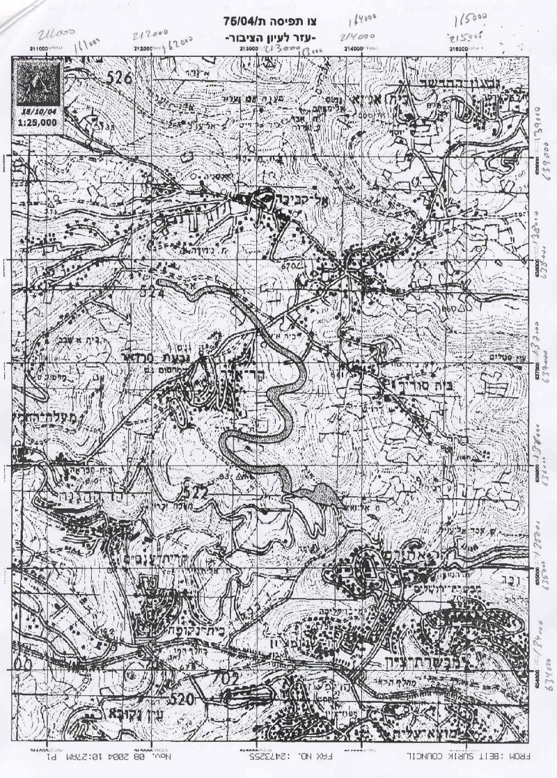
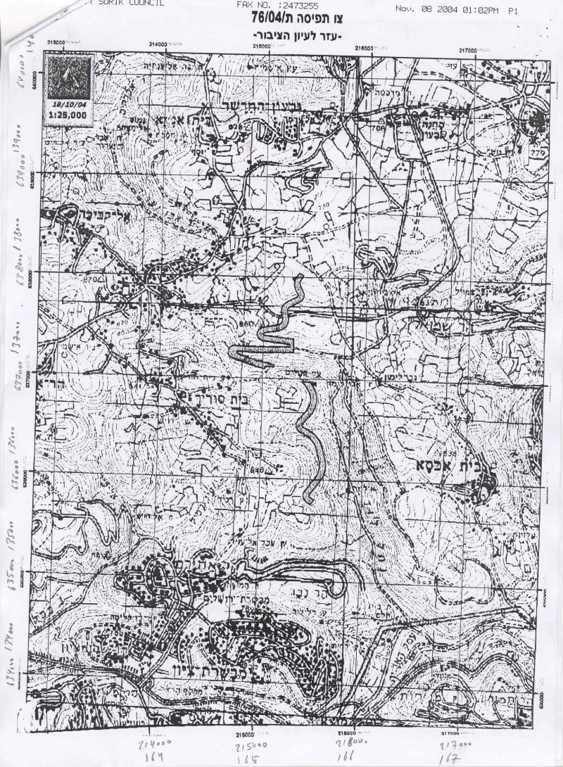
2. Military order n0 04/76/T:-
Military order number 04/76/T will cut within 600 meters of homes in Beit Surik village. The new sections of the Wall in this area include gaps between sections. These gaps may allow Israeli occupying forces to construct additional Wall components at a later date. See Map 2. .
Below is a translation of the military order to the English language:
|
Israel Defense Forces
According to my authorities as a Military Chief Commander in the Region of Judea and Samaria, and as I believe that it is imperative for military reasons due to the special security situation in the region, I order the following: 1. The ''Map'' signed in scale 1: 10000 and attached to the order is an essential part of this order. The ''Lands'' : An area of land which is 263.7 dunums ( out of which 41.7 are state land) marked in red in the map : Beit Surik: · Block 4: Kherbit Al Jabal. · Block 3: Wadi Al Jouz, Shu'ab Al Dahur Beit Iksa: · Block 6: Hareqat Al 'Aqab, 'Ein Al 'Aleiq, Zaquq Al Huseni. · Block 7:Thaher Badu, Nabus Hatab. · Block 8: Hareqat Al 'Arab, Qat'at Atbeesh. Biddu: · Block 3: Arjaman. Neve Sameul · Block 2: Thar 'Imran.
2. I announce by that the above mentioned lands are seized for military reasons 3. The IDF seize the lands and have an absolute control over it that is given to the officer of the central command officer of lands who is responsible in the ministry of defense. 4. These copies are to be given by the District Co-ordination Office ''The DCO'' of Ramallah to the owners of land. 5. A) The announcement of this order to be distributed to land owners through the DCO in Ramallah district, hanging them on trees at Palestinian lands and farms or by any mean possibel 6. Copies are found with maps for those who are interested in the following places: · DCO of Ramallah. · Offices of the Juridical advisor in the region · The office of commander responsible in the ministry of defense in the civil administration. · Office responsible of absentee and public lands in the civil administration. 7. Owners of land have the right to object the order in 7 days after the visit mentioned in item (5.A) through the DCO in Ramallah or through the judicial advisor of the area. 8. The Validity of this order starts at the date signed till 31/12/2007. 9. The name of this order is: ''Order to seize lands n0 04/76/T (Judea & Samaria) 2004.
Mosheh Kaplenski |
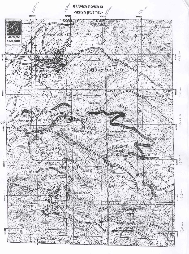
3. Military Order n0 04/87/T
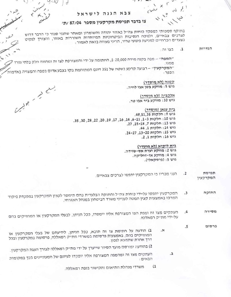
Military order number 04/87/T is a special case in that:
1) It severely affects the village of Kherbit Um Al Lahem (west of Beit 'Anan) due to the village's location close to the Green Line; and will cut within 30 meters of residents' homes located at least 700 meters from the Green Line.
2) A longer section of the Segregation Wall will be built on the lands of Beit 'Anan, a full 1,700 meters away from the Green Line; and will cut within 1,000 meters of the village's built up area. See map 3.
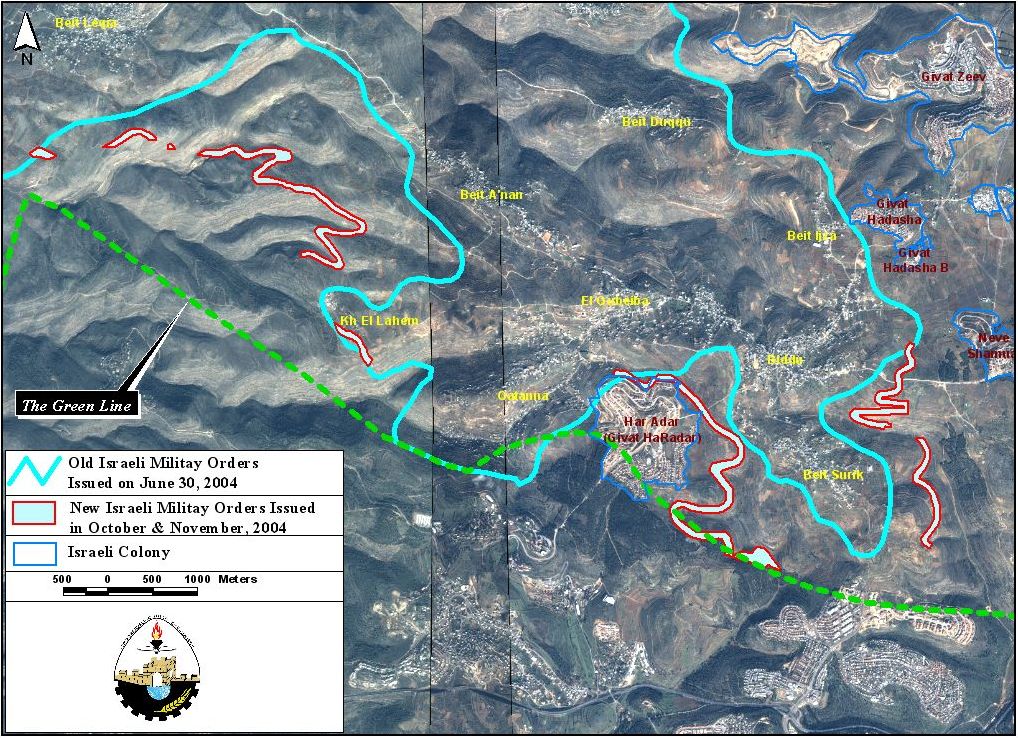
Map 3: Old and new route of the Wall in villages located northwest Ramallah city
Below is a translation of the three military orders to the English language:
|
Israel Defense Forces
According to my authorities as a Military Chief Commander in the Region of Judea and Samaria, and as I believe that it is imperative for military reasons due to the special security situation in the region, I order the following: 1. The ''Map'' signed in scale 1: 20000 and attached to the order is an essential part of this order. The ''Lands'' : An area of land which is 351 dunums (3815 meters long and 220 meters wide) marked in red in the map : Qatannah: Block 5: Baten Abu Lehya. Al Qubeibeh: Block 10: Beir Abu Tur. Beit 'Anan: · Block 9: Parcel:35,51,49 · Block 10: Parcel:1-2, 6-11, 14,17-19,20, 22, 28, 30-35 · Block 13: Parcel: 7, 15-18, 27. · Block 14: Parcel:1,44. · Block 15: Parcel: 13-20, 24-27. · Block 16: Parcel: 1, 2. 2. I announce by that the above mentioned lands are seized for military reasons 3. The IDF seize the lands and have an absolute control over it that is given to the officer of the central command officer of lands who is responsible in the ministry of defense. 4. These copies are to be given by the District Co-ordination Office ''The DCO'' of Ramallah to the owners of land. 5. A) The announcement of this order to be distributed to land owners through the DCO in Ramallah district, hanging them on trees at Palestinian lands and farms or by any mean possible. 6. Copies are found with maps for those who are interested in the following places: · DCO of Ramallah. · Offices of the Juridical advisor in the region · The office of commander responsible in the ministry of defense in the civil administration. · Office responsible of absentee and public lands in the civil administration. 7. Owners of land have the right to object the order in 7 days after the visit mentioned in item (5.A) through the DCO in Ramallah or through the judicial advisor of the area. 8. The Validity of this order starts at the date signed till 31/12/2007. 9. The name of this order is: ''Order to seize lands n0 04/87/T (Judea & Samaria) 2004.
Moshe Kaplenski |
The issued military orders are creating a completely new set of 'facts on the ground' by permanently annexing more lands of the West Bank, ethnically disconnecting the targeted villages from Ramallah and Jerusalem, the two urban centers which they relied upon, segregating the villages from their agricultural lands close to the Green Line, and illegally extending Israeli territorial authority over large sections of Palestinian land in the West Bank. The impact of the Wall will lead to further economic and environmental devastation, increasing levels of poverty, and increasing despair and desperation among Palestinians as they witness Israeli occupation authorities appropriate more land for the construction of the Segregation Wall.
[1] 840,000 square meters or 210 acres.
Prepared by:
The Applied Research Institute – Jerusalem


