• About The Project
  • Palestine in Century
  • Selected Maps
  • Glossary
  • About ARIJ
  • About LRC
  • By Year
    • Case Studies By Year
    • Daily Report By Year
Sunday, May 25, 2025
POICA
No Result
View All Result
  • Home
  • Settlements
    • New Israeli Settlements
    • Settlement Expansion
  • Israeli Violations
    • Agriculture
    • Confiscation
    • Demolition
    • Environment
    • Eviction of Palestinians
    • Settlers Attacks
  • Bypass Roads
  • Israeli Plans
  • Segregation
    • Checkpoints
    • Closure
    • Separation Plans
  • Military Orders
  • Reports
    • Daily Report
    • Monthly Report
    • Quarterly Report
No Result
View All Result
POICA
No Result
View All Result

The Segregation Separation Wall hits the lands of Surif and Khibet Ad Deir- Hebron district

October 20, 2004
in Segregation
The Segregation Separation Wall hits the lands of Surif and Khibet Ad Deir- Hebron district


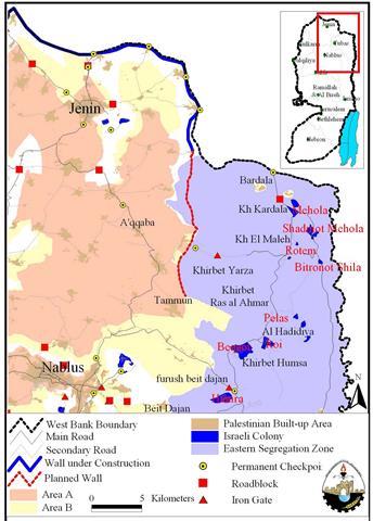
Location and population

The village of Surif is located 16 km to the north west of Hebron city and about 6 km from the green line. It has the population of about 15 000 inhabitants, mostly working in agriculture, particularly olive trees as the climate and soil in this town is very ideal for olive growing. This characteristic has made Surif famous of good quality olive oil.

Khibet Ad Deir is located to the west of Surif and inhabited by extended families from mother village of Surif. It is almost located on the green line with a population of about 300 people.


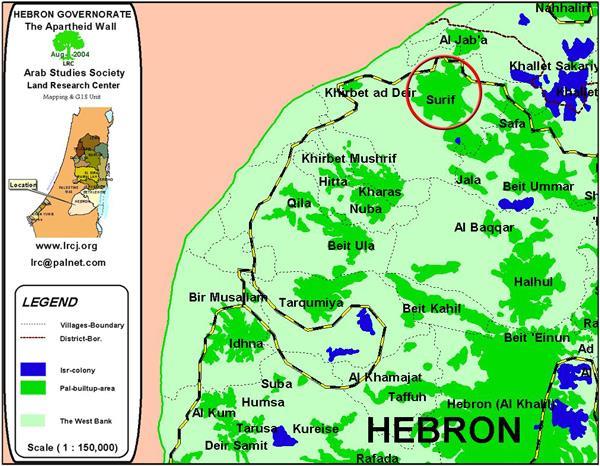
Map 1- Location map of Surif and Ad Deir


On October 3rd, 2004, the Israeli army started to bulldoze hundreds of fertile agricultural lands to the west of Surif and Khirbet Ad Deir villages in the north west corner of Herbon district for the purpose of constructing the Segregation Separation Wall. The devastation works are being carried out in the areas of Wadi As Sur, Khirbet Ad Deir and Khalet Al Ghurus at the depth of 200-300 meters in the Palestinian land to the east of the green line. 


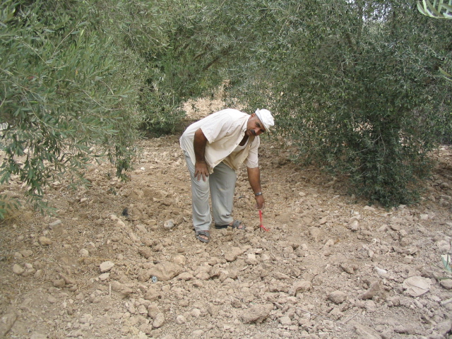
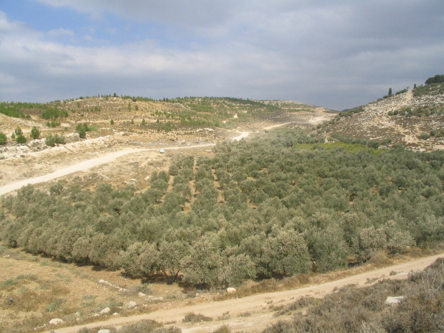
Picture 1- Wadi As Sur- Khirbet Ad Deir- Surif- Hebron:
A Palestinian farmer pointing to a sign fixed by Israeli surveyors in the middle of his olive field-  
Photo courtesy of LRC)


At the end of last July, the Israeli military issued order  number T/64/4 to confiscate not less than 500 dunums form the lands of Surif, Nuba and Beit Ula to make space for the Wall construction. In reality, the area of land targeted for confiscation or separation is much bigger than that mentioned in the foresaid order.  For example, the Surif village and Khirbet A Deir alone will loose about 500 dunums, according to the head of Surif municipality, Mr. Mohammed Barath'iya, who confirmed that the targeted land is the most fertile in the town and considered the only source of living for many families.  


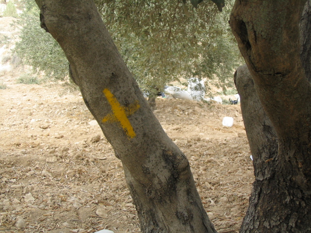
Picture 2- Wadi As Sur-  Khirbet Ad Deir – Surif:
Trees marked with yellow crosses prior to uprooting-
Photo courtesy of LRC

Amongst those affected are the following:


Owner name

Area in dunums

1

Ibrahim Mohammed Salamn Barath'iya

3

2

Khalil Mohammed Salman Barath'iya

29

3

Sharif Mohammed Salman Barath'iya

9

4

Jamil Mohammed Salman Barath'iya

10

5

Mahmud Mohammed Salman Barath'iya

6

6

Mohammed AbdulHadi Barath'iya

8

7

Awad Mahmud AbdulHadi Barath'iya

8

8

Salman AbdulHadi Barath'iya

30

9

Amin Omer 'Abed

15

10

Ziyad Ezzat Abu Fara

3

11

Musa Abdulllah Abu Fara

3

12

Abdul Qader Ali Barath'iya

6 & a cistern

13

Ahamd Ali Barath'iya

8

14

Sami Naji Barath'iya

6

15

Mahmud AbdulAziz Ihdush

6

16

Yusif AbulAziz Ihdush

6

17

Khalil Saber Abu Fara

10

18

Salah Saber Abu Fara

10

19

Ra'id Al Hieh

2

20

Khalil Mohammed Salim Al Hieh

2

21

The sons of Shaker Al Hieh

4

22

Ibrahim Bahjat Abu Fara

2

23

Isa Mohammed Ibrahim AlHieh and brothers

4

24

Waheeb Ibrahim Adwan

6

25

Mahmud Adwan

8

26

Sameer Al Qadi and brothers

5

27

Musa Ibrahim Abu Fara

3

28

Awad Mahmud Barath'iya

6

29

Abdul qader Ali Salman 'Afana

6

30

Hasan Shaker Al Hieh

4

31

Abdul Hamid Salman Barath'iya

2

32

Ibrahim Hammad Abu Fara

5

33

Bader Al Ghuruz and brothers

100


335


The Israeli military forces maintain heavy presence in the area and prevent accessibility to the targeted lands. A number of farmers confirmed that when they tried to pick the already ripe olive harvest, the Israeli soldiers forced them out of their land, beaten some of them and detained others for long hours. Most of the lands are planted with fruitful olive trees of very good type, including the old Ruman densities. The olive picking season has already started in the West Bank at the beginning of this month, however, farmers from these two villages whose lands are close to the green line are unable to collect their harvest for the aforementioned reasons.  The total of about 5000 olive trees will eventually be uprooted or separated by the construction of the Wall in these tow villages.

The land owners have objected to the confiscation orders and the devastation of their land  through the lawyers appointed by the Land Defense Committee in Hebron, yet to no avail.      


Picture 3: Khirbet Ad Deir- Surif:
The olive field to the right will be totally devastated by the construction of the Segregation Wall – Photo courtesy of LRC


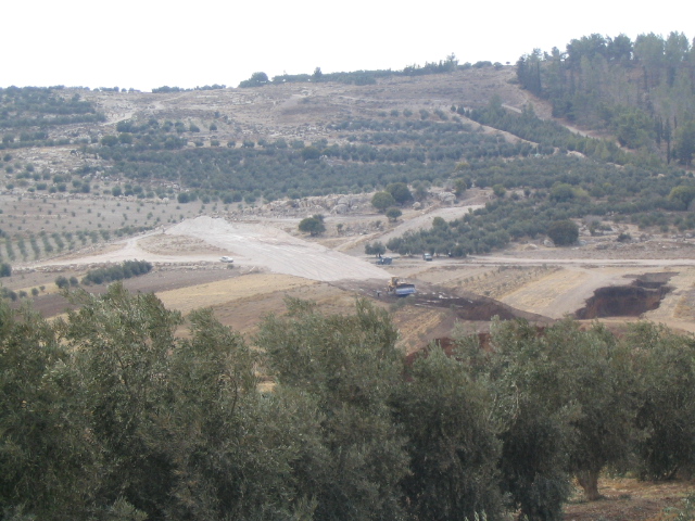
Picture 4: Khirbet Ad Deir- Surif:
An Israeli bulldozer cutting through fertile Palestinian land – Photo courtesy of LRC


Prepared by
The Land Research Center
LRC

Recommended For You

سلطات الاحتلال الإسرائيلي تفرض واقعا جيوسياسيا جديدا في منطقة شمال قطاع غزة المحتل

by arij
March 13, 2024
0
سلطات الاحتلال الإسرائيلي تفرض واقعا جيوسياسيا جديدا في منطقة شمال قطاع غزة المحتل

  أظهرت صور الأقمار الصناعية الصادرة عن برنامج مراقبة الأرض التابع للاتحاد الأوروبي (كوبرنيكوس) لقطاع غزة المحتل في العاشر من شهر اذار من العام 2024، ان سلطات الاحتلال...

Read moreDetails

الحرب على قطاع غزة وتأثيرها على محافظة الخليل جنوب الضفة الغربية

by arij
November 30, 2023
0

  تقع محافظة الخليل في الجزء الجنوبي من الضفة الغربية المحتلة، إلى الجنوب من مدينة القدس، وعلى بعد حوالي 36 كم منها. يحدها من الشمال محافظة بيت لحم،...

Read moreDetails

تطبيق سياسة الفصل العنصري على استخدام الطرق الرئيسية في الضفة الغربية وتقيد حركة وتنقل المواطنين الفلسطينيين

by arij
November 22, 2023
0
معاناة شجرة الزيتون الفلسطينية بسبب الاحتلال والاستيطان في العام 2023

  بناء على تقديرات مراقبين دوليين يبلغ عدد الحواجز الإسرائيلية في الضفة الغربية أكثر من 567 حاجز إسرائيلي متعددة الاشكال منها 77 حاجزًا رئيسيًا وجزئي تتحكم في حركة...

Read moreDetails

The Instigation of Apartheid Roads Era: Israel blocks Palestinian movement inside West Bank Governorates

by arij
November 22, 2023
0

  According to international observers, Israel constrains the West Bank territory with 567 various types of obstacles; 77 of which are main checkpoints and partial checkpoints that control...

Read moreDetails

Between “Ben Gavir” and Netanyahu Not Oblivious but Vindictive, The reality of Israeli Apartheid Stands in the occupied Palestinian territory

by arij
September 13, 2023
0
Between “Ben Gavir” and Netanyahu Not Oblivious but Vindictive, The reality of Israeli Apartheid Stands in the occupied Palestinian territory

  In the wake of the overwhelming Israeli settlers and the Israeli occupation government increasing their wave of attacks and assaults on the Palestinian people (more than 700...

Read moreDetails
Next Post
Israel Isolates the Northeastern Sector of the West Bank

Israel Isolates the Northeastern Sector of the West Bank

LATEST NEWS

Expansion of Gilo Settlement: A Strategic Plan to Isolate Bethlehem and Undermine Palestinian Rights

Expansion of Gilo Settlement: A Strategic Plan to Isolate Bethlehem and Undermine Palestinian Rights

by arij
May 12, 2025
0

........................................................

الأراضي الفلسطينية بين الذرائع الأمنية والأطماع الاستيطانية – “الأمن، الآثار، والطبيعة كحجج لاقتلاع الفلسطينيين من أراضيهم”

by arij
April 15, 2025
0

........................................................

الطرق الالتفافية الاسرائيلية وأثرها على البيئة الفلسطينية

انتهاك للطبيعة والهوية في الأراضي الفلسطينية المحتلة

by arij
March 17, 2025
0

........................................................

Israel Advances Settlement Plan on Ancient Olive Groves on lands of Beit Jala city, Violating International Law and depriving Palestinians their lands

إسرائيل تمضي قدمًا في مخطط استيطاني جديد على أراضي مدينة بيت جالا، في انتهاك للقانون الدولي وحرمان الفلسطينيين من أراضيهم

by arij
April 29, 2025
0

........................................................

flag_yellow_lowEU-PfP-Logo

This website has been produced with the assistance of the European Union. The contents of this publication are the sole responsibility of ARIJ & LRC and can in no way be taken to reflect the views of the European Union.

© 2025 Copyright ARIJ . All Rights reserved. .

No Result
View All Result
  • Home
  • Settlements
    • New Israeli Settlements
    • Settlement Expansion
  • Israeli Violations
    • Agriculture
    • Confiscation
    • Demolition
    • Environment
    • Eviction of Palestinians
    • Settlers Attacks
  • Bypass Roads
  • Israeli Plans
  • Segregation
    • Checkpoints
    • Closure
    • Separation Plans
  • Military Orders
  • Reports
    • Daily Report
    • Monthly Report
    • Quarterly Report

© 2025 Copyright ARIJ . All Rights reserved. .