Location:-
'Anata village is located 4 kilometers northeast of Jerusalem city and houses a population of 9067 (PCBS 2003). Its boundaries extend from Jericho east to Jerusalem west.
Land cover inside 'Anata village boundary
Half of 'Anata village lies within the Israeli ''Jerusalem municipality'' and is bounded by the following village boundaries: Al 'Isawiya from the west, Hizma and Jaba' from the north, Jericho from the east and El Khan el Ahmar from the south. The village boundary covers an area of 30603 dunums, out of which, 1654 are designated for Palestinian built-up area according to ARIJ database, 2001. The air distance between 'Anata village and the West Bank boundary in the west, Jerusalem city in southwest and the village of Er Ram in northwest is approximately 4 km.
'Anata village in ancient history:-
According to 'Anata village council leader, Mr. Mohammad Mahmoud Al Rifai, the village existed even before Jerusalem was built by Al Malki Al Sadeq and his brothers who built Jerusalem as well. 'Anata residents originated from the same ancestor, Sheikh Abed Asalam Mohammed Al Rifai Who established a school of thought, Al Rifai Sufi-school, which is a famous school in the Arab world.
In ancient times, 'Anata village was considered as a linking spot between the eastern and western parts of the Jordan River. It was one of the villages destroyed by Ibrahim Basha in 1832, who governed Egypt and tried to fight the Ottomans during that time. During the Crusades wars, the Muslim leader, Salah Eddin Aiyoubi, situated his administration in the village before he proceeded towards Jerusalem.
'Anata village nowadays:-
'Anata is considered the main entrance to Jerusalem from the east. In March, 1993, Israel enforced a tight closure on the Palestinian West Bank territories and set up checkpoints, separating between the West Bank and East Jerusalem. 'Anata village was one of the many villages affected by such closure and the village's residents were restricted from entering Jerusalem.
Today, 'Anata is surrounded by Israeli settlements, bypass roads, military bases and by the Israeli Segregation Wall. Its residents fear that they will be left with only one exit/entrance/gate which will be controlled by Israeli soldiers. Strangulation hindered the village's mobility due to the extreme on movement, existence of Israeli settlements and military bases
'Anata Land and Land Ownership:-
Land of 'Anata was registered during the Ottoman period and has a ''Taboo''. It was also the first village that the Jordanian government worked on renewing the ownership of the land during the period of 1952-54. The total land area of 'Anata village is 35 000 dunums according to the village council leader. Ten clans own the lands of 'Anata village and each land owner has a registration document (paper of ownership). The ten clans are:
1. Abdel-Latif family,
2. Ibrahim family,
3. Alayan family,
4. Hilwa family,
5. Salameh family,
6. Hamdan family,
7. Abu Haniyeh family,
8. Musah family,
9. Al-Kiswani family
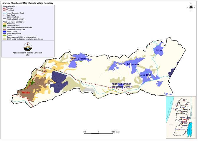
Shiha Al Kiswani family who all took refuge in 'Anata village following the 1948 war when Israel destroyed hundreds of Palestinian localities and expelled their residents. Those families came to the village and were given land by local people and are now considered landowners as any other native in 'Anata village. See Map 1 of Land Cover-Land Use inside 'Anata village

1: Land use/ land cover map of 'Anata village boundary
Israeli colonization
'Anata has been a target of the Israeli colonization due to its strategic location between Jerusalem and the Jordan Valley. Israeli Prime Minister Isaac Rabin once said that Israel would never give up on Beir Al Aghwar (The Jordan Valley), 'Anata and Joseph's tomb. Figure 1 demonstrates the land use classification of 'Anata village boundary. The figure shows that most of the area inside 'Anata village boundary is Open spaces (21026 dunums), Shrub and/or herbaceous vegetation associations (3424 dunums).
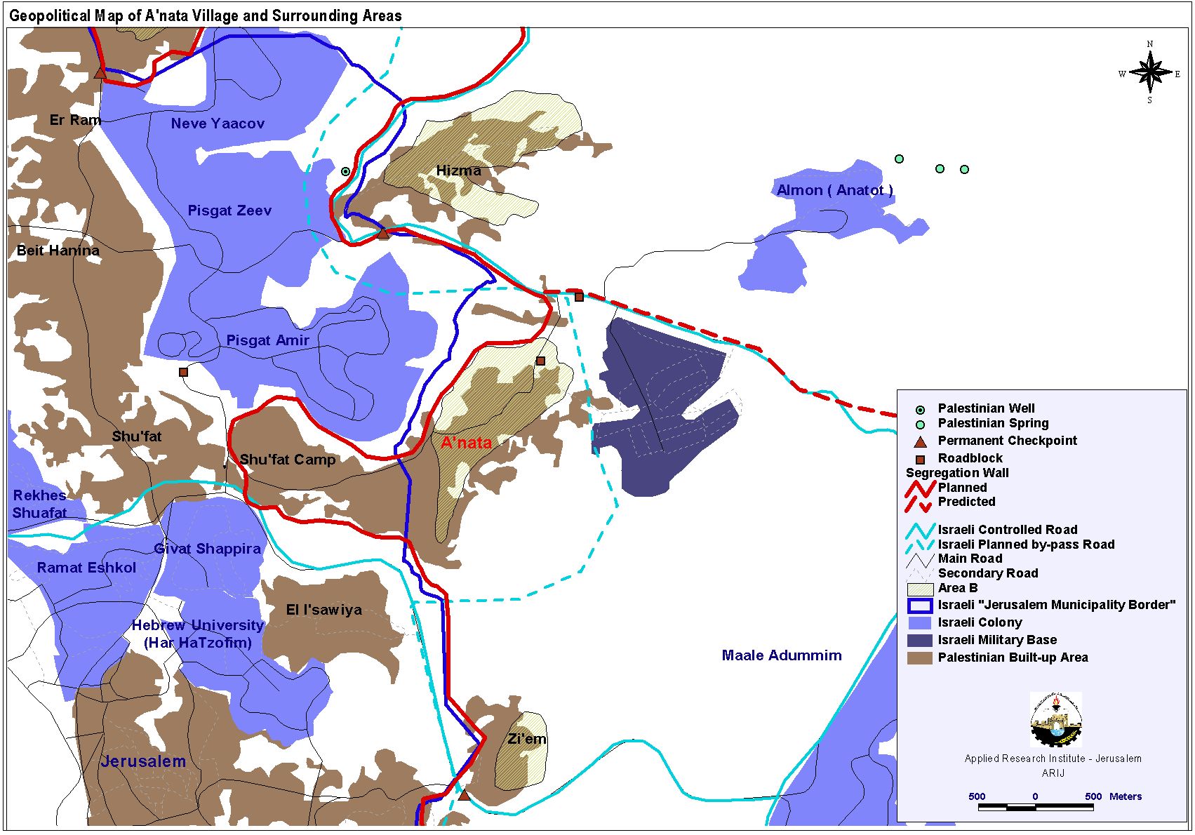
The open spaces surrounding the village opened Israels' eyes to the lands for colonization plans to illegally enlarge the boundaries of Jerusalem and to reinforce the Israeli presence in the Jordan Valley. 'Anata lands were expropriated for building four Israeli settlements and two military bases under security claims and military reasons. see Map 2. The settlements are . The settlements are
1. Almon (Northeast of 'Anata village),
2. Kfar Adummin( Northeast of 'Anata village)
3. Allon (Northest of 'Anata village)
4. Neveh Brat (East of 'Anata village).
In addition, several settlements are located to the village boundary in the southwestern and northwestern peripheries. See Map 2 Geopolitical map of 'Anata village
The settlement area inside the village boundary expanded dramatically where the settlement area settlement rose from 1069 dunums in 2001 to 6044 dunums in 2003. The Israeli government considers the expansion of the Israeli settlements as ''natural expansion''. One military base extends into the eastern part of 'Anata village boundary and the other is located directly close to the village itself. The military bases covered a total area of 1305 dunums in year 2001.
In addition to the four Israeli settlements and the two military bases, there are several Israeli bypass roads that penetrate the village boundary.
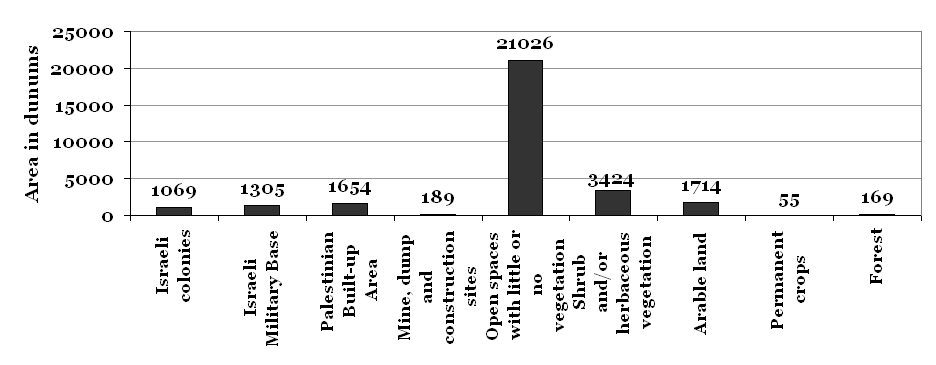
Figure1: Land cover/ land use inside 'Anata village boundary in year 2001
1. Road number 45, was built according to the Israeli plan number 910/1 and 910/2 and extends from Hitzma in the north to reach road number 1 near Mishr Adumim southeast, the industrial center of Maale Adumim.
2. Road number 70, is under construction according to the Israeli plan number 976, and is part of the Jerusalem envelope
These bypass roads enclose the eastern part of Jerusalem from its entire northern and eastern, and people are cut off from their agricultural lands. 'Anata village council objected on both bypass road, but the objections were refused by the Israeli authorities. Even though the Palestinians objected the Israeli military orders that stated the confiscation of their lands or the demolition of their houses for whatever reason given by the Israeli army, they knew that it would do them no good as the Israeli Supreme Court will only act for the welfare of the state of Israel and the Israeli colonists.
Agriculture and forest areas and water
The forest area inside 'Anata village was calculated to be 169 dunums in year 2001 and the total agricultural area was 1769 dunums, out of which 1714 was arable land and only 55 dunums were used for permanent crops. The village council leader revealed that the agricultural life is completely diminished because the Israelis prohibited people from using their land. The green land was expropriated for building the aforementioned Israeli settlements, and most of the arable lands located close to the eastern and southeastern part of 'Anata built-up area are located in area C.
Outside 'Anata village boundary, there are also a lot of springs, see Map 2. The springs were used by the people of Jerusalem, Ramallah, Beit Hanina, and the nearby refugee camps. After 1967, the Israeli forces expropriated the lands along with the springs for building Almon settlement and local people were deprived from accessing those water springs The area of the springs was also a tourist area. Now it is under full Israeli control and the lands were rented to an Israeli person who transformed it to a resort where people pay 18 NIS to enter.
Political administration
For long time before 1996, 'Anata was governed by a Mokhtar. The village council was established in 1996 soon after the inauguration of the Palestinian National Authority (PNA) on July 5,1994. The village council is administered by the Ministry of local administration and belongs to Abu Dis and Al Izariyah districts. There is no allocated budget for the council, and their expenses are covered from fees collected from formalities. Every village in the area has its own village council, but 'Anata village has no coordination with the neighboring villages due to the movement restrictions imposed on it and the bypass roads penetrating it and separating it from the other villages.
Areas B and C:-
According to Oslo Accords' classifications in 1993, 'Anata was divided into areas B and C.
Area B: The Palestinian National Authority has full civil control over the area but shares security responsibilities with Israel
Area C: Areas under full Israeli Control. Map 2 shows area B and the rest of the area is considered as area C.
People in area C are not able to construct houses because it is almost impossible to get a building license from the Israeli Authorities. Area C constitutes almost 97% of 'Anata's lands according to the village council leader. Since none of the areas in 'Anata are classified as area A, the PNA authorities can not be present on the ground; however, the PNA is responsible for the civil services in area B and helps the village council to get international funding for different projects. The division of 'Anata village to different administrative areas means that there is no plan for the whole village, and some residents complained about the lack of management in their community.
The master plan of 'Anata village 1988 included part of the buildings constructed outside the boundaries of the previous Master plan.. This Master plan was last updated by the Israeli Authorities of Beit Eil in 1992 and it served for 7 years. Local people were not informed of the update of the Master plan and it was given to them along with land divisions of areas B and C. The Master plan did not meet the needs of the local people mainly because the future urban expansion of Palestinian areas was not taken into consideration.
Israeli ''Jerusalem municipality'' :-
Soon after the 1967 war, Israel illegally expanded the borders of ''Jerusalem municipality'' to 71 km2 on the expense of Palestinian land from Ramallah and Bethlehem districts. Dahyet Al Salam, a residential area with a population of approximately 12 500 (village council leader) is built on the western part of the village. This area is enclosed within the Israeli ''Jerusalem Municipality borders''. Palestinians living in the area annexed by Israel were classified as permanent residents of Jerusalem, while those who were not recorded that time due to their absence had to apply for family reunification to the Ministry of Interior (PASSIA). Palestinian Jerusalemites are not considered as Israeli citizens, but as residents and they are subjected to Israeli law, police and courts. Due to the demographic trends which show that the Palestinian population rate increases much higher than the Israeli population (3.2% compared to 1.3% in 2001 according to PASSIA), the Israeli government has presented plans to enlarge the ''Jerusalem municipality borders''. In 1998 the concept of ''Greater Jerusalem'' was introduced, and intended to enfold settlements situated around Jerusalem into ''Jerusalem municipality borders''.
The Israeli policy of excluding Palestinians from Jerusalem city by making their life difficult has been called ''The quit transfer'' or ''The quiet deportation''. According to the Israeli Information Center for Human Rights in the Occupied Territories (B'tselem) and The Israeli Committee against House Demolitions (ICAHD), Israel's policy in East Jerusalem works as follows:
No urban planning- No building permits – Housing shortage – Construction of houses without permits – Demolition of houses – Palestinian Jerusalemites move out – Their residency is revoked.
Villagers of 'Anata were deprived from entering Dahyet Al Salam because it was included within the borders of Jerusalem municipality. Even those who got married to people living in Dahyat Al Salam. Two interviewees from Dahyet Al Salam revealed that they had been married for 5 and 7 years with men who have Jerusalem IDs. They applied many times to get a the ID same as their husbands to be able to live legally in their hometown and visit their husbands' families. However, one of them was rejected by the Ministry of Interior and the other one got no answer at all. When Israeli soldiers erect moving checkpoint between 'Anata and Dahyet Al Salam neighborhoods, these two women can not travel between their houses in Dahyet Al Salam and their work places in 'Anata. The strategy of rejecting applications for getting Jerusalem ID cards even for reasons related to family reunification is another step of ''the quit transfer-strategy''.
Many houses in 'Anata were demolished by the Israeli occupation forces during the past years. The most recent houses where demolished in May and June 2004 under the pretext of not having ''building permits''. However, building permits are not given in these areas due to the Israeli policy of limiting the Palestinian natural growth and most residents build their houses without licenses.

Photo 1: The demolished house of Abu Ahmad Al Hadad .
Israeli soldiers and jeeps prevented people from reaching the house to salvage their properties. Three years ago, the building that appears in the back of the picture was also demolished under the same pretext.

Photo 2: The demolished house of Arafat Handan
The area around the house was once very fertile, but it is now deserted because nobody was allowed to take care of the land. There is a military base nearby and the land has been razed due to the construction of the Segregation Wall. Several Bedouin families who are still living there (shown in the back of the picture) were given military orders to evacuate.
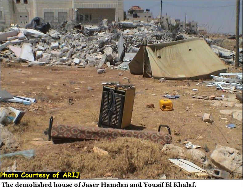
Photo 3: The demolished house of Jaser Handan and Jusef El Khalaf
The house is located close to an area where the Segregation Wall is expected to be constructed in Wadi Salim. Another two houses in the vicinity are threatened to be demolished.
Another 2-story house was demolished on the 30th of June 2004 by the Israeli bulldozers in Dahyet Al Salam and belongs to Ali Al Shakhsheer. The house was also demolished under the same pretext ''Building without permits''.
Economic indicators
The village of 'Anata has two main development sectors, economical, and agricultural in addition to quarry industry. People of 'Anata depended mainly on fruitful trees and field crops, but as mentioned earlier they were deprived from using their lands following the 1967 war. The village had several quarries and according to the village council leader many buildings in Jerusalem were built of stones from 'Anata. In addition, 'Anata's marbles reached Amman, Kuwait, and Saudi Arabia. The Israelis prevented the villagers from working in quarry industry because they expropriated most of these quarries.
Most 'Anata residents are currently unemployed and the rest work as workers in nearby Palestinian cities. Only a few of its residents are given permits to work inside Israel. One interviewee who possessed a Palestinian ID and used to work in Jerusalem turned to work in Ar Ram due to the Israeli restrictions on Palestinian movement. He revealed that he is subjected to the daily Israeli harassments. Many times, the Israeli soldiers stopped him at the checkpoint for hours and prevented him from returning to his home town.
Social indicators:-
1- Impact on Health
There are no health facilities in 'Anata except for a small clinic that has one nurse and one doctor who comes once a week and only for few hours. The village also lack ambulance cars. There is only one clinic in Dahyet al Salam, where one has to pay the expenses of his/her medical treatment if he/she doesn't possess a Jerusalem ID.. The nearest medical centers are in Jerusalem and most of the villagers are forbidden to enter, and in Ramallah, which takes long travel time to reach due delays caused by the Israeli soldiers at Qalandyia checkpoint. One citizen said that the Israeli soldiers guarding the checkpoint didn't let him cross the checkpoint on his way back home from the hospital in Ramallah with his son who suffered from pain in the leg. He finally managed to cross the checkpoint but had to carry his son a two kilometers distance. Many people have died because they could not reach the hospitals at the right time.
There are four pharmacies in 'Anata owned by local residents, 3 in 'Anata and 1 in Dahyet Al Salam. Villagers get their vaccinations from the Palestinian Ministry of Health where a doctor comes to the only clinic in the village and gives vaccinates to the children.
2-Impact on Education:-
According to PCBS 1999, 6 % of 'Anata residents were illiterate. The village has three governmental schools which house 1820 students and 85 teachers, one high school for boys, other high school for girls and another co-educated secondary school. The secondary school is overcrowded with students and it does not comply with the needs of the village according to the village council leader.
In addition, there are some private schools in 'Anata, that house 2005 students and 112 teachers:
-
Shireen School in Dahyet Al Salam-co-educated (from the first grade to the 8th grade). They intend to extend the classes to the 12th grade.
-
The American Al Mawakeb elementary school
-
Beit Al Magdis -co-educated secondary school in 'Anata.
-
Al Iman School and Nursery -elementary school.
One of the schools in the village is separated from its playground by the Israeli authorities as it was included to ''Jerusalem municipality borders''. Normally, students would go there, but their existence on the playground is illegal. See Table 1
|
Table 1: Number of students and teachers in 'Anata |
||||
|
|
Students |
Students out of 'Anata |
Teachers |
Teachers out of 'Anata |
|
Public schools |
1820 |
60 |
85 |
40 |
|
Private schools |
2005 |
615 |
112 |
67 |
|
Total |
3825 |
675 |
197 |
107 |
|
Source: 'Anata Local Council |
||||
Many people in the village, (almost 7.4% of the total population, according to PCBS 1999 statistics) carry high educational degrees and from both sexes. Meanwhile, students nowadays have difficulties going to universities outside the village due to the many checkpoints that exist on roads leading to Universities which hindered the educational process in the village. Villagers of 'Anata believe that the anticipated construction of the Segregation Wall would further restrict villagers movement as there will be only one passage for entry and exit to be used in addition to the restrictions imposed on them by the existence of the checkpoints.
3- Security aspects:-
Nowadays, crime is accelerating in 'Anata area because of the terrible living conditions and due to the absence of Palestinian Police. Most people in the village live under poverty line. Villagers reported that there has been many robberies in the area, break troughs, stealing of cars and even murder. Also drugs are used more often these days by youth.
General social services:-
There are no recreational centers in the Palestinian community of 'Anata, except for one small youth club. The village also lack Institutions or organizations that provide services for males and females,; playgrounds, libraries and rehabilitation centers although there are 360 handicapped people in the village according to 'Anata village council leader. Most of them are handicapped due to injuries they got during the Intifada. These people are banned from reaching any center in the West Bank or Jerusalem due to the restrictions imposed on them.
The students of the village have established a public library situated in the local club. This library serves students of ages between 6 and 14 years. Some girls felt the need for public library inside their village since they did not have one in their school. They got help from three organizations, Panorama, Maan, and UNICEF.. In addition, the local club offers activities related to culture, sport , art and summer camps.
There are two high voltage electricity networks running across the village lands, the first is running from the main electricity company and serves people of 'Anata and the areas around to Jericho while the second one is an international high voltage line (32 000 volt) that serves the Israeli settlements. These lines made people feel uncomfortable because they took parts of their lands and puts the lives of many in danger.
A water pipe and two sewage lines serve the Israeli settlements pass through the village lands from the northern and southern peripheries depriving people of 'Anata from using their lands. The village gets water from the Israeli Micorot company and their sewage network is connected to the nearby sewage lines serving the settlements. Residents did not complain about the supply of water, but they felt it was not clean. One woman living in Dahyet al Salam, where Israel has full control of the area said that her children got Ameba from the water they drink.
'Anata village has a bus company owned by people of the village owned. The company was established in 1962 with a Jordanian authorization. Now the bus company is not allowed to function and transportation means to and from the village became insufficient. People have to take transportations from Shu'fat camp to reach 'Anata.
A few projects were executed by the village council with the help of donors' from foreign countries, such as rehabilitating schools, paving roads and lighting streets. Extension to the secondary school for the boys was funded by 50% from PECDAR and the other 50% from the local residents. Now they have an allocation of 100 000 US $ from the municipality budget to pave the streets. The village council also intends to rehabilitate the water network since the original water and sewage network were done on the expense of local residents. With the help of the European Union, the council was able to buy a new garbage collection car which collects garbage at regular basis.
The Segregation Wall:-
Due to the high population density in Shu'fat Camp, Ras Khamis, 'Anata and Hizma, these villages were planned to be situated at the eastern side of the wall.
Palestinians from 'Anata received military orders in march 2004 stating the confiscation of the village's lands to build the wall. A local committee headed by engineer Hussein Al Rifai was formed. The lawyer Mohammed Dahla was hired by the PNA to object the orders of confiscation. Another committee was also formed in Dahyet Al Salam and Ras Khamis and another lawyer was hired to handle the case due to the fact that residents of Dahyet Al Salam and Ras Khamis carry Jerusalem IDs. People who carry Jerusalem IDs are severely affected by the Segregation Wall since their life and work are connected to Jerusalem from which they will be separated., The IO bulldozers started bulldozing Lands in.. preparing for the construction of the Israeli Segregation Wall.
On the 27th of June 2004 the construction started. Together with the predicted bypass road that is to be built at the eastern peripheries of 'Anata, the Segregation Wall will isolate 'Anata, Dahyet al Salam and Shu'fat camp, see map 2. .
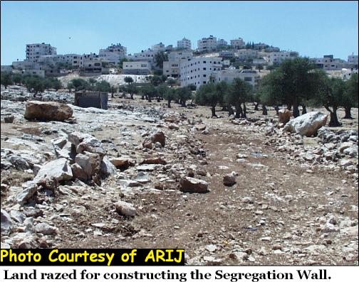
Photo 4: Land razed for constructing the Segregation Wall.
This area is located near the demolished house of Arafat Hamdan and the houses of the Bedouin families who were given military orders to evacuate their houses, see Photo 2. In total. 300 Bedouin families are threatened to evacuate their land which are 200 meters away from 'Anata.
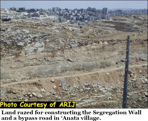
Photo 5: Land razed for constructing the Segregation Wall/ bypass road?
To the left, is the photo the military base near 'Anata village. In the front, a high voltage electricity line is present

Photo 6: Land razed for constructing the Segregation wall.
In the front appears the, demolished house of Mohammed Musa Jabuuaa. The house was demolished in the beginning of June 2004 under the pretext of building without permit.
Effects of the wall
The wall will have a negative impact on residents of 'Anata, also on people living close to the village and consider 'Anata as the only commercial in the area. It would be even more difficult to reach medical centers situated in Ramallah. Students would have more problems to reach universities, school students and teachers from outside 'Anata would face difficulties in reaching their schools inside the village. It would also be difficult for those who work inside Israel to reach their workplaces, and those who work in 'Anata but live in the neighboring villages to reach their workplaces.
The wall will strongly affect the educational life in 'Anata since 107 of the school teachers in addition to 675 children who attend schools in 'Anata come from the neighboring villages, see Table 1. In addition, students from 'Anata go to schools located outside the village.
One student who studies at Al Quds University, Abu Dis said that the wall would mostly affect her education, and thereby her overall future. She noted that this problem will be faced by most youth of her age who attend universities outside the village, especially the girls as people are reluctant to send their girls outside the village to get higher education when the overall security conditions are bad. It takes her now 45 – 55 minutes to reach her university. On her way to University, she has to pass a checkpoint near the settlement Maale Adumim which does not open before 9, as a result, she has to reschedule her classes after 9.30. It would take her 1.5 to 2 hours to reach the university if the Segregation Wall is to be constructed in the area.
One female citizen was concerned about the impact of the Segregation Wall on family relations. She didn't see her family in Nablus for 2 years. She thought that the wall would totally close the village and prevent visitors from entering.
One male citizen noted that the wall would also have devastating effects on the village's economic and psychological sides.. People would become separated from their lands and families.. He revealed that the village is already suffering and this would get even worse.
The village council leader mentioned that there is only one dumping area in Al 'Izariyeh where people of 'Anata dump their garbage. If the garbage cars are prevented from accessing the place, there will be a health disaster in 'Anata as there would be no other place to dump their garbage. In addition, he expects that the construction of the wall would lead to immigration. People who carry Jerusalem IDs already moved out to live in Jerusalem because of the Israeli Ministry of interior regulations. Those who moved wanted to keep their IDs and maintain their jobs inside Jerusalem. The village council leader expects that more people will immigrate to the neighboring Arab countries.
Most Residents interviewed in 'Anata had negative future visions: There is continuous expansion of Israeli settlements, and agricultural areas are becoming rare. The village will be totally surrounded by the wall and bypass roads. The economic level would chop in addition, the living conditions people live will become even worse. Job opportunities would become rare; thus increasing the unemployment rate.. In sum, the conditions of 'Anata and its residents are deteriorating every day.
Prepared by:
The Applied Research Institute – Jerusalem


