Rantis, is a small Palestinian village located to the northwest of Ramallah district in the Palestinian West Bank. It has a total population of 2688 inhabitants and a built up area of 458 dunums (115 Acres). The village is inhabited mostly by 6 clans (Wahdan, Hallaf, Ballot, Dar Abo Salim, Al Yahee, Hawashe. Most of Rantis villagers depend on agriculture as their main source of income. A small number of social infrastructure facilities exist in Rantis. Table one summarizes the existing facilities in Rantis village:
Table 1:- Facilities exist in in Rantis village
|
B_ Rantis school (students 650) |
A_ Rantis Female Elemintary School(students 400) |
1-Schools |
|
B-Children club kinder Garden ( 25 children) |
A-Rantis Kinder Garden (60 children ) |
2-Kinder Garden |
|
|
There are 120 students in Beir zate, Jerusalem, Al Najah universities. |
3-University |
|
|
One |
4-Clubs |
|
B-AlZawaya Afeff Mosque |
A-Omar Ben AlHatab |
5-Mosque |
|
|
Three Clinics |
6-Clinics |
|
|
One highway street in the village |
7- Highway street |
|
|
One |
8-Bus station |
Israeli activities in the village:-
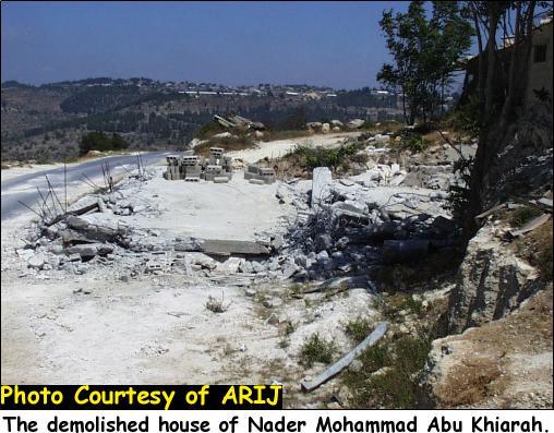
In 1967 the Israeli forces confiscated most of the Palestinian agricultural lands in the village for colonizing purposes, and hundreds of olive trees were uprooted. Today, the village of Rantis is surrounded by a set of settlements and Israeli military areas, such as Ofrim and Beit Arye settlements which are located to the east of the village in addition to a military area located to the northwest of the villageRecently, the village lands became threatened by Israeli land confiscation activities for constructing the Segregation Wall, see map bellow..
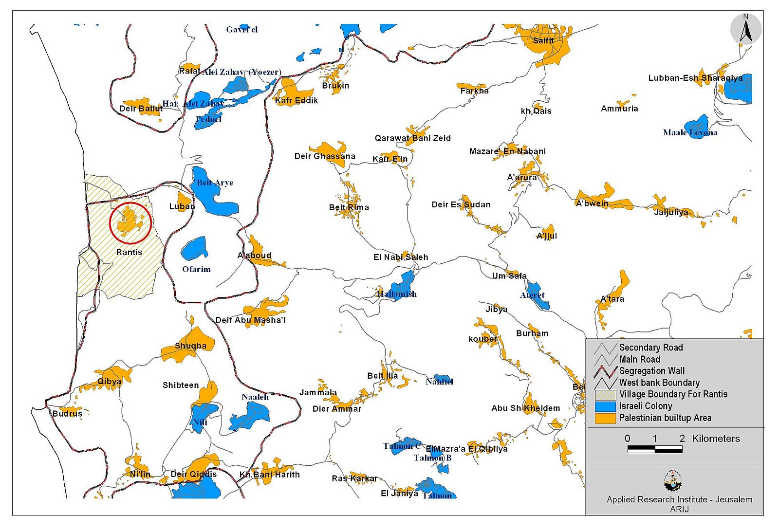
In November 2003, The Israeli occupation forces handed Rantis villagers military order number (03/ 69/T Judea & Samaria 2003) stating the confiscation of 862 dunums of their agricultural land for the construction of the Segregation Wall. In Reality, this military order means the actual confiscation of about 3000 dunums of the village lands. see a copy of the military order.
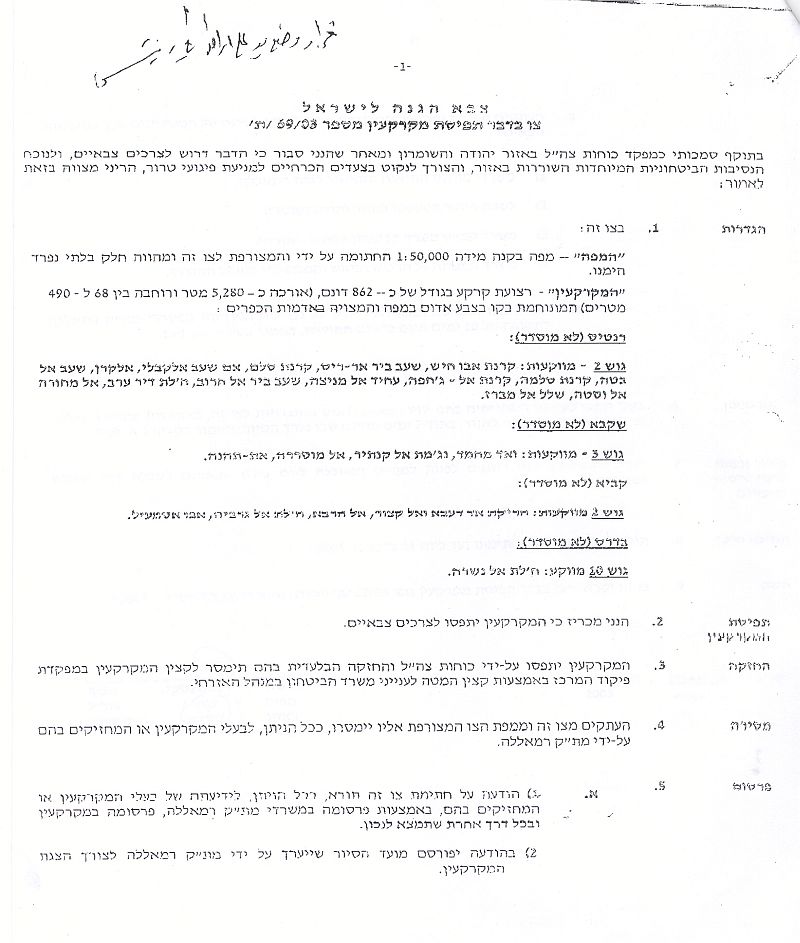
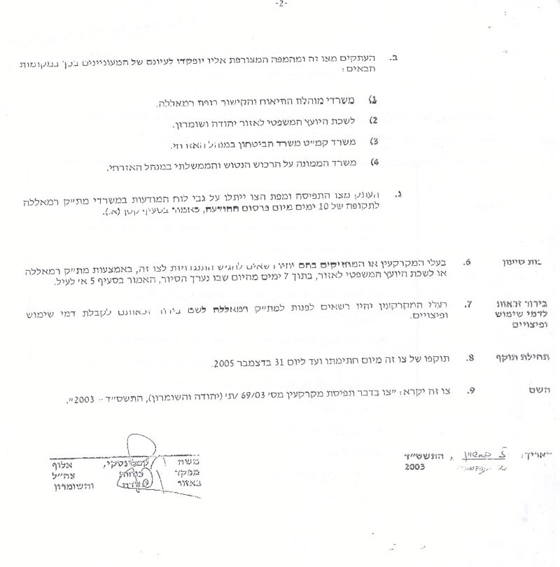
Israel Defense Forces
Order to Seize lands n0 03/69/T
According to my authorities as a Military Chief Commander in the Region of Judea and Samaria, and as I believe that it is imperative for military reasons due to the special security situation in the region, I order the following:
1. The ''Map'' signed in scale 1: 50000 and attached to the order is an essential part of this order. The ''Lands'' : An area of land which is 862 dunums (5280 meter long and 68_490meters wide) marked in red in the map :
· Block 2: In Karnt Abo Hesh ,Sahhab Bear Rees , Krnet Selm ,Am Shhab Al Kably , Alkarn , Shob Albta , Karnet Salma , Karnet Al Jahfa , Aheed Almnsa, Shod ber Alhroob , Halat Dear Arab , Almahora Alwasta, Shallal Almbraz
2. I announce by that the above mentioned lands are seized for military reasons
3. The IDF seize the lands and have an absolute control over it that is given to the officer of the central command officer of lands who is responsible in the ministry of defense.
4. These copies are to be given by the District Co-ordination Office ''The DCO'' of Ramallah to the owners of land.
5. Copies are found with maps for those who are interested in the following places
· DCO of Ramallah.
· Offices of the Juridical advisor in the region
· The office of commander responsible in the ministry of defense in the civil administration.
· Office responsible of absentee and public lands in the civil administration.
6. The owners of land have the right to go to the DCO in Ramallah in order to get more information about their right of land use expenses and compensation.
7. The Validity of this order starts at the date signed till 31/12/2005
8. The name of this order is: '' Order to seize lands n0 03/69/T (Judea & Samaria ) 2003
Mosheh Kaplenski
Chief Commander of The Israel Defense Forces in Judea & Samaria
9/2/2003 -Signature
The impact of the Segregation Wall on Rantis village:-
Agricultural Effects:
The village according to the recent Israeli military orders and the map published on the Israeli Ministry of Defence will surround the city by two types of wall, the first is the Western wall (Main wall). The second is an eastern wall ( secondary or depth wall). The construction of the main Wall led to the confiscation of one artesian well that became surrounded by barbed wires from all directions and no Palestinian is allowed to approach it. As a result, vegetables and crops were disposed because water shortage and unavailability for irrigation. The Wall also increased the difficulty of transporting good and products to the markets.
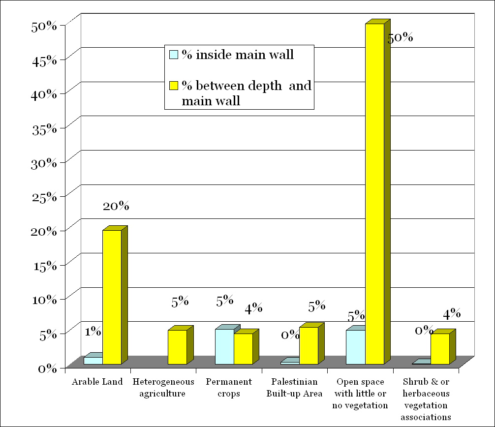
Most of Rantis farmers depend totally on agricultural production as their main source of their income. Farmers are now hindered from accessing their agricultural lands and therefore will have to search for alternative ways to earn a living. This in return increases the unemployment rate and poverty level. Table (1:a) shows the total numbers of dunums isolated behind the Segregation Wall and the land isolated by the depth Wall (between the secondary wall and the main walls shown in the previous map). See Table 2 a, 2b & 2c
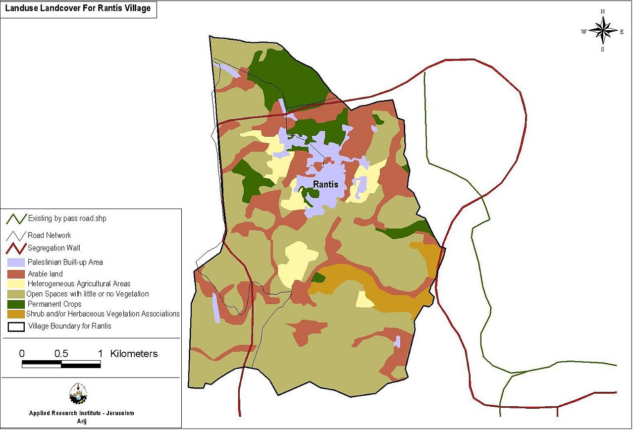
Table (2:a) Agricultural lands in Rantis village (Dunums):
|
Land Type |
Dunums |
Percent |
|
Arable |
2148 |
21% |
|
Heterogeneous Agricultural Areas |
520 |
5% |
|
Permanent Crop |
1000 |
10% |
|
Palestinian Built-Up Area |
598 |
6% |
|
Open space with little or no vegetation |
5710 |
55% |
|
Shrub & or herbaceous vegetation associations |
472 |
5% |
Table (2:b) Agricultural lands between depth wall and main wall (Dunums) :
|
Land type |
Dunums |
Percent |
|
Arable |
2041 |
20% |
|
Heterogeneous Agricultural Areas |
520 |
5% |
|
Permanent Crop |
469 |
4% |
|
Palestinian Built-Up Area |
566 |
5% |
|
Open space with little or no vegetation |
5193 |
50% |
|
Shrub & or herbaceous vegetation associations |
464 |
4% |
Table (2:c) Agricultural lands inside the main wall (Dunums )
|
Land type |
Dunums |
Percent |
|
Arable |
107 |
1% |
|
Heterogeneous Agricultural Areas |
Not available |
Not available |
|
Permanent Crop |
531 |
5% |
|
Palestinian Built-Up Area |
32 |
0% |
|
Open space with little or no vegetation |
517 |
|
|
Shrub & or herbaceous vegetation associations |
8 |
0% |
Chart 1: A comparison between the agricultural land behind the main wall and between the main and depth walls: : A comparison between the agricultural land behind the main wall and between the main and depth walls:
.Educational Effects:
Teachers in Rantis village became unable to reach their schools due to the village isolation caused by the Wall, and schools are only opened few days a weak. Students are facing daily humiliations committed by the Israeli soldiers guarding the military gate. Such measures have caused daily delays for both students and teachers who find themselves forced to wait in rows and for a long period of time.
Health Effects:
The villages' clinics are closed and the medical crews cannot reach them. They need to coordinate first with the relevant Israeli authorities before being allowed to enter the village. This in turn opposes their work in the village and blocks the process of supplying the village with medical services.
Conclusion:
The Wall anchors Israeli military occupation and settlement existence in the Palestinian territories, in a blatant violation of international law and resolutions, which do not permit annexation of land by force.The Government of Israel continued to follow a policy that aimed at annexing more Palestinian lands and violating its obligations under the Fourth Geneva Convention and UN resolution 446 (1979) related to settlements in the Arab territories occupied since 1967, including Jerusalem.
The resolution determines that ' all measures taken by Israel to change the physical character, demographic composition, institutional structure or status of the Palestinian and other Arab territories occupied since 1967, including Jerusalem, or any part thereof, have no legal validity. Therefore, Israel's policy and practices of settling parts of its population and new immigrants in those territories constitute a flagrant violation of the Fourth Geneva Convention relative to the Protection of Civilian Persons in Time of War, and also constitute a serious obstruction to achieve a comprehensive, just and lasting peace in the Middle East Region?'.
-
The wall restores the Ghetto culture and instills an apartheid regime encouraging discrimination in the era of globalization, openness and integrated markets.
The wall drives towards the practice of ethnic cleansing and is subjecting an entire population to aggressive collective punishment, to the strangest and harshest laws such as separating the farmers, students,workers and the sick from their lands, water sources, schools, doctors and hospitals from their workplaces. This violating all international lows and Geneva Convention in particular Article 33'No protected person may be punished for an offence he or she has not personally committed. Collective penalties and likewise all measures of intimidation or of terrorism are prohibited .pillage is prohibited .Reprisals against protected persons and their property are prohibited Moreover, it divides each city and village into enclaves, splitting and dispersing members of the same family. These practices contradict basic human rights, the 4th Geneva Convention and the related international covenants.
-
The wall destroys hopes for peace and political initiatives; it also jeopardizes security and stability in the Middle East.
Under Article 12 of Annex I, Low 14 in the Israeli -Palestinian interim Agreement in the West Bank and the Gaza Strip book:' Israel and the Palestinian side shall cooperate in implementing principles and standards, which shall conform with internationally accepted principles and standard ,concerning the protection of endangered species and of wild fauna and flora, including restriction of trade, conservation of migratory species of wildlife and preservation of existing forests and nature reserves. So all the Israeli policy of land confiscation is against all international lows and resolutions and a clear violation of Human Rights .
Prepared by:
The Applied Research Institute – Jerusalem