During the past three and a half years, Israel has constructed more than 750 barriers in the West Bank dividing it into small cantons. All main and secondary roads connecting Palestinian districts were blocked either by cement blocks or by barbed wires which forced Palestinians to take alternative roads that are ''time consuming'', narrow and dangerous. Palestinians daily movement became very difficult; whereby Palestinian citizens heading to their workplaces, schools and hospitals were not able to reach their destination easily. Humiliation, suffering and delays are encountered at the many barriers which were installed by the Israeli occupation forces (IOF) in the Palestinian Territories. The table below shows the number and type of barriers constructed in the West Bank during the period 2001-2004.
Table1: Number and Type of barriers in the West Bank during the period 2001-2004:
|
Type of barrier |
Number of barrier |
|
Military checkpoints |
73 |
|
Trenches |
58 |
|
Roadblocks |
95 |
|
Earth mounts |
464 |
|
Military Gates |
34 |
|
Iron Gates |
33 |
|
Total |
757 |
Source: ARIJ Database
The Qidron valley road OR the so called 'The Fire Valley Road':-
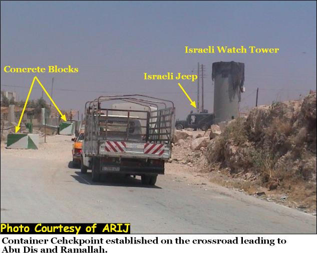
The 'Container checkpoint' is an Israeli checkpoint erected on the hill top of Qidron valley road (The Fire Valley Road) and blocks the entrance of As Sawahra Ash Sharqiya village. This checkpoint blocks the way and access in front of the Palestinians living in the southern Palestinians governorates (Bethlehem and Hebron) to the rest of the West Bank and vice versa. Before the second Intifada which erupted in late September 2000, the Israeli soldiers occasionally used to place a temporary checkpoint at the junction of As Sawahra As Sharqiya, check Palestinian IDs and then leave. This spot turned to become a permanent checkpoint constructed by the Israeli soldiers following the second Intifada to block the crossroad leading to As Sawahra Ash Sharqiya, Abu Dis, Ramallah and the northern Palestinian Governorates to make the daily life of thousands of Palestinians unbearable. Today, Palestinians must have travel permits in order to travel inside the West Bank issued by the Israeli authorities to be able to cross it.
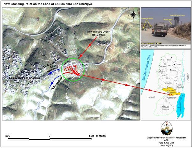
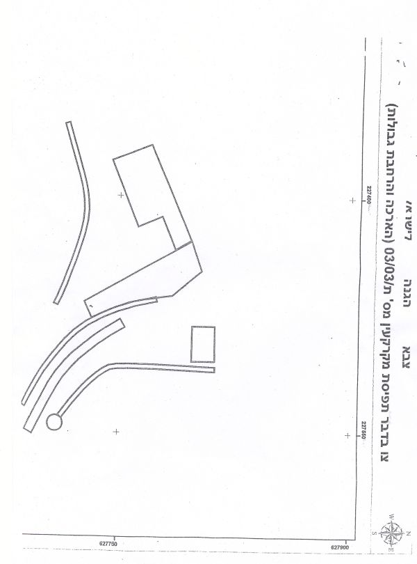
On June 14th 2004, the Israeli chief commander Mosheh Kaplenski issued a military order to confiscate 4.85 dunums of lands from As Sawahra Ash Sharqiya and Abu Dis cities to construct a new crossing point at the location of Al Container checkpoint. The importance of this checkpoint is that it is the only link that connects north of the West Bank with its south. Lands threatened belong to the residents: Khalid El Sarfi and 'Abed Allah Jamel. See Map of military order, normal and zoomed and

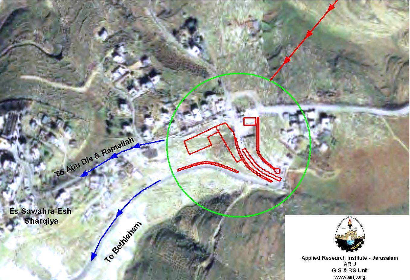
The military order issued will hinder the mobility and freedom of movement of Palestinian citizens and will freeze their daily activities. The Israeli authorities are planning to install new cement blocks, barbed wires check up corridors and military watching towers at Al Container checkpoint to make it permanent. See copy of military order 1, 2 &3,
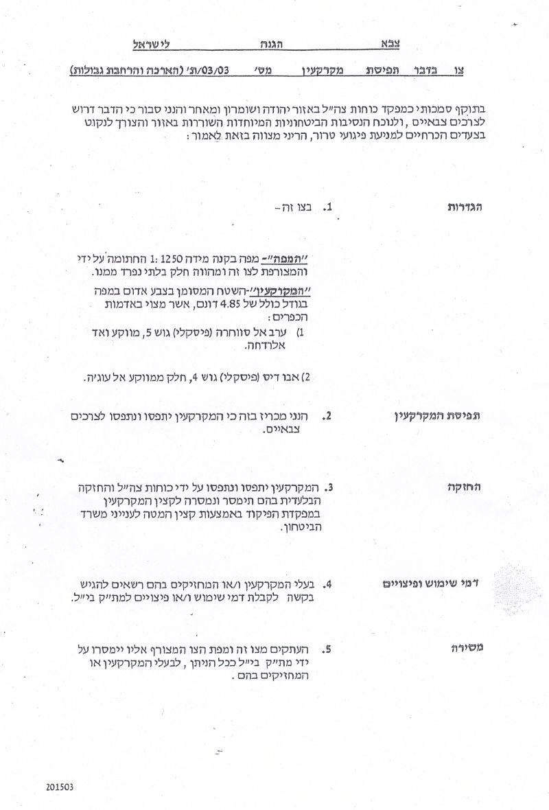
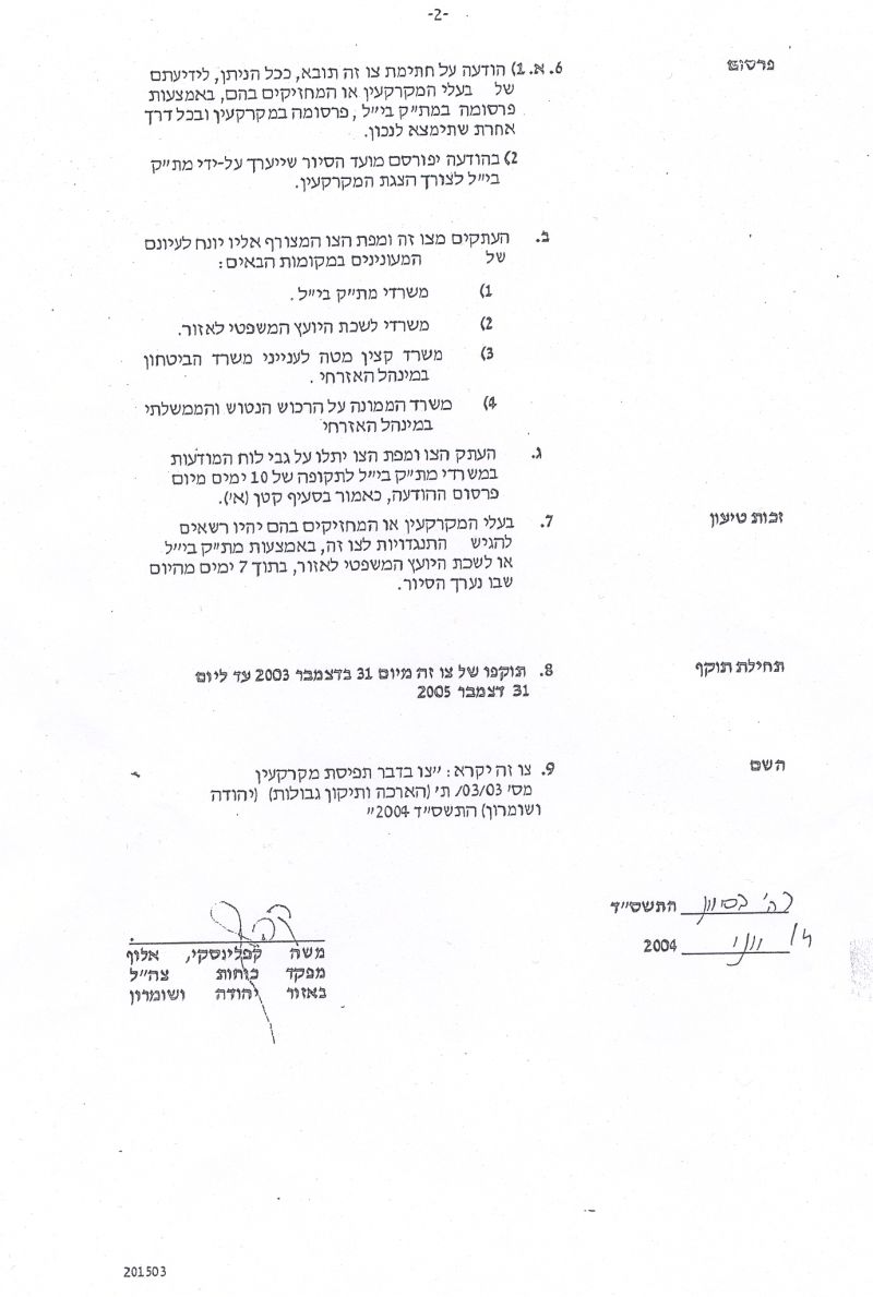
Military order number 03/03/ T Issued by Military Chief Commander Of the IOF in the West Bank: Mosheh Kaplenski
Military Order's Translation
Israel Defense Forces
Order to Seize lands n0 03/03/T
According to my authorities as a Military Chief Commander in the Region of Judea and Samaria, and as I believe that it is imperative for military reasons due to the special security situation in the region, I order the following:
1. The ''Map'' signed with a scale of 1: 1250 and attached to the order is an essential part of this order. The ''Lands'' : An area of land which is 4,850 dunums with 340m length marked in red in the map that exists in:
Arab Al Sawahira:
Block 5 in Wad El Radha area
Abu Dis:
Block 4 in El 'Awja area
2. I announce by that the above mentioned lands are seized for military reasons
3. The IDF seize the lands and have an absolute control over it that is given to the officer of the central command officer of lands who is responsible in the ministry of defense.
4. These copies are to be given by the District Co-ordination Office ''The DCO'' of Bethlehem to the owners of land.
5. Copies are found with maps for those who are interested in the following places
- DCO of Bethlehem
- Offices of the Juridical advisor in the region
- The office of commander responsible in the ministry of defense in the civil administration.
- Office responsible of absentee and public lands in the civil administration.
6. The owners of land have the right to go to the DCO in Bethlehem in order to get more information about their right of land use expenses and compensation.
7. The Validity of this order starts at the date signed from 31/ 12/ 2003 till
31/12/2005
8. The name of this order is: '' Order to seize lands n0 03/03/T (Judea & Samaria ) 2004
Mosheh Kaplenski
Chief Commander of the Israel Defense Forces in Judea & Samaria
14/06/2004 -Signature
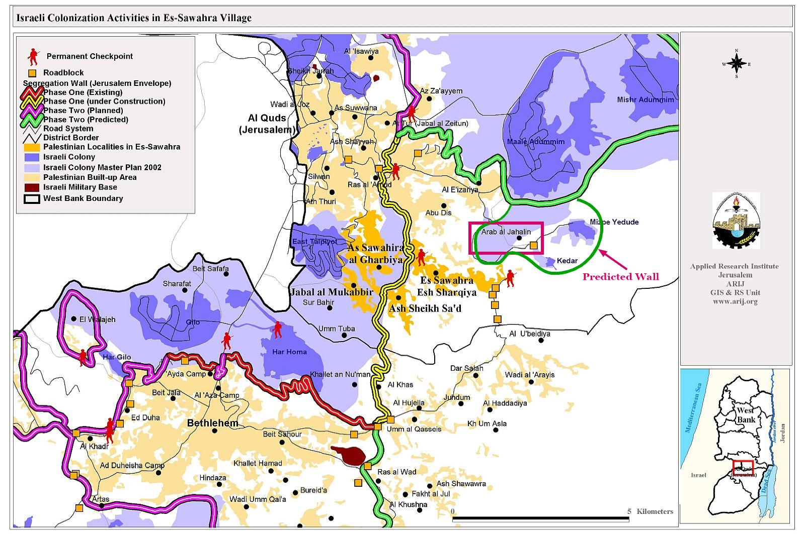
The analysis of this order using the GIS images shows that Israel aims at annexing more Palestinian lands to Israel; at the same, fragmenting any geographical continuity between the northern West Bank districts such as Salfit, Nablus, Qalqilyia, Jenin and Tulkarem and the southern ones such as Bethlehem and Hebron. The Israeli plan to erect a new and permanent crossing point on this spot is yet another fact, phrased more accurately, of the Israeli practices to control the movement of Palestinians. To the person coming from Bethlehem and Hebron heading to his destination will face extreme 'humanitarian' treatment and will have to go through excessive security checks.
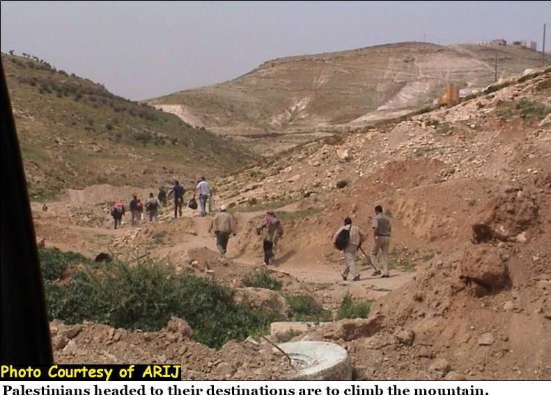
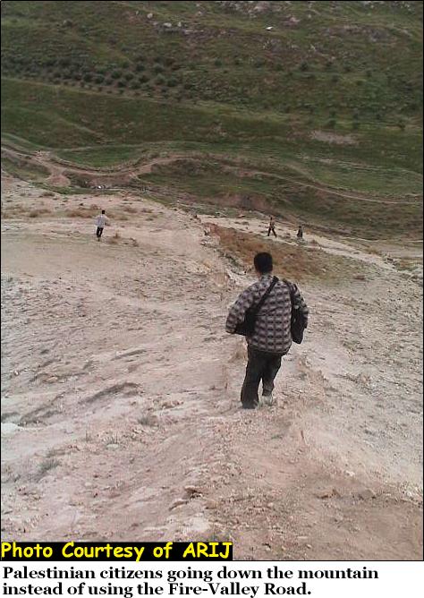
In the past three and half years, neither taxis nor civil cars were allowed to cross the checkpoint. Passengers heading to their workplaces had to get out of the car, walk along the road which is about 250-300 meters down and away from the checkpoint, to then climb a hill to reach the road on the other side of the hill, about 200 meters away from the checkpoint to escape the long delays caused by the Israeli soldiers at the checkpoint for security inspections.
Applying more restrictions on the Palestinian movement, the Israeli military authorities erected a fence of barbed wires on the hill located down the checkpoint to prevent Palestinian residents from avoiding the checkpoint. Therefore, entry to As Sawahra and Abu Dis cities was blocked and Palestinians couldn't climb the hill because of the barbed wires. Thousands of Palestinians became jobless for quite long time because there was no way they could pass the checkpoints due to the Israeli restrictions such as capturing of ID Cards and forcing Palestinians to wait for long hours under the burning sun; in addition to checking of private belongings and using of Gas bombs. Thus, crossing the checkpoint was the last choice a Palestinian worker, staff or student would think to do due to such harsh security measures exerted by the Israeli soldiers.
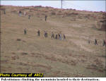
Palestinians could no longer bear such harsh measures and had to look for alternatives. The alternative was ''200-300'' meters high and dangerous hilly slope, about 1-1.5 kilometers distance which Palestinians found to sneak past the Israeli closure measures and to get their destinations. See photos of mountains. See Photo 1, Photo 2 & Photo 3,
The Israeli forces later allowed Taxi drivers to cross the checkpoint along with their cars, but prevented private ones from crossing unless they have permits. As the entrance of the checkpoint is blocked by concrete blocks which usually remain by the side of the road andstop vehicles from using the side road. Many Taxis on their way to cross the checkpoint are forced to queue a short distance away from the checkpoint (usually 10-15 meters) and wait for the Israeli soldier guarding the checkpoint that time to call them one by one to drive towards him for ''security inspections.'' Click to see photo 4 below
The latest Israeli military order which suggest the erection of a Segregation Fence on the hill down the checkpoint and a huge crossing point is resembled as Gilo 300 located at the northern entrance of Bethlehem where there will be a two sided corridor for security check, normally controlled by unreasonable preconceived decisions by the Israeli soldiers about whether a particular Palestinian may pass through or not.
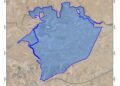
The analysis shows that a physical structure is expected to be built along the eastern areas of As Sawahra As Sharqiyia, to enfold and annex two more Israeli settlements, Kedar and Mizepi Yehude within the Segregation Wall which is currently being built on the expense of Palestinian lands. According to the analysis, a small Palestinian community called Arab Al Jahalin located to the east of As Sawahrah As Sharqiyia and houses a population of 1136, PCBS 2003, might be forced to evacuate the place as it will be isolated inside the 'projected Segregation Wall/Fence'. See map of projected Wall. click to see map below
Accepting humiliation is the only choice left for Palestinians. If Palestinians are prohibited to get across the checkpoint, their lives will crumple as people will become incapable to earn a living. Checkpoints not only threaten the need of the Palestinian society to live in peace, but also put the lives of thousands in danger. Restrictions on Palestinian movement through checkpoints in addition to the construction of the construction of the Segregation Wall are illegal actions with regard to the United Nations General Assembly resolution dated on October 21 which demands Israel to ''stop and reverse'' the construction of the Wall it is building in the Occupied territories and totally ignores the 144 nations who voted in favor of the resolution which was also supported by the European Union, the sponsor of the ''roadmap'' plan.
Prepared by:
The Applied Research Institute – Jerusalem