Israeli Prime Minister Ariel Sharon's policy of disengagement and separation is being put into effect in an ever accelerating pace. The daily changes on the ground are best exemplified by expanded confiscation orders, and construction of the wall and bypass roads taking place throughout the West Bank. Yesterday, the 20 of April 2004, as construction of the wall continues around the Bethlehem enclave, the Israeli Occupation forces (IOF) handed out new military orders seizing more land.
Bethlehem is currently surrounded by 15 km of the segregation wall with an Israeli approved plan of an additional 35 km of the wall to be constructed. See map 1
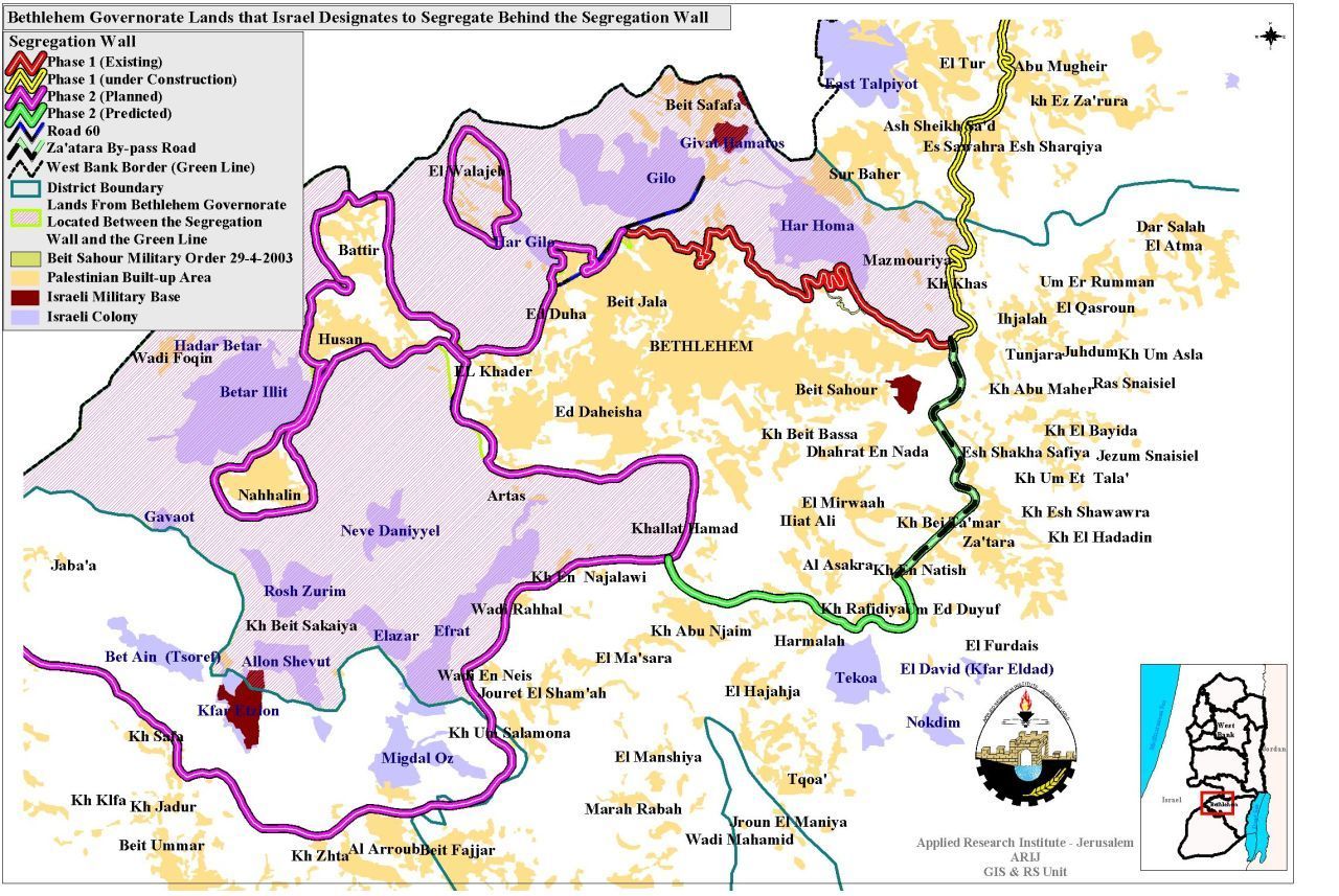
Map 1: The Israeli plan in Bethlehem Governorate
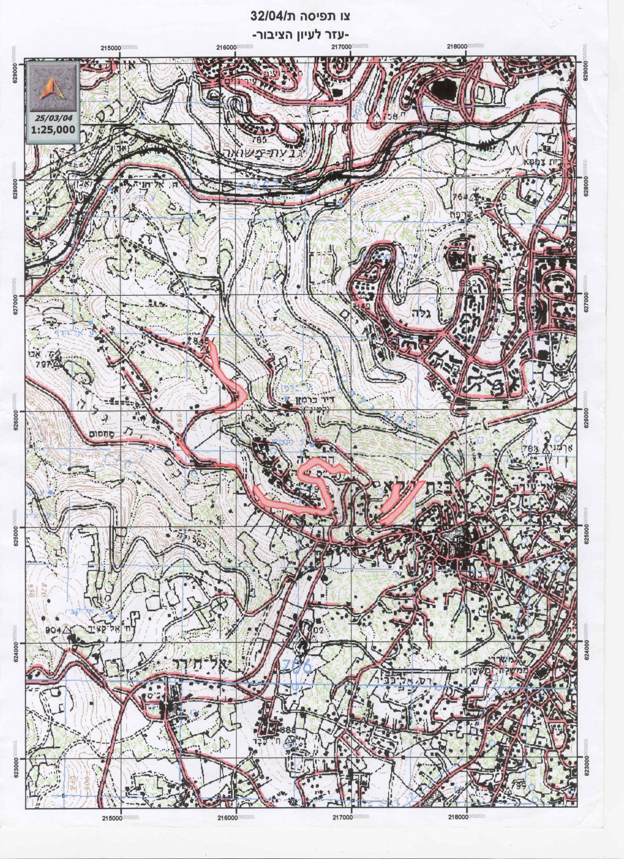
On April 19, 2004, the Israeli Occupation forces – IOF – began implementing more of their plan for the Bethlehem district by handing the residents of the town of Beit Jala land seizure orders. Military order n0 04/32/T will result in the seizure of 175.6 dunums of land from Beit Jala and Al Walaja residents upon which the Segregation Wall will be built to continue the construction of a ghetto composed of the built-up sections of Bethlehem city and its surrounding urban neighborhoods which includes Beit Jala. Among the owners, the following were known:
|
|
The following table also shows the blocks of land seized under this most recent military order:
|
Location |
Block # |
Parcel name |
|
Al Walaja |
3 |
Al Sarj , khalet Al Husein |
|
Beit Jala |
2 |
Ruweisat, Al Ras , khirbet Injar , butein Al jarbi, khalet Al 'Abass , Al habal , 'Ein Hantash |
|
3 |
Al Cremesan ( for Cremesan Monastery, Cremesan Nuns Monastery and Kindergarten) |
As shown in the map of the Israeli military order, six separate sections of the already approved overall plan of the Separation Wall are to begin construction as represented by this military land confiscation order. Part of the land seizure (two sections) will allow the Israelis to build a wall on each side what is now known as bypass Road # 60. As shown, Route 60 passes through the heart of Beit Jala lands and separates the town from its agricultural lands that extends west of Beit Jala. See map of military order
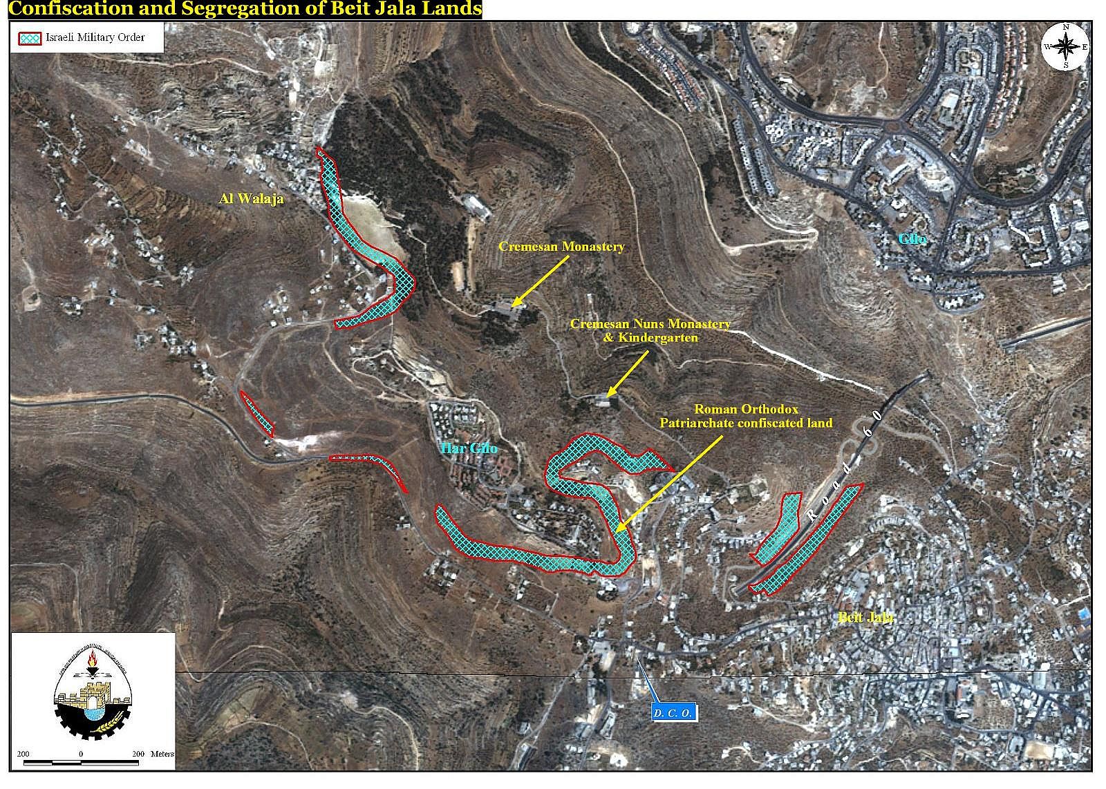
The other four (4) sections of the Separation Wall will continue the enclosure of Beit Jala and the Al Walaja village leaving the Har Gilo settlement, located in Al Ras area (top hill of Beit Jala )free for Israeli annexation. See map of military order as provided by Israelis
As envisioned by Israel, the Har Gilo settlement, together with the rest of the Gush Etzion settlements, will compose the southern boundary of Israel's planned 'Greater Jerusalem' or 'Metropolitan Jerusalem'. Israel's completion of the 'Greater Jerusalem' plan will incorporate not only Gush Etzion, which is one of the largest Israeli colonized blocks in the West Bank, but also the Ma'aleh Adumim and Giva'at Zeev Israeli settlement blocks. This unilateral incorporation of these settlement blocks is, in its essence, an illegal annexation of major portions of occupied Palestinian land as defined by the 1949 armistice line and therefore represents a serious violation of international law. Furthermore, it will explicitly separate the religious and cultural sites of Jerusalem city and its Palestinian institutions from the remaining portions of the West Bank. See map of Metropolitan Jerusalem

Prepared by:
The Applied Research Institute – Jerusalem