In cooperation with PCHRGAZA
Land confiscation has been Israel's most destructive policy against the Palestinian agriculture sector. Thousands of fertile lands are lost daily for the construction or expansion of Israeli settlements and expanding the Israeli bypass road networks in the West Bank and Gaza Strip.
During the last four years, mainly since the beginning of the second Intifada in late September 2000 until today, Israel escalated its policy to annex more lands in Gaza Strip for its own interest to include as much Palestinian agricultural land and open spaces and leave Palestinians with little built up areas.
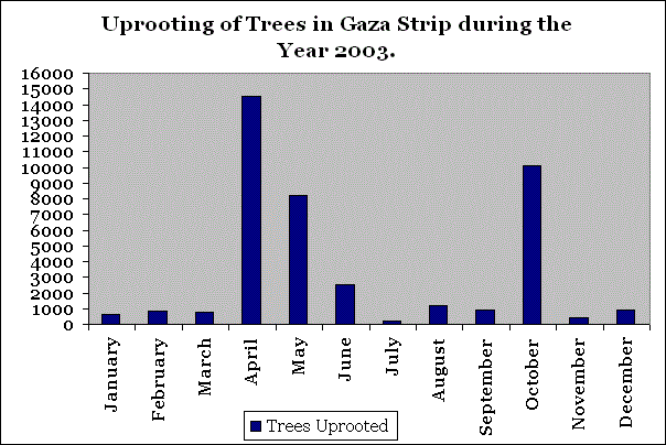
In the year 2003, Gaza trip has witnessed harsh Israeli measures starting from levelling and razing of lands and ending up with uprooting of thousands of Citrus and other fruitful trees conducted under many pretexts of which security was the most. The table below shows the Israeli violations including land confiscation and uprooting of trees during the year 2003 in Gaza Strip.
|
Month |
||
|
January |
615 |
90 |
|
February |
860 |
60 |
|
March |
800 |
0 |
|
April |
14530 |
517 |
|
May |
8240 |
549 |
|
June |
2547.5 |
200 |
|
July |
240 |
17 |
|
August |
1213 |
110 |
|
September |
884 |
64 |
|
October |
10138 |
857 |
|
November |
393 |
57 |
|
December |
943 |
103 |
|
Total |
30314 |
2624 |
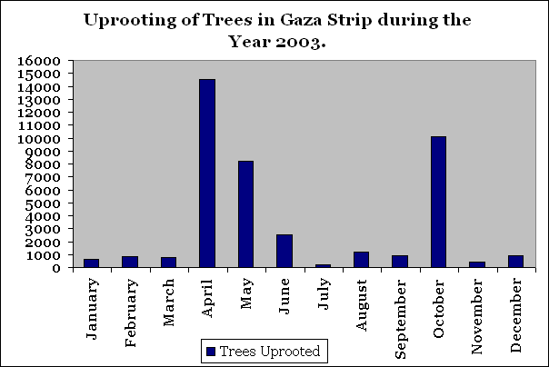
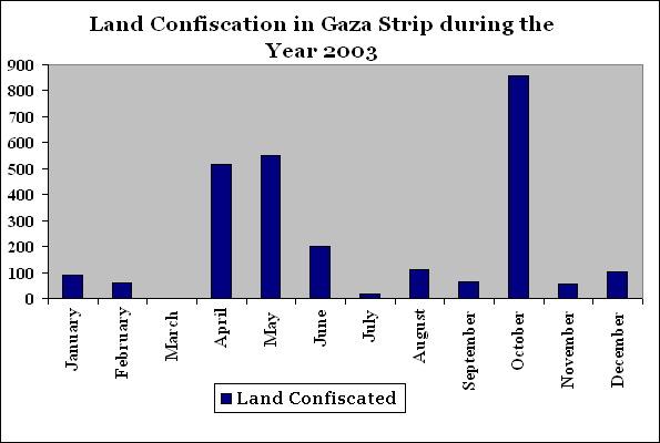
Source: ARIJ Database 2004
Seeking the protection of settlers in Israeli settlements and alluding to a variety of justifications, the Israeli government started executing in September 2003 a concrete Segregation Wall of 7 km length and 8 meters high in Rafah city similar to the wall that is being built in the West Bank. Going on with its plan, most Palestinian agricultural lands located adjacent to settlements or settlements' bypass roads network faced the threat of confiscation. For more information, click here.
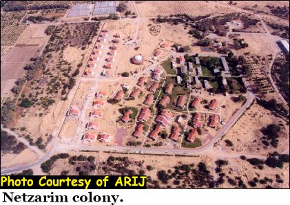
Recently, on the 22ed of February 2004, Israeli military southern commander, Dan Harel, handed Abu Maddin family living near Natzarim settlement south of Gaza city written military orders along with diagrams and maps stating the Israeli intention to confiscate 27 dunums (560 meters long, 15 meter width) of their agricultural land to build a new security wall in the southern part of the settlement, as provided by the Israelis. See military order and map as provided by the Israelis.
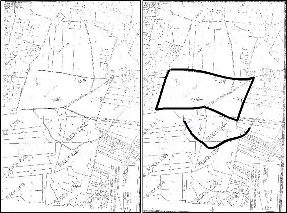
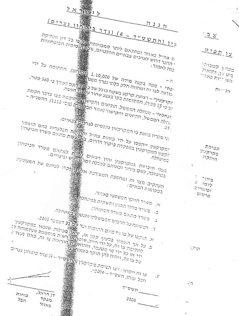
The confiscation will actually result in isolating 300 dunums of agricultural lands belong to the Islamic Waqf in Gaza and located between the security wall and the Netzarim settlement. According to ARIJ GIS data analysis, the Wall which is currently in its first stages of construction is going to be 1400 meters long; thus opposing Israeli declarations of '560 meter long' Wall. Families were given seven days to appeal to the Israeli Supreme court. See map of Wall

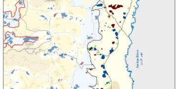
The areas targeted for confiscation are located near the vicinity of settlements that are planned to be evacuated from Gaza Strip according to the Israeli PM Ariel Sharon declarations in January 2004 to withdraw from 17 Israeli settlements out of 21 located in the Gaza Strip and accommodating 7,500 Israeli settlers in a maximum duration of one year. See translation of military order below
Military Order's Translation
Israel Defense Forces
Order to Seize lands (4-2004) (Netzarim Security Wall)
According to my authorities as a Military Chief Commander in the Region and as I believe that it is imperative for military reasons due to the special security situation in the region, I order the following:
1. The ''Map'' signed with a scale of 1: 10,000 and attached to the order is an essential part of this order. The ''Lands'': An area of land which is 27 dunums (560m length and 15m width) marked in black on the back of the map.
2. I announce by, that the above mentioned lands are seized for military reasons.
3. The IDF seizes the lands and have an absolute control over it and are given to the southern command officer of lands who is responsible in the ministry of defense.
4. Copies are given by the District Co-ordination Office ''DCO'' to land owners.
5. Copies of military orders and maps can be found in the following places
· District Co-ordination Office ''The DCO''
· Offices of the Juridical advisor in the region
· The office of commander responsible in the ministry of defense in the civil administration.
· Office responsible of absentee and public lands in the civil administration.
6. Land owners have the right to go to the DCO in Gaza to get more information about their right of land use expenses and compensation.
7. The Validity of this order starts at the date signed till 31/12/2005
8. The name of this order is: '' Order to seize lands (T.Sh. S. D-2) (Netzarim Security Wall- Gaza) 2004
Dan Harel the head of the Israeli military southern command,
The Israeli Defense Forces
Signature
Further confiscation of Palestinian lands in the Gaza Strip actually means the expansion of the Israeli settlement which contradicts with Prime Minister Ariel Sharon's intention of withdrawal. But if his intention is honest, the question remains: what is the reason behind the expansion of Netzarim settlement!!! ?
However, this Israeli measure breaches the agreements signed with the Palestinians as well as the fourth Geneva Convention in 1949, Article 33: No protected person may be punished for an offence he or she has not personally committed. Collective penalties and likewise all measures of intimidation or terrorism are prohibited. Pillage is prohibited, reprisals against protected persons and their property are prohibited.
Related Articles:
- To Pullout from Gaza! A Daring Step or Just a Tactical One
- Israeli Security on the Expense of Palestinian human Rights
- Intensification of house demolition campaign in Gaza Strip during the year 2003.
Prepared by:
The Applied Research Institute – Jerusalem


