• About The Project
  • Palestine in Century
  • Selected Maps
  • Glossary
  • About ARIJ
  • About LRC
  • By Year
    • Case Studies By Year
    • Daily Report By Year
Thursday, October 2, 2025
POICA
No Result
View All Result
  • Home
  • Settlements
    • New Israeli Settlements
    • Settlement Expansion
  • Israeli Violations
    • Agriculture
    • Confiscation
    • Demolition
    • Environment
    • Eviction of Palestinians
    • Settlers Attacks
  • Bypass Roads
  • Israeli Plans
  • Segregation
    • Checkpoints
    • Closure
    • Separation Plans
  • Military Orders
  • Reports
    • Daily Report
    • Monthly Report
    • Quarterly Report
No Result
View All Result
POICA
No Result
View All Result

Impact of Segregation Wall on Silat Al Harithiya town

February 19, 2004
in Segregation
Impact of Segregation Wall on Silat Al Harithiya town


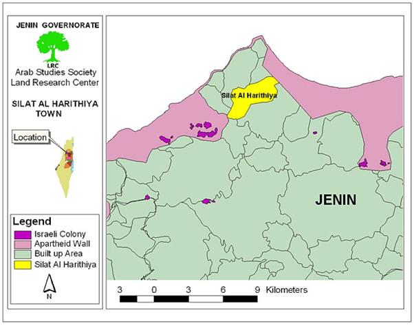
Location and population: the town of Silat Al Harithiya is located 8 km to the southwest of Jenin city. Its population is estimated at 10000 people, mostly working in agriculture.

Town area: Silat Al Harithiya total area is 13000 dunums (one dunum equals 3250 acers) of which 200 dunums were confiscated by the Israeli government for the construction of the Segregation Wall where the town's built up area is 2500 dunums.

The Wall and Silat Al Harithiya town:

The newly constructed Segregation Wall was built on a ''2 km long'' land to the west of the town. See map of Silat Al Harithiya


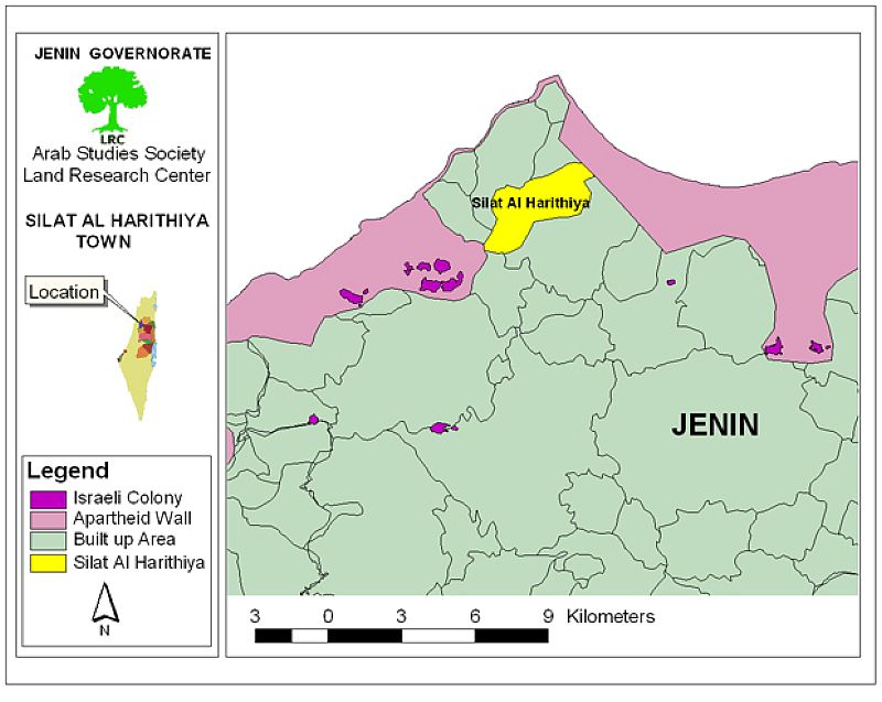
The town of Silat Al Harithiya to the north west of Jenin city


On April 28th2003, citizens of Silat Al Hartheyia were informed of the Israeli military order to confiscate lands of Ben 'Amer plain for the purpose of constructing the Wall in the area. One month later, specifically on May 23rd, 2003, the Israeli bulldozers backed by military troops started to destroy the land preparing for the construction of the wall.  The confiscated land is flat and was cultivated with cereals such as wheat, humus, and lentil. Clover and sesame were also amongst the crops destroyed.

Impact of the wall on People and Land:-

Impact on agriculture: Most of the town's land is agricultural and is divided into:

  • 950 dunums flat land;

  • 8000 dunums mountainous land;

  • 10 dunums green houses.

In addition to the land confiscated for constructing the wall, the following problems arose:

1- Marketing problems: Before the Intifada, farmers used to sell their products in local markets and markets inside Israel. Nowadays, the only possibility is to sell the products in local markets which suffer economic recession due to the ongoing closure and construction of the Wall.

2-  Farmers face difficulties in getting fertilizers, pesticides, and agricultural material and equipments as a result of cutting off roads and constructing the wall.

Impact on the economy:

1- Depriving 600 workers from reaching their workplaces inside Israel;

2- The destruction and confiscation of land has led to further deterioration in the economic situation and an increase in unemployment rate.


Prepared by
The Land Research Center
LRC


Recommended For You

عقاب جماعي يومي: الفلسطينيون تحت هيمنة الحواجز العسكرية

by arij
September 24, 2025
0
عقاب جماعي يومي: الفلسطينيون تحت هيمنة الحواجز العسكرية

تشهد الضفة الغربية المحتلة واقعًا خانقًا نتيجة السياسات الإسرائيلية المتمثلة بفرض المزيد من الحواجز العسكرية اليومية والإغلاقات، والتي باتت أداة منهجية للسيطرة والتحكم بحياة الفلسطينيين اليومية، وليست مجرد...

Read moreDetails

العدالة المؤجلة ورأي بلا تنفيذ: من قرار المحكمة إلى واقع الضم

by arij
July 9, 2025
0
العدالة المؤجلة ورأي بلا تنفيذ: من قرار المحكمة إلى واقع الضم

مقدمة في التاسع من تموز 2004، أصدرت محكمة العدل الدولية، وهي الجهاز القضائي الرئيسي للأمم المتحدة، رأيا استشاريا تاريخيا اعتبرت فيه بناء اسرائيل لجدار الفصل في الاراضي الفلسطينية...

Read moreDetails

سلطات الاحتلال الإسرائيلي تفرض واقعا جيوسياسيا جديدا في منطقة شمال قطاع غزة المحتل

by arij
March 13, 2024
0
سلطات الاحتلال الإسرائيلي تفرض واقعا جيوسياسيا جديدا في منطقة شمال قطاع غزة المحتل

  أظهرت صور الأقمار الصناعية الصادرة عن برنامج مراقبة الأرض التابع للاتحاد الأوروبي (كوبرنيكوس) لقطاع غزة المحتل في العاشر من شهر اذار من العام 2024، ان سلطات الاحتلال...

Read moreDetails

الحرب على قطاع غزة وتأثيرها على محافظة الخليل جنوب الضفة الغربية

by arij
November 30, 2023
0

  تقع محافظة الخليل في الجزء الجنوبي من الضفة الغربية المحتلة، إلى الجنوب من مدينة القدس، وعلى بعد حوالي 36 كم منها. يحدها من الشمال محافظة بيت لحم،...

Read moreDetails

تطبيق سياسة الفصل العنصري على استخدام الطرق الرئيسية في الضفة الغربية وتقيد حركة وتنقل المواطنين الفلسطينيين

by arij
November 22, 2023
0
معاناة شجرة الزيتون الفلسطينية بسبب الاحتلال والاستيطان في العام 2023

  بناء على تقديرات مراقبين دوليين يبلغ عدد الحواجز الإسرائيلية في الضفة الغربية أكثر من 567 حاجز إسرائيلي متعددة الاشكال منها 77 حاجزًا رئيسيًا وجزئي تتحكم في حركة...

Read moreDetails
Next Post
Israel’s systematic war against historical Palestinian buildings

Israel's systematic war against historical Palestinian buildings

LATEST NEWS

Annexation of the Jordan Valley: Implications for the Two-State Solution and Regional Stability

Annexation of the Jordan Valley: Implications for the Two-State Solution and Regional Stability

by arij
September 29, 2025
0

........................................................

Isolation of Three Villages Northwest of Jerusalem: Silent Annexation Creeps toward the Capital

عزل ثلاث قرى فلسطينية شمال غرب مدينة القدس: الضم الاسرائيلي الصامت يزحف نحو محيط العاصمة

by arij
September 24, 2025
0

........................................................

Isolation of Three Villages Northwest of Jerusalem: Silent Annexation Creeps toward the Capital

Isolation of Three Villages Northwest of Jerusalem: Silent Annexation Creeps toward the Capital

by arij
September 24, 2025
0

........................................................

سياسات التهويد في القدس: من السيطرة المكانية إلى طمس الهوية عبر التسمية

سياسات التهويد في القدس: من السيطرة المكانية إلى طمس الهوية عبر التسمية

by arij
September 23, 2025
0

........................................................

flag_yellow_lowEU-PfP-Logo

This website and its content were initiated in 1993 by the Applied Research Institute – Jerusalem (ARIJ) and the Land Research Center (LRC) with the support from the European Union up until 2023. Since then, the Applied Research Institute – Jerusalem (ARIJ) has taken over the continued development and maintenance of the website. The views expressed remain solely those of ARIJ) and do not necessarily reflect those of the European Union.

© 2025 Copyright ARIJ . All Rights reserved. .

No Result
View All Result
  • Home
  • Settlements
    • New Israeli Settlements
    • Settlement Expansion
  • Israeli Violations
    • Agriculture
    • Confiscation
    • Demolition
    • Environment
    • Eviction of Palestinians
    • Settlers Attacks
  • Bypass Roads
  • Israeli Plans
  • Segregation
    • Checkpoints
    • Closure
    • Separation Plans
  • Military Orders
  • Reports
    • Daily Report
    • Monthly Report
    • Quarterly Report

© 2025 Copyright ARIJ . All Rights reserved. .