Prepared by
Jad Isaac, Nael Salman, Nader Hrimat, Khaldoun Rishmawi, Majed Abu Kubi, Iyad Abu Rdeineh, Issa Zboun, Roubina Ghattas, Fuad Ishaq, Juliet Bannoura, Helen Ghawali.
Contents
1. Preface
2. Historical background
3. The Israeli plans to colonize the Occupied Palestinian Territories
3.1 – Alon Plan 3.2 – Gush Emunim Plan 3.3 – The Drobless Plan 3.4 – Sharon Plan 3.5 – The 'Hundred Thousand' Plan 3.6 – The Israeli governments' role in the colonization process
4. Growth of Israeli settlements and bypass roads in the Palestinian Territories
4.1 – Settlements increase and expansion 4.2 – Evidence of new Israeli outposts in the West Bank 4.3 – Israeli Bypass roads in the Palestinian Territories 4.3.1 – The growth of Israeli settlements4.3.2 – Financial allocations given for settlers and settlements in 2001 4.3.3 – Financing Israeli colonization in the Palestinian Territories in 2003
5. The Geopolitics of the Peace Accords
5.1 – The First Intifada 5.2 – The second Intifada 5.3 – President Clinton's Parameters for a final status agreement between Palestinians and Israelis
6. Israel's segregation of the Palestinian communities
6.a:Israel's segregation of the Palestinian communities
6.b: Map 13: The West Bank 64 segregated cantons
6.c:Figure 3: A satellite image showing the shaving of trees in the Gaza Strip
6.d:Map 16: Israel's Security zone in the West Bank, 2002
7. The Segregation Wall
7.1 The Segregation Wall in the West Bank
7.2 The Segregation Wall that envelopes Jerusalem
a-The southern part of the Segregation Wall b- The Eastern part of the Segregation Wall in Jerusalem
c-The Northern Part of Jerusalem Envelope
7.3 The new phases of the Segregation Wall to trap Palestinians in enclaves as provided by the Israeli Government
7.4 The Wall in Bethlehem Governorate
7.5 The full extent of the segregation Zones in the West Bank
7.6 The Palestinian Districts affected by the Segregation wall in phase 1
7.6.1 Jenin Governorate
7.6.2 Tulkarm Governorate
7.6.3 Qalqiliyia Governorate
7.6.4 Bethlehem Governorate
7.6.5 Hebron Governorate
7.7 The Socio- economic implications of the Segregation Wall in Phase 1…
7.8 Demolition campaigns entailed in construction of the Segregation Wall …
7.9The Impacts of Israel's Segregation Zone plan in the West Bank on the Palestinian Agriculture
7.10 Impact of Israel's Segregation Zone in the West Bank on the Palestinian Biodiversity
8. The Segregation Wall in Gaza Strip
9. Conclusion
10. Appendix 1
11. Appendix 2: Chronology of Israeli actions related to the Segregation Zone May 2002 – March 2003
12. Appendix 3: Chronology of Israeli actions related to the Segregation Zone April 2002 – November 2003
13. List of References
List of Maps:-
Map 1: A map showing the direction of the Segregation Wall in phase IMap 2: UN Resolution 181, partition plan of 1947
Map 3: The changing boundaries of JerusalemMap 4: Alon Plan to colonize the West BankMap 5: Israel Strategic Interests in the West BankMap 6: Israeli settlements and outposts in the West Bank 2003Map 7: Land fragmentation and restriction of movementMap 4: Alon plan proposed after 1967 to colonize the Jordan valleyMap 8: Israeli bypass roads and road blocks in the West4.3 The growth of Israeli settlementsMap 9: Qslo I Agreement Between, May 1994 Map 10: 'Oslo II' agreement of September 28 1995Map12: Final Status map presented during negotiations by Israel, May 2000Map 11: Sharm Esh Sheikh Memorandum Phase Three, MarchMap 13: The West Bank 64 segregated cantonsMap 14: Segregating the GazaMap 15: The Gaza Strip divided into 3 cantonsMap 16: Israel's Security zone in the West Bank, 2002Map 17: Segregation Wall Phase 1, northwest of West Bank, 2003 Map 18: Map of the Segregation Wall (Phase 1)Map 19: Changing the path of the Segregation WallMap 20: the segregation Wall north of Bethlehem Map 21: the wall at the northern entrance of Bethlehem near Rachel's Tomb
Map 22: A 3-D representation of the Wall according to the adjusted military order that was issued on August 7, 2003
Map 23: Map of Al Walaja and Beit Jala citiesMap 24: The Segregation Wall and the newly issued Israeli military orders around Jerusalem (Source: ARIJ, August 2003).
Map 25: Map of Jerusalem municipality borders
Map 26: Satellite images of Al Khas and Al-Nu'man since 1967
Map 27: Map of military order concerning Al-Khas & Al-Numan villages
Map 28: Map of military orders.
Map 29: Map of the Segregation path.
Map 30: Map Segregation Wall in Ramallah District
Map 31: Metropolitan Jerusalem
Map 32-a: Segregation Wall around Jerusalem
Map 32-b: Updated map of the Segregation Wall
Map 33-a: The Segregation Wall in Bethlehem Governorate
Map 33-b: Slaying the western side of Bethlehem
Map 34: The Israeli segregation zone plan in the West Bank
Map 35: Satellite image of the Jordan Valley
Map 36: Israeli military bases and closed military areas
Map 37: Area closed-off by Israeli checkpoints and roadblocks in the Jordan Valley.
Map 38: Sharon's strategic interests
Map 39: Jenin district
Map 40: Districts of Tulkarm and Q1alqiliyia.
Map 41: Map of the Segregation Wall in Qalqilyia (41)
Map 42: Segregation Wall and Palestinian Water Resources
Map 43: Isolated land use typed by the Segregation Wall
Map 44: Impact of the Israeli Segregation Zone Plan on Palestinian biodiversity
Map 45: a map showing the part of the Segregation Wall in Rafah city
Map 46: The devastated area in Rafah Camp
List of Tables:-
Table 1: the growth of settlement Areas in the West BankTable 2: Areas controlled by Israel in the Gaza StripTable 3-a: Increase in settlements' areas in north Gaza Governorate 2001-2003Table 3-b: Increase in settlements' areas in Gaza Governorate 2001-2003Table 3-c: Increase in settlements' areas in Khan Younis Governorate 2001-2003Table 3-d: Increase in settlements' areas in Rafah Governorate 2001-2003 Table 4: Outposts established after Aqaba summit 3rd of June 2003 and still existTable 5: New outposts established after the 3rd of June 2003 and dismantled
Table 6:- Numbers of checkpoints, roadblocks, Wall Gates and Trenches in the West Bank.
Table 7: The Redeployment percentages according to the agreements3Table 8: Agricultural lands and trees segregated from the West Bank behind the Segregation Wall in Phase 1, 2003
Table 9: localities imprisoned between the Segregation Wall and the Secondary one
Table 10: Table of military orders
Table 11: shows the lengths of the constructions phases of the main Segregation wall
Table 12: shows the total number of Israeli settlements contained in the main and secondary Segregation Zones in the West Bank in phases 1 to 4
Table 13: shows the number of Palestinian communities and population trapped in the segregation zonesTable 14: Palestinian communities that are trapped between 2 segregation walls, main and secondary (depth): (Sources: ARIJ, November 2003)
Table 15: shows the Palestinian communities which will be enclaved in Ghettos as a result of implementing the Segregation wall
Table 16: Palestinian localities inside the main and secondary wall excluding east Jerusalem
Table 17: Number of Israeli settlements contained by the main and the segregation Wall excluding east Jerusalem
Table 18: Israeli settlements in the Jordan Valley
Table 19: Palestinian localities in the Jordan Valley
Table 20: Table of events
Table 21: The segregated Palestinian communities west of the Segregation Wall, population, and the available social services
Table 22: The affected Palestinian villages on both sides of the Segregation Wall Table 23: Data on Palestinian artesian wells located inside the Secondary (depth) Segregation Zone, which Israel is implementing inside the Palestinian West Bank
Table 24: Data on Palestinian artesian wells located inside the Main Segregation Zone, which Israel is implementing inside the Palestinian West Bank
Table 25: Total land use and land cover used for the Segregation ZoneTable 26: Total Agricultural threatened areas in dunums, annual production in tons and value in $US in the Easter part of the Israel's segregation zone.
Table 27: Total Agricultural threatened areas in dunums, annual production in tons and Value in $US in the Western part of the Israel's segregation zone
Table 28: Total Agricultural threatened areas (Dunum), annual production (ton) and value in US$ in the Israeli anticipated Segregation zone.
Table 29: Forests included in the Eastern part of the Segregation ZoneTable 30: Forestsincluded in the Western part of the Segregation Zone
List of Photos:-
Photo 1: New Israeli erected settlement Outposts on Palestinian Lands in the West Bank
(Ofra outpost (left))
Photo 2: New Israeli erected settlement Outposts on Palestinian Lands in the West Bank
(Eli output (right))
Photo 3: TheSegregation Wall 6-8 meters high west of Qalqiliya city, 2003
Photo 4: The Segregation Wall north of Bethlehem city, ARIJ,
August 2003
Photo 5 & Photo 6: Work continues in the Segregation Wall East of Beit Sahour, Bethlehem Governorate, ARIJ, and August 2003
Photos 7 & 8: Construction of the segregation wall near Rachel's Tomb 20/10/2003
Photo 9 & Photo 10: 'Der Almahaba', 'Der Gargoury' and 'Der Beit Fajey' in Al-Eizariya.
Photo 11 & Photo 12: Palestinian residential areas splited into two parallel entities
Photo 13 & photo 14: 'Hajiz Al-Bawabeh' the Gate's Checkpoint.
Photo 15 & photo 16: The Gate's Checkpoint
Photo 17 & photo 18: people cross and that translates into hours of waiting under the burning sun where many fainted.
Photo 19 & photo 20: People riskily climbing the wall from both sides trying to get to their work, school,:
Photo 21: Qalandia airport will be annexed and totally controlled by the Israeli Authorities
Photo 22: Works continue to erect the Segregation Wall near Ramallah Villages
Photo 23 & Photo 24: Rafat village lands after the land confiscation for different Israeli security and military purposes
Photo 25, Photo 26 & Photo 27: 50 families were left homeless in Rafah City.
List of Figures:-
Figure 1: The myth of natural growth in Israeli settlements in the Palestinian Territories
Figure 2: Israeli Colonization in the West Bank according to Israeli Palestinian agreements
Figure 3: A satellite image showing the shaving of trees in the Gaza Strip
Figure 4: Groundwater quantities used for irrigation in various West Bank areas.
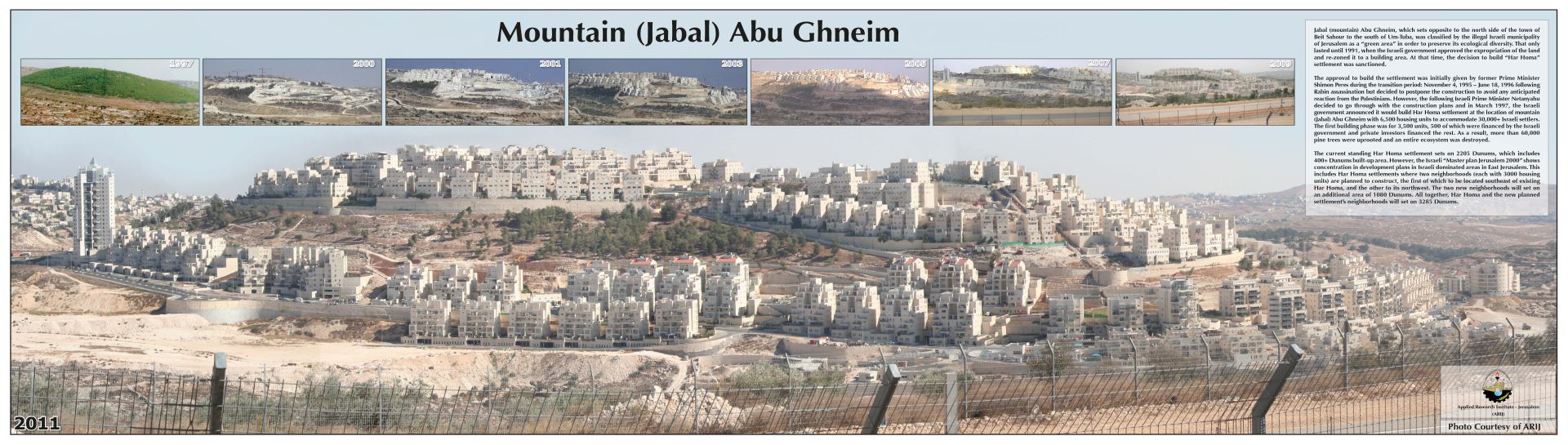
Figure 5: Abu Ghneim Mountain from a natural forest to an Israeli settlement
Figure 6: shows the number of trees uprooted in the West Bank by the IOF during the year 2002.
Month
Figure 7: shows the number of trees uprooted in the West Bank by the IOF during the years 2003.
Figure 8: shows the number of houses demolished in the West Bank by the IOF and settlers during the year 2002
Figure 9: shows the number of houses demolished in the West Bank by the IOF and settlers during the year 2003
Figure 10: shows the number of confiscated lands in the West Bank by the IOF and settlers during the years 2002.
Figure 11: shows the number of confiscated lands in the West Bank by the IOF during the years 2003
Figure 12: The expected agricultural loss due to the Israeli segregation zone in the West Bank
Prepared by:
The Applied Research Institute – Jerusalem