• About The Project
  • Palestine in Century
  • Selected Maps
  • Glossary
  • About ARIJ
  • About LRC
  • By Year
    • Case Studies By Year
    • Daily Report By Year
Sunday, May 11, 2025
POICA
No Result
View All Result
  • Home
  • Settlements
    • New Israeli Settlements
    • Settlement Expansion
  • Israeli Violations
    • Agriculture
    • Confiscation
    • Demolition
    • Environment
    • Eviction of Palestinians
    • Settlers Attacks
  • Bypass Roads
  • Israeli Plans
  • Segregation
    • Checkpoints
    • Closure
    • Separation Plans
  • Military Orders
  • Reports
    • Daily Report
    • Monthly Report
    • Quarterly Report
No Result
View All Result
POICA
No Result
View All Result

The snaking Wall enters area (A) in Bethlehem

December 4, 2003
in Segregation
The snaking Wall enters area (A) in Bethlehem

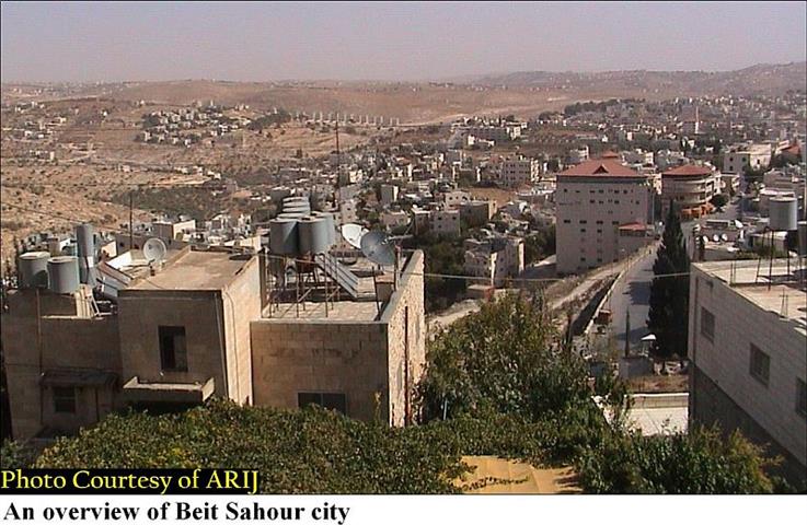
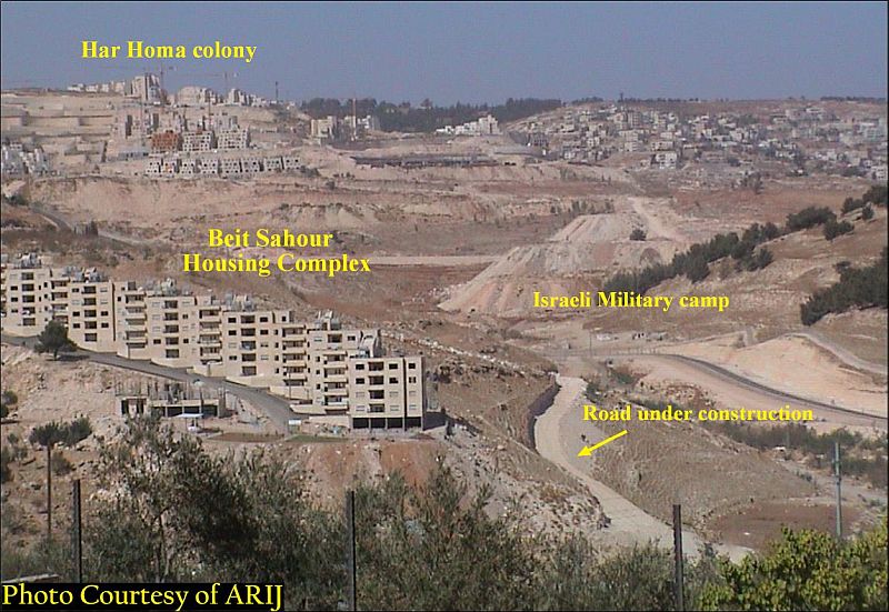
The town of Beit Sahour,''the house of vigilanc'' lies on the northern edge of Bethlehem. It has 14.465 inhabitants, Christians and Moslems all living together in peace. Its name stems from the Canaanite words 'beet' meaning place, and 'Sahour' meaning night watch. Its name reflects the  importance of the area for shepherds as a grazing area during day-time as well as a shelter for the flocks at night in the existence caves. See Photo 1

Like the other areas of most Palestinian villages and cities, Beit Sahour has been faced up with the Israeli campaign to construct the Segregation Wall. Below is a chronology of events

Chronology of events

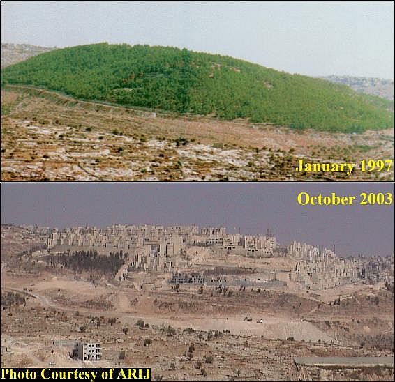
On June 6, 1995: Israel's Minister of Finance, Mr. Isaac Moda'ee, ordered the confiscation of land on and around the forested mountain of Abu Ghnaim, located less than two kilometers north of Bethlehem city, even though these lands are privately owned by Palestinian families from Bethlehem, Beit Sahour, and the villages of Um Tuba and Sur Baher, the Settlement of Har Homa (Abu Ghneim)is planed to contain more than 6500 housing units, restaurants, schools and hotels. The confiscation order was based on''Lands Law of 194'' which authorizes the Minister to confiscate lands for public use. The term, 'public use', is used to excuse the construction of the Israeli Settlers for the use of Israeli settlersis planed to contain more than 6500 housing units, restaurants, schools and hotels. The confiscation order was based on''Lands Law of 194'' which authorizes the Minister to confiscate lands for public use. The term, 'public use', is used to excuse the construction of the Israeli Settlers for the use of Israeli settlers. See Photo 2


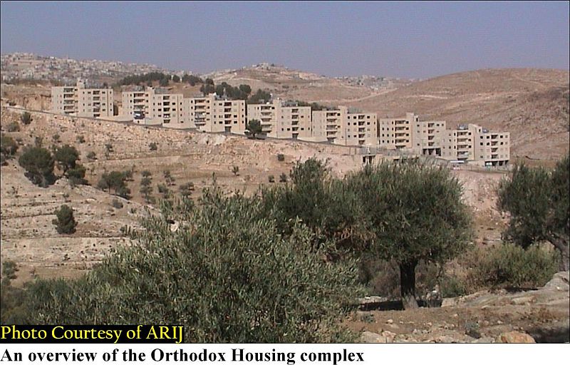
In 1995: the construction of the Orthodox Housing Complex started after the late Patriarch Theodorus accepted to lease that plot to the housing project for 99 years at favor to help the limited income households in Beit Sahour community. See Photo 3 & Photo 4


In the year 2002: the Israeli Occupation Authorities decided to erect the Segregation Wall around Bethlehem district where a major part of it is circulating Beit Sahour city.

In September 2002: the Israeli Authorities decided to demolish the Orthodox housing complex which is located in area C and is passing close the Segregation Wall conducted under the pretext of not having building permits from the Israeli administration of Beit Il in Ramallah, considering the area under their control (Area C) which means ''no construction is allowed on it''. Fortunately, the international and local pressures on the Israeli Authorities were able to freeze the demolition decision. Related articles

On August 25, 2003: the Israeli bulldozers commenced the construction of the secondary military road that enclaves the Orthodox Housing complex, which is composed of 7 apartment buildings, each contains 8 housing units each with an area of 1071 square meters and  is currently inhabited by 24 families.

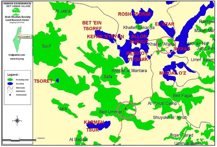
The Segregation Wall path constructed in Bethlehem District is 10.5km length, whereby a segment of 480m was constructed in area A. This segment is located within Bethlehem Municipality borders and has an area of 22.2 Dunums of land. See Map 1


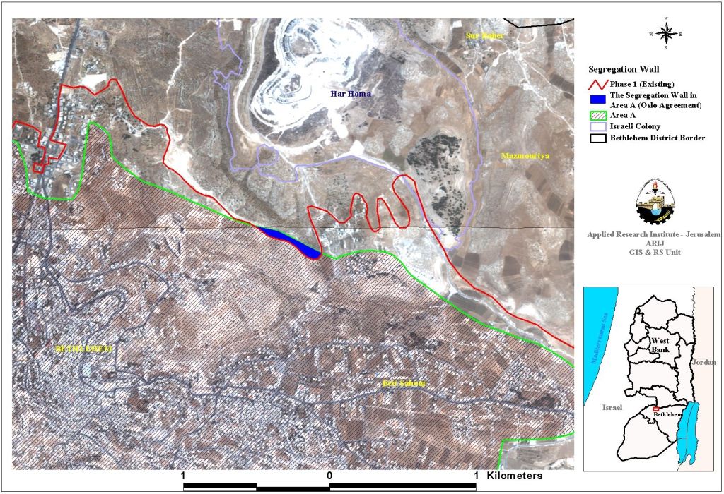
This shows how Israel dissembled the spirit of the signed agreements through using them to authorize its further occupation of the Palestinian lands.

According to Oslo II interim agreement that was signed in September 1995 between the Palestinians and Israelis, the Palestinian governorates were divided into three areas A, B and C aiming at a phasing withdrawal of the Israeli forces from those areas until the accomplishment of a final status agreement.

Area (A): the Israeli army has pulled out fully and all responsibilities for internal security and Public order are held by Palestinians.

Area (B): Palestinians have full control over the civil administration and Israel continues to have overriding responsibility for security.

Area (C): the Palestinians have responsibility for civil life such as economics, health and education; however Israel retains full control over security and administration related to territory. See map of Oslo II agreement

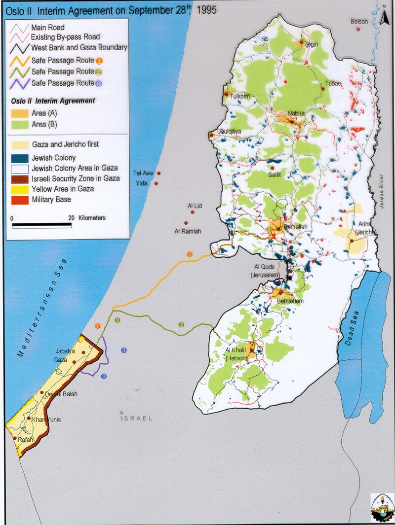
Table 1: Oslo II interim agreement

Area Population 2002  Area km2  Area in %
Area (A) 92449 47,6  6
Area (B) 49378  33,8 4
Area (C) 8710  424 52
Natural Reserves —–  102,4 13
Total 150573  807,8 —


The construction of the Segregation Wall has not only destroyed most of agricultural land, demolishing of houses but also leaves the surrounding Palestinian villages with little land to hold the natural population growth and to prevent the contiguity of any Palestinian state in the future.


Prepared by:
The Applied Research Institute – Jerusalem


Recommended For You

سلطات الاحتلال الإسرائيلي تفرض واقعا جيوسياسيا جديدا في منطقة شمال قطاع غزة المحتل

by arij
March 13, 2024
0
سلطات الاحتلال الإسرائيلي تفرض واقعا جيوسياسيا جديدا في منطقة شمال قطاع غزة المحتل

  أظهرت صور الأقمار الصناعية الصادرة عن برنامج مراقبة الأرض التابع للاتحاد الأوروبي (كوبرنيكوس) لقطاع غزة المحتل في العاشر من شهر اذار من العام 2024، ان سلطات الاحتلال...

Read moreDetails

الحرب على قطاع غزة وتأثيرها على محافظة الخليل جنوب الضفة الغربية

by arij
November 30, 2023
0

  تقع محافظة الخليل في الجزء الجنوبي من الضفة الغربية المحتلة، إلى الجنوب من مدينة القدس، وعلى بعد حوالي 36 كم منها. يحدها من الشمال محافظة بيت لحم،...

Read moreDetails

تطبيق سياسة الفصل العنصري على استخدام الطرق الرئيسية في الضفة الغربية وتقيد حركة وتنقل المواطنين الفلسطينيين

by arij
November 22, 2023
0
معاناة شجرة الزيتون الفلسطينية بسبب الاحتلال والاستيطان في العام 2023

  بناء على تقديرات مراقبين دوليين يبلغ عدد الحواجز الإسرائيلية في الضفة الغربية أكثر من 567 حاجز إسرائيلي متعددة الاشكال منها 77 حاجزًا رئيسيًا وجزئي تتحكم في حركة...

Read moreDetails

The Instigation of Apartheid Roads Era: Israel blocks Palestinian movement inside West Bank Governorates

by arij
November 22, 2023
0

  According to international observers, Israel constrains the West Bank territory with 567 various types of obstacles; 77 of which are main checkpoints and partial checkpoints that control...

Read moreDetails

Between “Ben Gavir” and Netanyahu Not Oblivious but Vindictive, The reality of Israeli Apartheid Stands in the occupied Palestinian territory

by arij
September 13, 2023
0
Between “Ben Gavir” and Netanyahu Not Oblivious but Vindictive, The reality of Israeli Apartheid Stands in the occupied Palestinian territory

  In the wake of the overwhelming Israeli settlers and the Israeli occupation government increasing their wave of attacks and assaults on the Palestinian people (more than 700...

Read moreDetails
Next Post
30 dunums of Beit Ummer agricultural land confiscated for colonial road construction

30 dunums of Beit Ummer agricultural land confiscated for colonial road construction

LATEST NEWS

الأراضي الفلسطينية بين الذرائع الأمنية والأطماع الاستيطانية – “الأمن، الآثار، والطبيعة كحجج لاقتلاع الفلسطينيين من أراضيهم”

by arij
April 15, 2025
0

........................................................

الطرق الالتفافية الاسرائيلية وأثرها على البيئة الفلسطينية

انتهاك للطبيعة والهوية في الأراضي الفلسطينية المحتلة

by arij
March 17, 2025
0

........................................................

Israel Advances Settlement Plan on Ancient Olive Groves on lands of Beit Jala city, Violating International Law and depriving Palestinians their lands

إسرائيل تمضي قدمًا في مخطط استيطاني جديد على أراضي مدينة بيت جالا، في انتهاك للقانون الدولي وحرمان الفلسطينيين من أراضيهم

by arij
April 29, 2025
0

........................................................

Israel Advances Settlement Plan on Ancient Olive Groves on lands of Beit Jala city, Violating International Law and depriving Palestinians their lands

Israel Advances Settlement Plan on Ancient Olive Groves on lands of Beit Jala city, Violating International Law and depriving Palestinians their lands

by arij
April 29, 2025
0

........................................................

flag_yellow_lowEU-PfP-Logo

This website has been produced with the assistance of the European Union. The contents of this publication are the sole responsibility of ARIJ & LRC and can in no way be taken to reflect the views of the European Union.

© 2025 Copyright ARIJ . All Rights reserved. .

No Result
View All Result
  • Home
  • Settlements
    • New Israeli Settlements
    • Settlement Expansion
  • Israeli Violations
    • Agriculture
    • Confiscation
    • Demolition
    • Environment
    • Eviction of Palestinians
    • Settlers Attacks
  • Bypass Roads
  • Israeli Plans
  • Segregation
    • Checkpoints
    • Closure
    • Separation Plans
  • Military Orders
  • Reports
    • Daily Report
    • Monthly Report
    • Quarterly Report

© 2025 Copyright ARIJ . All Rights reserved. .