Location:
Turmus 'Aya village is located 15.7 km to the northeast of Ramallah district and a built -up area of 1.3km2. (ARIJ GIS Data Base, 2003)
Population:
The village of Turmus 'Aya encompass a population of more than 4100 Palestinian inhabitants. (ARIJ database 2003)
Turmus 'Aya village:
Turmus 'Aya is an agricultural village where Palestinians consider their lands as a major source of income for their living. Palestinian farmers have always suffered from the Israeli harassments, especially those who live near the Israeli settlements especially since the beginning of the second Intifada that started in September 2000.
On December 13, 2003, a number of Israeli settlers living in the nearby settlement of Shilo located to the east of Turmus 'Aya village seized more than 1750 dunums of agricultural lands cultivated with Olive, Almond and Vine trees. The settlers used electronic hedges for the construction of the new Shevut Rahel outpost to the north of the above mentioned settlement. The confiscated Lands belong to more than 250 Palestinian farmers from the village, which have documents that certify their ownership of the land. The documents date back to the British mandate period and prove their right of ownership. Table 1 lists a number of Palestinian farmers who are affected by this violent action:
Table1: Name of landowners known
|
1. |
The Beneficiaries of Ahmad Muhammad El A'raj |
|
2. |
Sari Al A'raj and his brothers |
|
3. |
Sa'id Shoukry Za'tar |
|
4. |
The Beneficiaries of Qasem Abu Qafiya |
|
5. |
The Beneficiaries of Mahmoud Abu Qafiya |
|
6. |
Muhammad Rabe' and his brothers |
|
7. |
Suleiman 'Awad 'Abed El Qader and his brothers |
|
8. |
Hassan Habash and his brothers |
|
9. |
Salim Rabah and his brothers |
|
10. |
'Abed El Qader Ibrahim Heqaz |
|
11. |
The Beneficiaries of 'Ali Muhammad Al A'raj |
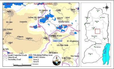
Palestinian farmers witnessed in this act another Israeli attempt to grab and annex more Palestinian lands to the Israeli borders. Such violent step will isolate the northern part of the West Bank from its midst, whereby constructing the new illegal outpost aims at connecting Shilo settlement with the neighboring settlements located to the east of the ''Northern valleys'' to then reach the western borders of the Armistice Line (Green Line). See Map

It is worth mentioning that the IOF added tens of caravans to the surrounding of Shilo, Ofra, Eli and Shevut Rahel settlements built on lands of Turmus 'Aya, Qaryout, Jalout, Al Mugheir and Singel Palestinian villages located between Ramallah and Nablus in oder to grab as much Palestinian open spaces and agricultural lands as possible. This Israeli plan not only hinders the village expansion, but also limits the Palestinian urban expansion in the West Bank as well. Table 2 shows the Israeli settlements located near Turmus 'Aya village
Table 2: Name of settlements surrounding the village
|
Settlement Name |
Date of establishment |
Area |
Population |
|
Shilo |
1978 |
859131.711 |
1757 |
|
Mizpe Rahel (Shvut Rahel) |
1992 |
428332.453 |
NA |
|
Eli |
1984 |
2584665.883 |
2869 |
Source: ARIJ GIS Data Base
Conclusion:
The policy of land confiscation to expand Israeli settlements or to construct new outposts has always been a major threat to Palestinian farmers through the aggressions of Israeli settlers against farmers who try to reach their lands, with the support of the Israeli Occupation forces (IOF) and to displace them from their own lands.
The owners of these lands do not know what the future is holding for them as the Israeli authority allows for such construction of illegal outposts and expansion of Israeli settlements which in turn shows a critical plan of keeping the West Bank areas isolated and disconnected. The farmers are faced with one of two difficult choices: either to stay in their land and face the nonstop suffering or leave.
Prepared by
The Land Research Center
LRC


