January 2002-December 2002
1. Introduction
'Monitoring Israeli Colonization Activities' is a project that was funded by the Commission of the European Communities during February 2000 and until February 2002; whereby a new proposal was submitted to the Commission of the European Communities to finance the project for another two years. The project however continued to be financed from the budget of the Applied Research Institute – Jerusalem (ARIJ) waiting for the submitted proposal to be approved. The project aimed at disseminating information on Israeli colonization by monitoring Israeli colonization activities through the collection of primary and secondary data, and by analyzing the data to assess the potential implications of such Israeli colonization activities on the process of the political negotiations between the Palestinian Authority and Israel. The project also studied the impact of Israeli colonization activities on the surrounding Palestinian communities, land use changes and environment.
The importance of this project stems from the centrality of Israeli colonization activities in determining the framework of the final solution of the Palestinian-Israeli conflict. As was evidenced, during Camp David II, the failure of addressing a just solution to the fate of the Israeli settlements in the West Bank and Gaza Strip as well as failing at finalizing the issues of Jerusalem, borders and the Palestinian refugees, culminated in the second Intifada, which erupted in late September 2000. Apparently, colonization activities that will be shown in this report have increased in both rate and number, further exacerbating the stalemate and the overall political turmoil in the area.
In this report, the trends of the Israeli colonizing activities are demonstrated through various methodologies: statistical and satellite image analyses. The first section of the report will give a geopolitical background to lend context to the sections that follow. The second section deals with statistical data, which will be analyzed by employing graphs and charts to show the trends in Israeli violations and the location of such violations. Finally, the third section provides the satellite image analysis for expansion of Israeli settlements.
2. Overview
2.1 The Geopolitical Background
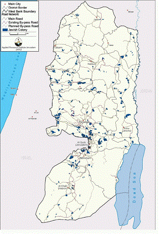
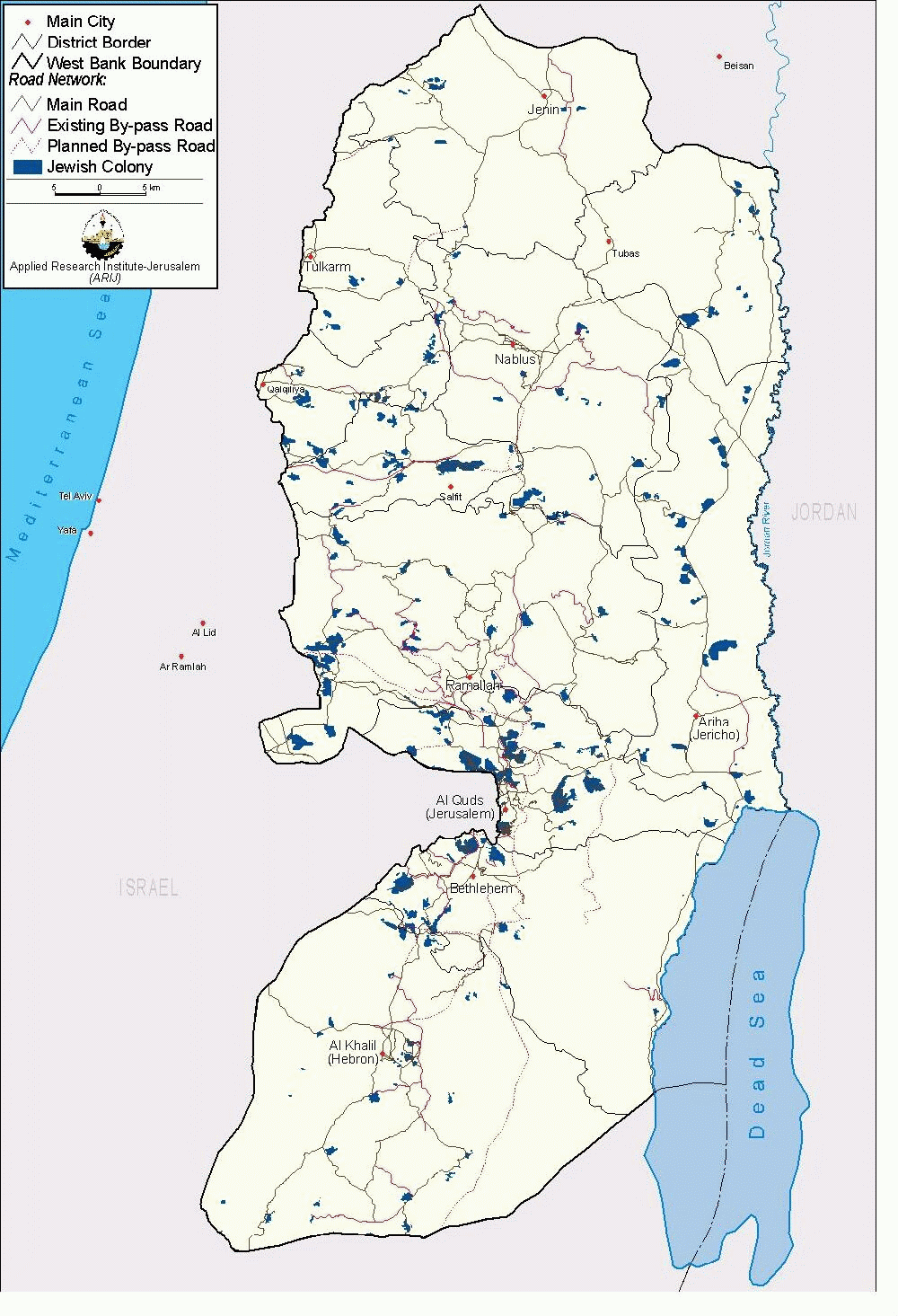
Since the 1967 occupation, Israel has either confiscated or declared as closed areas over 55% of the West Bank and 25% of the Gaza Strip, thereby placing those areas out of Palestinian reach. Palestinians are allowed to use less than 15% of their water resources. Israel has pursued a policy of colonizing Palestine through settlements, in an attempt to change its demographic character. Presently, there are 26 Israeli settlements in the Gaza Strip housing an estimated 6,429 Israeli settlers, 310 built up areas (Polygons) in the West Bank including East Jerusalem with a population of more than 415634 settlers, including 198332 reside in East Jerusalem, (GIS Database 2001). This is excluding military sites. Settlements are distributed all over the West Bank. See Figure 1.
In Jerusalem, Israel expanded the borders of East Jerusalem from 6.5 km² to 71 km² to cover areas from Ramallah and Bethlehem districts. Those borders were drawn to include as much vacant land and as less Palestinian built up areas as possible; See Figure 2

Today Israel is in complete control of the city, yet most of the property and real estate still legally belongs to the indigenous Palestinians who have been living continuously in Jerusalem for centuries. Israel's intensive development program after 1967 has involved the construction of new housing and associated infrastructures in the unilaterally annexed and expanded territory of occupied East Jerusalem. In addition, the Israeli Authorities evicted immediately following the 1967 war an entire neighbourhood named Al Maghareba and levelled it to the ground in order to make way for the Wailing Wall Plaza. Over the years, Israel has been able to take control over 55 locations in the old city of Jerusalem.
In 1987, the Intifada broke out carrying the message of rejecting the continuation of Occupation and at the same time, calling for a resolution to the historic conflict between the Israelis and Palestinians. Consequently, the Palestinian people, by and large, accepted the discourse of peaceful negotiations based on the grounds outlined in Madrid Conference in 1991. The guiding principles of these negotiations were 'Land for Peace' and the United Nations Resolutions 242 and 338. After several rounds of formal talks in Washington, the PLO and Israel were able to come out with the historic agreement of the Declaration of Principles (DOP), which was signed in September 1993.
The DOP called for an interim period of 5 years during which the representatives of the Palestinian people and the Israeli government will initiate negotiations over the final status, which include Jerusalem, refugees, settlements, borders and water. It was also agreed upon that neither party should initiate any action during the interim period that might jeopardize the outcome of final status negotiations. The 'Oslo II' agreement, signed in Washington D.C. in September of 1995, sets out the interim stage for Palestinian Autonomy in the West Bank and Gaza, pending 'final status negotiations' which were scheduled to begin in May 1996 and finish by May 1999.
The Interim Agreement states that the first phase of the Israeli military forces redeployment.. will be completed prior to the eve of the Palestinian elections, i.e., 22 days before the day of the elections. The further redeployments were to be completed within 18 months from the date of the inauguration of the Council. During this time, the powers and responsibilities relating to territory will be transferred gradually to Palestinian jurisdiction to cover West Bank and Gaza Strip territory, except for the issues that will be negotiated in the permanent status negotiations (i.e. Jerusalem and the Settlements). This meant that 95 % of the West Bank and Gaza should have become under Palestinian control, 18 months after the inauguration of the Council.
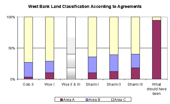
However, on the ground, neither of the above agreements happened. Stalling of negotiations and delays as well as renegotiation of what was already agreed upon led to partial Israeli withdrawals so that by March 2000 the areas under effective Palestinian control amounted to no more than 18.2 %. The following table outlines the various stages of the interim agreements and the changes that occurred to them.
Table 1: The Redeployment percentages according to the agreements
|
Agreement |
Date |
Area |
||
|
A |
B |
C |
||
|
Oslo II |
May 1994 |
3% |
24% |
73% |
|
Wye I |
October 1998 |
10.1% |
24 % |
71.0 % |
|
Wye II & III (not implemented) |
|
18.2 % |
21.8 % |
60.0 % |
|
Sharm I |
September 1999 |
10.1 % |
25.9 % |
64.0 % |
|
Sharm II (implemented in delay) |
January 2000 |
12.1 % |
26.9 % |
61.0 % |
|
Sharm III (implemented in delay) |
March 2000 |
18.2 % |
21.8 % |
60.0 % |
|
What should have been |
1997 |
95 % |
0 % |
5 % |
In July 2000, President Clinton hosted the Israeli and Palestinian leaders for a summit in Camp David in an attempt to revitalize the peace process through an agreement on a final status framework. This was the first real negotiation that tried to address final status issues. The Clinton parameters for a final status agreement related to settlements, borders and Jerusalem included the following:
Territory:
The solution should be in the mid-90 percents, between 94-96 percent of the West Bank territory of the Palestinian State. The land annexed by Israel should be compensated by a land swap of 1-3 percent in addition to territorial arrangements such as a permanent safe passage. The parties should consider the swap of leased land to meet their respective needs. The Parties should develop a map consistent with the following criteria:
-
80% of settlers in blocks
-
contiguity
-
Minimize the annexed areas
-
Minimize the number of Palestinians affected
Jerusalem:
The general principle is that: Arab areas are Palestinians and Jewish ones are Israelis. This would apply to the Old City as well. I urge the two sides to work on maps to create maximum contiguity for both sides. Regarding the HaramTemple Mount, I believe that the gaps are not related to practical administration but to symbolic issues of sovereignty, and to find a way to accord respect to the religious beliefs of both sides.
I know you have been discussing a number of formulations. I add to these two additional formulations guaranteeing Palestinian effective control over the Haram while respecting the conviction of the Jewish People. Regarding either one of those two formulations will be international monitoring to provide mutual confidence.
1. Palestinian sovereignty over the Haram and Israeli sovereignty over
a) the Western Wall and the space sacred to Judaism of which it is a part or
b) the Western Wall and the Holy of Holies of which it is a part.
There will be a firm commitment by both not to excavate beneath the Haram or behind the Wall.
2. Palestinian sovereignty over the Haram and Israeli sovereignty over the Western Wall and shared functional sovereignty over the issue of excavation under the Haram and behind the Wall such that mutual consent would be requested before any excavation can take place.
There will be a firm commitment by both not to excavate beneath the Haram or behind the Wall. Figure 3: shows a map that was given to the Palestinians during Camp David summit.
Palestinians could not accept such a proposal which totally negates UN resolutions 242 and 338 as well as the right of return and carves the West Bank to accommodate Jewish settlements and perpetuates Israeli control on large areas in East Jerusalem. On 28 September 2000, al Aqsa Intifada erupted following the provocative entry of Mr. Ariel Sharon to the sacred vicinity of Al Aqsa. The closure imposed by Israel on the Palestinian Territories since the beginning of the Aqsa Intifada has restricted the ability of Palestinians to travel and work to a degree unprecedented in the 34-year Israeli occupation of the West Bank and Gaza Strip. The internal closure separates Palestinian localities from each other and results in the hampering or complete freezing of the economic, political, educational, medical, and social service activities necessary for a healthy society. Such a cantonization of the Palestinian Territories is achieved through the use of roadblocks (including destroying the roads themselves), checkpoints, and military patrols, all built upon the skeleton of the Jewish settlements.
In an attempt to rescue the peace process, president Arafat launched an initiative to resume negotiations. In January 2001, Israeli and Palestinian negotiators held marathon negotiations in Taba. By then, Israeli elections were close and thus, the Israeli leadership could not take the necessary decisions. The Israeli side repackaged their old positions, which do not meet Palestinian aspirations. The Israeli side blamed the Palestinians for not accepting their 'generous' offer and played the percentage game claiming they offered the Palestinians more than 97 % of the West Bank. The fact is that Israel insisted on retaining the large settlement blocks of Modi'in, Gush Etzion, Ariel and Jerusalem, which account for more than 12 % of the West Bank. The Taba negotiations failed and Israel continued its unilateral actions.
By overlaying maps of the checkpoints and roadblocks in the West Bank with a map of Areas A and B, a composite map was developed that interprets how the Israeli army has carried out its plan to divide the West Bank into 64 isolated areas and where those areas lie. Figure 4: Segregation map
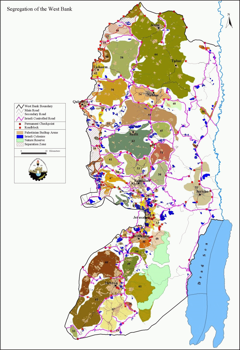
Beyond the immediate impact of this internal closure on Palestinian life in all West Bank districts, the areas in which the Israeli authorities have isolated Palestinians have far-reaching political implications. In an interview with Ariel Sharon by a Ha'aretz correspondent on April 12, 2001 the Prime Minister declared that he would relinquish only 42% of the West Bank for a future Palestinian state. He also declared a complete unwillingness to evacuate any Jewish settlements, the centerpiece of Israeli claims to the land. Says Sharon: 'It's not by accident that the settlements are located where they are. They safeguard the cradle of the Jewish people's birth and also provide strategic depth, which is vital to our existence. The settlements were established according to the conception that, come what may, we have to hold the western security area, which is adjacent to the Green Line, and the eastern security area along the Jordan River and the roads linking the two. And Jerusalem, of course. And the hill aquifer.'
The cumulative area of the 64 cantons in Figure 4 constitutes about 40% of the total West Bank area. If Sharon has his way, this area will correspond closely with that of any Palestinian 'state' recognized by Israel in the indefinite future. Such an arrangement would, in fact, eliminate the possibility of a viable state and leave the Palestinians in permanent subjectivity to Israel. The resulting Palestinian enclaves would be completely surrounded by Israel and movement from and between these areas dependent upon Israeli approval. Furthermore, what Sharon calls the western and eastern security areas, along with the hill aquifer, are the most fertile parts of the West Bank and the richest sources of water. This would leave the Palestinians with no basis for economic development.
During the period of July-September 2001, Sharon's government launched its new-old policy of unilateral segregation between the West Bank and the Israeli-controlled territories. Military orders were issued to seize a total of 224,000 Dunums from the northern districts, especially Jenin, Ramallah, Qalqiliya and Tulkarm. According to these military orders, isolated sectors along the 1949 Armistice Line (Green Line) were rendered closed military areas; i.e. no one was allowed to enter these areas without having a special permit issued by the Israeli authorities. See Figure 5.
Sharon's plan was more intensively implemented during the latest massive invasion in the West Bank, where most of the annexation of land to create military zones, concentrated around the Jerusalem boundaries. Thus, expanding the illegal boundaries of Jerusalem. Furthermore, on May 15th 2002, Israel announced a policy of dividing the West Bank into 8 besieged areas, where Palestinians will be forced to obtain special permits from the Israeli authorities to be able to move between these areas.
2.2 International law and Settlements
The entire world community (including the USA) recognizes the West Bank, Gaza Strip, and East Jerusalem as Occupied Territories. In fact, that's why almost all countries that recognize Israel do not have their embassies in Jerusalem, but rather, in Tel Aviv.
1949: The Fourth Geneva Convention, to which Israel is a signatory states 'the Occupying power shall not deport or transfer parts of its own civilian population into the territory it occupies'. However, Israel has declared that it is not bound to apply the Fourth Geneva Convention in the West Bank and Gaza but will be bound with its principles.
1967: UN Resolution 242 specifically emphasizes 'the inadmissibility of the acquisition of territory by war..
1980: UN Security Council Resolution 465
Determines that all measures taken by Israel to change the physical character, demographic composition, institutional structure or status of the Palestinian and other Arab territories occupied since 1967, including Jerusalem, or any part thereof, have no legal validity and that Israel's policy and practices of settling parts of its population and new immigrants in those territories constitute a flagrant violation of the Fourth Geneva Convention relative to the Protection of Civilian Persons in Time of War and also constitute a serious obstruction to achieving a comprehensive, just and lasting peace in the Middle East.
1998: The Rome Statute of the International Criminal Court defines 'the transfer directly or indirectly by the Occupying power of parts of its own civilian population into the territory it occupies' as a War Crime indictable by the International Criminal Court.
2001: The Mitchell Report stated 'A cessation of Palestinian-Israeli violence will be particularly hard to sustain unless the Government of Israel freezes all settlement activity. The Government of Israel should also give careful consideration to whether settlements that are the focal points for substantial friction are valuable bargaining chips for future negotiation or provocations likely to preclude the onset of productive talks.'
2.3 Colonization Policy and Facts:
As discussed above, since the signing of the Declaration of Principles in 1993, Israel has followed a policy of creating de facto realities on the ground to affect the outcome of the final status negotiations. Israel has accelerated its colonizing activities by confiscating more Palestinian land to establish new settlements on hilltops and build a comprehensive network of by-pass roads. These activities have been a main source of the instability in the peace negotiations between the government of Israel and the Palestinians.
According to Israeli data there are 140 settlements in the West Bank and Gaza, however satellite images show 310 built-up areas (Polygons) in the West Bank including East Jerusalem and 26 in Gaza. This is excluding military sites. These built-up areas cover 183.3 sq. km (GIS database, ARIJ, 2003). The discrepancy stems from the fact that Israeli sources consider those Jewish built-up areas in East Jerusalem as neighborhoods of the Israeli-defined Jerusalem municipality and not as settlements. Israel does not identify the new expansions of settlements as separate sites; however, in our sources these new expansions are treated as a new individual settlement by itself, for example, Talamon was expanded to various areas that are distant from the original settlement, according to Israeli sources, these sites are lumped in to one settlement i.e. Talamon, however, we refer to some of these areas as Talamon B and Talamon C. In another example, the settlement of Itamar in Nablus is divided into Itamar east 1, Itamar east 2, Itamar east 3 etc. This explains the discrepancy in the figures. Currently the total number of settlers in the West Bank and the Gaza Strip number around 415634 of which nearly 198332 are in East Jerusalem alone.
Table 3: Land Use in the West Bank
|
|
Area in km² |
Percent of the West Bank |
|
Palestinian built-up areas in the West Bank |
368.5 |
6.5 % |
|
Jewish settlements in the West Bank |
167.25 |
2.96 % |
|
Israeli Military Base |
37.9 |
0.7 % |
|
Closed Military Area + newly closed area |
1223.1 |
21.6 % |
|
Nature Reserves |
322.8 |
5.7 % |
|
Forests |
58.8 |
1.0% |
Source: Applied Research Institute, GIS Database, 2003
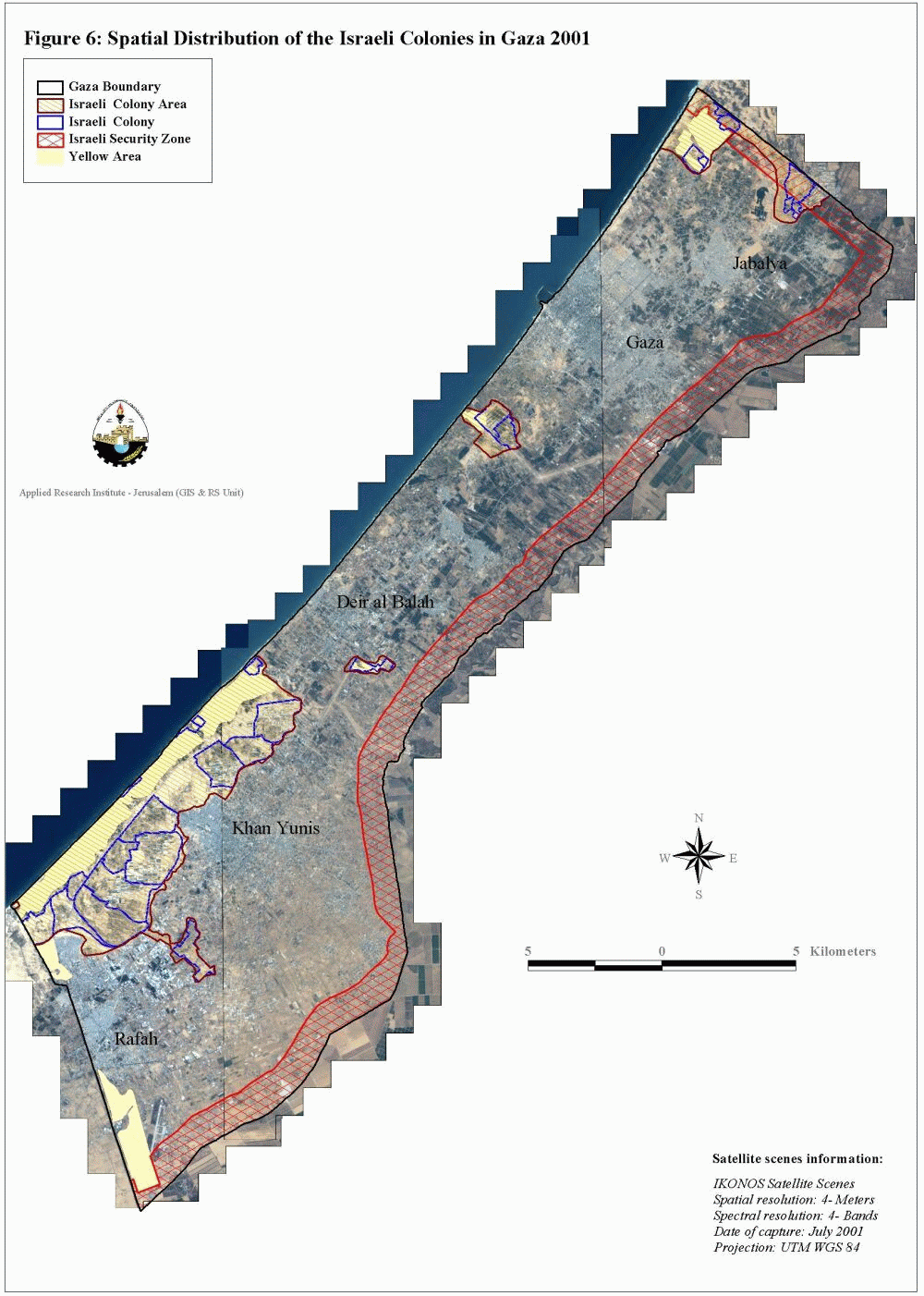
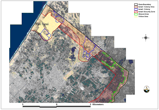
The preceding table shows how Israel managed, in 32 years of occupation, to confiscate and expropriate over 30% of the West Bank for exclusive Jewish use. In Gaza Strip, the total Israeli settlement area covers 53.8 km2 (14.8%) of the Gaza Strip, whereby 6,429 settlers live. See Figure 6
Jewish settlements are scattered all over the West Bank and lie predominantly to the south along the coast in the Gaza Strip. Successive Israeli governments have encouraged the development of specific blocks more than others. In the West Bank, the focus has been on the following areas:
1. The Jerusalem area to create demographic barricades in front of any Palestinian claims to it,
2. Along the West Bank's western edges so as to make the return to the 1967 borders practically impossible, and so as to make the settlements appealing to settlers, who commute to work inside Israel
3. The Jordan valley for its presumed importance to Israel's security as well as for its agricultural resources.
Furthermore, the growth of settlements is mainly geared to the formation of blocks; i.e. they grow outwards and towards each other. The end result of such a growth is the grouping of Palestinian towns and villages into three or four cantons. Indeed, the Israeli intention is to make the contiguity of any Palestinian State in the future practically unattainable.
The Labor and Likud Israeli governments have maintained progressive expansions of these settlements. To achieve this goal, they have confiscated Palestinian land, demolished their houses, and uprooted thousands of trees. Since the signing of the Declaration of Principles in 1993 and until December 2002, more than 260220.5 Dunums of land have been confiscated, 226441 trees have been uprooted and over 1305 houses demolished in the West Bank alone. At the Applied Research Institute-Jerusalem (ARIJ), the change in the size of West Bank settlements is monitored by satellite.
|
Year |
Settlement Area (sq. km) |
Percent of the West Bank |
|
1990 |
77.4 |
1.4% |
|
1996 |
103.9 |
1.8% |
|
2000 |
149.6 |
2.6% |
|
2001 |
154.7 |
2.7% |
|
2003 (January) |
167.25 |
2.96% |
Source: Applied Research Institute, GIS Database, 2003
In Gaza Strip, and through analyzing land use classifications within the settlements of the Gaza Strip, we were able to detect patterns of settlement expansion in the Gaza Strip. These land use classifications include new outposts as well as residential, agricultural, industrial and security areas.
Table 5: Areas controlled by Israel In Gaza Strip
|
Jewish settlement area |
53.7 Km2 |
|
Israeli settlement |
26.66 Km2 |
|
Israeli security zone |
58.03 Km2 |
|
Israeli Military Installation Areas |
15.8 Km2 |
|
Yellow Areas |
8.43 Km2 |
|
Buffer Zones (Shaved) |
2.42 Km2 |
Source: ARIJ Database, 2003
For detail land use classification and expansion in Israeli settlements in Gaza, see table 6 below.
Table 6: Land Use Classification and expansion in Israeli settlements in Gaza
Total area controlled by Israel in Gaza Strip is 165.02 km², which occupies 45.7% of Gaza's total area. The area controlled consists of Jewish settlement area including settlement built up areas, security zones, military installations, buffer zones and yellow areas. Such areas often overlap; therefore, the total area controlled (165.02 km2) is not the sum of the areas detailed in table 5.
Map 7: illustrates the overlap between Israeli areas in the Gaza Strip.
6429 Israeli settlers occupy 165.02 square kilometers, whereas 1,001,569 Palestinians.occupy the remaining 197 km² only. The Palestinian population density of 4471 persons/km2 is therefore 100 times greater than that of Jewish population density, which reaches 43-persons/ km2. Since the outbreak of Al-Aqsa Intifada, Israeli army launched massive operation of 'Shaving land ' in Gaza Strip Figure 8. Almost, 3.5 km2 of agricultural land have been bulldozed till December 2002. occupy the remaining 197 km² only. The Palestinian population density of 4471 persons/km2 is therefore 100 times greater than that of Jewish population density, which reaches 43-persons/ km2. Since the outbreak of Al-Aqsa Intifada, Israeli army launched massive operation of 'Shaving land ' in Gaza Strip.
Figure 8: shows the Shaving of land in Gaza Strip

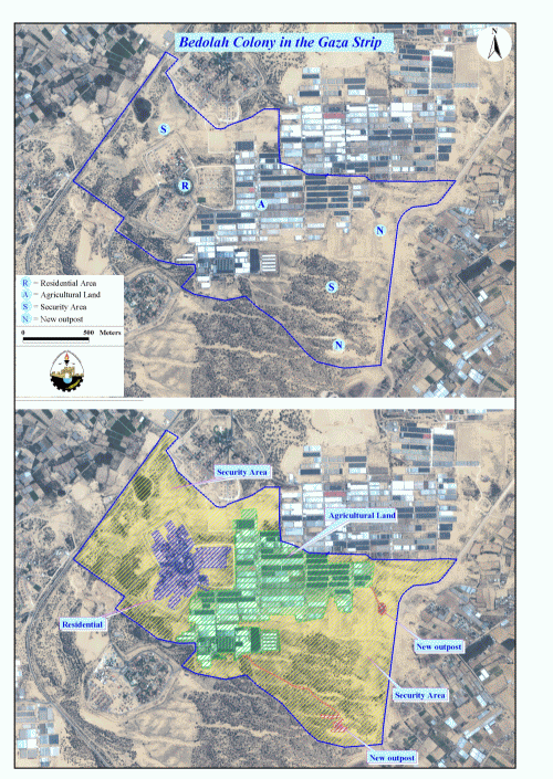
Figure 9 depicts the land use classifications in Israeli settlements of the Gaza Strip.
As shown in the figure, Bedolah settlement in Khan Yunis district is made up of four areas: security area shaded in yellow, agricultural area shaded in green, residential area shaded in blue and new outposts (expansions). Bedolah settlement including these areas constitutes 5.6% of the total Jewish settlement area.
2.4 Demographic Pattern of Israeli settlements:
The growth in settlements varied from one district to the other. Between 1992 and 2001 there was a remarkable increase in the settler population in Ramallah district (298% relative increase). This indicates that, after having focused on Jerusalem for many years (as noted before, there are as many settlers in Jerusalem as there are in the rest of the West Bank), the Israelis started enlarging the settlements in the adjacent districts especially Ramallah. It is worth mentioning here that the PNA's official districts was used in the following table to classify settlements' population growth. Table 7: Absolute and Relative Growth in settlements 1996 – 2001, by District
|
District |
Settlers 1992 |
Settlers 1996 |
Settlers 2001 (estimated) |
Absolute Growth (2001-1992) |
Relative Growth (1992-2001) |
|
Bethlehem |
40430 |
48312 |
63248 |
14936 |
37% |
|
Gaza |
3775 |
5266 |
7288 |
2022 |
54% |
|
Hebron |
9375 |
11578 |
14296 |
2718 |
29% |
|
Jenin |
1125 |
1421 |
1875 |
454 |
40% |
|
Jericho |
3965 |
4285 |
4929 |
644 |
16% |
|
Jerusalem |
136170 |
162887 |
195659 |
32772 |
24% |
|
Nablus |
4195 |
5441 |
8687 |
3246 |
77% |
|
Qalqiliya |
19250 |
22064 |
27940 |
5876 |
31% |
|
Ramallah |
11660 |
23121 |
54424 |
31303 |
268% |
|
Salfit |
16555 |
20420 |
25517 |
5097 |
31% |
|
Tubas |
725 |
852 |
1091 |
239 |
33% |
|
Tulkarm |
775 |
1272 |
2394 |
1122 |
145% . |
Source: ARIJ database 2002
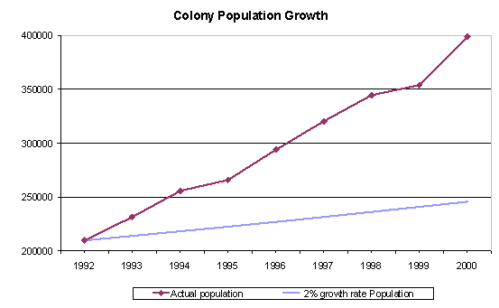
It is worth noting that there is a discrepancy between the average growth rate fore Jews in Israel and that in Jewish settlements. The average growth rate for Jews in Israel is 2.0% per year (the rate including non-Jews is 2.5% per year). However, the population of the Jewish settlements grows at around 8.5% per year, which amounts to over four times the Israeli growth rate. Between 1996-98 there were 130 settlements that had an average annual growth of over 2%. That means that over 80% of the settlements grow at rates higher than the overall Israeli average.
According to the Israeli Interior Ministry the settlers population in the West Bank excluding Jerusalem, grew by 8% last year (Average annual growth rate within the State of Israel is less than 2.5%, Israeli Abstract yearbook, 1999). Certain settlements continue to show huge growth rates, notably Betar Illit (24.6%) and Kiryat Sefer (28.1%). The following graph shows a comparison of growth rates.
Also, with the help of the Geographic information System unit (GIS) at the Applied Research Institute, 24 new settlements were shown constructed, and 113 new outposts composed of several caravans to be transformed later on into settlements. In Addition, 11128 dunums of land (11.128 Km2 area) were confiscated at favor of the new Israeli expansions in the West Bank during the year 2001-2002. The following table can summarize these activities in the Palestinian districts.
Table 8: Newly expanded Israeli settlement
|
District |
Newly expanded Israeli settlements |
New Israeli settlements |
New outpost (caravans) |
||||
|
No. |
Area in 2001 / dunums |
Area in 2002 / dunums |
Area of expansion / dunums |
No. |
Area in dunums |
No. |
|
|
Jenin |
3 |
820 |
1290 |
241 |
1 |
14.7 |
3 |
|
Tubas |
4 |
3354 |
5386 |
2032 |
– |
– |
1 |
|
Tulkarm |
1 |
385 |
526 |
141 |
– |
– |
7 |
|
Qalqilya |
7 |
3751 |
7.66 |
3315 |
1 |
36 |
5 |
|
Salfit |
14 |
11435 |
14415 |
2980 |
11 |
933 |
17 |
|
Nablus |
6 |
3888 |
4770 |
882 |
8 |
362.6 |
22 |
|
Jericho |
10 |
3615 |
4923 |
1308 |
3 |
422.3 |
20 |
|
Ramallah |
– |
|
|
|
– |
|
20 |
|
Jerusalem |
– |
|
|
|
– |
|
2 |
|
Bethlehem |
– |
|
|
|
– |
|
5 |
|
Hebron |
– |
|
|
|
– |
|
11 |
|
Total |
45 |
27248 |
38376 |
11128 |
24 |
1768.6 |
113 |
Source: Applied Research Institute, GIS Database, 2003
2.5 Bypass Roads
The term bypass roads came with the advent of the Oslo Accords and were not present before that. These roads are used by the Israelis to link settlements with each other and with Israel. In the agreements they are called 'Lateral Roads' but people usually call them 'bypass' roads because they are meant to circumvent (i.e. bypass) Palestinian built up areas. These roads are of course under Israeli control and entail a 50 to 75 meter buffer zone on each side of the road in which no construction is allowed.
The construction of by-pass roads commonly occurs along the perimeter of Palestinian built-up areas. As a result, these roads carve up the Palestinian areas into isolated ghettos and often deprive Palestinians of vital agricultural land. These practices have fragmented both land and people. This situation is very serious within the major cities of the West Bank where by-pass roads form asphalt boundaries that limit the expansion and development of the Palestinian communities, and further disconnect Palestinian communities from each other. Figure 10 marks those roads built by the Israelis since the Oslo Accords.
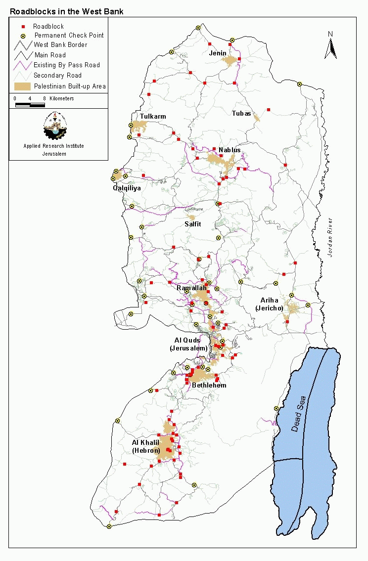
Figure 10
The construction of these by-pass roads requires the confiscation and destruction of approximately 87 km² of Palestinian land, most of which is agricultural. These bypass roads were constructed through a grant from the USA government in order to 'help' Israel in complying with the signed agreements and avoid friction between Jewish settlers and Palestinians. The role of the bypass roads became evident during the Intifada where they became the scissors that cut the Palestinian areas into 64 homelands in the West Bank and 3 homelands in Gaza. See figure 11
Figure 11
3. Statistical Analysis of Israeli Violations
The data that appear in the monthly, quarterly and comprehensive reports are collected from Palestinian and Israeli newspapers, satellite images, aerial photos, fieldworkers' reports, ARIJ and LRC verification and reports from other organizations. The reports that are received are divided up according to the agreed classifications. These classifications and their definitions are as follows:
|
C |
Construction; any increase in Israeli built-up areas |
|
D |
Demolition; any destruction of Palestinian assets |
|
E |
Expansion; any increase in land occupied by Israelis |
|
P |
Plans; plans issued for acts in any other category, or attempts at violations such as attempts at seizure. |
|
R |
Roads; any increase in the road network or changes in road blocks |
|
S |
Seizure; confiscation, eviction, occupation and any sort of asset grabbing |
|
U |
Uprooting trees |
Year 2002 witnessed an upsurge of Israeli violence in the Palestinian Territories; such violence included massive shelling, closure and reoccupation of various parts of the Palestinian areas. However, this report does not deal with data on such Israeli violations; therefore, demolition activities as compiled in this report do not cover data on the houses or infrastructure destroyed from shelling.
Incidents are categorized as to the district they occurred in. During the period of the project, the districts used are eight in the West Bank (Nablus, Jericho, Jenin, Jerusalem, Ramallah, Hebron, Bethlehem and Tulkarm) and the Gaza Strip. From February 2001, the PNA's districts were officially demarcated to include in addition to the above mentioned: Salfit, Tubas and Qalqiliya, as their borders had not yet been confirmed. However, this report continues to use the old classification of districts, so as to keep consistent with the data compilation of the first comprehensive report; this allows better comparison in the trends of Israeli colonization activities in each location of the Palestinian Territories.
3.1 Violations
3.1.1 Types of Violations
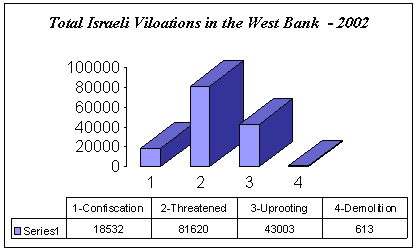
Since the eruption of the Intifada the Israeli government has been adopting the policy of house demolishing, Land Confiscation and Uprooting of trees as a collective punishment. There has been a considerable increase in the number of violations in the Occupied Territories. This rise can be seen from the average number of violations per month. In the West Bank, the largest category of incident this year has also been 'Uprooting trees' and vast areas of Land threatened to be confiscated. Chart 1 below shows a high indicator of those two types of violations.
Chart 1: Violations in the Occupied Territories during the year 2002
The Intifada has seen a particular upsurge in this incident with the army becoming renowned for uprooting large areas of land (particularly olive trees) under the pretext of security reasons and for confiscating land and destroy the lives and livelihoods of Palestinians under the usual pretenses in order to achieve long-standing goals of the Separation Wall or the so called the Apartheid Wall. It is an indivisible part of the closure and siege policy of the occupation, and is a continuation or 'advancement' of these policy; it is also unique in that it is a clear, widely-supported (both in its Israeli domestic approval and international complicity) mechanism (a Wall) used by Israel to confiscate and destroy massive amounts of land (some 10% of the West Bank) and devastate the lives of hundreds of thousands of people.
Chart 2: Palestinian lands confiscated in the West Bank by the Israeli authorities during the year 2002 in dunums
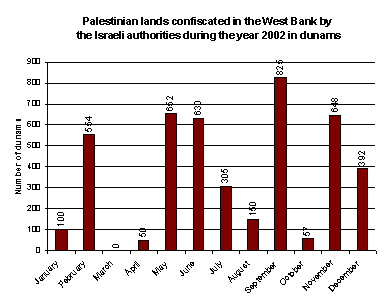
The Israeli attack on Palestinian lands to build the so-called Separation Wall is not based on security reasons only, as the Israeli media and government are claiming. Their plan besides the checkpoints, roadblocks and other physical barriers found in the West Bank, separates Palestinian localities from each other and results in the hampering or complete freezing of the economic, political, educational, medical, and social service activities necessary for a healthy society. Not also vast areas are threatened to be confiscated, but also areas containing artesian wells and main water basins that provides the west bank with water are also threatened to be lost at favor of this Separation Wall.
Also, the implementation of demolition campaigns at favor of the Separation Wall in the West Bank, specially those villages located near the green line will cause a real disaster for the people living in them, and will also kill their active economical situations. The Israeli policy behind such actions is to reduce as much possible the number of Palestinian citizens living in the areas located between the Green Line and the Separation Wall. Vast areas shall be illegally annexed to Israel from the Occupied Palestinian Territories and a large number of houses are going to be demolished or already had been demolished, which is a unilateral step of Separation and a sharp reduction in the number of Palestinians living on those areas. Chart 3 below shows the number of houses demolished and trees uprooted in the West Bank during the year 2002.
Chart 3

3.2 Districts
As mentioned in the introduction, the incidents events in the West Bank are categorized according to the district in which they occur. Eight district divisions were used. By counting the number of incidents occurring in each district we can locate which areas suffered most from these kinds of incidents;
Chart 4: Violations by District during the year 2002
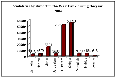
Chart 4 shows the values of the total number of violations in each district in the West Bank. This includes Land confiscated, Land Threatened to be confiscated, Uprooted trees and house demolition. Qalqiliya experienced the largest number of violations at 55698. Tulkarm and Jenin were the next worst affected with 52171,15601 violations incidents respectively. In the same time, the overall incidents in Gaza strip districts are 383
chart 5:Violations concerning uprooting of trees during the year 2002

Chart 5, shows in details the violations concerning uprooting of trees in each district. Almost 26261 trees were uprooted in Qaliqliya district, as well as Jenin, Nablus and Ramallah witnessed the largest number of violations at 6305,3730 and 3402 respectively.
During the year 2002, the Israeli occupation authorities escalated their acts of forced eviction, seizure, demolition and closure of Palestinian structures. Jenin district was notably affected by the demolition Campaign as shown in Chart 6.
Chart 6: Violations concerning House Demolition in the West Bank -2002

Such a high number of demolition incidents (238) are due to the Israeli incursion to Jenin camp in April 2002. Jerusalem district was largely affected by the Israeli campaign of House Demolition, where Jerusalem residents are subjected to discriminatory policies, particularly in their rights of residence and construction. Such policies fall under a larger Israeli occupation plan to restrain Palestinian demographic growth in Jerusalem.
3.3 Villages
Certain villages, like certain districts are more severely affected by Israeli violations than others; In Qalqiliya district, located to the northwest of the West Bank .See Map.
Since the year 1948 the district of Qalqiliya is facing the problem of land confiscation and colonization because of it's proximity to the 1948 Armistice line. The district today is surrounded by 15 Jewish settlements. Today Qalqiliya is facing a dangerous Israeli project as well as other districts in the West Bank, which is the 'Separation Wall'. This project will make the district a real prison and deprive it from most of its natural resources that are mainly water and land.
Before Al-Aqsa Intifada, the percentage of employed persons in Israel reached 28.1% of the total employment in Qalqiliya district, while persons employed in Agriculture reached 16.5%, trade 13.3 %, and the rest for industry, education, public administration and other services. See Table-1.
Table-1: Distribution of Labor Force by economic activity
|
Type of employment |
% Of Employment Before Al-Aqsa Intifada |
|
Construction (mainly in Israel) |
28.1 |
|
Agriculture |
16.5 |
|
Trade & commerce |
13.3 |
|
Industry & manufacturing |
14.0 |
|
Education and public administration |
15.9 |
|
Other services |
12.2 |
Source: PCBS-1999/2000
After Al-Aqsa Intifada, the number of Palestinians working in Israel declined extensively because of the Israeli closure policy, and most of the construction workers (70%) went to work in agriculture. The total number of labour force is 45,906 persons, with unemployment rate of 70%, as mentioned above, the number of employed persons is therefore 14,098. The daily Israeli violations such as uprooting of trees, shaving of lands and land confiscation, reduced the number of cultivated land to the half, because the farmers are not able to attain new debts or loans while they are loosing their capital which is the land. The percentage of unemployment in Qalqiliya district till the year 2000 was 16.1%, (PCBS) while during the year 2002 the percentage of unemployment reached 70 % according to the workers Union in Qalqiliya.
According to estimates released on May 7th, 2002 by the United Nations Development Program (UNDP), Israeli incursions in Palestinian towns in the West Bank have caused severe economic damages. The total damage in the West Bank could range between $300 million and $400 million. The agency said that Qalqiliya suffered some $3.5 million worth of damage. See Table 2: Total Israeli Violations in Qalqiliya District during the year 2002
|
Year |
Land confiscated (Dunums) |
Land threatened (Dunums) |
Uprooted trees |
|
2000 |
0 |
1995 |
1690 |
|
2001 |
200 |
1783 |
17204 |
|
2002 |
10305 |
21,125 |
25861 |
|
Total |
10505 |
24,903 |
44755 |
Source: ARIJ GIS database 2003
3.3.1 Recent Israeli activities in Jayyus village:
Jayyus village is located 2 Km to the eastern side of the 1948 border, with a total area of 13,000 dunums and a population of 3000. The settlement of Zufin is located to the west of Jayyus since the beginning of 90's; also an Israeli quarry is working in the same area since 5 years. The area shared between Qalqiliya city, Falameh and Jayyus is containing 7 artesian wells, for that reason in addition to its proximity to the green line, large areas of land will be confiscated for the Separation Wall plan.
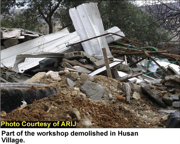
The lands of Jayyus village are divided into 20 Blocks, so it can be said that the majority of lands, belonging to the village, fall under the threatened areas and even the violated areas. The people of Jayyus as well as those of other villages are always having problems with the Israeli occupation forces in order to stop these violations but the Israeli soldiers are using the force and sometimes the excessive force to keep the people away from their lands, See Photos 1 & Photo 2
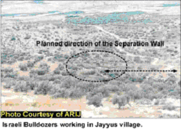
Photo 1
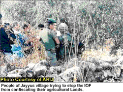
Photo 2
3.3.2 Recent Israeli activities in Falameh village:
Falameh village is located to the eastern side of the green line, to the west of Kafr Jammal and to the northwest of Jayyus villages. For the fact that Falameh village is too close to the green line, it is really threatened to be partially annexed to Israel.
Falameh is going to loose 1,700 dunums from its lands, in addition to 840 dunums that are where the wall will pass through. See Photo 3 & Photo 4
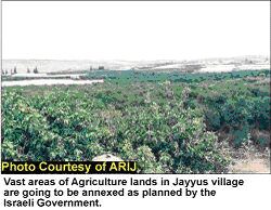
Photo 3
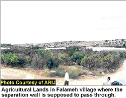
Photo 4
4. The Separation Wall.
The new plan that the Israeli government is applying nowadays is the construction of the Separation Wall. This wall will try to isolate Palestinian territories from Israel. Through constructing the Separation Wall, the Israeli government is annexing and confiscating areas from the West Bank including as maximum as Palestinian lands, illegal settlements and water resources to Israel. This plan, according to Israeli maps published by the Israeli occupation forces, will cost the people of Qalqiliya around 35.2 Km2of their land so this means 20.2% of the total area of Qalqiliya district. See map above.
This wall will swallow many lands and isolate the district, transforming it into prison camps. Artesian wells that will be included within the wall will be 15, and this means 20.8% of the total number of wells in the district.
Table -1
|
|
Original |
To be annexed |
Percent of annexation |
|
Area |
174.0 Km2 |
35.2 Km2 |
20.2 % |
|
Artesian wells |
72 wells |
15 wells |
20.8 % |
Source: ARIJ- GIS-Database 2003
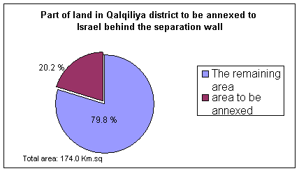
Table-2: Total agricultural area annexed for the security zone in Qalqiliya district:
|
Crop |
Total agricultural area annexed in Dunums |
|
Field Crops |
393 |
|
Olive trees |
1533 |
|
Orchard |
3261 |
|
Vineyard |
252 |
|
Total |
5,441 |
Source: ARIJ-GIS-Database-2002
Table-3
|
Total agricultural area in Qalqiliya district /Dunums |
Agricultural area annexed (Dunums) |
Agricultural area annexed |
|
*69352 |
**5441 |
7.84% |
* PCBS-1999/2000
** ARIJ GIS Database- 2002
Summary:
The total area of Qalqiliya district is 174.0 Km2, and the Separation Wall will nibble 35.2 Km2, which represents 20.2% of the total area. The agricultural sector is going to loose 5,441 dunums (5.44 Km2), which means 7.84 % of the total agricultural lands in the district. Fifteen important artesian wells, mostly used for irrigation, are going to annexed from Qalqiliya according to the Israeli segregation plan, 8 of them are located between Falameh and Jayyus and are among the most threatened wells. The total number of uprooted trees till December 2002 was 26261 trees. The percentage of unemployment in the district reached up to 70% during the year 2002, while during the Israeli military incursions, Qalqiliya district suffered some $3.5 million worth of damage according to estimates released on May 7th, 2002 by the UNDP.
5. Recent Colonizing Activities in the West Bank during the year 2002
1-Bethlehem: February 2002
The Israeli government commenced the construction of a new 'bypass road' southeast Bethlehem district. The road will be constructed over Palestinian lands of Beit Sahour, Bethlehem, Za'atra, Ras-El Wad, Tekoa, Al-Shwawreh and Al-Fureidis villages. Military order number 02/02/C was issued by Yitshak Etan, the IDF commander in the occupied territories, and stated that the land was seized for military use. The following data collected from both Satellite image and fieldworkers:
|
Road length |
5.5 Km |
|
Asphalt area |
90 dunums |
|
Total area, including security buffer zone (to be confiscated) |
740 dunums |
Source: Applied Research Institute, GIS Database, 2003
2-Bethelhem: May 2002
The Israeli government continues its work to establish a new separation zone to the north of Bethlehem district. This security zone will result in the annexation of 15 Km2of total area of Bethlehem district. The new military road will be connected to Road 60 from the west and with Abu Ghniem settlement from the east. The table below clarifies the data collected from both fieldwork and satellite image analysis. Table 2
|
Total length of the fenced military road |
Total |
Existing |
Planned |
|
14.5 |
11 Km |
3.5 Km |
|
|
Total aggravated area |
0.29 Km2 |
||
|
Total area to be annexed (inaccessible to Palestinian) from Bethlehem district* |
15 Km2 (i.e.2.5% of Bethlehem district area) |
||
Source: Applied Research Institute, GIS Database, 2003
3-Jerusalem: May 2002
A bid to construct 957 housing units was issued by the Israeli Ministry of Housing. Those housing units will be concentrated on settlements around Jerusalem as follow: Table 3
|
Settlement name |
Number of units |
|
Givat Hazeit |
339 |
|
Betar Illit |
244 |
|
Maale Adummim |
244 |
|
Givat Benyamin (Adam) |
76 |
|
Har Adar |
74 |
Source: Applied Research Institute, GIS Database, 2003
4-Jerusalem: June 2002
The Israeli authorities, under the protection of Israeli police, began the first stage of establishing a new settlement called 'Nof zahaav'. The new settlement will be established on 114 dunums of the Palestinian neighbourhood Jabal Al Mukkaber, to the East of Jerusalem.
5-Jerusalem: June 2002
The Israeli Ministry of Housing ratified the decision to expand Givat Ha Matos settlement established on Palestinian lands of Beit Safafa village, southwest Jerusalem. Almost 1000 dunums of land were confiscated at favour of constructing new 4200 housing units with a total population of 25,000 new settlers. The plan also includes the construction of nine hotels opposite to mar Elias Monastery. It is believed that this expansion will lead to the establishment of a new settlement called Givat Ha arba.
A house demolition campaign in Al Isawiya village. The residents of Al Isawiya woke up in the morning of 14/1/2002 at the noisy sound of huge bulldozers surrounding the village from all its entrances. They demolished 9 houses (13 apartments) and belong to 13 families in the area. More than 78 people became homeless as a result of this demolition campaign.
6- West Bank (June 2002)
Contrary to worldwide news reports, the Apartheid Wall (also referred to as the 'fence' or 'security fence'), which Israel is currently building in the northeast of the West Bank, will not mark the 1967 border (also known as the 'Green Line'). Rather, amidst some of the most fertile land in Palestine, this latest unilateral offensive will be a further exercise to Israel's annexation of agricultural lands, destruction of property, and violation of human rights.
In the northern West Bank, the first phase of the Apartheid Wall is to be approximately 115km long and is to include electric fences, trenches, cameras, sensors, and security patrols, at a cost tens of millions of dollars. The height of the Apartheid Wall will average 8 meters (25 feet) and in its entirety is to cover at least 350km, somewhat encircling the West Bank. In this first phase, which will see the confiscation of close to 2% of the West Bank, while at least 30 villages will loose parts or all of their lands. In an area 40 kilometers north of Qalqiliya, approximately 90,000 dunums (90 km square) will be lost as a consequence of about 12% of the length of the Apartheid Wall. The first phase in its entirety is expected to see of about 12% of the length of the Apartheid Wall. The first phase in its entirety is expected to see the confiscation of between 160,000-180,000 dunums. The built-up (residential) areas of at least 15 villages will be east of the Apartheid Wall, while a significant portion of their lands will be either inside the Apartheid Wall or on the other side. In addition, the city of Qalqiliya, which is the urban center for the entire area, will almost be completely encircled by the Apartheid Wall.
According to the Campaign map, the following 15 villages will be trapped between the Apartheid Wall and the Green Line, in closed military areas: Khirbet Um Al Rihan, Barta'a Al Sharqiya, Dhaher Al Malih, Khirbet Abdallah Al Younis, Khirbet Al Sheikh Sa'eed, Khirbet Al Muntar Al Gharbiya, Nazlat 'Isa, Nazlat Abu Nar, Baqa Al Sharqiya, Khirbet Jubara,'Arab Al Ramadin Al Shamali, 'Izbat Jal'ud, Al Dab'a, 'Arab Al Ramadin Al Janubi, and 'Arab Abu Farda. It is expected that Rummana, Ta'anak, Khirbet Al Tayba, Al Sa'ida, and Anin will eventually be included between the Wall and the Green Line in the first phase as well. The fact that Israel has repeatedly changed the route of the Wall is a major factor in the changing estimates and reality.
During the Intifada, various Israeli governmental discussions around the building of the Apartheid Wall took place, perhaps somewhat casually, amidst the various other unilateral decisions taking place by Israel on behalf of the Palestinians. In April 2002, an order by the steering committee/cabinet dealing with the Apartheid Wall called for the immediate commencement of the Apartheid Wall in the northern West Bank and the Jerusalem area. In a further institutionalization of the Apartheid Wall, the committee created a 'Seam Area Administration' that would implement the decision, according to a report produced by B'tselem, an Israeli human rights organization. Only days later, and before any publication of a map determining the route of the Apartheid Wall, the Israeli military confiscated land in the northern West Bank and began to uproot trees.
Governmental-ministerial meetings concerning the Apartheid Wall continued, when in August, following objections within the Israeli security establishment to the first maps of the Apartheid Wall, changes were made but were never published. For months following the commencement of the Apartheid Wall, the government and military never made available to the public its plans, and only after continued demands by Palestinian human rights organizations to produce the map, was the first phase made available. Changes to the map, and the complete map of the Apartheid Wall, existed without any outside knowledge. According to the Palestinian human rights organization LAW, the map presented by the military to the Israeli High Court in September were different from the maps they presented in October specifically for the area of Qalqiliya, noting that an additional 1,000 individuals would be in the area between the Apartheid Wall and Israel. The changes to the map were done without public knowledge and without warning. Nevertheless, military orders for land confiscation continue unabated.
B'tselem concurs in September, 2002, report on the Apartheid Wall, that the map they produced for the first phase of the Apartheid Wall was based not on an Israeli, official military map. Rather, they based their map on the military orders of land confiscation (which they could infer from where the Apartheid Wall would be located) as well as a list of Israeli settlements to be situated west of the Apartheid Wall, as published by the Israeli media. The settlements B'tselem refers to are Shaqed, Hinanit, Tal-Menashe, Rehan, Sal'it, Tzufim, Alfe Menashe, Oranit, Sha'are Tiqwa, and Elqana, all of which will be annexed to Israel, enjoying the full rights of Israeli citizens, unlike those Palestinians in the same annexed areas.
In the beginning of September, the cabinet also approved including Rachel's Tomb within the Apartheid Wall's borders, which is located inside Bethlehem. Land confiscation and tree uprooting has commenced for the Apartheid Wall in the Bethlehem area as well.
It cannot be emphasized enough the fertility of the land that has been confiscated in the north and is being destroyed, also taking into consideration the continued poverty due to forcible closure by Israel on the Palestinians, translating into the fact that people's sustenance and survival depends on these lands. Approximately 30 groundwater wells in the first phase of the Apartheid Wall will be out of bounds, having been separated by the Apartheid Wall from the villages depending on them, meaning even further Israeli control over Palestinian water resources. For a number of villages, they will loose their only source of water.
As the southern portion of the Apartheid Wall is as of yet unclear, so is the central or Jerusalem portion of the Apartheid Wall. What is known is that the Apartheid Wall will allow for a furthering of Israel's establishing facts on the ground in the Jerusalem area. Repeated public confirmations by numerous Israeli government officials confirms that the Apartheid Wall will in no way mark the 1967 border and will not threaten Israel's control over the occupied city. Taking into consideration that approximately 50% of the Israeli-Jewish settlers in the West Bank are East Jerusalem settlers, including the settlements built in the outskirts of Jerusalem, it is expected that the Jerusalem portion of the Apartheid Wall will represent a large portion of the lands confiscated for the Apartheid Wall, including the annexation of at least 15 settlements. In addition, Israel's continued pursuit to ensure a Jewish majority means that a number of Palestinian neighborhoods in the outskirt of Jerusalem, which it continues to deny the right of territorial continuity with the West Bank through the establishment of checkpoints, will be placed in a limbo like the other areas between the Apartheid Wall and Israel in the north.
The reference in the international media to a 'fence' being placed to separate the 'two sides' should be seen more as a cynical, unrepresentative use of terms than any real reflection of the Apartheid Wall itself, both its massive physical structure (8 meters high) and its implications on the lives of hundreds of thousands of people. The separation rhetoric, which should remind everyone of the Afrikaans word for separation- Apartheid -is not a reflection of real geographic or a historic physical divide between two peoples, but rather is reference to Israel's continued campaign of forcible, unilateral separation and expulsion plans that disregard national or economic sovereignty for Palestinians. The Apartheid Wall just furthers the 'Cantonization' of the West Bank into hundreds of small, dependent entities that cannot sustain themselves and that are more akin to small, disconnected open-air prisons surrounded by Israeli military checkpoints and settlements, than anything else.
In order to pinpoint the start of the building of the Apartheid Wall, one must have an understanding of the Occupation itself, within which the Apartheid Wall is a means, and an acceleration of long-established began most recently in 1967, with the most recent wave of closure and restriction can be seen with the commencement of the closure policy in the mid-90s. Israel's security rhetoric that revolved around closure and severe restriction to movement is some ten years old and is part of the justification it uses to erect the Apartheid Wall. Unilateral barriers are not new, but their size and magnitude grow. See Map 1
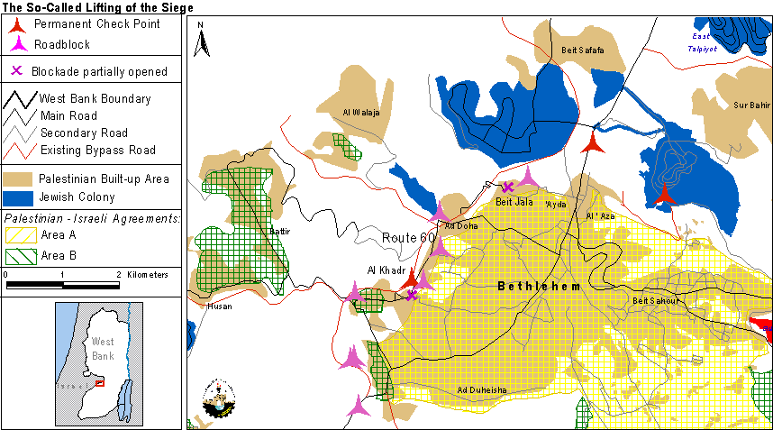
7-Bethlehem (September 2002):
On September 11th 2002, the Israeli security cabinet approved the Jerusalem security closure line plan and the recommendation of the prime minister Arial Sharon to include Rachel's Tomb, in the north of Bethlehem District and along side the Jerusalem boundaries. Rachel's Tomb is situated on the outskirts of the West Bank city of Bethlehem and is located in area C, under the Israeli control.
The proposed plan includes:
The construction of a one-kilometer length road, which will link Rachel's tomb with road 60, more than 20 dunums of land, will be confiscated to construct this road.
The construction of 10 meters-high walls, which will circulate the Tomb and runs alongside the road.
8- Bethlehem (September 2002):
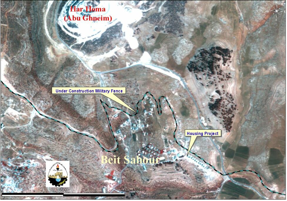
In the early 1990s, the Israeli authorities wanted to expropriate part of the Orthodox Patriarchate land for the establishment of the settlement of Abu Ghneim (Har Homa). In order to preempt the Israeli move, the directors of the Greek Orthodox Housing Project requested the Orthodox Church in 1995 to give them a plot of land adjacent to Abu Ghneim Mountain. The aim of the project is to help the limited income households in Beit Sahour community and to prevent the confiscation of more lands from the city. Till now, 8 buildings of the total 15 buildings that contain 120 housing units were constructed and a number of 20 families are currently living there. See Photo

In 1997, the Israelis started to shave and uproot the trees of the only Palestinian forest (Abu Ghnim ), in order to construct the new settlement of Harhoma.
In April 2002, the Israeli military forces visited the area and handed the residents an order of terminating building constructions under the pretext of not having building permits from the Israeli administration of Beit Il in Ramallah, considering the area under their control (Area C) which means ' no construction is allowed on it' and sorestricting Palestinian constructions and preventing the expansion of Palestinian communities located in the vicinity of Harhoma settlement. This termination came parallel to the construction of the separation wall that was opposed by the Israeli Government. The housing project is still opposing the separation wall plan endorsed by the Israeli Prime Minister Ariel Sharon and the erecting of the new military road that will be connected to it from Road 60 to the west with Abu Ghneim . See Satellite Image.
9-West Bank: October 2002
The Applied Research Institute-Jerusalem (ARIJ) with the help of the Geographic information System unit (GIS) showed that 24 new settlements were constructed, and 113 new outposts composed of several caravans to be transformed later on into settlements. In Addition, 11128 dunums of land (11.128 Km2 area) were confiscated at favor of the new Israeli expansions in the West Bank during the year 2001-2002. The following table can summarize these activities in the Palestinian districts. See Table below: Newly expanded Israeli settlements
|
District |
Newly expanded Israeli settlements |
New Israeli settlements |
New outpost (caravans) |
||||
|
No. |
Area in 2001 / dunums |
Area in 2002 / dunums |
Area of expansion / dunums |
No. |
Area in dunums |
No. |
|
|
Jenin |
3 |
820 |
1290 |
241 |
1 |
14.7 |
3 |
|
Tubas |
4 |
3354 |
5386 |
2032 |
– |
– |
1 |
|
Tulkarm |
1 |
385 |
526 |
141 |
– |
– |
7 |
|
Qalqiliya |
7 |
3751 |
7.66 |
3315 |
1 |
36 |
5 |
|
Salfit |
14 |
11435 |
14415 |
2980 |
11 |
933 |
17 |
|
Nablus |
6 |
3888 |
4770 |
882 |
8 |
362.6 |
22 |
|
Jericho |
10 |
3615 |
4923 |
1308 |
3 |
422.3 |
20 |
|
Ramallah |
– |
|
|
|
– |
|
20 |
|
Jerusalem |
– |
|
|
|
– |
|
2 |
|
Bethlehem |
– |
|
|
|
– |
|
5 |
|
Hebron |
– |
|
|
|
– |
|
11 |
|
Total |
45 |
27248 |
38376 |
11128 |
24 |
1768.6 |
113 |
Source: Applied Research Institute, GIS Database, 2003
11- Hebron: November 2002
Since September 28,2000, Hebron City has been totally blockaded; all the entrances have been closed by concrete blocks and checkpoints that completely isolated area H1 (Municipal area transferred to Palestinian Authority) from the district villages. The Palestinian residents of area H2 (Municipal area remaining under Israeli rule) have been living under some of the worst conditions in the Palestinian territories. They have been under curfew, with no connection to other parts of the city. Many people have been killed and hundreds injured. People have suffered water cuts and electricity blackouts, 32 schools have been closed and four are being occupied by Israeli soldiers and converted into military bases. This restriction has hindered the ability of Palestinians in Hebron city to enjoy the right to live an ordinary life and resulted in the hampering or freezing their daily activities, which causes a lot of frustration and despair.
In November 15,2002, Israeli Prime minister Ariel Sharon and Defense minister Shual Mofaz announced a decision to carry out a new IDF military operation in Hebron in an attempt to bolster the settlements, mainly in Hebron, to protect the Jewish settlers in ' Kiryat Arba' ' settlement. In addition, they also declared the non-validity of 1997 agreement between the late Israeli Prime Minister Nitenyaho and President Yaser Arafat.
As a response to this Israeli decision, the Israeli forces handed military orders to families living in the area to demolish their houses in order to establish a 300 meters promenade with 3 meters high concrete walls erected on each side on the existing road leading to Ibrahimi Mosque. A new road with a length of 400 meters is under construction in order to link this promenade with Kiryat Arba' settlement. Thus linking the settlement with the Jewish neighborhood located at Hebron city center, which according to the Israeli Government will reinforce the safety of the Jewish settlers and eliminate the Palestinian presence in the old city of Hebron. As a result 44 houses are threatened to be demolished and thus more families become homeless. See Map
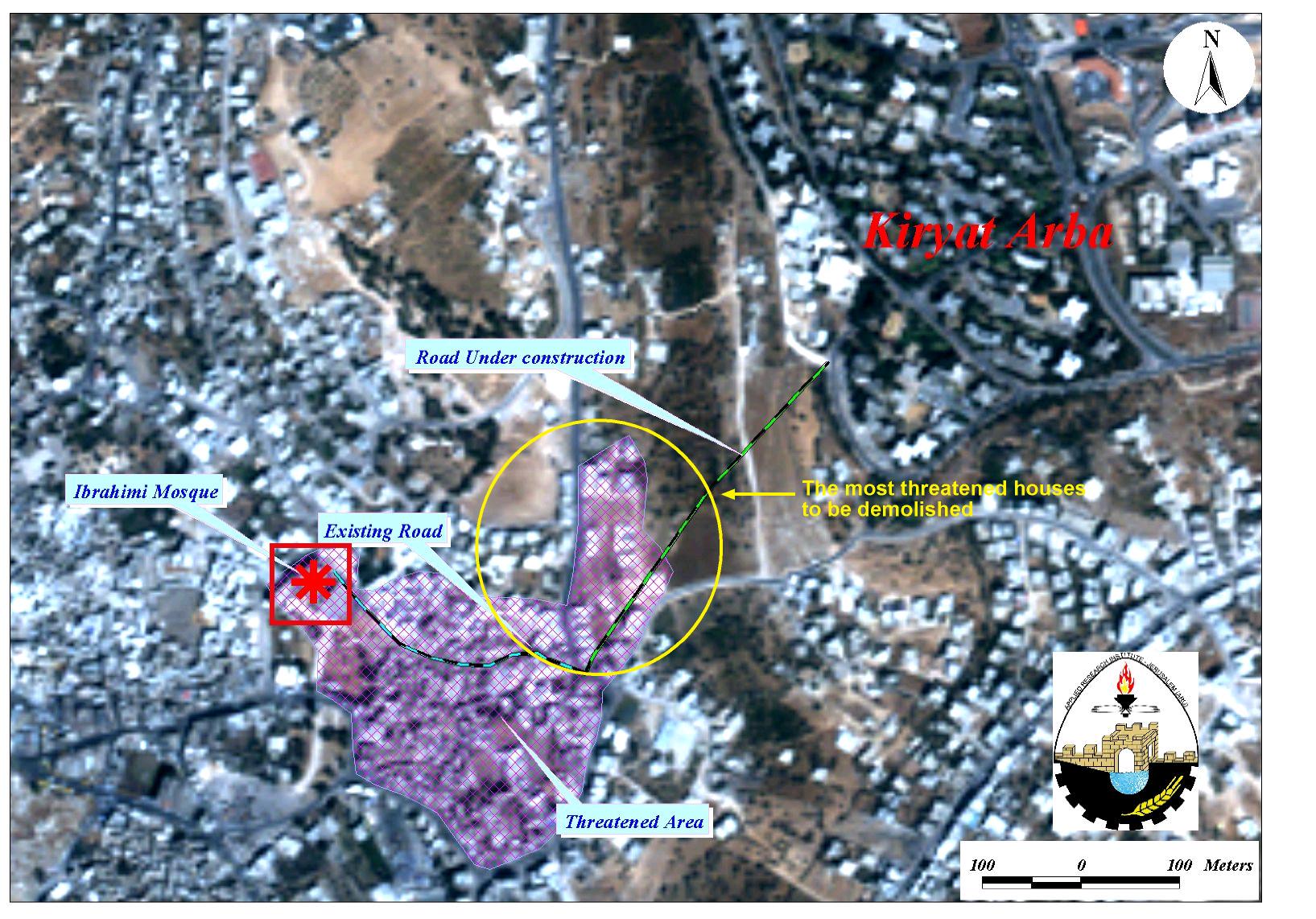
The presence of Israeli settlers and soldiers in Hebron is a source of constant suffering for Palestinians reside there and as a result, they live in extraordinary conditions that disrupt their daily lives in ways that make peaceful coexistence practically unattainable. The Hebron district is only one case in point illustrating the threat posed to the viability of a future Palestinian State by isolating the Palestinian communities from each other.
12-West Bank: December 2002
The Israeli budget: a pocket money for the settlements in West Bank and Gaza strip..
The Israeli government is devoting NIS 1.9 billion from its budget for the settlements in the occupied territories of West Bank and Gaza strip for the year 2003. This budget is considered to be as a financial incentive for settlers who intend to live in settlements located in Palestinian territories. On the 18th of December 2002, the Israeli government approved the budget after long weeks of discussion.
The Keren Kayemeth Leisrael KKL-JNF, which is a part of the Jewish National Fund, is providing 172.4 million NIS (new Israeli Shekels) for the seizure of lands in the West Bank and Gaza Strip.
The Ministry of Transportation will use NIS 253.5 million from Israeli taxes to pave roads and to open a new tunnel under the mount Scopus in Jerusalem with a cost of 35million NIS.
The Ministry of Defense will take the responsibility of opening new bypass roads with a cost of NIS 228 million.
The Ministry of Commerce & Industry will provide NIS 22.3 million up to NIS 51.9 million for this sector in the settlements of West Bank and Gaza Strip.
The Ministry of Housing is providing the settlements with NIS 350 million, while 31.3 million of them will be used for the enlargement of Maale Adumim settlement in East Jerusalem. Also the ministry is paying NIS 20.6 million for the protection of those settlers who are living in the neighborhoods of the old city in East Jerusalem. In addition, the ministry is giving NIS 76.8 thousand as loans for each person who wants to buy a new apartment where, 16.8 thousand shekels among these are granted.
The Ministry of Agriculture is participating with NIS 137.8 million for settlements.
The Ministry of Religion is giving NIS 50 million, which represents 30 % of its budget, for the building of Synagogues and religious institutions in these settlements.
The Ministry of Education is offering the free education for children by the age of 4 years until finishing high school, in addition to privileges provided for the teachers working in the settlements schools; such as scholarships at the university to upgrade their diplomas and levels of higher education, which will cost the ministry NIS 30 million.
The Ministry of Infra Structure is providing NIS 9.7 million for water projects.
The Ministry of Interior is offering NIS 480 million for the small settlements and localities, with the privilege of recuperating half million shekels of taxes each year.
The previously mentioned data is the official budget declared by the Israeli government, but the settlements are receiving financial aid also from other Jewish foundations or associations in addition to hidden parts in the budget that support the settlements indirectly.
6. Conclusion
It is important to recall here that United Nations Security Council Resolutions 242 and 338 ' emphasize the inadmissibility of the acquisition of territory by war and the need to work for a just and lasting peace in which every State in the area can live in security and affirms that the fulfillment of Charter principles requires the establishment of a just and lasting peace in the Middle East which should include the application of both the following principles:
1. Withdrawal of Israeli armed forces from territories occupied in the recent conflict; Termination of all claims or states of belligerency and respect for and acknowledgement of the sovereignty, territorial integrity and political independence of every State in the area and their right to live in peace within secure and recognized boundaries free from threats or acts of force;'
These resolutions also ' affirm further the necessity for achieving a just settlement of the refugee problem; and requests the Secretary General to promote agreement and assist efforts to achieve a peaceful and accepted settlement in accordance with the provisions and principles in this resolution;'
All Israeli settlements in the West Bank and Gaza are illegal according to International Law. Article 49 of the Fourth Geneva Convention specifically states that: 'The Occupying Power shall not deport or transfer parts of its own civilian population into the territory it occupies'.
For the Palestinians, 'Madrid' and 'Oslo' heralded the prospect of a State, and guaranteed an end to the occupation and a resolution of outstanding matters within an agreed time frame. Palestinians are frustrated at the continued growth of settlements and at their daily experiences of humiliation and disruption as a result of Israel's presence in the Palestinian territories. Palestinians see settlers and settlements in their midst not only as violating the spirit of all agreements ratified by both sides, but also as an application of force in the form of Israel's overwhelming military superiority, which sustains and protects the settlements.
Furthermore, the ongoing fragmentation of Palestinian land and communities into disconnected cantons combined with the frequent collective punishment of closures, house demolitions, withdrawal of identification cards, the confiscation of private property will and the military bombardment of the past year impose a physically unsustainable situation.
Any resolution to the conflict should not take into consideration the facts that Israel has illegally created on the ground (as they are always manipulated by Israeli colonization and occupation policies) but should take into account justice as a premise for sustainable peace. It is becoming clear that the solution for the conflict requires the dismantlement of all settlements as well as the displacement of the settlers without any exception, including what the Israeli government alludes to as 'neighborhood'. This is not unrealistic, unthinkable but inevitable. Israel can easily absorb the 400,000 settlers inside Israel. As a matter of principle, Israel should not be allowed to get away with its defiance of the international legitimacy and thus, the American attempt to consolidate the settlements will not be acceptable to Palestinians.
Prepared by:
The Applied Research Institute – Jerusalem