1. Introduction:
Bethlehem district has been a target of massive Israeli colonization activities due to Bethlehem's proximity from Jerusalem. Through confiscation of land and the construction of settlements, by pass and military roads around the boundaries of Bethlehem district, Israel managed to totally separate the district from Jerusalem as well as expand the illegal boundaries of Jerusalem.
Besides successive Israeli incursions into the district and the violations perpetrated against its residents, Israel has recently launched another serious, yet partially visible violation in the district, that of colonization. In the past few weeks, Israeli colonization activities in Bethlehem district drastically propped up exacerbating the political turbulence in the area. Such Israeli de facto policies will have grave long-term implications on any potential resolution to the conflict; not to mention the adverse impact of such colonization policies on the Palestinian people.
This report focuses on colonization activities in Bethlehem district to illustrate Israeli actual motives behind colonization and the impact of such activities on the district.
2. Background on Israeli Colonization
The scope and type of land affected by Israeli colonization of the Palestinian territory is determined by the unique geopolitical ambitions of Israel to create an ethnic Jewish state in as much of historical Palestine as possible. Two primary goals guide the expropriation of Palestinian land for the colonization project: expansion and separation from the Palestinian population. Though Likud emphasizes the former and Labor the latter, both of Israel's main political parties juggle these two goals as they extend and reinforce Israeli control over the Palestinian territory. Land is therefore chosen for expropriation on hilltops overlooking and surrounding Palestinian built-up areas, areas that block the merging of Palestinian built-up areas while facilitating the merging of settlements, areas that may be easily annexed to Israeli proper in the future, or that secure economic resources, militarily advantage or negotiating leverage. In total, Israel controls 60% of the West Bank and 22% of Gaza Strip.
The growth of settlements is mainly geared to the formation of blocks; i.e. they grow outwards and towards each other. Successive Israeli governments have encouraged the development of specific blocks more than others. The result of such growth is the grouping of Palestinian towns and villages into many separate cantons. Indeed, the Israeli intention is to make the contiguity of any Palestinian state in the future practically unattainable..
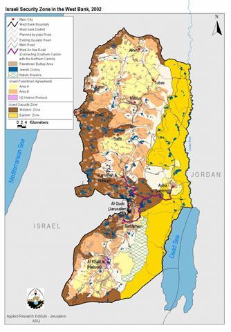
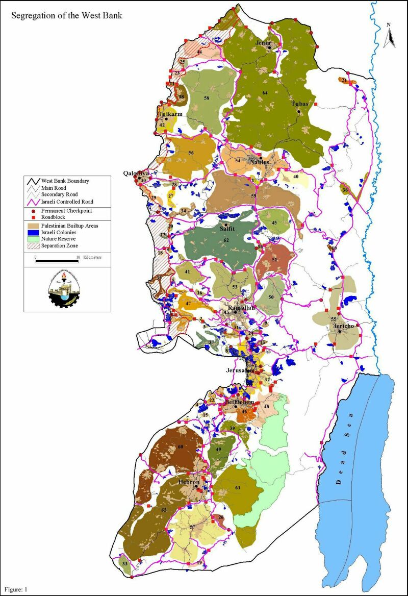
The term bypass road was born with the Oslo Accords to designate roads in the Palestinian territory that link Jewish settlements to military camps and to Israel proper while circumventing Palestinian built-up areas. They are a central tool in Israel's creation of an apartheid system in the territories. The Israeli military has complete control of these roads and frequently forbids Palestinians to use them. These roads carve up the Palestinian areas into isolated ghettos and often deprive Palestinians of vital agricultural land. These practices have fragmented both land and people. During the Al-Aqsa Intifada, the Israelis have made full use of this capability, splitting the Gaza Strip into three separate cantons and the West Bank into 64 .See Map1
This has caused immense damage to the Palestinian economy and has disposed them of the ability to make use of their land.
Israel has succeeded in confiscating Palestinian land by framing their activities within a legal framework; but these justifications changed over time and never created a deterrent to the policy of colonization itself. A primary Military Order used to legitimate the confiscation of Palestinian land is Military Order 58 of 1967, known as the Absentee Property Law. The Military Order transfers lands and properties of absentee Palestinians to the Civil Administration. An absentee is defined as any Palestinian who left the West Bank before or after June 7, 1967. 340 km² were confiscated under Military Order 58 and defined as abandoned property.
In 1969, the Civil Administration issued Military Order 321, which gave the military the authority to confiscate land for public services. It is important to understand that in Israeli terminology, 'public' actually means 'for Jews.' Thus public works in the Palestinian territory are inevitably those that benefit the Jewish settlements, bypass roads being the most common. These Military Orders and others have for the past 35 years facilitated the expropriation of Palestinian land for Israel's colonial project.
The settlements are not subject to any of the legal difficulties that Palestinian communities face. They are administered through a completely different process and the colonists live under Israeli civil law. The plans for the settlements are approved smoothly and the colonists are free to use the land as they please. Even if new settlements are built or land confiscated outside the legal process by the colonists, they are rarely challenged and perhaps are encouraged by Israel authorities. The implications of this discrimination on Palestinian landholding are clear and severe.
3. Israeli Colonization in Bethlehem District
Israeli colonization in Bethlehem commenced during the 1960s after Israel occupied the West Bank in 1967. Kfar Etzion was the first Israeli settlement erected after June 1967 to be followed by a propagation of Israeli settlements in the district. As mentioned above, Israel's establishment of Israeli settlements is an implementation of both the strategies of expansion or separation. In Bethlehem district, Israeli colonization activities have facilitated the separation of Bethlehem district from surrounding Palestinian areas and simultaneously served Israel's political ambitions in expanding the boundaries of Jerusalem to create what is known as greater Jerusalem. See Map 2
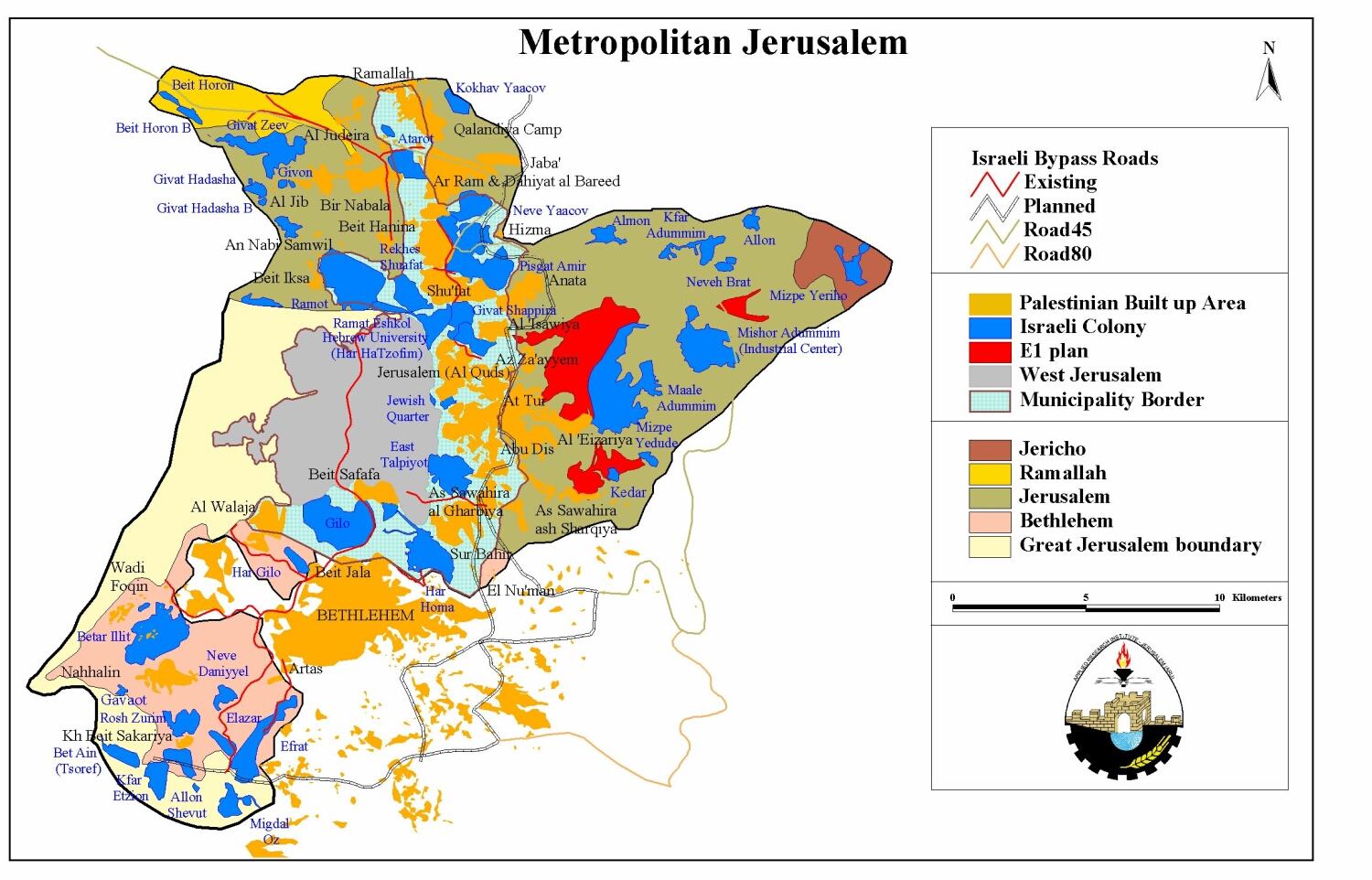
Map 2: Metropolitan Jerusalem
The number of Israeli settlements in Bethlehem district reached 22 constituting a total area of 16109 dunums and accommodating an estimate of 64250 colonists. Thus, 2.65% of Bethlehem district was annexed towards building Israeli settlements. (Table1)
|
Table 1: Israeli Settlements in Bethlehem District |
|||||||||
|
No. |
Name |
Date |
Population |
Area |
Area |
Area |
Area |
Expansion |
Expansion 96-2001 |
|
1 |
Mizpe Shalem B |
n.a. |
n.a. |
6 |
6 |
6 |
6 |
0 |
0 |
|
2 |
Avenat |
n.a. |
n.a. |
0 |
0 |
26 |
26 |
26 |
26 |
|
3 |
Mshoki Dargot |
1991 |
201 |
21 |
21 |
51 |
51 |
30 |
30 |
|
4 |
Gavaot |
1984 |
128 |
59 |
59 |
90 |
90 |
31 |
31 |
|
5 |
Hada Betar |
1978 |
60 |
20 |
37 |
74 |
74 |
54 |
37 |
|
6 |
North Efrat |
n.a. |
n.a. |
0 |
0 |
64 |
64 |
64 |
64 |
|
7 |
Har Gilo |
1976 |
325 |
180 |
180 |
248 |
248 |
68 |
68 |
|
8 |
'Ayn Fashkhah |
n.a. |
n.a. |
0 |
0 |
69 |
69 |
69 |
69 |
|
9 |
Mizpe Shalem |
1977 |
226 |
194 |
194 |
301 |
301 |
107 |
107 |
|
10 |
Elazar |
1975 |
1518 |
229 |
272 |
344 |
344 |
115 |
72 |
|
11 |
Allon Shevut |
1971 |
2138 |
551 |
570 |
705 |
719 |
168 |
149 |
|
12 |
Gilo |
1971 |
28657 |
1955 |
2069 |
2951 |
2972 |
1017 |
903 |
|
13 |
Givat Hamatos |
1991 |
3793 |
95 |
137 |
268 |
298 |
203 |
161 |
|
14 |
El David (Kfar Eldad) |
n.a. |
150 |
22 |
29 |
63 |
95 |
73 |
65 |
|
15 |
Har Homa |
1997 |
n.a. |
0 |
0 |
2149 |
2185 |
2185 |
2185 |
|
16 |
Rosh Zurim |
1969 |
321 |
362 |
400 |
892 |
931 |
569 |
531 |
|
17 |
Nokdim |
1982 |
996 |
175 |
180 |
292 |
338 |
163 |
158 |
|
18 |
Betar Illit |
1989 |
16519 |
430 |
1390 |
3145 |
3202 |
2771 |
1812 |
|
19 |
Tekoa |
1977 |
1027 |
282 |
369 . |
745 |
871 |
589 |
502 |
|
20 |
Efrat |
1979 |
6606 |
663 |
943 |
1600 |
1775 |
1112 |
832 |
|
21 |
Neve Daniyyel |
1982 |
1122 |
112 |
158 |
272 |
550 |
438 |
392 |
|
22 |
Kfar Etzion |
1967 |
463 |
629 |
629 |
881 |
903 |
273 |
274 |
|
Total |
64250 |
5984 |
7642 |
15232 |
16109 |
10124 |
8467 |
||
Source: GIS & Remote Sensing Unit
As shown in Table 1, 84% of the expansion of Israeli settlements in the total period 1990-2001 actually took place during the time spanning 1996-2001, i.e. during Israeli-Palestinian peace negotiations.
Israeli expansion of settlements helps create settlement blocks to merge different Israeli settlements together at the expense of Palestinian geographic contiguity. For example, Etzion settlement block which is made up of 14 different individual settlements is located between Bethlehem city and the 1949 Armistice line (the Green Line). This will make it easier for Israel to claim the settlements as contiguous and as an extension of the State of Israel. It is worth mentioning that Israel considers Etzion block to be part of greater Jerusalem despite its location south of Bethlehem. Most of the Etzion block is built on land originally belonging to the Palestinian villages of Al-Khader, Hussan and Nahhalin. The expansion of Etzion block could prevent any continuity between Bethlehem and Hebron and other Palestinian areas in the southern part of the West Bank. See Map 3
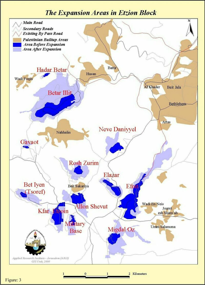
Map 3: The Expansion Areas in Etzion Block
Building Jewish settlements is usually accompanied by the construction of a series of bypass roads. These are built to link settlements together merging them into blocks as well as linking them to Israeli proper ;i.e. these roads facilitate Israel's policy of expansion and separation. These roads are used exclusively by Jewish colonists to commute between settlements and Israel. Moreover, a 75m 'buffer zone' cleared on both sides of these roads results in the confiscation of vast amounts of Palestinian land. Often Palestinian houses are bulldozed in order to clear the land for the buffer zone. Palestinians are forbidden to use this land for cultivation or any kind of construction activity. Thus, these bypass roads create a superimposed grid over the Palestinian areas at the expense of Palestinian integrity and sustainable use of land. The construction of by pass roads has created boundaries around Palestinian areas, fragmenting both land and people.
In Bethlehem district, the existing by pass roads reach 20 km in length. Those that are being constructed or are planned for construction are expected to be 77.5 km in length. Due to the 75-meter buffer zone at the sides of the roads , a total annexation of 16425 dunum of agricultural land in Bethlehem district, which is 2.7% of the total area of the district took place.
Recently, another form of separation implemented by Israel is the construction of military roads. In Bethlehem, a military road has been constructed at its northern boundaries to separate the district from Jerusalem and simultaneously expand Israel's illegal boundaries of Jerusalem. Table 2: Israeli Roads in Bethlehem District
|
Length |
Total Area Annexed(+150 m buffer zone) |
|
|
Existing By-Pass Roads |
20 |
4800 Dunums |
|
Existing Fenced Military Roads |
10 |
1500dunums |
|
Planned Roads including Road 80 |
77.5 |
11625 Dunums |
|
Total Area Annexed |
17925 Dunums |
|
Source: ARIJ GIS Unite, 2002
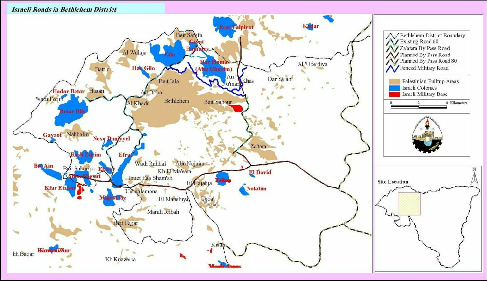
Map 4: Israeli Roads (Existing and Planned) in Bethlehem District
3. The Strangulation of Bethlehem District
Israeli by pass and military roads are one of the crucial means that separate Palestinian territories from each other creating 64 cantons in the West Bank and 3 cantons in the Gaza Strip (see map). Such a geographic interruption is compounded by checkpoints, which make movement between Palestinian separated areas almost impossible. The fact that there is no geographic continuity between Palestinian areas means that there cannot be a viable Palestinian state or a viable Palestinian market in those areas (See map 1).).
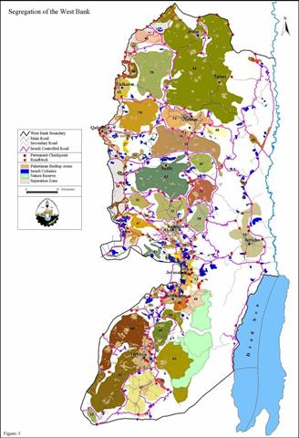
Palestinian areas (cantons) are further divided up by the construction of military roads and road blocks within those cantons. As such, communities are further separated and isolated within an individual district. The combination of such Israeli colonizing activities impose an apartheid system on the Palestinians that aims to undermine the Palestinian right to self-determination and their right to exist as a nation and a state.
Below, map 5 illustrates the separation and strangulation in Bethlehem district caused by Israeli colonizing infrastructures. By a combination of bypass and military roads, Bethlehem is divided into three separate parts: Eastern rural areas, Western rural areas and the urban area in the middle. Below are the Israeli roads that led to such a division: illustrates the separation and strangulation in Bethlehem district caused by Israeli colonizing infrastructures. By a combination of bypass and military roads, Bethlehem is divided into three separate parts: Eastern rural areas, Western rural areas and the urban area in the middle. Below are the Israeli roads that led to such a division:
-
Road 60 located west of Bethlehem district separates the western rural areas from the main urban areas in Bethlehem district. Thus, a total population of 15,000 people cannot commute towards the urban centers because of the presence of checkpoints and road blocks erected on the road.
-
Za'tara planned by pass road is located east of Bethlehem district and is currently under construction. This road will separate the eastern rural area from the urban centers strangulating a total population of 17,000 people.
-
Planned by pass road, Road 80, will be located at the southern boundaries of the district to connect the settlements in Etzion block with the settlements built in the eastern parts of the district such as the settlement of Nekodim. As a result, Bethlehem district will be totally separated from Hebron district located south of Bethlehem district.
-
The fenced military road constructed north of the district will be connected to Road 60 from the west and with Abu Ghunaim settlement from the east. The road creates a security zone made up of Jewish settlements and military bases that is both inaccessible and forbidden for Palestinians. This vast area annexed makes Jerusalem even more distant and separated from Palestinians in Bethlehem district.
As shown in Map 5, the urban centers of Bethlehem district will be encircled by the roads mentioned above and totally separated from surrounding rural areas as well as other urban centers in Jerusalem and Hebron. This will have adverse implications on Palestinian trade and Palestinian labor market. With the presence of by pass roads, checkpoints and road blocks, workers from the rural areas will face enormous difficulties in moving to the urban areas for jobs or trade. As a result, a lot of Palestinian workers will become unemployed and impoverished., the urban centers of Bethlehem district will be encircled by the roads mentioned above and totally separated from surrounding rural areas as well as other urban centers in Jerusalem and Hebron. This will have adverse implications on Palestinian trade and Palestinian labor market. With the presence of by pass roads, checkpoints and road blocks, workers from the rural areas will face enormous difficulties in moving to the urban areas for jobs or trade. As a result, a lot of Palestinian workers will become unemployed and impoverished.
Moreover, the resulting enclaves of Palestinians rapidly become overcrowded due to their inability to expand and absorb natural population growth. This leads to the stifling of development and the overuse and eventual depletion of natural resources. The situation is very serious within the major cities of Bethlehem district where population growth and density is high. The population density in the area encircled by the roads reaches 3730/km2. The surrounding roads will cripple the potential of expanding Palestinian built-up areas to accommodate future increase of Palestinian population. Urban development will also become particularly critical due to the limited availability of land and the future rise of competition on existing Palestinian infrastructure such as roads, sewage system and houses.
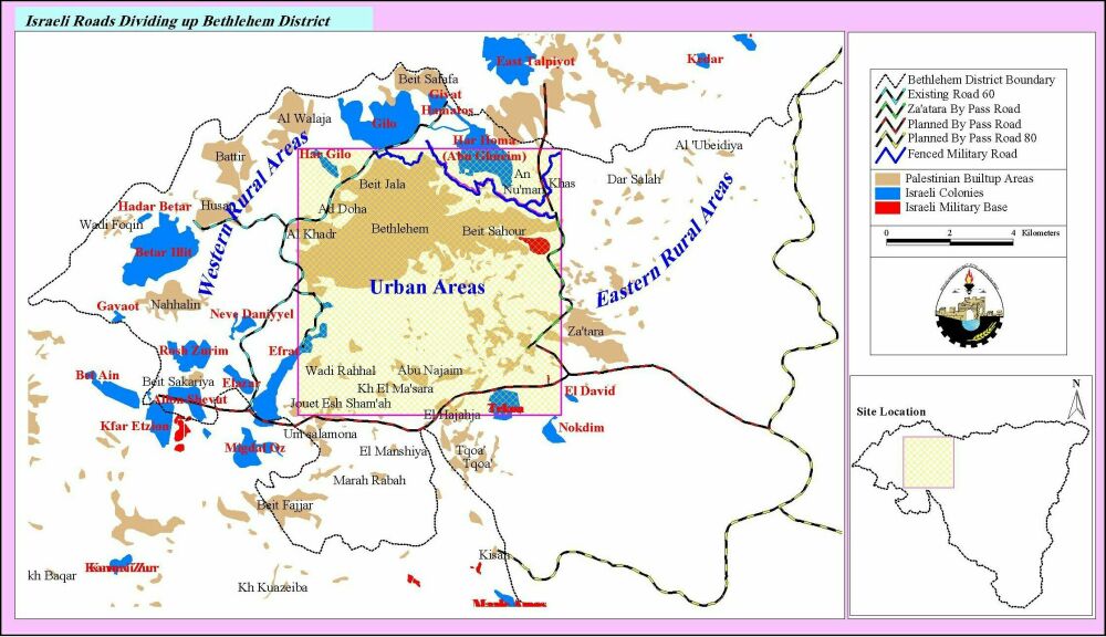
Map 5: Israeli roads dividing up Bethlehem District
Furthermore, the fenced new military road north of Bethlehem district will result in the annexation of agricultural land from Bethlehem district. The road is constructed by encroaching on 652 Dunums within Bethlehem and Beit Sahour municipal boundaries. Approved plans to establish a new industrial zone in Beit Sahour will be crippled due to the new military road that cuts through the area designated for building up the industrial complex.
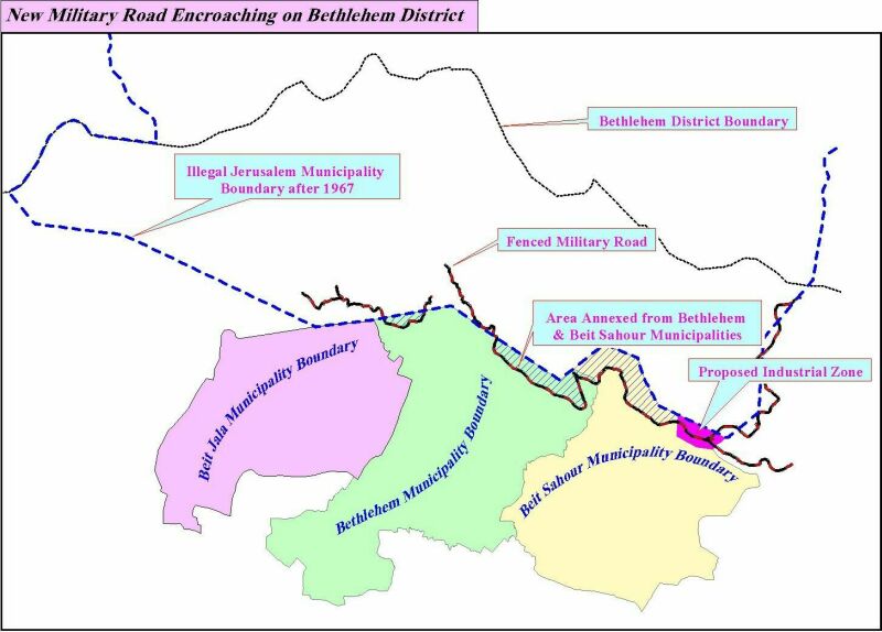
Map 6: New military Road Encroaching on Land Within Beit Sahour and Bethlehem Municipalities
Conclusion
As mentioned above, Israeli colonization in Bethlehem district dramatically alters the geopolitical realities in the area to implement Israel's policies of separating Palestinian areas from each other and from Jerusalem, as well as expand the extent of colonization in the heart of the Palestinian territories, thus delineating the areas in the West Bank that Israel wishes to seize.
Colonization activities in Bethlehem not only separate the district from Jerusalem but also isolate the southern areas of the West Bank from the northern ones. Also, Bethlehem's organic relationship with Jerusalem will be severely affected; Palestinian communities will be fragmented, trade between the two areas will be hampered and access to religious sites in both Bethlehem and Jerusalem will be formidably limited.
Prepared by:
The Applied Research Institute – Jerusalem