Building Jewish settlements is usually compounded by the construction of a series of bypass roads. These are built for the use of Israeli colonists to link settlements to each other and with Israel. At the same time the roads ''bypass'' Palestinian areas, thus creating a physical separation between the two peoples.
A 75m ''buffer zone'' cleared on either side of these roads results in the confiscation of vast amounts of Palestinian land. Often Palestinian houses are bulldozed in order to clear the land for the buffer zone. Palestinians are forbidden to use this land for cultivation or any kind of construction activity. Table 1: Bypass roads' length and buffer area in the West Bank.
|
Existing bypass roads |
|
|
Total length |
347.5 km |
|
Area of the 150m buffer zone |
52.1 km2 |
|
Percent of West Bank Area |
1.86 % |
Source: ARIJ database. Area of W.B = 5,659 km2
To date, the construction of bypass roads has required the confiscation and destruction of approximately 52.1 km² of Palestinian land, most of which is agricultural.
The Israeli Zionist goals in its occupation of the West Bank and Gaza Strip have consistently been guided by two principles, sometimes held in tension with one another: separation and territorial expansion. The construction of bypass roads is used to fulfill both.
The construction of bypass roads commonly occurs along the perimeter of Palestinian built-up areas. This practice has created boundaries around Palestinian areas, fragmenting both land and people. The resulting enclaves of Palestinians rapidly become overcrowded due to their inability to expand and absorb the natural population growth. This leads to the stifling of development and the over-use and eventual depletion of natural resources. The situation is very serious within the major cities of the West Bank where population growth and density is high. Furthermore, Palestinians are restricted from using the bypass roads for their own transportation, particularly in times of heightened conflict. Even parts of road 60, the main north-south artery of the West Bank is often off limits.
Meanwhile, the colonists and Palestinians are subject to two different sets of laws that discriminate against the Palestinians and entrap them in a legal system designed to legitimize the occupation and disenfranchise them from their land. Even though the Jewish colonists and Palestinians inhabit the same land, the colonists enjoy a quality life and access to natural resources that vastly exceeds that of the Palestinians. The situation thus created resembles an apartheid system.
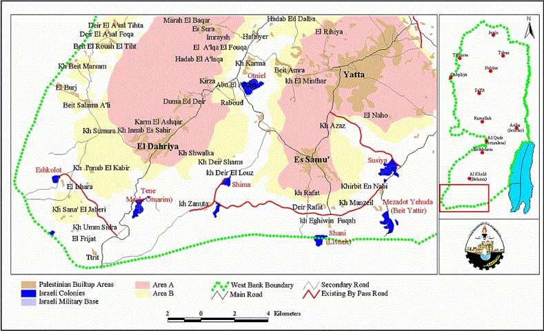
In addition to facilitating separation, the bypass roads are also used to secure territorial expansion. The roads are often built in such a way as to demarcate new de facto borders that will ensure the Israeli annexation of parts of the West Bank in the case of a final settlement with the Palestinians. Examples are numerous. On the southern edge of the West Bank a string of Israeli settlements stretches from Eshkolot in the west to Nof Nesher in the east; see map 1. Here we find two bypass roads linking these settlements while simultaneously severing the connection of many Palestinian villages on either side. It is clear that all the land and villages south of the bypass road are in danger of being annexed to Israel. Even before such a border is officially recognized it functions as such due to the restrictions on Palestinian growth and movement caused by the roads and military checkpoints.. Here we find two bypass roads linking these settlements while simultaneously severing the connection of many Palestinian villages on either side. It is clear that all the land and villages south of the bypass road are in danger of being annexed to Israel. Even before such a border is officially recognized it functions as such due to the restrictions on Palestinian growth and movement caused by the roads and military checkpoints.

The Israeli authorities are using the same strategies extensively in order to secure control over East Jerusalem and its environs. For example, south of Jerusalem bypass roads have been constructed around the Gush Etzion settlement block, separating it from the heavily populated Palestinian area of Bethlehem. The annexation of the Gush Etzion settlement block would involve the absorption of several Palestinian villages; see map 2.

It is clear from this analysis that the primary purpose of constructing bypass roads is not to meet transportation needs but to satisfy political ends. The peace agreements signed between Israel and the Palestinian Authority clearly calls for an end to all actions that would change the status of the West Bank and the Gaza Strip pending the outcome of the permanent status negotiations. The building of bypass roads, complimenting the construction of the Jewish settlements that they serve, undeniably prejudices a final status agreement by carving the West Bank into many small, disconnected Palestinian areas. Israel has only intensified and accelerated its policy of constructing new bypass roads in the West Bank territories during the current Intifada. The following offers a minimal report of Israeli violations through the building of bypass roads see map 3

.
Jericho District:
On November 6, 2000 Barak approved the construction of a 10-kilometer bypass road that will surround the Palestinian village of Al'auja, north of Jericho city. This proposed by-pass road is intended to link Na'ma and Niran Jewish settlements to each other. The Israeli government approved this bypass road under the pretext that Palestinians use the area of the proposed bypass road for throwing stones at the Israeli colonists.
Nablus District:
Wide areas of agricultural land cultivated with olive trees have been razed near Deir Ballut and Kafer Ed Dik villages, southwest Nablus District, in order to expand the bypass road that connects Peduel and Alei Zahave settlements. Moreover, the Israeli colonists started to bulldoze another agricultural area that belongs to Al-Luban Al-Gharbi village, located southeast of Nablus city, in order to establish a new bypass road that will serve the expansion of Israeli settlements in the area and link the settlements of Bet Arye and Alei Zahav with each other.
To the north and northwest of Nablus City, Israeli bulldozers constructed a new bypass road in order to connect settlements there. The bypass road starts from Deir Sharaf village, passes by Sabastiya, Ramin, and Burqa villages and ends at the settlements of Homesh and Enav. As a result of this bulldozing, 200 olive trees and 100 almond trees in Deir Sharaf village, and 800 olive trees in Burqa village have been uprooted. The planned length of the road is around 10 kilometers. If the work on the road continues, more olive and almond trees will be threatened, destroying the livelihood of dozens farmers.
Israeli occupation authorities started bulldozing an area of land estimated at 24 dunums, owned by Yacob Salman from Deir Haris village, southwest Nablus District, in order to open a new bypass road linking Immanuel, Yakir, Barqan B, and Revava settlements. Thus far, 60 olive trees and 20 almond trees have been uprooted due to the construction of this road.
Ramallah District:
The colonists of the Talmon settlement bloc and Nahliel settlement destroyed about 15 dunums of land owned by the villager Yousef Ishriteh from El Mazra'a El Qibliya, with the intention of opening a new bypass road connecting the two settlements with the Haresha outpost. This outpost is erected on lands belonging to El Janiya, Ras Karkar, and El Mazra'a ElQibliya, villages. Furthermore, Israeli bulldozers continue to open a new bypass road on Jibia village land in preparation to expand the new outpost near Hallamish settlement.
Israeli bulldozers, accompanied by 'Ateret settlers, began to open a bypass road leading to land that belongs to villagers from Umm Safa,'Arura, and A'tara villages. The purpose of the road is to erect a new settlement outpost on Al Ras Mountain in an attempt to expand the nearby settlement. At the same time, they started to build a new bypass road that will link Kokhav Yaacov with Beit El settlement.
With the help of the Israeli army, the settlers of Shillo settlement, built on Sinjil village land, bulldozed a wide stretch of Sinjil land to open a new bypass road linking Shillo and Ma'ale Levona settlements. The Shillo settlers had exploited current closure on the West Bank in which Palestinian movement is restricted and started bulldozing and uprooting the fruit trees, damaging thousands of dunums of land that lies in the Alraseed and Abed Alrahman Ben Ouf regions. The colonists have previously tried to seize this land on a number of occasions but the villagers have always managed to prevent them. As a result of the closure, the people of Sinjil village are no longer able to prevent the colonist from constructing this bypass road.
Tulkarem District:
In Shoufa village, southern Tulkarm District, the Israeli bulldozers uprooted dozens of olive trees in order to open a new bypass road close to Avnei Hefetz settlement.
Jerusalem District:
The Israeli Construction and Organization Committee in Jerusalem endorsed a plan to erect a new bridge on the old road leading to Pisgat Zeev settlement. The bridge will be erected to connect the two roads of Yekutiel Adam and Shedrot Moshe Dayan. Several weeks ago the Jerusalem municipality endorsed the confiscation order of 178 dunums from Shu'fat village under the pretext of expanding the road networks leading to Pisgat Zeev and Neve Yaacov settlements. There is a threat that more land will be confiscated from the village.
The Israeli ministry decided to open a new 500m tunnel in Jerusalem, named ''Ashkol tunnel''. This tunnel will start from Mount Scopus road, pass across Shedrot Levi road and will end up at the police headquarters in the Shiekh Jeirah neighborhood.
Israeli bulldozers began construction on 4km bypass road that will link Kidar and Maale Adummim settlements and will take hundreds of dunums from Abu Dis village land. The Israeli Civil Administration decided to construct this road because the current road between these two settlements will end up under Palestinian control in case that they return the Palestinian villages of E'Izariya, Abu Dis and Suahrah in a future agreement.
Hebron District:
In the southern Hebron District the Israeli occupation forces constructed a new bypass road for Shima settlement.
Israel has asked the United States for US$ 1.2 billion to implement the Wye River agreement (AL-Quds Daily, 1998). This money will be allocated to expand Israeli settlements and construct new bypass roads. The Israeli Civil Administration has already planned around 10 bypass roads that are to be constructed as part of the implementation of the interim agreement. However these bypass roads, along with the settlements, are one of the most serious impediments to a just peace between the Israelis and Palestinians. The international community has not held Israel accountable to international law that clearly makes such colonial activity in occupied territory illegal. The Palestinians are paying a heavy price for this lack of political will.
Prepared by:
The Applied Research Institute – Jerusalem