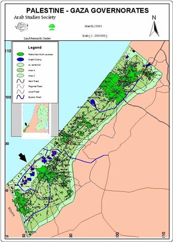
The Land Research Center (LRC) has been exposing the attempts carried out by the forces of Israeli occupation to mince the Palestinian territories into a number of isolated and separated entities through the usage of military blocks and checkpoints. The goal of such policy is to force the Palestinian people into kneeling to occupation in addition to aborting the Intifada. This report sheds light on the Israeli policy of isolation imposed upon the districts of Ramallah and Al Bireh the area of which is 822 squared kilometer and has a population of 243,432 Palestinian. The number of towns in these sister districts is 5 in addition to more than 80 villages, 6 refugee camps and 28 Israeli settlements. Such a large number of villages make Ramallah the prime target for the Israeli isolation policy as this report will expose.
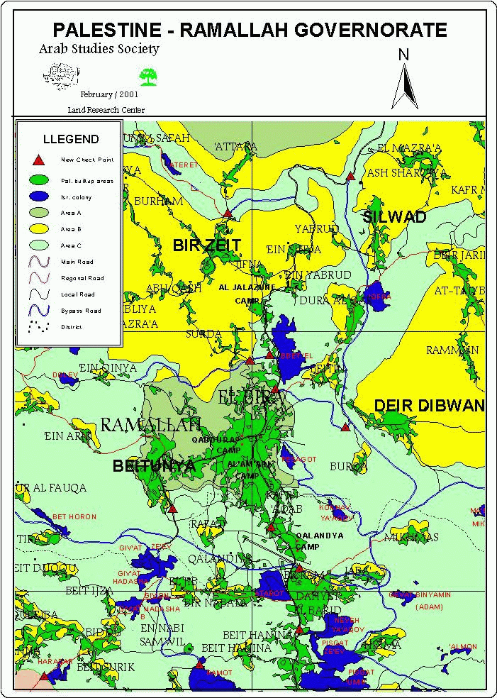
Main Military Checkpoints:
-
There is a military checkpoint at the northern entrance of Al Bireh city next to the City Inn Hotel. The point is located at the by-pass road leading to the Israeli settlement of Beit El. It also rests at the crossroad of the old and the new road leading to Nablus and the road leading to Al Irsal, Beir Zeit and Ramallah. This checkpoint consists of cement blocks, tanks, in addition to mobile machine guns supplied by the nearby Beit El military encampment. It is worth mentioning that the City Inn Hotel has been occupied on a number of occasions. It is currently occupied by Israeli forces, which caused a great deal of damage to the furniture and to the future financial stability of the Hotel.
-
Wad Al Balat Checkpoint aka Eyoon Al Haramiyah. It is located at the main road connecting between Ramallah and Nablus and it takes the British-Mandate-Old Eyoon Al Haramiyah police station as a permanent headquarter.
-
Kufr Aqab- Sameramees Checkpoint at the main entrance point into the southern part of Ramallah via Al Bireh – Jerusalem road. This location has been moved into after the checkpoint was located at Al Ma'afooliah location where a number of martyrdom c741 ,ases and hundreds of injuries were recorded especially during the Tunnel Intifada back in July 1996. Ever since then the checkpoint was moved up 50 meters to be in parallel with the military encampment at the entrance of Ramallah as to provide more security and to cause more problems for the Palestinians.
-
Another blocking point is located at the crossing of Al Attara by-pass road with the Nablus-Ramallah Road in an area called Wad Al Balat. It is a sandy trench located to the south of Eyoon Al Haramiyah checkpoint. Its main function is to prevent movement between Nablus, from one end, to the villages located to the north and south of Ramallah, on the other end.
-
Nabi Saleh Checkpoint. This checkpoint, located in Bani Zeid eastern and western areas, was established by placing cement blocks at the entrance of Halmish settlement. It serves as a separation point between Ramallah and the towns of Deir Ghasanah, Beit Rima in addition to the villages of Qirawa, Kufr Ein, Abood, and the villages located to the west of Salfeet (Kufr Al Deik, Broqueen, Deir Baloot).
-
Ramallah-Beitonia Checkpoint. This checkpoint, established at the entrance of Oafer military camp, separates between Ramallah and the nearby Jerusalem villages of Al Jib, Beddo, Beit Ijza, Qitna, Beit A'anan in addition to Beit Soreek. It also separates between Ramallah and the villages of Beit Liqia, Al Teerah, Beit Oar Al Tahta, Safa, and other Ramallah villages.
-
Khirbetha Bani Hareth Checkpoint, established at the main entrance of the village of Khirbetha. It was later moved in January 2001 due east causing in the process the engulfment of more lands and the re-occupation of a number of villages. Occupation forces names this checkpoint as Kiryat Sefer Checkpoint and it was established atop lands confiscated from the villages of Khirbetha and deir Qidees.
-
The settlement of Oafra Checkpoint. One of the main checkpoints as it separates Ramallah from the following villages: Kufr Malek, Silwad, Deir Jareer, Al Mazra'a Al Sharqiya, Al Taybeh, Ramoon, in addition to Ein Yabrood.
Other checkpoints are categorized here according to their geographical locations.
1. North of Ramallah:
The Old Ramallah-Nablus Road has a number of ditches, sand barriers and cement blocks to prevent the smooth access to and from Ramallah. They include the following:
-
A sand barrier at the entrance of the town of Beir Zeit. This barrier separates between Ramallah and the villages of eastern and western Bani Zeid and is located next to Al Attarah Bridge. It opens up and closes down according to the security situation.
-
Cemented-Checkpoint at the entrance of the settlement of Beit El.
-
Cement blocks in Ein Seinia, on the main Ramallah-Nablus road.
-
A checkpoint at the entrance of the village of Sinjel on the road connecting the village with the villages of Jiljilya and Abweain.
-
Cemented-checkpoint at the main entrance of the village of Turmsayya in addition to a sandy barrier at the western entrance of the villages isolating it, in the process, from the nearby village of Sinjel.
2. South of Ramallah:
-
A sand barrier in addition to mobile patrols prevents the smooth access to Ramallah from Qalandia and Beir Nabala. It has been the case on a number of occasions that the residents of these areas remove these sand barriers or at least make an opening in them to facilitate transportation with ease.
3. Northwestern Ramallah:
-
Attara Bridge Checkpoint. This is a military checkpoint surrounded with cement blocks located at the beginning of Attara by-pass road, about 500 meters away from the last house in Attara village. It denies the residents of Bani Zeid villages' access to the main road.
4. West Ramallah:
-
A military checkpoint isolating Ramallah from the villages of Ras Karkar, Al Jania, Khirbetha, Beitlou in addition to Deir Ammar.
-
A checkpoint at the crossroad of the Dloub and Telmond settlements.
-
A sand barrier located close to Al Teerah military encampment. It separates Ramallah from the villages of Al Teerah, Beit Oar A Fouqa, Beit Oar Al Tahta, Khirbatha, Al Misbah, Beit Liqia, Beit Seira and Safa.
-
A sand barrier built at the entrances of the villages of Beitonia, Ein Areek and Kufr Ni'ama.
5. Southwest of Ramallah:
-
A military checkpoint at the main entrance of the village of Biddo allowing for the controlled access to the village of its residents.
-
A sandy and military barrier exists at the entrance of the Al Jib village facing the settlement of Giv'at Ze'ev. This barrier separates the villages of Al Jib and Beir Nabala from the main road connecting between Giv'at Ze'ev and Jerusalem.
-
Beit Ijza Checkpoint. It is located at the entrance of the village of Beit Ijza close to the main road connecting between the settlement of Giv'at Ze'ev and Jerusalem. It separates the villages of Beit Ijza, Biddo, Beit Diqqo, Beit Anan, Qitna, Al Qabiba from Ramallah.
It is worth mentioning that the villages of Al Jib, Biddo, Beit Ijza, Qitna, Beit Anan, in addition to Beit Soreek are part of the Jerusalem jurisdictions according to the Palestinian and Jordanian administrations. Yet, the Israeli authorities made it so that they are under the Ramallah jurisdiction.
Ramallah Isolation Since the Inauguration of Sharon:
Israeli forces took the occasion of the inauguration of Ariel Sharon as the new Israeli Prime Minister to reinforce its hold on Ramallah and other Palestinian areas as it started executing the plan that called for the transformation of the Palestinian territories into 60 isolated ghettos in a futile effort to suppress the Intifada. The execution of the plan took place between the 6th and the 11th of March as feverish effort was executed to destroy the Palestinian streets, dig up tunnels around Palestinian cities, in addition to placing cement blocks at each road intersection connecting between Palestinian areas. The number of these roadblocks reached up to 90 military checkpoints in addition to the total isolation of cities such as Jericho and Qalqilia as tunnels dug around them prevented the free access to and from these cities. Not only did the Israeli occupation forces dig these tunnels, they even manned these tunnels with military personnel and tanks to harass citizens and even ambulances trying to by-pass the tunnels.
Ramallah was no different as occupation forces besieged the town of Sarda at midnight on the 6th of March after of which they have destroyed the main road connecting between it and the city of Ramallah. They have also destroyed the main road connecting Ramallah and the educational town of Birzeit leaving more than 40 villages, 90,000 student, 4,500 teacher, in addition to tens of thousands of Palestinian residents in total isolation and cut off from the outside world. The student and teacher figures mentioned above include 5000 Birzeit University students and about 500 college professors and university employees, which in effect caused the complete shut down of Birzeit University, a goal occupation forces have been trying to achieve for quite some time.
Prepared by
The Land Research Center
LRC