
Israel ushered in the year 2001 by redrawing the 1949 Armistice Line. In seven locations in the West Bank, checkpoints have been moved several kilometers eastwards; ostensibly for security purposes. Yet, Israel has a history of using the excuse of ''security'' in order to put through other long-sought-for strategies. For this reason, it is essential to evaluate such changes in order to understand the long-term plans that lie behind them.
The distribution of the relocations is as follows: one in Nablus district, three in Ramallah district, one in Bethlehem district, and two in Al Khalil (Hebron) district.
The Trans-'North West Bank' highway (or Trans-Samaria highway as it is known to the Israelis) has been under construction for two years. Not long after the beginning of the Al Aqsa Intifada a section of this road was completed in order to allow residents of Ariel and nearby settlements to access Israel without sharing roads with Palestinians or passing near Palestinian villages. The road passing through Palestinian villages that was previously used has now been blocked with dirt mounds like those used to blockade the entrances to Palestinian villages. Residents of these settlements can now pass into Israel without any contact with Palestinians. The road is only for the use of Israelis; the villagers of nearby A'zun, Mas-ha and Bidya have no access. As part of this road development, the location of the checkpoint has also been shifted. Originally, the checkpoint lay by Oranit settlement on the Green Line. With the opening of the new road, it has moved to a location 5 km east of the Green Line, to south of Bidya village. These changes lead to what amounts to an annexing of the settlements in this area, including Oranit and Elqana. See map
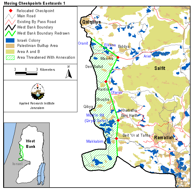
The situation near Oranit is typical of the changes to be found all along the western part of the 1949 Armistice Line. The movement of at least seven checkpoints has been defended by the Israeli army as being for security purposes. However, under the guise of protecting the security of settlers, the army is in effect annexing a number of settlements and large chunks of West Bank land to Israel without waiting for the outcome of any negotiations. At the same time these actions further restrict the lives of Palestinians.
The western boundary of the district of Ramallah has been an unwilling host to much of the Israeli encroachment eastwards. See map.
-
The checkpoint which was formerly located to the north west of Rantis has now been moved several hundred meters east just before the junction between the Ofarim settlement by-pass round and the Rantis-Luban road (road 465).
-
A new military checkpoint has been added to the roadblock at the northeast entrance to Qiryat Sefer. This new checkpoint is on the road that leads to Kharbatha Bani Harith.
-
One of the few checkpoint movements acknowledged by the Israeli army spokesperson (on the IDF web site, 06/01/01) is that near Makkabim settlement. The checkpoint used to be located between the two junctions of roads 3 and 455 with road 443 (the Ramallah-Al Lid road). It has now been moved 1,200m to the east of this location down the Ramallah-Al Lid road in the direction of Ramalah to the east of Beit Sira and before the entrance to Beit Ur El Tihta.
The last two of the above changes are the continuation of a much longer running plan to annex the Modi'in settlement block. The latest changes to checkpoints in this area further increase the land being appropriated by Israel's unilateral moves; for more details click here.
The eastward relocation of checkpoints in the north of the West Bank carries a serious long-term threat. The Israeli goal of annexing that block has been well known for a long time. There is a worry that in the worst scenario they might also try to annex the nearby villages. In addition, the blockade in this area has been very extensive during the current Intifada. The Israeli army has also blocked off the eastern entrance of Khabatha Bani Harith village as well as the eastern and northwestern entrances to Qiryat Sefer settlement. The villages that are affected by the checkpoint relocations and roadblocks are listed in the following table:
|
Locality Name |
Population |
Households |
||
|
Male |
Female |
Total |
||
|
Mas-ha |
1442 |
704 |
2146 |
269 |
|
Az Zawiya |
3695 |
1865 |
5560 |
572 |
|
Rafat |
1467 |
704 |
2171 |
214 |
|
Deir Ballut |
2680 |
1344 |
4024 |
467 |
|
Rantis |
2047 |
971 |
3018 |
298 |
|
Kharbatha Bani Harith |
1036 |
1020 |
2056 |
304 |
|
Deir Qiddis |
718 |
674 |
1392 |
207 |
|
Ni'lin |
1713 |
1648 |
3361 |
544 |
|
El-Midya |
470 |
453 |
923 |
128 |
|
Budrus |
524 |
546 |
1070 |
162 |
|
Qibya |
1786 |
1701 |
3487 |
514 |
|
Shuqba |
1565 |
1502 |
3067 |
436 |
|
Shibteen |
334 |
284 |
618 |
79 |
|
Beit Sira |
2010 |
959 |
2969 |
321 |
|
Beit Nuba |
207 |
94 |
301 |
25 |
|
Total |
21694 |
14469 |
36163 |
4540 |
Source: – Palestinian Central Bureau of Statistics, 1997
The residents of these villages hold Palestinian identification cards and the vast majority work in the West Bank. By cutting them off from the West Bank, Israel is seriously weakening the economies and societies of these villages and facilitating their annexation; click for more. Likud MK Yuval Steinitz has suggested that a new security buffer zone for Israel after the formation of a Palestinian state should be the area between Ariel and Modi'in. This would include the areas of these villages. Although not yet government policy, similar plans have been outlined by Barak's government as well. This would pose a threat to the region containing all the blockaded villages mentioned above. See map.

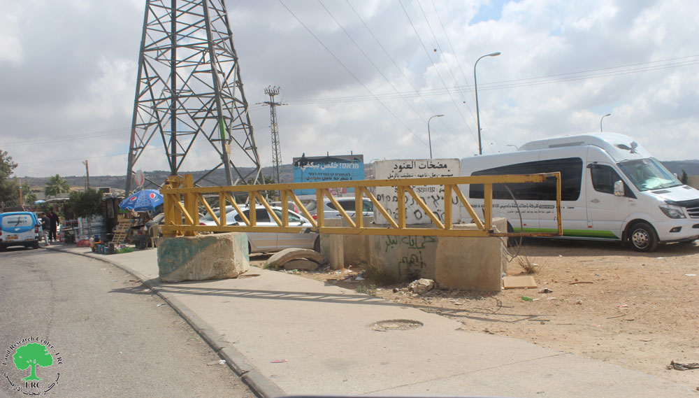
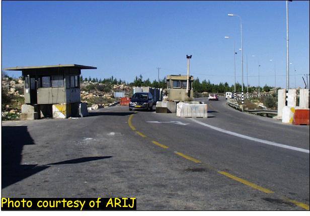
In Bethlehem district, a new checkpoint has been added around one kilometer east of the original checkpoint which is on the 1949 Armistice Line on the road between Betar Illit and Bet Shemesh; click for Photo. The new checkpoint operates between 3 p.m. and 9 a.m. while during the daytime the old checkpoint becomes operational.
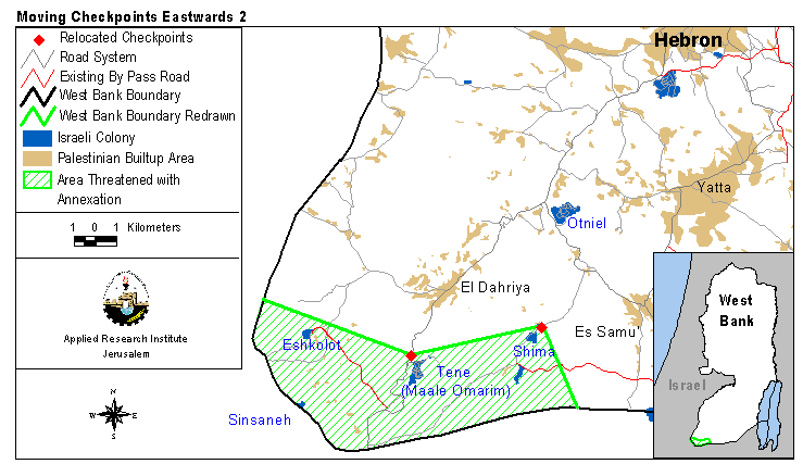
In Hebron, two checkpoints have been relocated to the northeast of their previous locations and past the entrances to the settlements of Tene (Omarim) and Shima. This means that commuting between Israel and these settlements is unimpeded by any checkpoints and hence making them effectively part of Israel; see map.
The annexation of settlements and relocation of checkpoints all seem to be signs of the beginnings of unilateral separation. However, although the Israelis drew up a full separation plan around a year ago, a high-ranking security official informed the Haaretz newspaper (10/01/01) that some of the current moves are not part of such a full plan. This article reported the existence of a separate plan to set up five terminals in order to oversee the movement of goods between Israel and the West Bank. Some will be located at sites of existing checkpoints. The details of the locations of these terminals are still somewhat unclear, though the plan mentions five areas, north of Jenin, west of Tulkarem, southwest of Ramallah, northeast of Bethlehem and Tarkumiya, west of Hebron. Hence, one should expect similar practices in the near future and that more plans would unfold as the Intifada develops.
All such movements have a strong impact on both daily Palestinian life and on the long-term viability of a Palestinian State. Each checkpoint that is changed and each new road that is built allows Israel to edge closer to their preferred state of affairs. By acting unilaterally, Israel threatens the needs of Palestinian society and endangers the livelihoods and quality of life of thousands of Palestinians.
Prepared by:
The Applied Research Institute – Jerusalem


