
-
2.11 : The Israeli occupation authorities prevented dozens of Palestinian farmers from tending hundreds of dunums of land they own near Dogheit settlement causing heavy financial losses taken into consideration that the prevention is still in force.
-
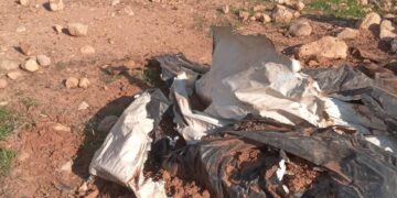
2.11 : Israeli occupation forces bulldozed about 70 dunums of cultivated land adjacent to the border fence with Israel and close to the junction of Muraj settlement separating between the governorates of Rafah and Khan Yunis. The devastation was carried out with the aim of building a road to link between the colonialist blocks of Muraj and Gush Qatif. As arsult, 20 green houses cultivated with tomatoes and cucumbers were destroyed, as well as the destruction of 15 dunums of olive trees and 35 dunums of palm trees and almonds.
-
6.11 : Israeli artillery shelled and destroyed a poultry farm near Al- Muntar cross point killing all the chicken inside and inflicting heavy financial losses on its owner Mr. Ahmad Hasan Ebeid.
-
8.11 : Israeli colonialists who live in Muraj settlement closed with cement blocks and sand dunes the dirt road of Um Al- Qureis which links between the governorates of Rafah and Khan Yunis. They also encircled the road with barbed wires confiscating about 15 dunums of land a long the settlement from the south. The land, which is cultivated with olive trees and almonds, is owned by members from Taheir and Abu Jazer families. By so doing, Israeli colonialists have annexed this area into their settlement.
-
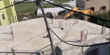
10.11 : Israeli occupation forces bulldozed 450 dunums of land in east Rafah planted with olive trees, oranges, fig trees, Mango trees. Green houses cultivated with tomatoes and cucumbers and other vegetables were also destroyed during this attack which was carried out against the Palestinian land starting from Al- Awdah cross point up to the so-called Daheinyyeh gate leading to the green line for the distance of 3 kilometers and a maximum width of 150-200 meters. In consequence, 5 homes were destroyed. These homes are owned by Ayyub Abed Rabu, Musalem Ab Jarad, Faraj Muhammed Abu Jarad, Saleh Abu Shusha and Hisham Muhammed Abu Shusha. This act of devastation which is considered the biggest in Gaza Strip since many years, came after an Israeli girl and her boy friend were injured.
-
10.11 : Israeli army bulldozers devastated large areas of Palestinian land cultivated with olive trees and almonds on both sides of the Shuhada 'Kasufim' road. The destroyed properties are owned by the families of Abu Haddaf, Al-Seimeri and Al-Agha.
-
15.11 : Israeli bulldozers continue to bulldoze large areas of land on both sides of the road linking between Al- Muntar and Shuhada junction. The length of the area under devastation road is not less than 1500 meters and the width are 700 meters owned by Mr. Sa'ad Allah Yassin. The total area of devastated land is about 200 dunums cultivated with citrus, olive almond, palm trees and forest trees.
-
16.11 : Israeli Occupation authorities started to expand Dugheit settlement located north west of Beit Lahyya after seizing adjacent land classified as public land. The total area confiscated is estimated at 250 dunums situated north and east of the settlement. A 6 meter wide dirt road has been opened around the settlement. Since the beginning of the current uprising, the total area of the land confiscated for this settlement is bigger than the whole area of the settlement before this time.
-
18.11 : Israeli occupation bulldozers destroyed about 50 dunums of agricultural land adjacent to Al- Awdah cross point east of Rafah city uprooting more than 400 olive, citrus and fruit trees.
-
18.11 : Israeli bulldozers destroyed 715 of agricultural land at the eastern side of Sallah Eddin main street linking between the northern and southern sectors of the Strip. The area is located 600 meters south of Kfar Darum settlement and 300 meters from north of Kesufim junction. The target area is planted with palm, olive and almond trees in addition to areas planted with vegetables owned by Abu Amreh, Khatat, Abu Sarsur, Abu Asad, Abu Al- Husein, Shahin, Baraka, Ja'farawi and Laham families. On the other hand, the Israeli occupation authorities bulldozed a strip of land located in Al Salam quarter in Rafah city at the western side of Rafah cross point with a total area of 54 dunums. This act resulted in the destruction of the only water supply line for Al Shawkeh quarter cutting water supply for mare than 300 families.
-
18.11 : The Israeli occupation authorities and after the injury of an Israeli soldier in a road side bomb bulldozed 2 dunums of land cultivated with olive trees owned by Ahmad Kharti and 1 dunum owned by Jamil Abu Khaizeh in addition to destroying an orchard owned by Qa'od Al Wahidi.
-
20.11 : The Israeli occupation authorities bulldozed 5 dunums of land cultivated with olive and palm trees owned by Yusif Bashir west of Kfar Darum settlement near Deir Al Balah. One cistern and a water pump were destroyed as well.
-
22.11 : Colonialists from Kfar Darum settlement seized 10 cabins belonging to Khan Yunis Municipality in Al Mawasi area on the sea side. The cabins were repainted by the colonialists and annexed to the settlement. Moreover, the Israeli occupation forces destroyed 3 houses owned by Mr. Atwa and Mr. Salem Al Idini. They also destroyed An aluminum factory owned by Basel Al Ja'farawi and demolished his house as well. Israeli colonialists set up a tent near Kesufim post and erected a number of caravans near the settlement of Kfar Darum.
-
23.11 : The Israeli occupation forces bulldozed large areas of agricultural land adjacent to Ele Sinai settlement north of Beit Lahiyyah. The total area destroyed is estimated at 200 dunums cultivated with fruitful trees, part of them owned by Mr. Mamdoh Shurafa (26 dunums planted with olives, figs and strawberry); Mr. Ayman Sweilem ( 10 dunums planted with citrus); Mr. Salah Khader (5 dunums planted with citrus); Mr. Fayyez Nahhal (7 dunums planted with citrus).
-
23.11 : Israeli occupation forces destroyed 9 houses belonging to the national security forces near Al- Matahen junction and bulldozed more than 300 dunums cultivated with 3000 fruitful trees. Some of the destroyed land is owned by Mr. Sa'eb Al- Fara, Mr. Adnan Abdeen, Mr. Ashur Abdeen, Mr. Ali Abdeen, Mrs. Sa'dieh Abdeen. Some of the houses destroyed are owned by Suleiti family, Dr. Ahmad Al- Qedrah, Dr. AbdelKareem Mohammed, Mr. Mohammed Nazir Fara andMr. Mustfa Abu- Eidah. A poultry farm and a shed were also destroyed.
40 Israeli military posts and road barricades to besiege residential areas in Gaza Strip and completely separate them from each other … Dec. 3rd, 2000
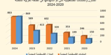
For the ninth consecutive week, the Israeli occupation authorities continue their aggression against the Palestinian people using all means of destruction and killing. So far, more than 300 Palestinians have been killed and 10 000 wounded, third of them are children under the age of 16 all hit by Israeli bullets, rockets and shelling fired from land, sea and air.
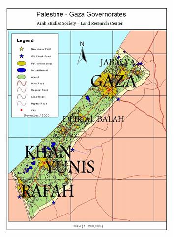
Gaza Strip:
More than one million and one hundred fifty thousand Palestinians live in the Strip whose total area is 365 square kilometers, 40% of this small area is controlled by the occupation authorities. That is, 146 square kilometers out of the total area is used for Israeli settlements, military posts and roads, Erez check point area and border strip with Egypt. The remaining 219 square kilometers are like a big prison for more than one million Palestinians whose areas are cut off by more than 40 military posts and road barriers, 5 of them were erected before September 29, 2000. These road barricades have become flash points and confrontation lines between Palestinian demonstrators and Israeli soldiers where 95 Palestinians were killed and 2750 injured.
Israeli military posts and road block:
-
Erez border Check point: established immediately after the occupation of the Strip in 1967 war (in Arabic Beit Hanun) as a main passage way for laborers and goods.
-
Nahal Uz border check point east of Shajayyeh: it is used as a passage way for fuel and livestock to and from Israel.
-
Karneh border check point east of Gaza city (in Arabic Al- Muntar): it is used as a passage way for all kinds of goods and for colonialists entering and leaving the settlement of Nitsarim.
-
A military post at the borders of Erez industrial zone north of the Strip.
-
A military post south east of Dugheit settlement north west of the village of Beit Laheyyah.
-
A military post and road barricade west of Dugheit settlement along the coastal road north of Beit Lahyyah.
-
A military post near the entrance to Dugheit settlement in the north western side.
-
A military post in the vicinity of Nisanit settlement north of Beit Laheyyah village.
-
A military post and a detention center inside Erez check point.
-
Two military posts at the borders of Nitsarim settlement, one to the west and one to the east of the settlement.
-
A military post at the Shuhada (martyrs) junction on the only high way linking between the northern and southern parts of the Strip ( in Hebrew Nitsarim settlement junction).
-
A military post a long the main road west of Kfar Darum settlement.
-
Two military posts in the vicinity of Kfar Darum settlement, one in the north and the other in the east of the settlement.
-
A military post in the agricultural area belonging to Kfar Darum settlement, east of Al- Mahata area in Deir Al- Balah.
-
A military post on the main road north of kfar Darum settlement.
-
A military post and barricade on the junction leading to Qararah north of Khan Yunis.
-
A military post on Kisufim settlement road north of Qararah north of Khan Yunis.
-
A military post under the name of Kisufim at the border line with Israel east of Qararah used as a crossing point for army and colonialists.
-
A military post on the main road junction leading to the colonialist block of Qush Qatif north of Khan Yunis governorate.
-
A military post at the entrance to the main road linking between the colonialist block of Qush Qatif from the northern side.
-
A military post on the coastal road between the governorates of Deir Al Balah and Khan Yunis (Ayalon check point at the entrance of Al- Mawasi from the northern side.
-
A military post at the coastal road south of the recreation area belonging to Qush Qatif colonialist block at Khan Yunis sea.
-
·Two military posts at the borders of the settlements of Nitzer Hazani and Qatif west of Qararah.
-
Two military posts at the borders of Gali Tal settlement west of Khan Yunis.
-
A military post under the name of Al- Tufah on the sea road linking between Al- Mawasi area west of Khan Yunis -An agricultural area with a population of 5000 people- and the governorate of Khan Yunis.
-
Three military posts surrounding the settlement of Qali Tal, north of Al- Amal quarter in Khan Yunis.
-
A military post at the borders of Bidoleh settlement located west of Rafah city.
-
A military post occupied by the Israeli border guard soldiers inside the settlement of Beit Sade near Mawasi Rafah.
-
Two military post at the borders of Muraj settlement located on the main road between the governorates of Khan Yunis and Rafah, one in the southern direction and the other in the eastern direction of the settlement.
-
A military post along the settlement of Kfar Yam on Khan Yunis sea side.
-
A military post on the main road between the governorate of Rafah and Al Mawasi area under the name of Sultan check point. 2500 people live in this area.
-
A military post on the borders between Rafah and the Egyptian territories close to the Swedish village located on the coast.
-
A military post on Tel Zu'rub land along the border line north west of Rafah.
-
A military post on the borders between Rafah and Egypt along Yebneh quarter.
-
A military post on the borders between Rafah and Egypt along block 5 (Salah Eddin gate).
-
A military post on the border line between Rafah and Egypt along Al- Salam quarter.
-
A military post at the entrance to Rafah crossing point with Egypt ( Sofa crossing point) which was set up after the occupation of 1967 and used as a passage way for construction materials and agricultural workers.
-
A military post at the entrance to Daheinyyeh village located south east of Rafah.
Prepared by
The Land Research Center
LRC