• About The Project
  • Palestine in Century
  • Selected Maps
  • Glossary
  • About ARIJ
  • About LRC
  • By Year
    • Case Studies By Year
    • Daily Report By Year
Wednesday, April 29, 2026
POICA
No Result
View All Result
  • Home
  • Settlements
    • New Israeli Settlements
    • Settlement Expansion
  • Israeli Violations
    • Agriculture
    • Confiscation
    • Demolition
    • Environment
    • Eviction of Palestinians
    • Settlers Attacks
  • Bypass Roads
  • Israeli Plans
  • Segregation
    • Checkpoints
    • Closure
    • Separation Plans
  • Military Orders
  • Reports
    • Daily Report
    • Monthly Report
    • Quarterly Report
No Result
View All Result
POICA
No Result
View All Result

The Forgotten Hebron

October 11, 2000
in Israeli Violations
The Forgotten Hebron


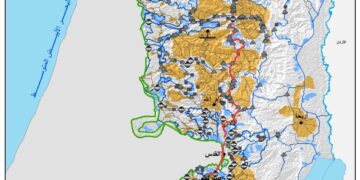
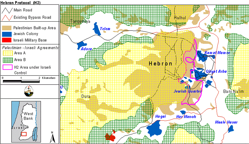
According to the 1995 Taba Agreement, Palestinians Hebron City is divided into areas H-1 and H-2, due to the presence of Israeli colonists within the city boundary; see map1 .  The Palestinian Authority exercises civil authority over Palestinians in both areas, while Israel retains control over internal security and public order in H-2. There are 20,000 Palestinians and 200 permanent Jewish colonists living in H-2. The Jewish numbers are supplemented by a further 200 Jewish colonist supporters who come in the daytime from other colonies in the West Bank.


Map1: Map showing the division of Hebron city.


1500 Israeli soldiers are deployed in area H-2 ostensibly to protect the Israeli colonists from Palestinian attack. However, these soldiers have consistently protected the Israeli colonists while attacking Palestinians. Not only that, but there have been frequent attacks on journalists that report violations of colonists in Hebron while the Israeli army stood watching see aerial photo. The population of Hebron city is around 180,000 and 20,000 of those live in the H2 area. However, the local people say that over half the Palestinian population residing in the H2 area have moved into area H1 because of the continuous harassment and hardships they face every day; see link .  . The population of Hebron city is around 180,000 and 20,000 of those live in the H2 area. However, the local people say that over half the Palestinian population residing in the H2 area have moved into area H1 because of the continuous harassment and hardships they face every day;  .


Aerial photo: Aerial photo showing the location of Israeli neighborhoods inside Hebron. Taken from an Israeli website.   


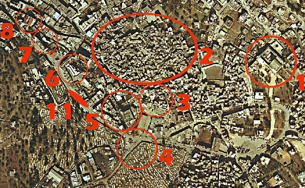
Key to Aerial photo:

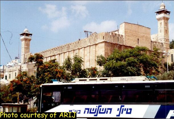
1: Al-Ibrahimi mosque/ Tomb of the Patriarchs. The Israelis have seized two thirds of it; see photo.


2: The old city

3: Beit Nahoom Ve Yahuda colony; 4: Gross Square; see photo.      

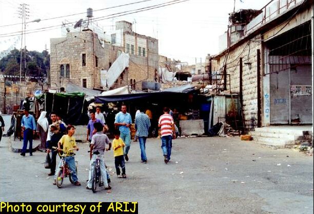
5: Arab Market; see photo.       


6:  Beit Romano colony where Ussama Ibn Al-Munther school used to be; 

7: Al-Dabboya colony; 8: Beit Hadassah colony.

Since September 28 Hebron City has been totally blockaded, all the entrances have been closed by concrete blocks and checkpoints that completely isolate area H1 (Area A) from the district villages (area B & C), see map2 . The Palestinian residents of area H2 have been living under some of the worst conditions in the Palestinian territories. They have been under curfew for 30 days, with no connection to other parts of the city. Three people have been killed and hundreds injured. People have suffered water and electricity cuts, 32 schools have been closed and four are being occupied by Israeli soldiers and converted into military bases.      . The Palestinian residents of area H2 have been living under some of the worst conditions in the Palestinian territories. They have been under curfew for 30 days, with no connection to other parts of the city. Three people have been killed and hundreds injured. People have suffered water and electricity cuts, 32 schools have been closed and four are being occupied by Israeli soldiers and converted into military bases.   

Map 2: map showing the location of Israeli checkpoints.


The presence of Israeli colonists and soldiers in Hebron is a source of constant suffering for the Palestinians. The Palestinians that reside in Hebron live in extraordinary conditions that disrupt their daily lives in ways that make peaceful coexistence practically unattainable. As can be seen from the maps, the goal of Israeli policies is to keep this area separated from the rest of the West Bank. The latest clashes show an ominous Israeli vision of the future shape of the West Bank.  The Hebron district is only one case in point illustrating the threat posed to the viability of a future Palestinian State by isolating the Palestinian communities from each other.


Prepared by:
The Applied Research Institute – Jerusalem


Recommended For You

INFOGRAPHIC: ISRAELI SETTLER VIOLENCE IN 2025

by arij
April 16, 2026
0

INFOGRAPHIC: ISRAELI SETTLER VIOLENCE IN 2025     Prepared by:   The Applied Research Institute – Jerusalem  

Read moreDetails

أدوات غير مباشرة للاستيطان الإسرائيلي في مناطق (أ) و(ب) لإعادة تشكيل الجغرافيا والسيطرة في الضفة الغربية   

by arij
April 16, 2026
0
العدالة المؤجلة ورأي بلا تنفيذ: من قرار المحكمة إلى واقع الضم

منذ توقيع اتفاقيات أوسلو في تسعينيات القرن الماضي، تم تقسيم الضفة الغربية إلى ثلاث مناطق إدارية وأمنية: (أ)، (ب)، و(ج)، بهدف تنظيم المرحلة الانتقالية نحو تسوية نهائية. وبموجب...

Read moreDetails

INFOGRAPHIC: Palestinian Trees – Victims of the Israeli occupation Army & Settler Groups in 2025

by arij
April 16, 2026
0

    INFOGRAPHIC: Palestinian Trees - Victims of the Israeli occupation Army & Settler Groups in 2025 Prepared by:   The Applied Research Institute – Jerusalem  

Read moreDetails

ذكرى الـ 50 ليوم الأرض: فلسطين بين ذاكرة الدم وصمود البقاء    

by arij
April 16, 2026
0

في الثلاثين من آذار، لا يستحضر يوم الأرض في الوعي الفلسطيني بوصفه مناسبة رمزية عابرة، بل كحدث تأسيسي متجدد يعكس استمرارية الصراع على الأرض والهوية. وبعد مرور خمسين...

Read moreDetails

الاحتلال الإسرائيلي يستهدف مشاريع تنموية في قرية جورة الشمعة جنوب شرق بيت لحم

by arij
March 14, 2026
0
الاحتلال الإسرائيلي يستهدف مشاريع تنموية في قرية جورة الشمعة جنوب شرق بيت لحم

في يوم الاربعاء الموافق الرابع من شهر اذار من العام من العام 2026, سلمت سلطات الاحتلال الاسرائيلي (الإدارة المدنية الاسرائيلية) أهالي قرية جورة الشمعة جنوب شرق مدينة بيت...

Read moreDetails
Next Post
Recent Israeli Plan for Cantonizing the Palestinian Territories

Recent Israeli Plan for Cantonizing the Palestinian Territories

LATEST NEWS

مناطق نفوذ المستوطنات ودورها في إعادة تشكيل الجغرافيا الفلسطينية

مناطق نفوذ المستوطنات ودورها في إعادة تشكيل الجغرافيا الفلسطينية

by arij
April 23, 2026
0

........................................................

التمدد الاستيطاني الإسرائيلي في الضفة الغربية المحتلة وأثره في تقويض مقومات الدولة الفلسطينية

التمدد الاستيطاني الإسرائيلي في الضفة الغربية المحتلة وأثره في تقويض مقومات الدولة الفلسطينية

by arij
April 16, 2026
0

........................................................

INFOGRAPHIC: ISRAELI SETTLER VIOLENCE IN 2025

by arij
April 16, 2026
0

........................................................

العدالة المؤجلة ورأي بلا تنفيذ: من قرار المحكمة إلى واقع الضم

أدوات غير مباشرة للاستيطان الإسرائيلي في مناطق (أ) و(ب) لإعادة تشكيل الجغرافيا والسيطرة في الضفة الغربية   

by arij
April 16, 2026
0

........................................................

flag_yellow_lowEU-PfP-Logo

This website and its content were initiated in 1993 by the Applied Research Institute – Jerusalem (ARIJ) and the Land Research Center (LRC) with the support from the European Union up until 2023. Since then, the Applied Research Institute – Jerusalem (ARIJ) has taken over the continued development and maintenance of the website. The views expressed remain solely those of ARIJ) and do not necessarily reflect those of the European Union.

© 2026 Copyright | ARIJ | All Rights reserved.

No Result
View All Result
  • Home
  • Settlements
    • New Israeli Settlements
    • Settlement Expansion
  • Israeli Violations
    • Agriculture
    • Confiscation
    • Demolition
    • Environment
    • Eviction of Palestinians
    • Settlers Attacks
  • Bypass Roads
  • Israeli Plans
  • Segregation
    • Checkpoints
    • Closure
    • Separation Plans
  • Military Orders
  • Reports
    • Daily Report
    • Monthly Report
    • Quarterly Report

© 2026 Copyright | ARIJ | All Rights reserved.