
This report highlights the events concerning colonizing activities in the West Bank and Gaza that occurred between the months of September and November. The report describes and evaluates those events and their effects on the Palestinian community. The report also tries to predict the repercussions expected in the future as a result of those events.
Contents:
- Background
- West Bank
- Jerusalem
- Gaza
- In Depth Analysis of Key Events
Background:
The Madrid Peace Conference of October 29, 1991 was a major turning point in the status of the West Bank and Gaza after the 1967 war. For the first time, the Palestinian Territories were invited to a meeting addressing the Middle East conflict. Although it was not on an equal basis, it was a start. This conference provided the legitimacy and the framework for future rounds of peace negotiations and agreements. The direct outcome of the Madrid Conference was the birth of two separate negotiating tracks: the bilateral and multilateral talks. Soon after, separate bilateral negotiations were initiated between Israel from one side and the Palestinians, Lebanon, Jordan, and Syria on the other. Multilateral talks on key regional issues have been frequently held as well. Negotiations between Israel and the Palestinians on the interim period started in Washington, D.C. The composition of the Palestinian negotiating team was restricted at this time to members who were residents of the West Bank and Gaza Strip.
The lack of progress in the bilateral negotiations led to secret meetings arranged and hosted by the Norwegians. These meetings led to the adoption of a two-stage solution. The first stage was an interim period of five years during which Palestinians would be permitted limited autonomy in the West Bank and Gaza Strip. The critical issues of water allocation control over resources, East Jerusalem refugees, and the Israeli settlements were to be negotiated during the permanent status negotiations, which were scheduled to start on May 1, 1996. The behind-the-scenes negotiations, which took place in Oslo, Norway, achieved a major breakthrough in the Palestinian-Israeli relations, and brought the PLO and Israel to sign the 'Declaration of Principles' (DOP) in September, 1993.
The DOP contained mutually agreed upon general principles for the interim period. It requested Israel to turn its authority over civil issues in the West Bank to the Palestinian Authority. During the interim period, Israel would continue to control security of borders and Israeli colonists in the West Bank and Gaza Strip. In order to elaborate on the practical application of the DOP, the 'Agreement on the Gaza Strip and the Jericho Area', was signed in May 1994. That agreement, which later became known as Oslo I, resulted in the withdrawal of the Israeli forces from approximately 78% of the Gaza Strip and 6,130 hectares in the Jericho area. The 22% of the Gaza Strip which remained under Israeli control included 'yellow areas,' Israeli colonies, and an Israeli security zone.
The Israeli-Palestinian Interim Agreement on the West Bank and the Gaza Strip (commonly known as 'Oslo II') was initiated in Washington, D.C. on the 28th of September 1995. Oslo II set out a policy for election of the Palestinian Council and defined its authority, established Palestinian self-government in the West Bank, and set a schedule for redeployment of the Israeli army from populated Palestinian areas. The agreement also focused on security arrangements between Israel and the Palestinian Authority. As of today, Israel has not fulfilled a large segment of the Oslo II Agreement.
The Interim agreements have divided the lands of the West Bank into three classifications: areas A, B, and C. The Israeli military withdrew from lands classified as area A, and complete autonomy over administrative and security issues was assumed by the Palestinian Authority. Area A, according to the Oslo II agreement, covered the main cities of the West Bank, except for Hebron which had a special agreement. The city of Hebron was divided into areas of different control called H1 and H2. Area H1 is defined as area A and area H2, which houses 400 colonists, remains under Israeli control.
In areas B, the Palestinians have full control over civil affairs while Israel continues to have overriding responsibility for security. These areas comprise most of the Palestinian towns and villages. Areas C, covering almost 74.3% of the West Bank, are under Israeli control. Areas C covers the area, which falls outside areas A and B. In this area, the Palestinian Authority provides civil services; however, Israel retains full control over land, security, people, and natural resources. The majority of Palestinian agricultural land lies in these areas.
In the summer of 1996, there was a change of government in Israel and Benjamin Netanyahu, the Likud party leader, rose to power. His agenda concerning the occupied territories diverged from that of his predecessors and the peace process plunged into a series of crises. Not only that but there was also an upsurge in the colonizing activities to the extent that Israeli officials publicly called upon the colonists to grab as many hilltops as they can. That land grab policy resulted in the establishment of over 40 outposts during the three years that Likud held power.
Furthermore, Netanyahu was reluctant to honor the agreements signed by predecessors thus he placed the peace talks in a stalemate. Consequently, on the 23rd of October 1998 the Wye River Memorandum was signed to 'facilitate implementation' of the Interim agreement between the Palestinians and Israel. The memorandum stipulated further redeployments that would give the Palestinians control over about 40% of the West Bank (Table 1). The redeployments were to be conducted in three stages and it was projected that after completion of the third stage, area A would be approximately 18.2% of the West Bank, area B would be 21.8%, and the remaining areas would continue to be area C (Wye River Memorandum, 1998). The first stage was put into effect on November 20, 1998, two weeks after the agreed timeline and the following two stages were stalled. On December 15, 1998, the Israeli government announced its decision to stop further redeployment, and froze the implementation of the Wye agreement indefinitely.
Table 1: The redeployments as mentioned in the Wye River Memorandum
|
|
Total Area A |
Total Area B |
Total Area C |
|
Stage I |
10.1% |
18.9% |
71.0% |
|
Stage II (not implemented) |
10.1% |
23.9% |
66.0% |
|
Stage II (not implemented) |
18.2% |
21.8% |
60.0% |
Source: adapted from The Wye River Memorandum, October 23, 1998
Since the Wye River Memo encountered obstacles in implementation, it needed a new agreement in order to see it through. So on the fourth of September 1999, the Sharm El-Sheikh Memorandum was signed. In general, this memo reiterated each party's commitment to uphold its previous obligations yet with a bit of detailing on certain issues. The Permanent Status talks were to resume in an accelerated manner and a deadline was set (September 2000) for their conclusion. The memo also contained clauses detailing the release of prisoners, the operation of the Gaza Port, the Safe Passage Route, and modifications in the stages of redeployment. The first and second stages were implemented (albeit after delays) while the third stage, which was scheduled for the 20th of January 2000, has not been implemented (Table 2).
Table 2: The redeployments as mentioned in the Sharm El-Sheikh Memorandum.
|
|
Total Area A |
Total Area B |
Total Area C |
|
Stage I |
10.1% |
25.9% |
64.0% |
|
Stage II (implemented in delay) |
12.1% |
26.9% |
61.0% |
|
Stage II (not implemented) |
18.2% |
21.8% |
60.0% |
Source: adapted from The Sharm El-SheikhMemorandum, September 4, 1999.
The final status negotiations, which were supposed to commence in May 1996 and end by 1999, were officially started in early September 1999. In the meantime, the Israeli government has not stopped its unilateral practices in the West Bank and Gaza strip by which it created de farealities on the ground. These de facto realities are clearly prejudicing the outcome of negotiations on the final status of the Occupied Territories to Israel's favor. Such activities are in total violation of United Nations' resolutions, particularly 298 and 242, as well as standing Palestinian-Israeli agreements.
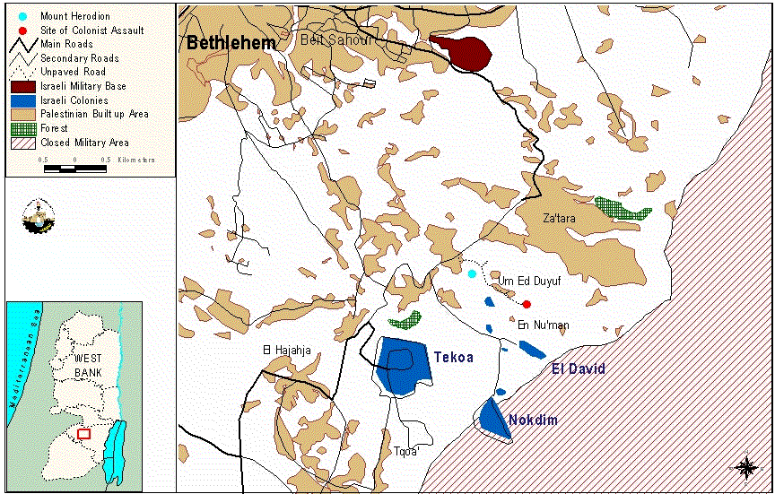
The West Bank
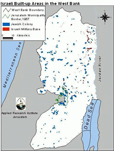
The West Bank is a landlocked geographic entity created as a consequence of the 1948 war (see map). The borders demarcating the West Bank are those appearing in the maps of the 1949 Armistice agreement signed by the Arab states and Israel. In 1967 Israel occupied the West Bank annexing East Jerusalem while treating the rest of it as 'Administered Territories'. The international community, however, does not recognize Israel's annexation and refers to the West Bank (including East Jerusalem) as the Occupied Territories. The area of the West Bank is 5822 km2 and its Palestinian population in 1997 was 1,873,476 (PCBS, 1998). It includes 642 Palestinian built-up areas comprising 359 km2 (GIS database, ARIJ, 1998). In addition, there are eighteen refugee camps scattered throughout.
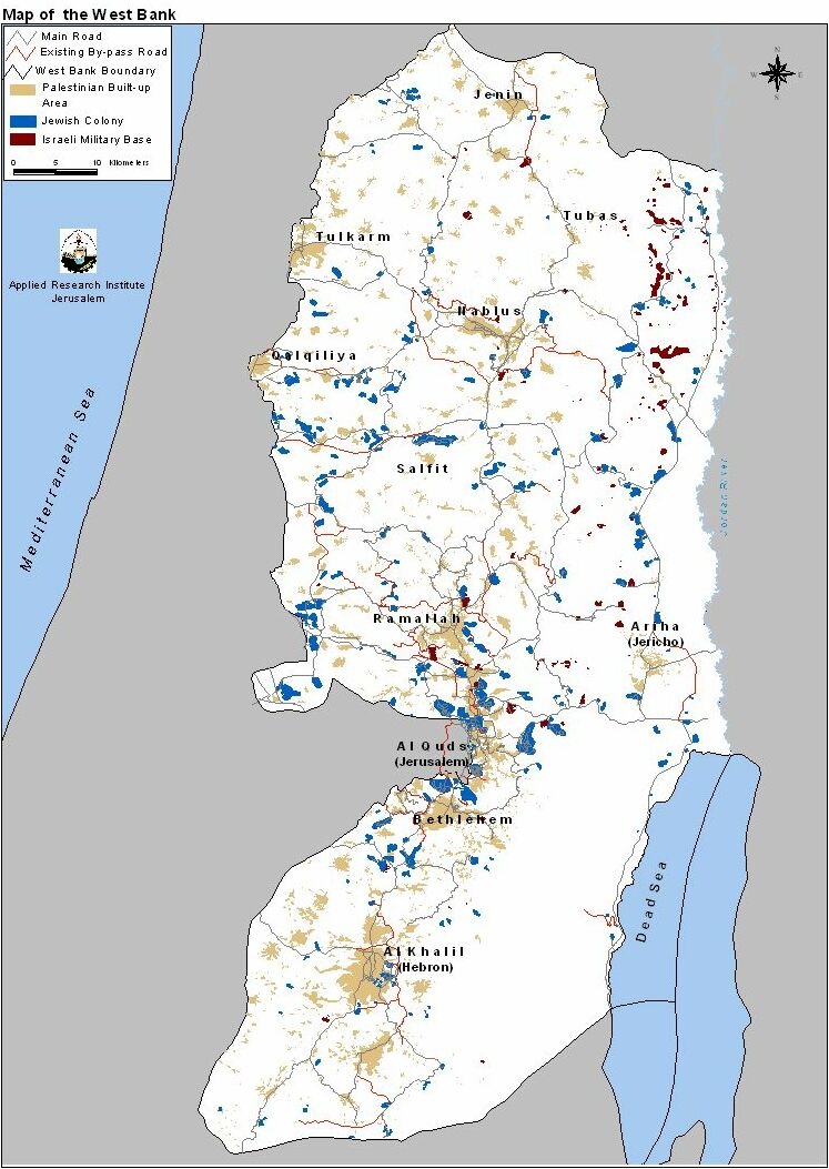
However there are over 250 Israeli built up areas (civilian and military) in the West Bank covering an area of 147 km2 (GIS database, ARIJ, 1998). Yet, Israel recognizes only 124 as independent municipal bodies. Currently the colonists number around 340,000 of which 170,000 are in East Jerusalem alone.
As is apparent from the map, the Jewish colonies in the West Bank are scattered all over (see map). However successive Israeli governments have encouraged the development of specific blocks more than others. Notably, the focus has been on the following areas:
- the Jerusalem area to create demographic barricades in front of any Arab claims to it,
- Along the West Bank's western edges so as to make the return to the 1967 borders practically impossible.
- The Jordan valley for its presumed importance to Israel's security as well as for its agricultural resources (abundant water and fertile soil).
Furthermore, the growth of colonies is mainly geared to the formation of blocks; i.e. they grow outwards and towards each other. The end result of such a growth is the grouping of Palestinian towns and villages into three or four cantons. Indeed, the Israeli intention is to make the contiguity of any Palestinian State in the future practically unattainable.
In addition, Israel builds by-pass roads to link colonies with each other and with Israel proper (see map). This designation came with the advent of the Oslo Accords and was not present before. In the agreements they are called 'Lateral Roads' but people usually call them 'bypass' roads because they are meant to circumvent (i.e. bypass) Palestinian built up areas. These roads are of course under Israeli control and entail a 50 to 75 meter buffer zone on each side of the road in which no construction is allowed. In effect, these roads carve up the Palestinian areas into isolated ghettos and deprive Palestinians of vital agricultural land. Moreover, these roads become political boundaries since most of them are inaccessible to Palestinians from the West Bank (photo 1, Photo2).

To achieve its schemes of colony expansion and by-pass road construction Israel utilizes a variety of policies. From issuing military orders, to land confiscation, to house demolition, and uprooting trees, Israel continues to transform the West Bank every day. The Israeli violations that were reported between the months of September till November are discussed in the following section.
Table 3: Israeli Violations in the West Bank from September to November 1999
|
Date |
Violation |
Location |
Violators |
Notes |
|
05-Sep-1999 |
Expanding of Kaddim /Gannim colonies |
Jenin |
Israeli authorities |
Area of expansion 250 dunums |
|
06-Sep-1999 |
Closing the Ibrahimi Mosque for Muslim worshippers for six days during the Jewish holidays |
Hebron |
The Israeli military forces |
Access will only be granted to colonists and Orthodox Jews |
|
12-Sep-1999 |
Seizure a piece of land, in order to open a new road, 400 meters in length |
Hebron – Halhul |
Colonists of Karmei Zur |
|
|
17-Sep-1999 |
Plans to build 88 housing units in Kedar colony |
Jerusalem |
A private contractor |
The plan doubles the size of Kedar. |
|
17-Sep-1999 |
Endorsement of a plan to construct a huge Israeli tourist colony |
Bethlehem – Etzion Bloc |
The Israeli Housing Ministry |
|
|
18-Sep-1999 |
Expansion of Susiya boundaries northwards and eastwards, in addition to the installation of 10 caravans on 4 dunums of land |
Hebron – Susiya colony |
Colonists of Susiya |
The land has lost 150 dunums to the colony. |
|
20-Sep-1999 |
Planning of building a new checkpoint which will run parallel to the existing one and will be used by Palestinians only |
Between Bethlehem & Jerusalem |
The Israeli authorities |
|
|
21-Sep-1999 |
Prohibition of the villagers from cultivating their 80-dunum land |
Bethlehem – Kh. Beit Skariya |
The Israeli authorities |
|
|
23-Sep-1999 |
Attempt to block an internationally funded project to help Palestinian agriculture |
Bethlehem – Etzion enclave |
Jewish colony leaders |
|
|
23-Sep-1999 |
Fencing around 40 dunums of land, endeavoring to construct additional housing units |
Hebron – Tarqumia |
The colonists of Telem |
|
|
24-Sep-1999 |
Military post near Homesh/Sa Nur colonies |
Nablus– |
Israeli authorities |
The post lies on a one-dunum area. |
|
26-Sep-1999 |
2,600 new tenders have been issued for house constructions in the colonies |
West Bank |
Israel's Housing and Construction Ministry |
|
|
26-Sep-1999 |
Closing off 23,000 dunums of land |
Hebron – Beit Ula & Edna |
The Israeli military forces |
|
|
27-Sep-1999 |
Tender issued for a new by-pass road connecting Shaked and Katzir colonies. |
Jenin |
Israeli authorities |
|
|
27-Sep-1999 |
Tender issued for a new by-pass road connecting Kiryat Arba and Ramat Mamre colonies. |
Hebron |
Israeli authorities |
|
|
27-Sep-1999 |
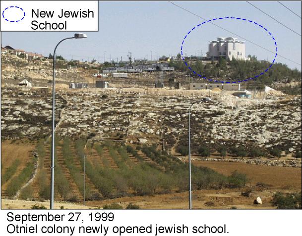
Attendance of the ceremony of opening a large Jewish school |
Hebron – Otniel colony |
Israeli officials |
|
|
29-Sep-1999 |
16 military orders have been issued to seal off large areas of fertile agricultural land |
West Bank |
Israeli authorities |
also see in depth analysis below. |
|
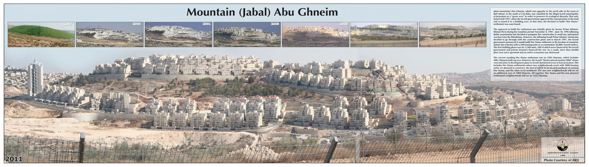
01-Oct-1999 |
Marketing 600 housing units in Har Homa colony. |
Bethlehem – Jabal Abu Ghneim |
Israeli authorities |
|
|
01-Oct-1999 |
Construction of 500 housing units in Maale Adumim colony. |
Jerusalem |
Israeli authorities |
|
|
04-Oct-1999 |
Sealing agricultural plots of land to be used as Israeli training fields |
Hebron – Sa'ir, Bani Na'im, Yatta |
The Israeli army |
The sealed area is estimated at over 80 km2. |
|
06-Oct-1999 |
Erecting two mobile homes |
Ramallah – Talmon colony |
Jewish colonists |
|
|
06-Oct-1999 |
Setting up two mobile houses |
Hebron – Susiya colony |
Jewish colonists |
|
|
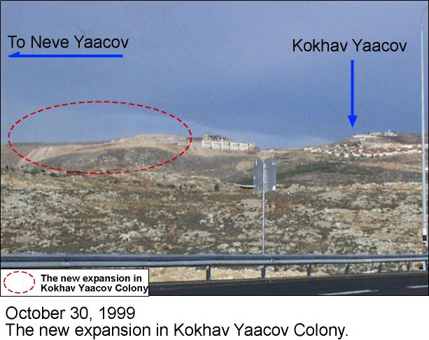
12-Oct-1999 |
3,000 colony housing units are in the process of building |
Ramallah – Kokhav Yaacov colony |
The Israeli Housing Ministry |
|
|
15-Oct-1999 |
Approving the establishment of 35 colonies |
West Bank |
PM Barak |
see in depth analysis below |
|
18-Oct-1999 |
A military order has been issued to prohibit the renovation of Palestinian houses |
Hebron – close to Ibrahimi Mosque |
The Israeli occupation authorities |
|
|
20-Oct-1999 |
Expansion of Maale Shomron colony. |
Qalqilieh-Azzun |
Israeli authorities |
Area of expansion is 5 dunums |
|
20-Oct-1999 |
Erecting a mobile synagogue in an illegal outpost |
Hebron – Havat Maon colony |
Ultra-orthodox Jews |
|
|
22-Oct-1999 |
The land of the evacuated colonies' outposts will remain under the Jewish colonists' control |
West Bank |
Barak & the colonists |
see in depth analysis below |
|
02-Nov-1999 |
Expansion of Karne Shomron colony. |
Qalqilieh-Kufer Laqif |
Israeli authorities |
The area of expansion is 14 dunums. |
|
02-Nov-1999 |
A plan was ratified to build 37,000 housing units to bring in 185,400 colonists |
Bethlehem – Etzion Bloc |
The Israeli government |
It was first proposed by the so-called 'Higher Council of Planning' |
|
03-Nov-1999 |
Uprooting dozens of olive trees |
Ramallah – El Midya |
troop of Israeli soldiers |
|
|
07-Nov-1999 |
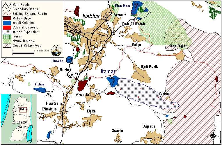
Expansion of Itamar colony's Master plan from 700 to 7000 dunums |
Nablus- Awarta and Kafr Qallil |
The Israeli government (PM Barak) |
|
|
15-Nov-1999 |
New tenders have been published to build 2,703 new colony housing units |
West Bank |
The Israeli government (PM Barak) |
|
|
15-Nov-1999 |
Demolition of six houses and evicting hundreds of Palestinian Bedouins from caves and stone shacks |
Hebron – Yatta |
Israeli troops |
|
|
23-Nov-1999 |
Setting up an illegal outpost |
Bethlehem – Etzion Bloc |
The members of Dor Hahemshech |
|
|
24-Nov-1999 |
Demolition orders for 30 cistern wells used for irrigation |
Bethlehem – El Khader |
The Israeli Civil Administration |
|
|
26-Nov-1999 |
Approving the constructing of 1,026 new housing units on 26,000 square meter of land |
Bethlehem – El Khader & Artas |
The Israeli government |
|
|
28-Nov-1999 |
Moving of five Jewish families (Yeshiva) into an Isreali army unit base |
Hebron – Old city |
Isreali military forces |
|
|
29-Nov-1999 |
Demolishing of 7 stores and stone shacks and 3 cistern wells |
Bethlehem – El Khader |
The Israeli forces |
Source: compiled from local newspapers, interviews and field survey.
Table 4: Direct colonizing activities by Jewish colonists in the West Bank throughout the months of Sep-Nov, 1999.
|
Name of Colony |
Name of Arabic location |
Area in dunums |
No. of housing units |
Nature of Activity |
|
Immanuel |
Deir Istia, Salfit, Jensafut, |
451 |
– |
Confiscating the land and illegally registering it |
|
Shilo |
Ra'as Musa, Qaryut, Nablus |
1200 |
5 |
Annexing the land without prior notice and building on it |
|
Rachelim |
Talama, Sawieh, Nablus |
80 |
14 |
Annexing the land without prior notice and building on it |
|
Shvut Rahel |
Khafafish, Jalud, Nablus |
1026 |
7 |
Annexing the land without prior notice and building on it |
|
Karne Shomron |
Ra'as Amer, Jensafut, Qalqilieh |
42 |
– |
Annexing the land without prior notice and building on it |
|
Total |
|
2799 |
26 |
|
Source: compiled from interviews and field survey.
Table 5: Tenders for construction in colonies in the West Bank published by the Israeli government during the months of Sep-Nov, 1999:
|
Date |
Name of colony |
District |
No. of housing units to be built |
|
14.9.1999 |
Ramat Mamre |
Hebron |
12 |
|
1.11.1999 |
Asfar (Metzad) |
Hebron |
9 |
|
4.11.1999 |
Sa Nur & Gannim |
Jenin |
14 |
|
15.11.1999 |
Arial |
Salfit |
54 |
|
Total |
|
|
89 |
Source: compiled from Publication Of Tenders For Construction In The Settlements By The Barak Administration, Peace Now.
Planning schemes projects for expanding Israeli colonies on Palestinian land in West Bank:
A. Bidding for planning schemes
- A planning scheme was prepared for the colony of Elkana in Qalqilieh district and was sent for bidding on 1.11.1999 under the number of1/15/125.
- A new planning scheme for Jadu'nim colony built on land belonging to the village of Beit Furik, Nablus was sent for bidding on 8.11.1999 under the number of 3/163. According to this scheme, 30 housing units will be built on a total area of 4285 dunums.
- A project to build a new colonialist road was sent for bidding on 22.10.1999. The project whose number is 2/8/115 will be build on land belonging to the villages of Azzun and Kufer Thuluth in Tulkarm district.
- Issuing and approving 4 planning schemes in the Hebron district affecting 1860 dunums.
B. Commencement of a number of planning schemes:
1. A final approval was given to a scheme aimed at enlarging Salit colony. According to this scheme whose number is 2/1/112, about 175 housing units will be built on 847 dunums. The date of commencement for this project is 22.9.99.
2. A scheme to enlarge the colony of Revava situated on Deir Istia and Haris villages in Salfit district entered into force on 12.11.1999.
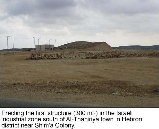
3. Erecting the first structure (300 m2) in the Israeli industrial zone south of Al-Thahiriya town in Hebron district (see Photo).
Jerusalem
The state of the Palestinians' human rights in Jerusalem is deteriorating at an accelerating rate. The Israeli occupation is trying to build more facts on the ground to Israelize the Holy City; to make it, as they claim, the eternal capital of Israel. As a result of the Israeli policies:
-
Palestinian Jerusalemites are prevented from using more than 86% of their land upon which Israeli occupation built more than 15 colonies. The remaining land is kept as a strategic reserve for the expansion of the colonies.
-
The number of Jewish colonists in occupied Jerusalem is about 170,000 colonists. Their number in 1967 was zero.
-
More than 2000 houses were demolished since 1967, more than 350 of which were demolished under the pretext of building without permit.
-
More than 100 homes were seized in addition to two neighborhoods inside and outside the Old City.
-
The military closure of the city since the 30th of March 1993 has caused devastation on the economical, social, and political levels.
Since the beginning of September 1999, field workers based in Jerusalem documented the following violations in the Jerusalem area:
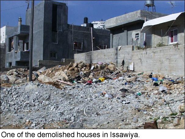
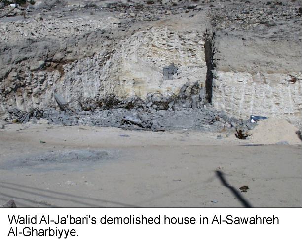
Table 6: House Demolitions
|
Name of victim |
Date of demolition |
Location |
Area in m2 |
No. of rooms |
No. of family members |
No. of children |
|
Ihab Yusif Nasser. |
26/10/1999 |
Eisawieh |
100 |
4 |
6 |
0 |
|
Faizeh Fuad Khalil |
25/10/1999 |
Beit Hanina |
60 |
4 |
8 |
5 |
|
Sarah Fuad Khalil |
25/10/1999 |
Beit Hanina |
60 |
3 |
9 |
4 |
|
Najwa Fuad Khalil |
25/10/1999 |
Beit Hanina |
60 |
3 |
8 |
6 |
|
Walid Al-Ja'bari. |
15/11/1999 |
Al-Sawahreh Al-Gharbiyeh |
|
|
|
|
|
Total |
|
|
280 |
14 |
31 |
15 |
Source: compiled from interviews and field surveying on the sites.
-
The continuation of the Israeli colonialist construction in Ras Al-Amud Palestinian quarter.
-
A military order was issued closing 300 dunums of Nabi Samual village in preparation for total confiscation for the exclusive use of Jews.
-
The Israeli army issued a number of orders to evacuate 17 families who have been living in Nabi Samual village since 1954.
-
The Israeli authorities continue to build road No. 1 in Jerusalem that connects Pisgat Zeev colony with the western side of Jerusalem. This road is being built on land confiscated from Palestinians of Shu'fat village. As part of the road construction, an historical old mosque was destroyed.
-
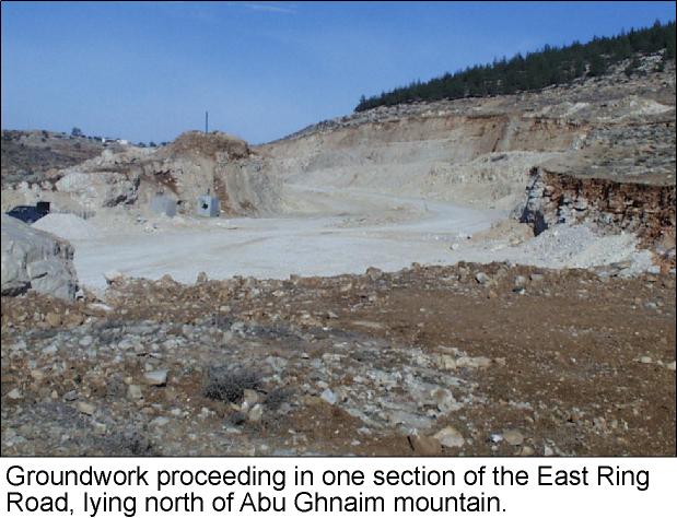
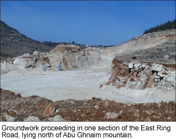
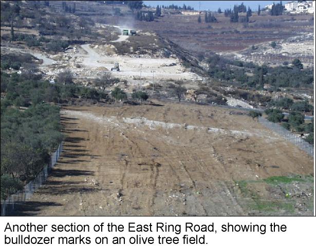
The Israeli authorities started groundwork without prior notification on a large stretch of land for the construction of the East Ring Road next to Sur Baher village, south of Jerusalem (click to see photo).
-
On the other hand, works are still under way to build road No. 45 in the lands of the Palestinian areas of Qalandia, Judeira, Bir Nabala, Jib (Click to see photo1, photo2). This road will meet the tunnel road No. 60 that crosses the city from south to north.
-
Mr. Khader Budran was killed after being shot at by Israeli Police on the 1st of October 1999. The incident took place in Ramot colony under the pretext that he did not stop as the Police asked to. In addition, Mr. Ayman Al Sheikh, whose was sitting next to Khader, was also killed after the dead driver lost control of the car and it hit the pavement violently before it came to a complete stop.
The Gaza Strip
Gaza is a narrow strip of land located across the southern western side of Palestine (see map).
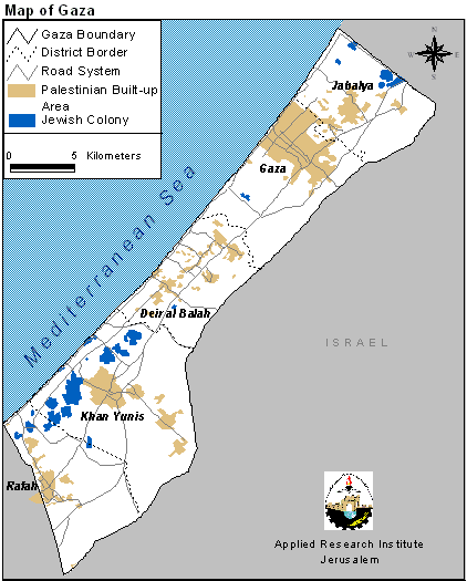
The Strip is 45 km long and it is between 6 to 12 km wide. The total area of the Strip is 363.8 km squared. The population of Gaza is about 1 million. With such data, Gaza is considered one of the most over crowded areas in the world with a rate of 3018 person per km squared (in the case of discounting the area under Israeli occupation). Finally, the percentage of young people under the age of 15 is about 50%. Agriculture is the main economic activity in the Strip. Main agricultural products include palm and citrus trees in addition to the different types of vegetables. The Strip also has a large labor force. Yet, the Israeli occupation has deployed a number of policies that has affected the economic activity in the Strip in a negative way. Such policies include:
-
The confiscation and seizure of agricultural lands,
-
The seizure of water sources and the over pumping of it to supply it to the Israeli colonies. This action has led to the increase of both the pollution and the salt concenof the water.
-
The isolation of the Strip from other markets which caused a great damage to the agricultural environment.
-
The increase of the number of the unemployment in Gaza.
Despite the small area of the Strip and the fact that there exists a great number of Palestinian refugee camps (their total area is about 110,000 dunums), we find that Israeli colonizing activity led to the seizure of about 59,000 dunumsof Palestinian land in the Strip. That is about 16.3% of the total area of the Strip. The usage of these dunumsis divided as follows:
-
43,000 dunums were used to build 20 colonies atop of them,
-
775 dunumswere declared closed military areas and used exclusively for the usage of the Israeli occupation forces.
-
15,000 dunums used as security zones for the protection of Israeli colonists.
The geographical distribution of the Israeli colonies in Gaza was designed to accomplish two goals:
1. To isolate, as much as possible, Palestinian centers from reaching the Mediterranean Sea. This goal has been achieved through the establishment of 16 colonies parallel to the Mediterranean Sea in the south of the Strip.
2. To control the main road that divides the Strip into three distinct areas, which allows for their easy isolation. This goal has been achieved through the establishment of the 3 colonies of Erez in the north, Kfar Darom in the middle of the Strip, and Morag in the south.
Moreover, the Israeli occupation established colonies in Gaza Strip with functional objectives with the aim of serving the occupation. These colonies include military ones that aim at achieving complete military and security control over the Strip and its coastal area in addition to the Egyptian borders. They also include agricultural colonies to which vast areas of land were annexed and used as farms by the colonists in order to achieve three goals:
1. Controlling vast areas of Palestinian land;
2. Controlling sources of underground water in the Strip;
3. Using the Gaza Strip land and water for cultivating special kinds of vegetation like flowers and citrus fruits (economic reason).
The Israeli occupation authorities also set up a number of industrial colonies with the aim of utilizing cheap labor in Gaza Strip to produce Israeli products for local and international markets.
A large network of roads was built to serve Israeli colonies. It comprises two categories:
1. Internal roads connecting colonies to each other and connecting colonies with main roads;
2. Main roads that connect the three colonist blocks in the south, north and center of the occupied land with Israel proper.
Although a number of these roads pass by areas under the Palestinian sovereignty according to Oslo accords, the Israelis are still having security control over these roads supported by permanent and random checkpoints. Often, the Israeli army and colonists prevent Palestinian from using these roads, especially those roads leading to Netzarim and Kfar Darom colonies where Palestinians face arbitrary checks and are not allowed to travel on these roads individually, but in commune (more than one person in a car).
Table 7: Israeli Violations from September to November 1999 in the Gaza Strip
|
Date |
Violation |
Location |
Violators |
Notes |
|
16-Sep-1999 |
Leveling off the land in order to annex it to the nearby colony of Gush Katif |
Rafah -Al Mallahat farm |
Colonists from Gush Katif |
Area of expansion 20 dunums |
|
28-Sep-1999 |
Establishment of a military point next to Kfar Darom colony |
Khan Younis -Road in Deir Al Balah |
Colonists form Kfar Darom |
The area is 0.15 dunums |
|
30- Sep-1999 |
The annexation of a land owned by the family of Abu Shaloof to connect between the colonies of Pe'at Sadeh and Mizp `Azmona. |
Rafah – Piece 2370 – Parcel 1 |
Colonists from the two colonies. |
Area of annexation is 70 dunums |
|
01-Oct-1999 |
The construction of a sandy road connecting the colony of Neve Dekalim with a 200-dunum piece of land that the colonists took over a year earlier. Plastic houses were constructed on the land ever since. |
Rafah – Tul Jinan South of the colony of Neve Dekalim |
Colonists from Neve Dekalim |
Area of construction 250 dunums |
|
10- Oct -1999 |
Eviction order under the pretext that the land is a State Land. |
Rafah -Tul Jinan Block 92 Parcel5 |
State Guardian |
Area of the land is 12 dunums. |
|
13- Oct -1999 |
Surrounded by an electronic fence in order to annex it to the colonies of Gadid, Gan Or, Bedolah, Mizp `Azmona |
Khan Younis |
The colonists of these colonies |
Area of expansion 2000 dunums |
|
14-Oct-1999 |
Leveling off and planting the land for the benefit of the colonies of Katif and Netzar Hazzani |
Khan Younis – Mawasi Al Qirara Block 89 |
The colonists of Katif and Netzar Hazzani
|
Area of the land is 1500 dunums |
|
03-Oct-1999 |
Leveling off the lands with the intention of annexing it to the colony of Gannei Tal |
Khan Younis – Al Amal neighborhood |
The colonists of Gannei Tal |
Area of the land is 100 dunums |
|
14-Oct-1999 |
Prevention of completing a house. |
Khan Younis – beach |
The State Guardian |
The house gave shelter to a 10-member family. |
|
01-Nov-1999 |
The construction of two additional housing units in the colony of Pe'at Sadeh |
Rafah |
The colonists of Pe'at Sadeh |
|
|
05-Nov-1999 |
The construction of an 800-meter sandy road in order to annex a 160-dunum land to the colony of Pe'at Sadeh |
Rafah |
The colonists of Pe'at Sadeh |
Area affected is 5 dunums. |
|
14-Nov-1999 |
Leveling off the land in preparation to annex it to Pe'at Sadeh |
Rafah – south of Pe'at Sadeh colony |
The colonists of Pe'at Sadeh. |
Area of the land is 10 dunums |
Source: compiled from interviews and field surveying on the sites.
House Demolition:
Location: Khan Younis Camp
Date: 23-11-1999
Demolishing Pretext: Building on State Land
No. of Houses: Six houses under construction
Names of House Owners: 1) Ayesh Mohamed Abu Sahlool (50 years)
2) Sami Hussein Abu Kharees (33 years)
3) Muneer Salman Abu Sahlool (35 years)
4) Ahmad and Hani Ali Al A'araj (24 & 27 years)
5) Ahmad and Ayman Abu Sahlool (25 year)
In Depth Analysis of Key Events
The Sharm El-Sheikh Memorandum
The Sharm El-Sheikh Memorandum had two important modifications in the clauses addressing the redeployments. First, the two stages that remained unimplemented in Wye were further split into three. Second, the redeployments where scheduled to be concurrent with the final status talks and not precede them; that puts the Palestinian negotiators at a disadvantage
Unlike Oslo II, Wye River Memorandum and Sharm El-Sheikh Memorandum mention percentages of redeployments without describing where those redeployments are planned. The Wye River Memo states that 3% should be 'Nature Reserves' and that 'Israeli officials acquaint their Palestinian counterparts as required with areas…,' while Sharm El-Sheikh Memo doesn't mention the Nature Reserves and succinctly talks of percentage 'transfers.' This meant that Israeli officials would supply maps of the withdrawals only after the signing of the agreement. Moreover, the area of the West Bank according to which the percentages are calculated is not specified. The area of the West Bank is 5854 km2 and the total area of the transfers from Area C to Area B is 384 km2. Dividing this number by the former gives a percentage transfer of 6.56% and not 7% as the Sharm El-Sheikh Memo claims. However, when one excludes East Jerusalem, the No Man's land, and the territorial waters of the Dead Sea, the area of the West Bank becomes 5538 km2 and the percentage of the withdrawal dilates to 6.93%. Thus, quite to the convenience of the Israeli authorities, the percentage transfers (calculated over a smaller patch of land) appear larger than what they really are. This distribution (as evident from the map) works well with Israel's plans of cantonizing the West Bank. It totally avoids Jerusalem and the Jordan Valley, it minimizes the transfers in Ramallah that has a sizable array of colonies, and allocates the bulk of the withdrawals in arid areas of Hebron.
On the other hand, the new transfers have made Area B more contiguous. For example, B and A areas south and west of Nablus have become connected. However numerous Palestinian hamlets remscattered islands in a sea of 'C' areas along the western parts of the Nablus and Ramallah districts. The Palestinian villages of Nahalin and Skarya remain surrounded by Israeli colonies that continue to encroach on them. It is important to note that, to the Israeli forces, transfers from Area C to Area B do not form a significant change since security in 'B' areas is still in Israeli hands. Yet to the colonists, these transferscomplicate their ability to create facts on the ground. For example, colonist stopped a Palestinian land reclamation project in al-Khader village on the grounds that it was located on an area designated as C.
However, what is most noteworthy in the new maps is the modification of 'Area B'. Two regions that were designated as 'Area B' in The Wye River Memo appear as 'Area C' in the Sharm El-Sheikh Memo maps. In the village of Walajeh as well as in Abu Dis, areas that were previously designated as 'Area B' appeared as 'Area C' in the new maps.
New Military Orders In the Wake Of Sharm El-Sheikh Memo
Just after the signing of the Sharm El-Sheikh Memo, 16 military orders where distributed closing vast areas of the West Bank (See map). On the 5th of May 1999, 16 Israeli military orders were approved by the Israeli military command sealing off large areas of land in the West Bank as closed training grounds. However, the villagers were not informed of these orders until the 6th of September 1999 (i.e. after the signing of the Sharm El Sheikh Memorandum which was on the 4th of September 1999). Yet the closures overlap areas designated as 'Area B' in Sharm El-Sheikh Memo. In fact, it was only after a massive public uproar that the Israeli authorities issued new orders correcting the overlap in areas designated as Area B.
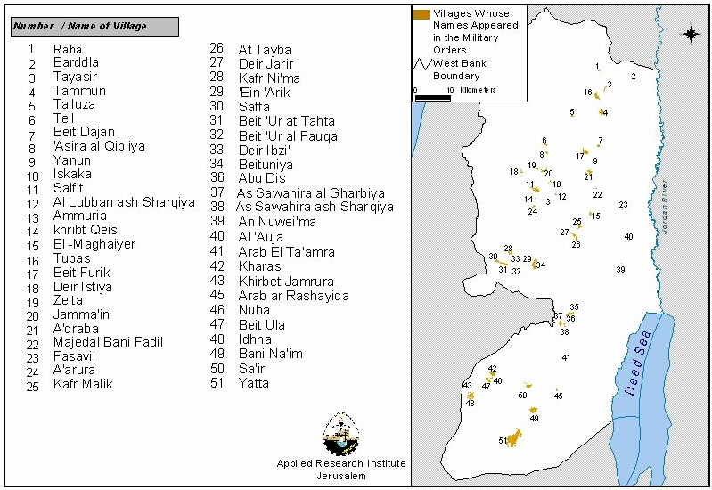
Moreover, a number of Palestinian houses are threatened with demolition despite the fact that they lie in 'Area B' . In addition, the military orders specifically state that the closure does not apply to persons living within the designated area. Nevertheless, several people living within the closure area were ordered to leave. Usually, the closing of an area for military training is limited by a specific time period; these 16 orders are open-ended. Thus, claiming that these orders are administrative and routine (i.e. independent of political developments) is invalid.
Since most of the land is agricultural, these live-fire-training grounds affect Palestinian families that make their living from agriculture and livestock. Moreover, the proximity of the closures to Palestinian built up areas impedes their development and natural growth.
Table 8: The military orders issued after the Sharm El-Sheikh Memorandum.
|
No. of military order |
Area in dunum |
Location |
Notes |
|
1/S/99 |
. |
Al-Sawahreh, Nabi Musa, Khan Al-Ahmar, Abu Dis, Al-Ezzariya, Al-Obeidieh, Arab Al-Taamre, Arab Al-Rashaideh, Sair, Bani Naim, Yatta, Arab Al-Jahalin. |
Map not available. |
|
2/S/99 |
|
|
missing |
|
3/S/99 |
|
Ne'ma, Al-Auja. |
Map not available. |
|
4/S/99 |
. |
Duma, Al-Mugheir, Al-Auja, Kufr Malek, Deir Jarir, Al-Taiba. |
Map not available. |
|
5/S/99 |
|
Al-Mugheir, Raba, Tubas, Bardala, Tayaseer. |
Map not available. |
|
6/S/99 |
>472000
|
Yatta, Bani Naim. |
The map does not show all the closed area. The area appearing in the incomplete map is over 472000 dunums. |
|
7/S/99 |
|
Aqraba, Beit Furik, Beit Dajan, Yanun, Majdal Bani Fadel, Fasayel, Ghor Al-Far'a. |
Map not available. |
|
8/S/99 |
|
Talouza, Beit Dajan, Beit Furik, Yanun, Aqraba. |
Map not available. |
|
9/S/99 |
|
Tubas, Tammoun, Beit Dajan, Ghor Al-Far'a. |
Map not available. |
|
10/S/99 |
|
Tubas. |
Map not available. |
|
11/S/99 |
|
Tayaseer, Tubas, Tammoun. |
Map not available. |
|
12/S/99 |
29000 |
Iskaka, Salfit, Libban Al-Sharkiya, Ammouriya, Khirbet Qeis, Arura, Abwein. |
This order is a reaffirmation of the previous order no. 2/S/83. The area was obtained from the Palestinian authorities. |
|
13/S/99 |
|
Deir Ibzi', Saffa, Kufr Ne'ma, Beit Or |
Map not available. |
|
14/S/99 |
7900 |
Edna, Khirbet Jamrura |
. The area was calculated by the GIS unit ARIJ, 1999. |
|
15/S/99 |
19000 |
Tel, Imatin, Zita, Asira Qiblieh, Jama'in, Dir Istia |
This order is a reaffirmation of the previous order no. 4/S/82. The area was obtained from the Palestinian authorities. |
|
16/S/99 |
14500 |
Beit Ula, Nuba, Haras, Khirbet Jamrura
|
This order is a reaffirmation of the previous order no. 1/S/95. The area was calculated by the GIS unit ARIJ, 1999. |
Source: The military orders received by the District Coordination Offices (DCOs).
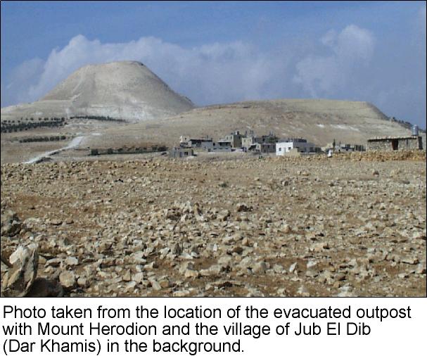
The 'Illegal' Outposts
In a bid to show that its policy is different from that of the preceding government, Barak's government revised the status of 42 (independent sources report 45) colonial outposts established after the signing of the Wye River Memo. The military establishment had advised Barak to dismantle 15 of the 42 outposts since they had legal problems:
-
8 outposts had proper permits,
-
27 had improper or incomplete permits,
-
7 had no permits at all.
Nevertheless, on October 13th a compromise was reached between the government and the Yesha council (speaking on behalf of the colonists) over the fate of those outposts. The number of outposts slated for removal were narrowed down to ten of which:
-
5 were empty or unmanned sites (i.e. containers or water tanks),
-
3 relocated to nearby sites,
-
2 to be evacuated at a later time.
-
Thus 32 outposts remained.
Table 9: Survey of Colony Outposts 1996 – 1999
|
# |
Mother Colony |
Outpost |
Structures on Site |
|
1 |
Avnei Hefetz |
(Eastern Caravans) |
18 |
|
2 |
Itamar |
Gidonim |
29 |
|
3 |
|
Gidonim A (Hill 851) |
23 |
|
4 |
|
Gvaot Olamn (Avri Ran's Farm) |
8 |
|
5 |
|
Hil Neighborhood (Hill 777) |
7 |
|
6 |
|
Hill 782 |
5 |
|
7 |
Elkana |
Magen Dan |
18 |
|
8 |
Elon More |
Har Kabir |
2 |
|
9 |
Allon Shevut |
Givat Ha'hish |
7 |
|
10 |
Bracha |
Bracha A |
19 |
|
11 |
|
Sneh Ya'akov |
3 |
|
12 |
Bet Ain |
Bet Ain B |
20 |
|
13 |
Halamish |
Zofit Farm |
25 |
|
14 |
Talmon South |
(Eastern Caravans) |
38 |
|
15 |
Talmon North |
Horesh Yaron |
20 |
|
16 |
|
Haresha |
17 |
|
17 |
|
Zayit Ra'anan |
1 |
|
18 |
Yizhar |
Eastern Hill |
14 |
|
19 |
|
Ahuzat Shalhevet |
4 |
|
20 |
Kokhav haShahar |
Mizpe Keramim |
11 |
|
21 |
El David |
Sdeh Bar Farm |
16 |
|
22 |
Maon |
Misgav Dov Neighborhood |
6 |
|
23 |
|
Maon Farm |
6 |
|
24 |
Maale Mikhmas |
Mizpe Dani |
15 |
|
25 |
|
Mizpe Hagit |
7 |
|
26 |
|
Neve Erez |
8 |
|
27 |
Ma'ale Amos |
Ivei Ha'nachal |
29 |
|
28 |
Susiya |
Magen David Farm |
4 |
|
29 |
Mezadot Yehuda |
Nof Nesher |
6 |
|
30 |
Tene Omarim |
(South Eastern Caravans) |
7 |
|
31 |
|
(Northern Caravans) |
9 |
|
32 |
Eli |
Nof Harim |
41 |
|
33 |
|
Ha'yovel Neighborhood |
12 |
|
34 |
|
Mizpe Shuna |
2 |
|
35 |
Ofra |
Amona |
17 |
|
36 |
Kedumim |
Har Hemed |
18 |
|
37 |
Karne Shomron |
Nof Kane Farm |
11 |
|
38 |
Shevut Rachel |
Ahiya (Hill D) |
15 |
|
39 |
|
Adi Ad (Hill F, Hill 799) |
11 |
|
40 |
Shilo |
Givat Harel (Hill 740) |
12 |
|
41 |
Kfar Tapuah |
Hill 660 |
1 |
|
42 |
Shevut Rachel |
Hill 804 |
N/A |
|
43 |
|
Hill 827 |
N/A |
|
44 |
Kiryat Arba |
Site 26 |
N/A |
|
45 |
|
Site 5152 |
N/A |
Source: Data compiled from Survey of Illegal Outposts 1996-1999, Peace Now, October 1999 and Colony Outposts Established During The Likud Party , Arab Studies Society, 1999.
Conclusion
The Barak government came to power with the promise of achieving peace. At first glance the actions of that government give the impression of working for peace. However, the government's policies were not whole-hearted nor were they free of any illusions. Just after signing the Sharm El-Sheikh Memo, 16 military orders were issued closing off large areas of land. The government announced a revision of the status of 42 outposts built under the previous government only to fix 32 of them while the media's attention is diverted to the removal of one. The rate of housing units approved was faster than that of the previous governments.
Israel continues to violate Palestinian rights (be it political, financial, civil, or human) as the last thirty-three years of killing, arrest, colonizing, and house demolishing stand witness to. Up to today, Palestinians in the West Bank are suffering from the discriminatory and brutal policies practiced by the successive Israeli governments. This is the situation despite the fact that it has been almost seven years since the start of the peace process in Madrid and six years since the signing of the Declaration of Principals.
Prepared by:
The Applied Research Institute – Jerusalem

&


