Since the signing of the Wye River Memorandum on 23 October 1998, the Israeli government has allowed the construction and expansion of new and existing Jewish settlements and have confiscated over 11,000 dunums (1 dunum = 1/10 hectare) of land within the West Bank and Gaza Strip. These unilateral actions are against the word and the spirit of the Wye Agreement.
Article V of the Wye Agreement on Unilateral Actions states: 'Recognizing the necessity to create a positive environment for the negotiations, neither side shall initiate or take any step that will change the status of the West Bank and the Gaza Strip in accordance with the Interim Agreement.'
According to Mossi Raz, from Peace Now, there have been 6 new illegal settlements erected since the signing of the Agreement up until November 9th. One of these illegal settlements is being called Giv'at Harel.
Creation of a New Illegal Settlement
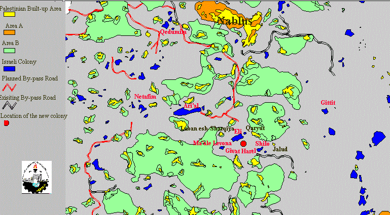
ShoLTRy after the signing of the Agreement, three settler families moved onto Palestinian land belonging to Sinjel village south of Nablus in the West Bank with three trailers and a water tower, and declared it Givat Harel (Figure 1, Figure 2) .
Figure 1: Map showing the location of the new colony Giv'at Harel.
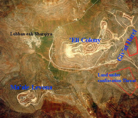
Figure 2: Aerial photo of the new colony.
This is a common beginning for settlements, many of which are now sprawling housing developments at the expense of large tracts of Palestinian land.(Figure 3)
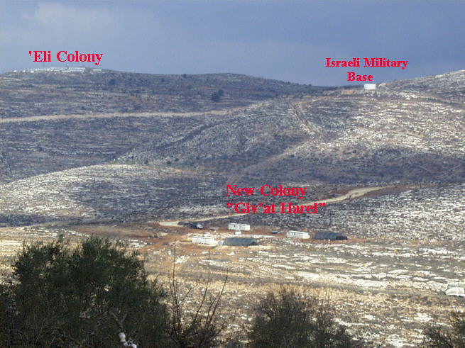
Figure 3: Colonists' carvans on Sinjel Land.
This illegal settlement is located on 4,000 dunums of land belonging to the Palestinian village of Sinjel. Confiscation orders for this land were distributed in 1988. The Palestinian Land Defense Committee took this issue to the Israeli Supreme Court and had the confiscation order detracted for much of the land.
Sinjel is already surrounded by the three settlements of Shilo, Eli, and Maale Levona, and by a new by-pass road. This newly confiscated land was the only area available for Sinjel to grow.
Since 1967, 8,000 dunums of land have been confiscated from Sinjel, including the site of Maale Levona, and 11 houses have been demolished for this confiscation. This newly confiscated land threatens the uprooting of more than 1,000 trees. This area was selected because of its proximity to the three surrounding settlements Shilo , Levona and 'Eli.
A large strip of land between the West Bank Palestinian cities of Nablus and Ramallah is dotted with Israeli settlements from East to West. A long line of these settlements is clearly visible from Sinjel on the tops of the surrounding hills. These settlements serve the Israeli purpose of cutting off Palestinians in Ramallah from their family and friends to the North, and, thus, further the segregation of Palestinian land.
By-Pass Road Expansion Steals more Land
The Palestinian village of Al-Khader is situated 8 kilometers south of Bethlehem city with a population of 6,800 (Figure 4). The original area of the village was 22,000 dunums, but, since 1967, 55% of this area has been confiscated by the Israeli authorities to build more illegal colonies or to construct by-pass roads.
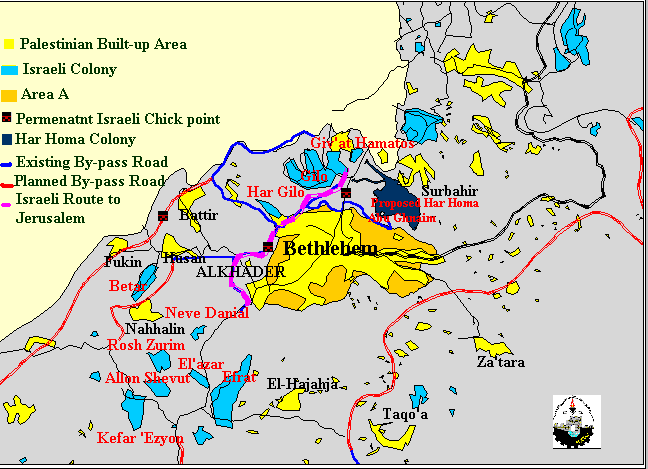
Figure 4: Location map for Al-Khader village.
Currently, Al-Khader village is under increasing threat from the expansion of road 60 (Figure 5). This expansion will add 3 km of road with a width of 35 m, plus the requisite 75 m buffer zone on either side of the road. 4,000 dunums of Al-Khader land will be completely destroyed due to this construction, whereas another 1,000 dunums will be lost to the buffer zone. More than 10,000 trees will be uprooted and 500 dunums of agricultural land will be bulldozed by the Israelis (Figure 6).
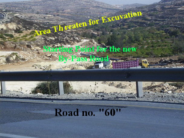
Figure 5: Close proximity of the new by-pass road to Road 60.

Figure 6: The threatened agricultural land.
The reason for this expansion, according to Israeli Civil administration officials, is to open an additional entrance for Efrat colony. They claim that Efrat colony has only one entrance, and is therefore at risk of being cut off in an emergency. Aerial photos of the colony, however, clearly show that Efrat already has two entrances (Figure 7). The true purpose of this new by-pass road then is to claim all of the land surrounding it for colony purposes. The methods used for this confiscation include using land previously declared as a buffer zone or for security purposes.
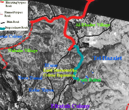
Figure 7: Satellite image of Al Khader village and Efrat colony.
Al-Khader is bordered by the Gush Etzion block of colonies. Around 50% of Gush Etzion block is built on land originally belonging to the village. This includes Efrat, El'Azar, 'Atzion, Neve Danial, and the new colony Tel Hazaiet.
Through the recent expansion of colonies and by-pass roads, and the restriction and confiscation of Palestinian land, the Israeli authorities have violated the Wye River Peace Agreement (1998). The confiscation of Al-Khader land for the enlargement of road 60 is thus illegal, but the Israeli government ignores this.
Settlement Expansion Threatens the Environment
On November 16, several new caravans appeared overnight near the industrial settlement of Halmish north of Ramallah (Figure 8, Figure 9). Another 500 dunums of Palestinian land belonging to the village of Nabi Saleh were used for this settlement expansion. Huddled close to the former Jordanian police station prior to 1967, this new construction occurred in the wake of statements by the Israeli Minister of External Affairs Ariel Sharon that every hill in Palestine was going to have a settlement upon it.
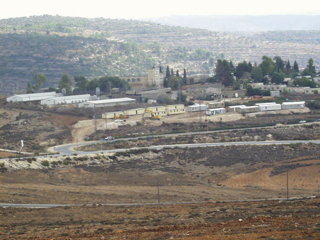
Figure 8: New caravans and construction activity at Halmish colony.
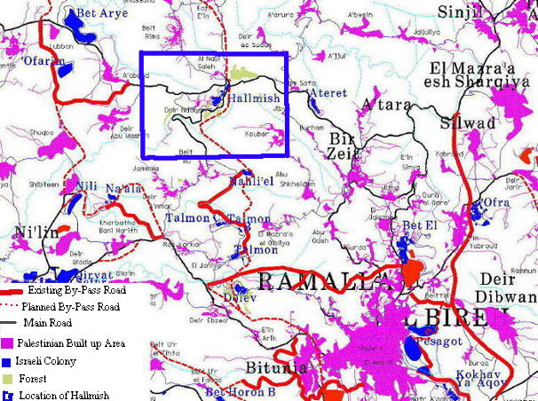
Figure 9: Location map of the Halmish colony.
Israeli construction crews have been observed working in this area only at night over the last month. One local resident believes this is because the land has not been legally obtained, and they are therefore trying to be inconspicuous about their activities. These days they build in broad daylight. Photos taken in July of 1997 show the changes that have occurred in this short period of time (Figure 10, Figure 11). Today, two rows of large houses overlook Nabi Saleh from the settlement . These have been under construction for the past year, and are still incomplete and uninhabited (Figure 12). A new by-pass road, also from this year, lies in front of them. A planned by-pass road linking Israeli colonies from north to south will run to the east of Halmish, and any further expansion of the colony is expected to encroach on more village land.
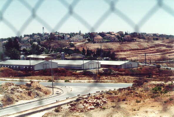
Figure 10: Halmish industrial area prior to the construction of new caravans.
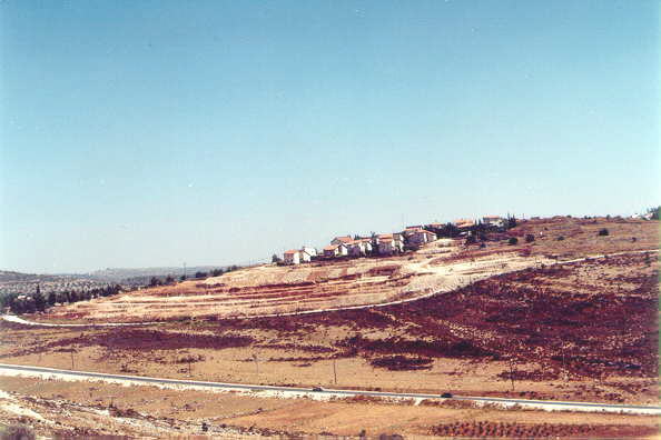
Figure 11: Halmish in July of 1997.
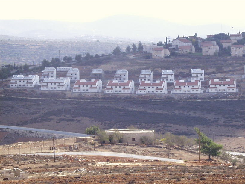
Figure 12: Rows of large, unoccupied houses at Halmish colony.
Established in 1977, Halmish colony has been notorious for dumping industrial wastewater on Palestinian agricultural land . Several industries are visible in the colony. This includes a large tanning factory that backs onto a Palestinian nature reserve and several chicken farms. Many olive trees, the main means of living in the nearby Palestinian villages, have been damaged by this industrial waste. The location of these new caravans next to the other settler industries suggests that they will be used for even more industrial activity.
These are just three of many examples of Israeli defiance of the Wye Agreement:
-
A new settlement called Um Al Akhwass was created in the eastern part of Yatta.
-
A Palestinian hill outside of Bethlehem was claimed by settlers from Gush Etzion.
-
Gavat Horshen settlement was established near the existing settlements of Dolev and Talmonim, northwest of Ramallah.
-
The settlement of Givat Hahesh was created near Allon Spot, southwest of Bethlehem.
-
Matzpe Dume settlement was created on Palestinian land near Ma'ale Muhmas.
-
Mobile homes have been erected on Palestinian land in Der Bain, Avnai Hafetz in the Tulkarem area, Alfei Menashe south of Nablus, and near Qadumim in the Nablus area.
-
Settlement expansion has gone underway in Eli, Ataret Kohanim, Kiryat Arba', and many areas surrounding Eat Jerusalem.
-
1,000's of dunums of land have been confiscated in the West Bank and Gaza Strip.
-
Several by-pass roads are being built and expanded upon, including a road linking Ibal with settlements in the Jordan Valley, a road connecting Karme Tzor with Route 60, the enlargement of the Trans-Samaria Road, and a by-pass road connecting Abu Gnaim with Route #20.
The last by-pass road is for the connection of the main road into Jerusalem with a settlement that does not exist yet. The construction of Har Homa settlement on Abu Gnaim mountain north of Bethlehem has been a major controversy for years. The Israeli Government has recently agreed to the construction of this settlement and has put out tenders for its construction. The November 6 car bomb explosion in West Jerusalem not only delayed the approval of the Wye Agreement by the Israeli Knesset for the fourth time, but it gave Prime Minister Netanyahu the excuse to allow the construction of the infamous Har Homa settlement, along with many other unilateral actions within the Palestinian Territories.
Each one of these actions are in clear violation of the letter and the essence of the Wye River Agreement. This disregard of yet another international Agreement signed and agreed to by the State of Israel clearly shows the true intentions of this State towards the Occupied Palestinian Territories.
Prepared by:
The Applied Research Institute – Jerusalem


