• About The Project
  • Palestine in Century
  • Selected Maps
  • Glossary
  • About ARIJ
  • About LRC
  • By Year
    • Case Studies By Year
    • Daily Report By Year
Thursday, May 29, 2025
POICA
No Result
View All Result
  • Home
  • Settlements
    • New Israeli Settlements
    • Settlement Expansion
  • Israeli Violations
    • Agriculture
    • Confiscation
    • Demolition
    • Environment
    • Eviction of Palestinians
    • Settlers Attacks
  • Bypass Roads
  • Israeli Plans
  • Segregation
    • Checkpoints
    • Closure
    • Separation Plans
  • Military Orders
  • Reports
    • Daily Report
    • Monthly Report
    • Quarterly Report
No Result
View All Result
POICA
No Result
View All Result

The Expropriation of Jalud’s Lands
Towards the Buntustanization of the West Bank

December 28, 1997
in Confiscation
The Expropriation of Jalud’s Lands  Towards the Buntustanization of the West Bank


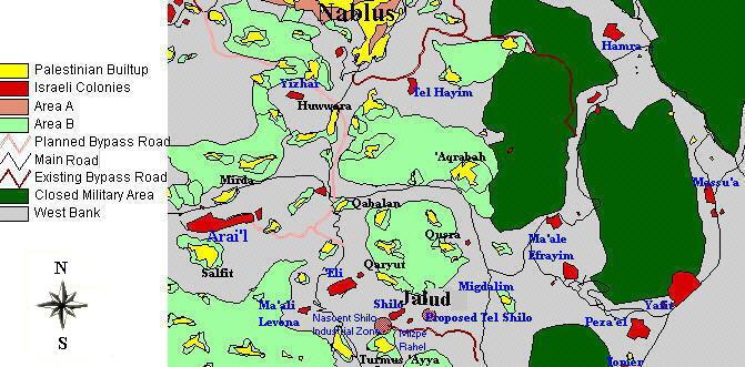
Jalud is a small Palestinian agricultural village spreading over an area of 4,000 acres. It is located 16 miles from the Palestinian city of Nablus (Figure 1). Since 1967, Jalud has been subjected to a continuous wave of aggression by the Israeli occupying authority. In 1992, 750 acres were confiscated from Jalud and the nearby village of Turmus ’Ayya to construct an industrial zone to serve the nearby colonies (Figure 2).). Since 1967, Jalud has been subjected to a continuous wave of aggression by the Israeli occupying authority. In 1992, 750 acres were confiscated from Jalud and the nearby village of Turmus ’Ayya to construct an industrial zone to serve the nearby colonies ().

In November 1996, hundreds of acres of agricultural land belonging to the Palestinian villages of Jalud and Qaryut were bulldozed. More recently, three hundred fruit trees have been uprooted to facilitate the construction of a road to primarily serve Jewish colonists. So far, two colonies called Shillo and Mizpe Rahil have been constructed on Jalud's cultivated land. A new proposed colony, called Tel Shillo, is to be constructed on Jalud's land at a location south of Shillo. The expropriation of Jalud's agricultural land for the purpose of building Israeli colonies and their infrastructure is part of a comprehensive plan by Israel to retain control over the west central parts of the West Bank, in an attempt to create a wall of colonies that would separate The Ramallah District in the central parts of the West Bank from Nablus in the north.

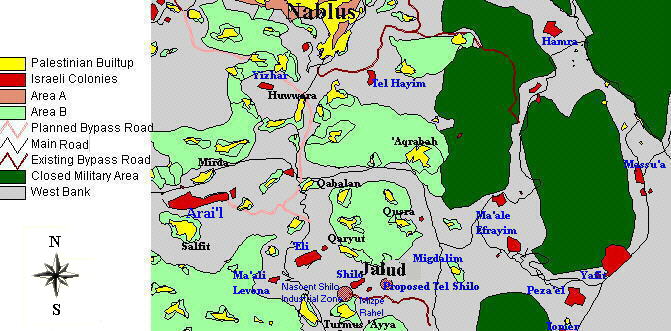
Figure 1: Location map of Jalud


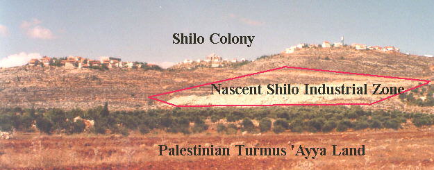
Figure 2: Photo illustrating the Israeli activities on the land of Jalud and Turmus ‘Ayya.


The new colony of Tel Shillo will be an independent colony in its own. The construction of this colony has already led to the confiscation of more than 1,000 acres of land belonging to the village of Jalud. Additionally, around 500 trees were uprooted from the nearby village of Qaryut to make space for a road to service this colony. Tel Shillo will be a stumbling block for the development of the surrounding Palestinian areas; its location hinders the geographical contiguity of the occupied Palestinian territories.

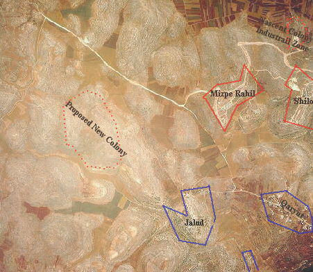
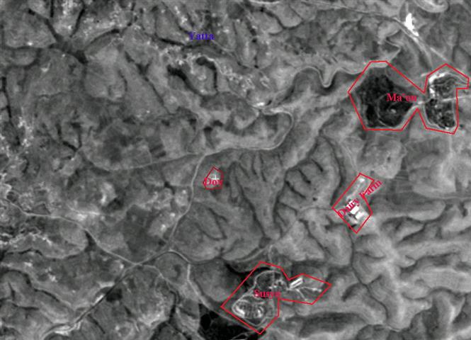
Figure 3: Aerial photo showing the location of the new proposed colony Tel Shillo


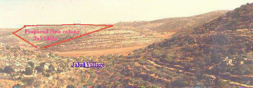
Figure 4: Photo showing the location of Tel Shillo close to Jalud village.


In sum, the colonizing activities in and around Jalud are part of an Israeli scheme in the occupied Palestinian territories to build a wall of colonies which would disconnect the southern parts of the West Bank from its northern parts (Figure 1). This scheme aims at creating a linkage between the Israeli colonies southwest of Nablus with one another and with Ma’ale Levona colony on Lubban road and the neighboring colony of Eli, further extending to Shillo, Rachelim, Migdalim and Ma’ale Efraym on the borders of the Jordan Valley. The land continuity between Ramallah and Nablus Districts will therefore be lost, thus isolating the northern parts from the remaining parts of the West Bank (Figure 5). This scheme will place Palestinian cities and villages in buntustans with access to each other only through Israeli controlled territories. The bird’s eye view of the geographical distribution of these colonizing activities indicates the construction of this wall of colonies extending horizontally across the borders of the West Bank (Figure 6). Such a scheme is another unilateral act by Israel which jeopardizes the progress of the peace talks and manipulates the outcome of the final status negotiations. Such schemes dictate Israel's will and compromise the Palestinians' legitimate right to a Palestinian State in which individuals are able to travel around without any restrictions. ). This scheme aims at creating a linkage between the Israeli colonies southwest of Nablus with one another and with Ma’ale Levona colony on Lubban road and the neighboring colony of Eli, further extending to Shillo, Rachelim, Migdalim and Ma’ale Efraym on the borders of the Jordan Valley. The land continuity between Ramallah and Nablus Districts will therefore be lost, thus isolating the northern parts from the remaining parts of the West Bank (). This scheme will place Palestinian cities and villages in buntustans with access to each other only through Israeli controlled territories. The bird’s eye view of the geographical distribution of these colonizing activities indicates the construction of this wall of colonies extending horizontally across the borders of the West Bank (). Such a scheme is another unilateral act by Israel which jeopardizes the progress of the peace talks and manipulates the outcome of the final status negotiations. Such schemes dictate Israel's will and compromise the Palestinians' legitimate right to a Palestinian State in which individuals are able to travel around without any restrictions.

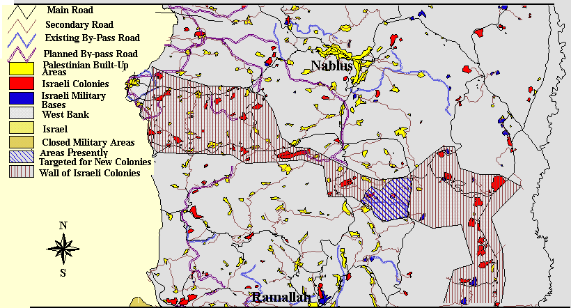
Figure 5: Map showing the wall of colonies in the center of the West Bank.


Figure 6: Satellite image showing the continuity of the Israeli colonies in a horizontal line.


Prepared by:
The Applied Research Institute – Jerusalem

Recommended For You

هدم وسرقة بيت تعبئة زراعي في كردلة – ضربة موجعة للاقتصاد المحلي

by arij
January 21, 2025
0
Demolition and Theft of an Agricultural Packing Facility in Kardala: A Severe Blow to the Local Economy

تفاصيل الانتهاك: منذ احتلال الضفة الغربية عام 1967، باتت قرية كردلة هدفًا رئيسيًا للاحتلال الإسرائيلي الذي يسعى بكل الوسائل لتفريغها من سكانها الأصليين، تمهيدًا للاستيلاء على أراضيها ومواردها....

Read moreDetails

Demolition and Theft of an Agricultural Packing Facility in Kardala: A Severe Blow to the Local Economy

by arij
January 20, 2025
0
Demolition and Theft of an Agricultural Packing Facility in Kardala: A Severe Blow to the Local Economy

Since the occupation of the West Bank in 1967, the village of Kardala has become on the list of the prime and major targets for the Israeli occupation,...

Read moreDetails

تستهدف ما يزيد عن6900, تسجيل الأراضي في القدس في خدمة مشروع الاستيطان الإسرائيلي وشرعنة الاستيلاء على الأرض

by arij
May 8, 2023
0
POSITION PAPER: A Land Mine before the “Two State Solution

   تسوية الأراضي هي أحدى اهم حيل إسرائيل لتهويد القدس الشرقية، وقد كان القضاء الإسرائيلي قد أصدر إعلاناً عن بدء "تسوية أراضٍ" بمسميات وأرقام جديدة للأحواض في احياء...

Read moreDetails

الاحتلال يصادر محتويات منتزه في جبل السنداس جنوب مدينة الخليل

by arij
September 14, 2022
0
الاحتلال يصادر محتويات منتزه في جبل السنداس جنوب مدينة الخليل

  الانتهاك: مصادرة مواد منتزه. تاريخ الانتهاك: 31/08/2022. الموقع: جبل السنداس/ مدينة الخليل. الجهة المعتدية: الإدارة المدنية التابعة للإحتلال. الجهة المتضررة: المواطن يسري الجمل. التفاصيل: أقدمت سلطات الاحتلال...

Read moreDetails

The Occupation Confiscates Properties of a Park Owner at Hebron City

by arij
September 15, 2022
0
الاحتلال يصادر محتويات منتزه في جبل السنداس جنوب مدينة الخليل

  Violation: Confiscation of park properties. Date: August 31st 2022. Location: As-Sindas Mountain / Hebron city. Perpetrators: The Israeli Civil Administration. Victims: Citizen Yusri Aj-Jamal. Description: Wednesday ,...

Read moreDetails
Next Post
Ethnic Cleansing in Palestine  Yatta as a Case Study !!!

Ethnic Cleansing in Palestine
Yatta as a Case Study !!!

LATEST NEWS

Expansion of Gilo Settlement: A Strategic Plan to Isolate Bethlehem and Undermine Palestinian Rights

Expansion of Gilo Settlement: A Strategic Plan to Isolate Bethlehem and Undermine Palestinian Rights

by arij
May 12, 2025
0

........................................................

الأراضي الفلسطينية بين الذرائع الأمنية والأطماع الاستيطانية – “الأمن، الآثار، والطبيعة كحجج لاقتلاع الفلسطينيين من أراضيهم”

by arij
April 15, 2025
0

........................................................

الطرق الالتفافية الاسرائيلية وأثرها على البيئة الفلسطينية

انتهاك للطبيعة والهوية في الأراضي الفلسطينية المحتلة

by arij
March 17, 2025
0

........................................................

Israel Advances Settlement Plan on Ancient Olive Groves on lands of Beit Jala city, Violating International Law and depriving Palestinians their lands

إسرائيل تمضي قدمًا في مخطط استيطاني جديد على أراضي مدينة بيت جالا، في انتهاك للقانون الدولي وحرمان الفلسطينيين من أراضيهم

by arij
April 29, 2025
0

........................................................

flag_yellow_lowEU-PfP-Logo

This website has been produced with the assistance of the European Union. The contents of this publication are the sole responsibility of ARIJ & LRC and can in no way be taken to reflect the views of the European Union.

© 2025 Copyright ARIJ . All Rights reserved. .

No Result
View All Result
  • Home
  • Settlements
    • New Israeli Settlements
    • Settlement Expansion
  • Israeli Violations
    • Agriculture
    • Confiscation
    • Demolition
    • Environment
    • Eviction of Palestinians
    • Settlers Attacks
  • Bypass Roads
  • Israeli Plans
  • Segregation
    • Checkpoints
    • Closure
    • Separation Plans
  • Military Orders
  • Reports
    • Daily Report
    • Monthly Report
    • Quarterly Report

© 2025 Copyright ARIJ . All Rights reserved. .