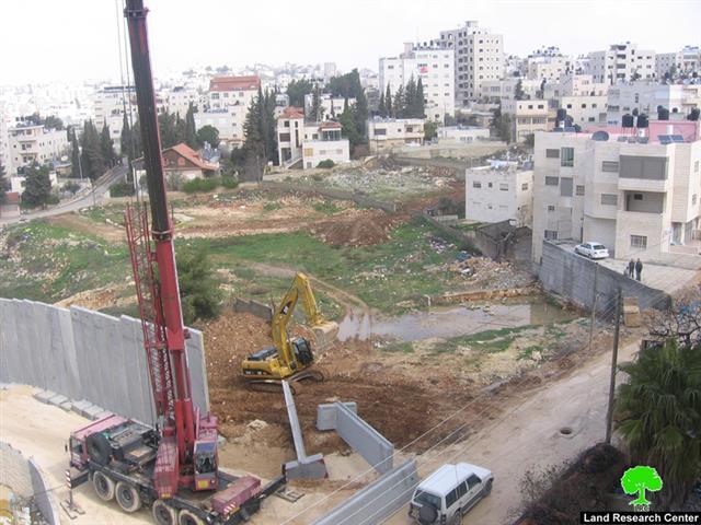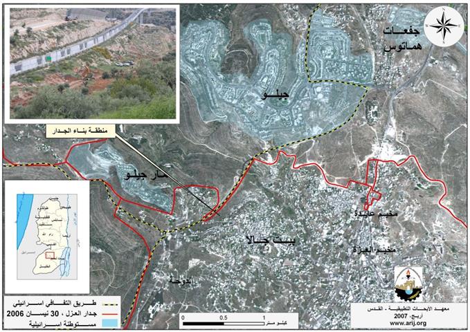
الجرافات الاسرائيلية تستكمل بناء جدار العزل العنصري في مدينة بيت جالا
شرعت قوات الاحتلال الاسرائيلي بتجريف مساحات جديدة من اراضي مدينة بيت جالا لغرض بناء جدار العزل في المدينة. ...
شرعت قوات الاحتلال الاسرائيلي بتجريف مساحات جديدة من اراضي مدينة بيت جالا لغرض بناء جدار العزل في المدينة. ...
(Photo1 : in the foreground are the ruins of the house of Mustafa Abu Dayyeh; in the background is the ...
This report highlights the chronology of events concerning the Israeli Colonizing Activities in the West Bank, Jerusalem and the Gaza ...
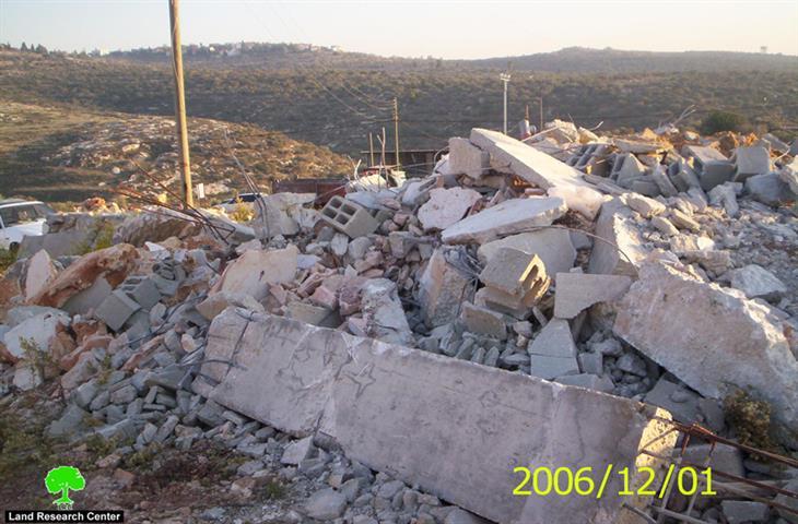
On February 21, 2007, the Israeli occupation Army distributed 12 demolition notices for structures belonging to residents of Beit Sakariya ...
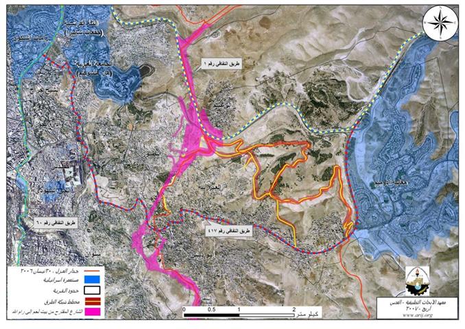
The Israeli occupation authorities continue to commit more crimes against Palestinian citizens, lands, houses and properties in Jerusalem in violation ...
On 2/4/2007, at 3:30 AM, an Israeli military force comprised of border guard police and intelligence personnel accompanied with civilian ...
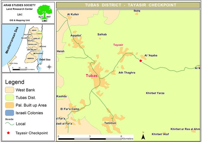
Tayasir military Checkpoint It that was established near the Jordan Valley at the outset of the Second Intifada. It is ...
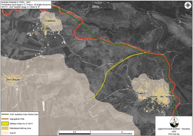
Palestinian residents of Faqqu'a village west of Jenin city received through registered mail 17 military orders sent to them by ...
إن انهيار السد الترابي لأحواض المياه العادمة في قرية أم النصر شمال قطاع غزة في السابع و الشرين من شهر ...
In an unprecedented step aiming at obstructing the mission of the newly formed Palestinian Government and the peace process, the ...
On February 6, 2007, the Israeli army handed out 'Aboud village council a new military order stating the confiscation of ...
في خطوة اسرائلية رامية الى عر قلة عمل حكومة الوحدة الوطنية الجديدة ووضع العراقيل امام اعادة احياء عملية ...
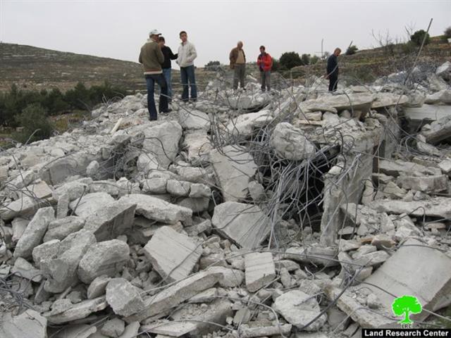
(Photo 1: Ar Ramuz quarter, Halhul: the ruins of the house of Mr. Ibrahim Abu Yusif) On ...
نشرت حركة 'السلام الآن' الاسرائيلية تقرير جديد على صفحتها الالكترونية بتاريخ 14/3/2007 و الذي اشارت فيه الى أن 32% ...
On March 3rd, 2007, the Israeli occupation authorities issued a military decree signed by the legal advisor to the ...
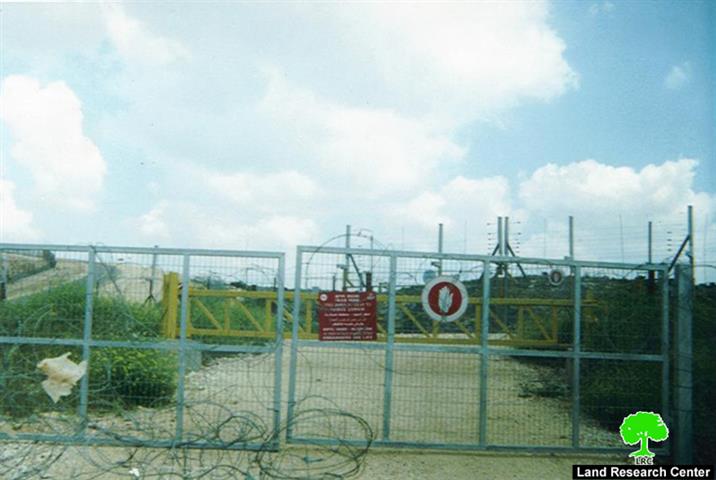
(Photo 1: Ar ras village-Tulkarem: the closed agricultural Wall Gate to the west of the village) The Israeli occupation authorities ...
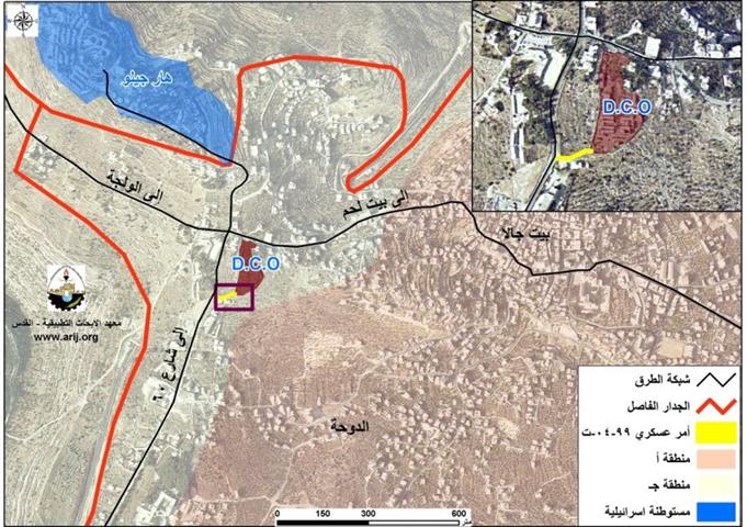
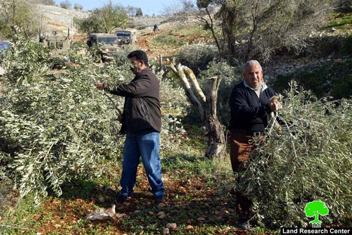
سلمت قوات الاحتلال الاسرائيلي أهالي مدينة بيت جالا تمديدا للأمر العسكري رقم 99/04/ ت و الذي كان قد ...
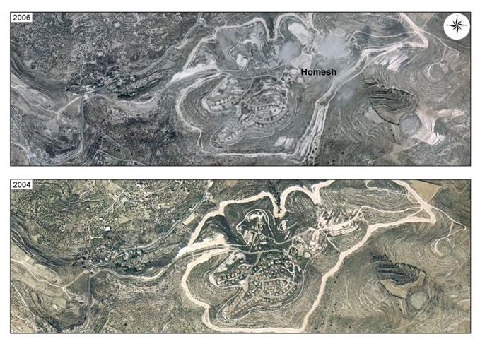
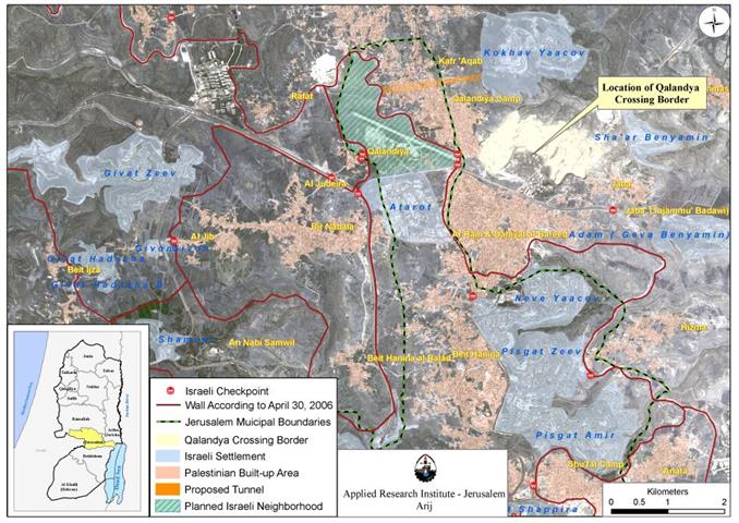
On the February 28, 2007, the Israeli daily newspaper 'Haaretz' published on its website a plan submitted by the Israeli ...
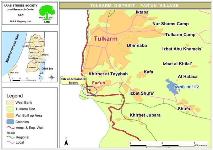
Introduction about Far'on: The village of Far'on is located north of the city of Al Tayeba in the Triangle ...
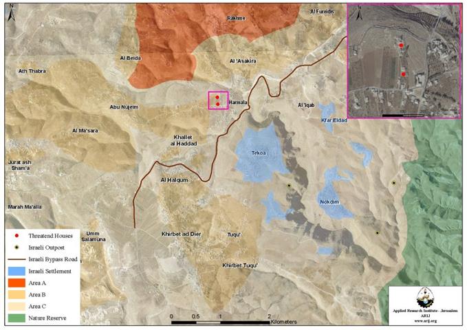
On February 15, 2007, the Israeli Occupation Army handed out two Palestinian residents in Harmala village military notifications to halt ...
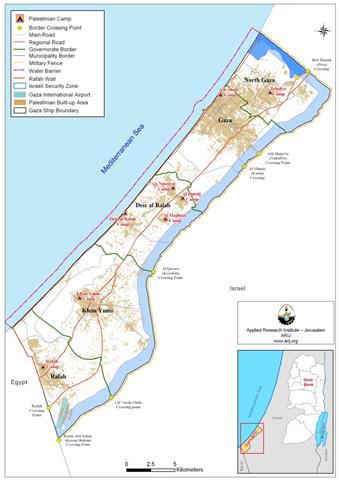
Introduction In a controversial step, the Israeli occupation government declared the four Gazan Terminals linking Gaza Strip with the West ...
The Israeli occupation forces started at the beginning of last month to prevent Kafr Laqif's farmers, Qalqiliya, from accessing into ...
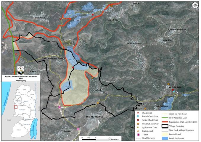
The Israeli occupation army issued a new military order stating the confiscation of 404 dunums and 600 squarer ...
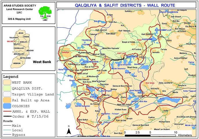
بدأت اسرائيل بتنفيذ مخطط نظام عزل الشوارع العنصري الذي أعلنت عنه في شهر تشرين أول من عام ...
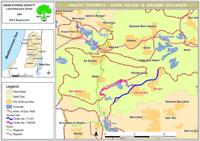
(Photo 1: Deir Ballut-Salfit: olive trees' owners inspecting the size of damage) At the end of January, 2007, ...

........................................................

........................................................

........................................................

........................................................

This website and its content were initiated in 1993 by the Applied Research Institute – Jerusalem (ARIJ) and the Land Research Center (LRC) with the support from the European Union up until 2023. Since then, the Applied Research Institute – Jerusalem (ARIJ) has taken over the continued development and maintenance of the website. The views expressed remain solely those of ARIJ) and do not necessarily reflect those of the European Union.