On 10 August, 2025, the Israeli Civil Administration (ICA), issued a booklet of military orders signed by the head of the so-called ‘Israeli Civil Administration’ in the occupied West Bank, Brigadier General Moti Almoz, under the title, “Order Regarding the Antiquities Law (Judea and Samaria) (No. 6611–6891) of 1986 – Notice Regarding the Antiquities Law (Judea and Samaria) of 2013, No. 3162”.
The orders stipulate the following: ‘By virtue of my authority as commissioner, under the Order Regarding the Antiquities Law (Judea and Samaria), (No. 6611–6891 of 1986), (hereinafter referred to as “the Order”), and pursuant to Article 8(a) of the Antiquities Law No. 16 of 1981 (hereinafter referred to as “the Law”), I hereby declare: “The following sites indicated on the maps are historical sites containing antiquities.”
Based on the maps provided in the orders’ booklet, 63 sites in the occupied West Bank were classified as ‘Israeli historical and archaeological sites,’ including 59 sites in Nablus Governorate alone, three sites in Ramallah Governorate, and one site in Salfit Governorate. Table (1) illustrates the distribution of the targeted sites in the occupied West Bank according to their locations.”
| Table No. 1: Archaeological sites targeted according to the Israeli booklet issued by the Israeli Civil Administration | |||
| Governorate | Location Name | Geographical Location | No. |
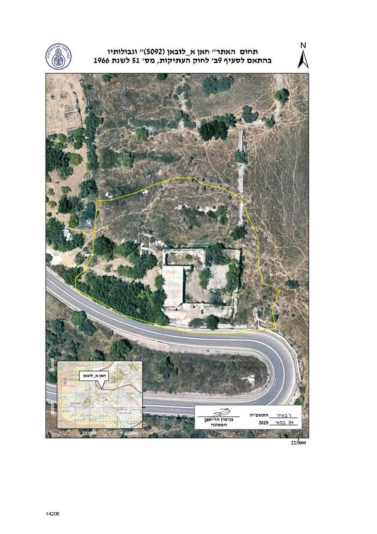
| Ramallah | Khan Al Laban | Near Maale Levona Settlement | 1 |
| Ramallah | Al Ouf | North Givat Ha’oreh Outpost | 2 |
| Nablus | Shilo | West of Shilo Settlement | 3 |
| Nablus | Kherbit Al Babariya | North Shavei Shomron Settlement | 4 |
| Nablus | Kherbit Tana At Tahta | Between Givat Arnon outpost and Mechora settlement | 5 |
| Nablus | Kherbit Sur | Northwest Shilo Settlement | 6 |
| Nablus | Kherbit As Sartasa | Near Ein Bizarya | 7 |
| Nablus | Al Masoudiya Train Station (Sebastyia) | East of Sebastyia Archeological site | 8 |
| Nablus | Al Kula | The military base of Eibal Mountain | 9 |
| Nablus | Kherbit Al Kanisa | East of the Israeli military post belonging to Mount Ebal | 10 |
| Nablus | Tel Ar Ras | East of Jirzim Mountain | 11 |
| Nablus | Jarzim Mountain | Jirzim Mountain | 12 |
| Nablus | Kherbit Ebn Nasr | South Adi Ad Outpost | 13 |
| Nablus | Kherbit Kafrur | Southeast Havat Gilad settlement outpost | 14 |
| Nablus | Kherbit An Nabi | Shomron Emergency Center – near the Giv’at Sneh Ya’akov settlement outpost | 15 |
| Nablus | Kherbit At Tira | East Yitzhar Settlement | 16 |
| Nablus | Kherbit Jarish | Southeast Yanun village | 17 |
| Nablus | Kherbit Mars Ad Din | West of Gittit | 18 |
| Nablus | Kherbit Ar Rahya | South of Duma Village | 19 |
| Nablus | Jabal Soboh | Southwest Avitar outpost | 20 |
| Nablus | As Safa | South of Israel ibypass Road No. 505 | 21 |
| Nablus | Kherbit An Nazla | In the heart of kfar Taphuh Settlement | 22 |
| Nablus | Al Hadaba | North of Majdal Bani Fadel village – Agricultural lands | 23 |
| Nablus | Shweika East | Northeast Beit Dajan village | 24 |
| Nablus | Al Kherbah | Southeast Shavei Shomron | 25 |
| Nablus | Kherbit Rafeed – West | South of Giv’at Harel settlement outpost | 26 |
| Nablus | Kherbit Rafeed | In the heart of Amichai settlement | 27 |
| Nablus | Kherbit Al Kura | North of Qabalan, alongside the Israeli bypass Road No. 505 to the south | 28 |
| Nablus | Amichai South | In the heart of Amichai settlement | 29 |
| Nablus | Amichai North | In the heart of Amichai settlement | 30 |
| Nablus | Khallet Shayeb | North of bypass road No. 55 | 31 |
| Nablus | Kherbit Hayya | In the heart of Itamar settlement | 32 |
| Nablus | Kherbit Al Bab | Alongside the Israeli, bypass Road No. 60 | 33 |
| Nablus | Kherbit Jabal Al Bad | 34 | |
| Nablus | Kherbit Ash Sheikh Ahmad At Ta’ban | West of Bracha | 35 |
| Nablus | Ash Sheikh Salman Al Farsi | In the Heart of Bracha settlement | 36 |
| Nablus | Kherbit Halas | North of Yetzhar settlement | 37 |
| Nablus | Kherbit Sharb | Southwest of Itamar | 38 |
| Nablus | Kherbit Ghanam | Northwest of Giv’at Arnon outpost (the site is occupied by an outposts where some caravans ar41e in the place | 39 |
| Nablus | An Nabi Nun | South of Givat Arnon outpost | 40 |
| Nablus | Ras Az Zeid | South of Huwwara | 41 |
| Nablus | Kherbit An Najma | Northeast of Migdalim settlement | 42 |
| Nablus | Kherbit As Suya | North of Eli settlement – near an existing Israeli outpost. | 43 |
| Nablus | Eli 1 | In the heart of Eli Settlement | 44 |
| Nablus | Kherbit Nejmet Khneifets | Northwest of Amichai settlement | 45 |
| Nablus | Kherbit Birkat Al Qasr | South of Esh Kodesh outpost | 46 |
| Nablus | Elevation Point 474 (5109) | East of Aqraba village– open area | 47 |
| Nablus | Ash Sheikh Bilal | North of Elon Moreh | 48 |
| Nablus | Elevation Point 775 (5125) | West of an Existing Outpost | 49 |
| Nablus | Kherbit Al Marjam | East Kida outpost | 50 |
| Nablus | Al Ein Al Kabeera 5133 | West of Elon Moreh, near an existing outpost | 51 |
| Nablus | Elevation Point 432 | East of Aqraba village” – in an area classified as Nature Reserve | 52 |
| Nablus | Kherbit Sharab | East of Itamar | 53 |
| Ramallah | Beir Al Batin | Northeast of Maale Levona | 54 |
| Nablus | Kherbit As Surra, South | In the heart of Shilo settlement | 55 |
| Nablus | Kherbit As Saleeb | South of Bracha settlement | 56 |
| Nablus | Iraq Az Zagh | Southeast of Kherbit Tana | 57 |
| Nablus | Wadi Ad Dabe’ Cave | Near Kherbit Al Mrajem | 58 |
| Nablus | Ras Al Janna | Along side Israeli Bypass Road 60 | 59 |
| Nablus | Kherbit Al Kura | Between Beita and Usarin village | 60 |
| Nablus | Eibal Mountain | Northwest of Askar | 61 |
| Nablus | Kherbit Al Aqeil | West of Sebastya | 62 |
| Nablus | Kherbit Kammounyia | East of Rechalim settlement | 63 |
Following Israel’s occupation of the Palestinian territory in 1967, authority over antiquities was entrusted to the Israeli military governor. The Jordanian Antiquities Law No. 51 of 1966 remained in force in the occupied West Bank, while the Palestinian Antiquities Regulations of 1929 remained applicable in Gaza. Under Israeli military rule, an Antiquities Department was established/created, headed by the Officer of Antiquities, who was subordinate to the Israeli military government and the Civil Administration.
In order to tighten its control over archaeological sites in the occupied West Bank, the Israeli occupation Authority introduced several amendments to the Jordanian Antiquities Law No. 51 of 1966 through a series of Israeli military orders. These included transferring the powers of the Director of Antiquities, as stipulated in the Jordanian law, to the Israeli military governor, as well as suspending the enforcement of certain provisions of the Jordanian law in force.
In 1986, the Israeli occupation authorities introduced extensive amendments to the Jordanian Antiquities Law through Military Orders No. 1166 and 1167. These amendments affected issues relating to licensing and trade of Palestinian antiquities.
Moreover, these Israeli military orders granted the Israeli Officer of Antiquities nearly absolute “legal” powers in the occupied Palestinian territory, thereby; tightening Israel’s grip over Palestinian archaeological resources, controlling and exploiting them as part of its “settlement project” in the Palestinian territory.
By virtue of my authority as Head of the Civil Administration in Judea and Samaria, and pursuant to Article 16 of the Order Regarding the Antiquities Law (Judea and Samaria) (No. 1166), 5746 – 1987, and Article 48 of the Antiquities Law No. 51 of 1966, I hereby issue the following regulations:
|
The military orders’ booklet also targeted 10 Israeli settlements in the occupied West Bank through ‘redefining/changing their boundaries’ under Israeli Military Order No. 892 of 1981, entitled: ‘Order Concerning the Administration of Local Councils (Judea and Samaria) No. 892, 5741-1981’, pursuant to which local councils were established for Israeli settlements in the occupied West Bank. The targeted Israeli settlements are listed below according to their location in each governorate, as shown in Table No. (2)
| Table 2:Targeted Israeli settlements as listed in the booklet of military orders | |||
| Settlement Name | Governorate | Military Order Use | No. |
| Tene Omarim | Hebron | Redefining/Changing | 1. |
| Nahliel | Ramallah | 2. | |
| Modin Illit | Ramallah | 3. | |
| Mateh Benyamin- Near Migron | Ramallah | 4. | |
| Givat Zeev | Jerusalem | 5. | |
| Maale Adumi | Jerusalem | 6. | |
| Kalyia – Dead Sea | Jerusalem | 7. | |
| Shaare Shomron | Qalqilyia | 8. | |
| Karnei Shomron | Qalqilyia | 9. | |
| Efrat | Bethlehem | 10. | |
In closing,
Israel’s targeting of Palestinian archaeological sites in the occupied West Bank is not merely a matter of “administrative” or “formal legal” procedures. Rather, it is part of a systematic policy aimed at confiscating Palestinian heritage and reshaping the Palestinian historical identity to serve the Israeli settlement project—especially given that the majority of the targeted sites are located near Israeli settlement outposts, settlements, or other military sites, particularly in Nablus Governorate.
Classifying these Palestinian archaeological and historical sites as “Israeli” constitutes a clear violation of international law, including the 1954 Hague Convention for the Protection of Cultural Property in the Event of Armed Conflict, and the Geneva Conventions, which prohibits an occupying power from altering the historical and cultural character of occupied territories or exploiting them for political or military purposes. Consequently, the Israeli occupation’s practices regarding Palestinian heritage constitute a blatant breach of international obligations and pose a direct threat to Palestinian national identity.
Instead of safeguarding and preserving cultural property as part of Palestinian heritage, the Israeli occupation authorities classify many Palestinian archaeological sites as “Israeli property” and use military orders to justify their control and legitimize their confiscation.
It is worth noting that the Israeli occupation authorities classify more than 2,400 Palestinian archaeological sites in the occupied West Bank as “Israeli archaeological sites,” declaring them areas that must be protected and preserved. In practice, however, these sites are used to control vast areas of Palestinian land under the pretext of “heritage preservation”. Many of these areas are later transferred for use of Israeli settlements, settlement outposts, military sites, or tourist and recreational facilities, from which only Israeli settlers and tourists benefit.
Prepared by:
The Applied Research Institute – Jerusalem