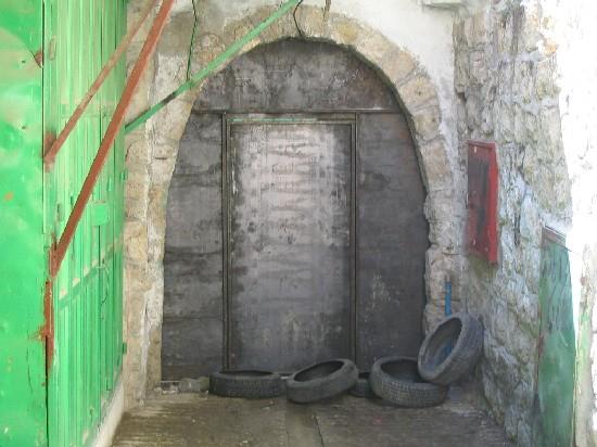
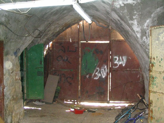
As a continuation of the policy of besieging the old city of Hebron, the Israeli army, at the beginning of last August erected seven new iron gates ( inner city gates) across roads inside the old city leading to the old Sug (Market place). The newly erected gates complete the encirclement of the old market and its 2500 inhabitants. It is worth mentioning that the old Sug is located within the larger area of what is called Hebron 2 – 20 % of Hebron city under the direct control of the Israeli army.
Photos 1, 2, & 3: three oput of the seven newly erected gates inside the
Old Suq of Hebron's old city- , , & : three oput of the seven newly erected gates inside the Old Suq of Hebron's old city- Photos courtesy of LRC)
The latest Israeli siege measures coupled with violent attacks by the Israeli colonists have caused critical humanitarian and economic situation for the Hebron 2 Palestinian citizens.

Map 1: Map of the old city of Hebron showing the Israeli
closures and settlement, including the newly erected city gates : Map of the old city of Hebron showing the Israeli closures and settlement, including the newly erected city gates
Introduction to Hebron
In January, 1997, the Hebron protocol was signed by Israeli and Palestinian Authority according to which the city was divided into Hebron 1 and 2. Hebron 2 covers approximately 20 % of the municipal territory. It comprises the entire Old Suq and areas adjacent to the Israeli colonies. The Protocol authorizes security and civil administration to the Israeli occupation in Hebron 2, while in Hebron 1 the Palestinian authority was given full security and civil administration. In 2002, the whole city was re-occupied by the Israeli army.
Once the centre of Hebron's commercial and cultural life, the old Suq is now virtually deserted. The city of Hebron is the second city after Jerusalem with Jewish colonies inside its urban area where there are about 600 colonists who live in the four colonies of Avraham Avino ( Old Market), Beit Rumano ( Usama Ben Al Mungiz School), Beit Hadassah ( Daboiya) and Ramat Yasha ( Tel Rumaida ). The Israeli colonists in Hebron are protected by more than 1500 Israeli soldiers and security men. On the other hand, there are two larger colonies whose population exceeds 7000 sit on the hills overlooking the Hebron's eastern quarters- Kiriayt Arab' and Givat Kharsina.
Hebron is the second largest city in the West Bank after Nablus with a population of 170 000 of which about 35000 live in Hebron 2.
Movement restriction in Hebron 2
The city of Hebron 2 is surrounded with checkpoints, road blocks and military barriers cutting roads leading to other parts of the city in Hebron 1 and even to other parts of Hebron 2 such as the only industrial zone in Al Fahs area. Farmers from around the city has no access to the city's old markets, including the vegetable market, gold market, yogurt market, leather market and others which have been under closure since the beginning of the current Intifada.
As of September, 2005, more than 82 closures of different kinds block Hebron 2 area, particularly the old city and Suq. Many of these block the exits from the Old Suq toward Al Shohada street or onto ' prayers road ' which was built for exclusive Jewish use from Kiriayt Arba' to Ibrahimi mosque ( for related information, see case study entitled ' Israeli ' Prayers' Road ' is being built on the ruins of ancient Palestinian houses – Old city of Hebron' Sep, 2005 ).
Photos 4, 5 & 6: Different types of closures in the old city of Hebron


Photos 7, 8 & 9: Different types of closures in the old city of Hebron
(Photo courtesy of LRC)
Restrictions on movement were imposed on Palestinians on all roads that run between, toward and adjacent to colonies. For instance, students from Cordoba school which is located on Al Shuhada street cannot use the main road (although rehabilitated by American money in the year 2000 on condition that it should be used by both Palestinians and Israelis) and have to take a detour around the southern side of the school across fields to avoid crossing the path of colonists along Al Shuhada street (see map above). ).
Out of the aforementioned closures, there are 14 checkpoints preventing Palestinians from driving or walking inside Hebron 2. Those who live beyond are required to be registered with the Israeli army to reach their homes. In an area called Wadi Al Gruz, for instance, a Palestinian quarter between the colonies of Kiriyat Arba' and Givat Kharsina, the combination of earth mounds, road blocks and gates has isolated about 65 families from the rest of the city.
Annexation and Expansion Wall
Construction works in the Annexation and Expansion Wall are under way in Wadi Al Gruz, Ein Bani Salim and Al Buweira areas located in between or around the two colonies of Kiriayt Araba' and Givat Kharsina. Hundreds of dunums of fertile vine yard, peach and apple groves have been devastated under the path of the Wall or seized behind it for future expansion of the two colonies. The construction of the Wall inside Palestinian agricultural lands in these areas meant that Palestinian farmers have either completely lost their lands or are required to pass through gates which necessitates prior coordination with the Israeli army and security apparatus to reach their lands. The most recent military order was issued last July stipulating the confiscation of land for the construction of a 6 km long road around the colony of Kiriayt Arba' to enlarge the 'security ' buffer zone around the colony.

Photo 10: a section of the Wall being built in Ein Bani Salim between
Kiriayt Arab'a and Givat Kharsina) – ( : a section of the Wall being built in Ein Bani Salim betweenKiriayt Arab'a and Givat Kharsina) – ( Photo courtesy of LRC ) )
More security roads
In addition, ' security ' roads were constructed to link the colonies of Kiriyat Araba' and Givat Kharsina to the Jewish colonies inside the old city of Hebron. One of these roads was already established in August, 2004, on the eastern side of the Ibrahimi mosque which led to the demolition of 11 Palestinian houses dating back to the Ottoman and Mamluk periods ( for related information see case study titled Israeli ' Prayers' Road ' is being built on the ruins of ancient Palestinian houses – Old city of Hebron, Sep. 2004). There are additional plans to build another road from the colony of Ramat Yashai ( Tel Rumaida) to the Ibrahimi mosque cutting through Hebron's Islamic cemetery ( for related information, see case study titled Israeli Colonists' road planned over ancient historical site in Hebron's Old City, February, 2005).
Closure on commercial activities and impact
The Israeli measures represented by military orders, prolonged curfews during 2001 and 2002, as well as colonists' violence have emptied the Old Suq of trade. Shopkeepers resort to back- to- back system of transportation (moving goods from one vehicle to another) at the gates to bring in goods. The wholesale and vegetable markets have been relocated from H2 to H1. According to the Palestinian Ministry of National Economy there were 1610 shops licensed in H2 before September, 2000. Currently, more than 1000 shops are closed, one third by military orders. According to Hebron Rehabilitation Committee, of the 650 shops and storage places still located in the Old Suq, just 10% are functioning.


Photos 11 & 12: Two streets in the Old Suq full of closed stores
& : Two streets in the Old Suq full of closed stores(Photo courtesy of LRC)
The aforementioned conditions have increased poverty in H2. According to a survey conducted by the Ministry of National Economy the average income per household in H2 is about NIS 700 per month which is well below the poverty line. The International Committee of the Red Cross initiated a monthly distribution of food parcels in 2002 to almost 2500 households in H2 that includes all of the Old Suq residents. It is the only food assistance program the ICRC still continues in the West Bank.
Colonists' violence
Israeli colonists continue their daily violent attacks against humans and properties inside the old city and in Wadi An Nasarah quarter for its proximity from Kiriayt Arba' colony. These continuous attacks are aimed at dismissing Palestinian families out of the area, particularly those living in the Old Suq and near the colonies. Metal netting has been erected above the sections of the Old Suq running under Avraham Avino colony and above the Old Shalala street running under Beit Hadasah ( Daboyia) colony from where colonists throw garbage, stones and empty bottles at the heads of passersby and store keepers in an act of continuous humiliation of human beings and as an attempt to discourage movement below.


Photos 13,14 & 15: Examples of the netting erected above the sections of the
Old Suq and old Shalala street to protect passersby and shop keepers.
(Photos courtesy of LRC)
Humanitarian effects of closure and violence
In the religious field, prayers have to pass through a series of iron metal detector gates upon entering into the mosque. This long process could take up to half an hour to reach the mosque. Prayers have to queue in lines in front of the gates and wait for permission from soldiers to enter into the gates for checking one by one. Some times, people are stuck inside the rolling gate waiting for the solider to press a button to allow access. This humiliating process only leads to an increase in the level of anger and tension amongst Palestinian prayers and residents of the area. In certain Jewish anniversaries and religious celebrations, the Ibrahimi Mosque Mu'azin (one who calls for praying) is prohibited from performing his task. Some times, this ban could last for many days and nights.
On the other hand, the Israeli occupation authorities stopped the Hebron rehabilitation Committee from doing any renovation and rehabilitation works inside the Ibrahimi mosque for no clear reasons.

Photos 16 & 17: people exiting the gates that lead to the mosque in the Old Suq area
& : people exiting the gates that lead to the mosque in the Old Suq area(Photos courtesy of LRC))
In the educational field, school attendance and pupils' performance are dropping in schools close to colonies. For example, attendance in the three schools closest to colonies – Al Ibrahimiyye, Cordoba and Al Fayhaa schools- has dropped to almost 50 % since September 2000 because the children cannot study in unsafe conditions.
Table 1 Attendances in schools close to colonies
|
School/year |
99/00 |
00/01 |
01/02 |
02/03 |
03/04 |
04/05 |
|
Cordoba |
194 |
196 |
148 |
139 |
85 |
88 |
|
Al Fayhaa |
327 |
335 |
269 |
253 |
207 |
222 |
|
Al Ibrahimiyye |
532 |
539 |
428 |
401 |
309 |
352 |
Source: department of Education of Hebron
The department of education records of the pass rate for 2005 final year Tawjihi exams show students in H2 fare well below the average for the city, with the schools in the old city – Tariq ibn Ziad and Abdul Khaliq – ranking 40 and 41 out of a total of 43 schools in Hebron city.
In the health sector, restrictions on movementimposed on various parts of H2 mean that medical evacuations are either delayed or denied. Ambulances cannot reach H2 or the eastern side of Hebron. The Palestine Red Cross Society estimates that, as a direct result of the closures in the old city, the time to reach patients has increased from 7 to 17 minutes. Even, when coordination with the Israeli army is necessary (usually to pass through a checkpoint) the average time is 47 minutes.
The unreliability of emergency medical care from H2 area has meant that pregnant women take the precaution of moving to friends' and relatives' houses in H1. The Palestine Red Cross Society reports a drop in the request for ambulance from H2 patients from three to one per day in the last five years.
On the other hand, the Hebron fire brigades are located in H1 which means that delays are expected to calls from H2. Between September 2000 and January 2004, the fire brigades responded to 120 calls from H2 with an average waiting time of 15 minutes to obtain the authorization to access the area. In 38 cases the fire brigades waited for more than one hour before reaching their destination.
Prepared by
The Land Research Center
LRC


