• About The Project
  • Palestine in Century
  • Selected Maps
  • Glossary
  • About ARIJ
  • About LRC
  • By Year
    • Case Studies By Year
    • Daily Report By Year
Wednesday, August 6, 2025
POICA
No Result
View All Result
  • Home
  • Settlements
    • New Israeli Settlements
    • Settlement Expansion
  • Israeli Violations
    • Agriculture
    • Confiscation
    • Demolition
    • Environment
    • Eviction of Palestinians
    • Settlers Attacks
  • Bypass Roads
  • Israeli Plans
  • Segregation
    • Checkpoints
    • Closure
    • Separation Plans
  • Military Orders
  • Reports
    • Daily Report
    • Monthly Report
    • Quarterly Report
No Result
View All Result
POICA
No Result
View All Result

Israeli Military Order Seizes 10-dunums of land from Al-Bireh town …

September 11, 2002
in Military Orders
Israeli Military Order Seizes 10-dunums of land from Al-Bireh town …

The Israeli army Commander in the West Bank , Isaac Etan, ordered the seizure of a 10-dunums piece of  land located alongside a peripheral road to the north east of Ramallah district (one dunum is 1,000 square meters). The Israeli Commander has justified the land seizure on reasons of ''military necessity'' without further explanation. Below is a translation of relevant parts of the order: 

' Israeli defense forces … Land Seizure Order (02/14/C) '

In accordance with my mandate as commander for the army in the ''Yehuda and Samaria[West Bank] area, and based on my belief that such a measure is necessary for security reasons, and due to security reasons in the area, I order the following:  â??''in this order- the piece of  land with a 1015 meters long and 10 meters width (10.15 dunums) and exists on land belongs to  Al bireh village ..and highlighted in red  in the attached map of 1:50000 scale which makes part and parcel of this order ''

'' The Israeli Defense Forces hold this land and the absolute posses of this land go to the land officer..''

'' The order will be in force from the date of its approval till August 31, 2003.    ..''

Issac Etan, Commander, IDF Judea and Samaria Command

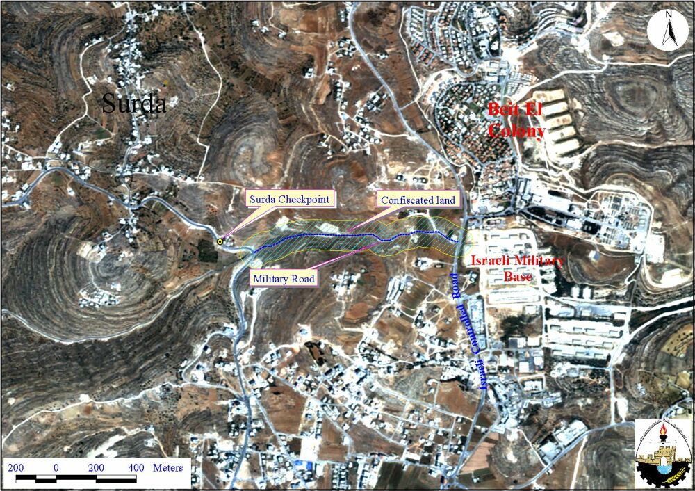
Israeli army has exclusively used the road during the past two years since it connects the Israeli military base of '' Beit El'' with the Israeli checkpoint of Surda; in the road between Ramallah and Beir Zeit. See satellite image.  

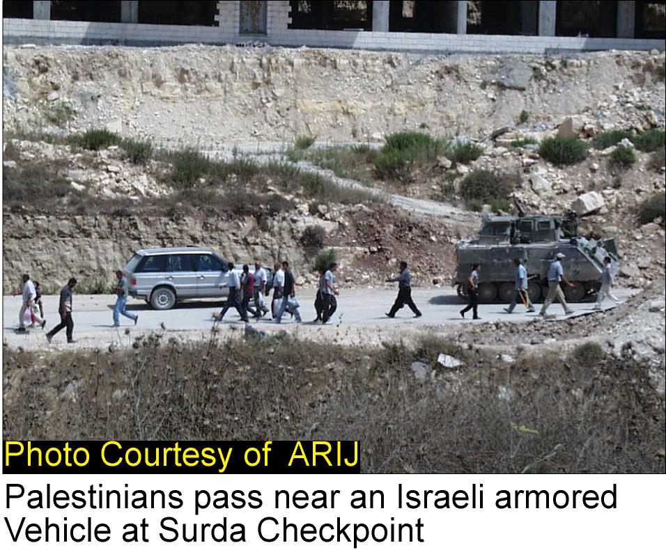
In the mean time, Palestinians were prevented to use the road and thus directed by force to go through the Israeli checkpoints of Surda and Beit El. See photo 1

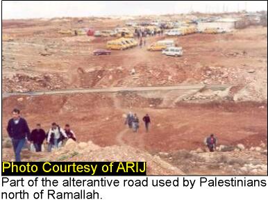
However, the harsh measures and the long delay that people face at Israeli checkpoints, forced ordinary Palestinians to use alternative roads which are – most of the time- inconvenient, muddy and not safe to travel through. Palestinian passengers traveling to their villages and to the northern part of the West Bank used to go on foot through the agricultural lands alongside the road in order to by-pass the checkpoints of Surda and Beit El. See Photo 2.

The Israeli policy of land confiscation to create a security zone has always been a major threat to Palestinian farmers. Based on satellite image analysis, about 80.6 Km2 of agricultural land will be seized by this military order. Besides the road which is 1067 meters long, a suspected   buffer zone of about 75 meters on both sides of the road will further lead to more confiscation of agricultural land.

The seizure and closing of the agricultural land alongside the road will further exacerbate the daily suffering of Palestinian people at Israeli checkpoints of Surda and Beit El as well as it will strengthen  the northern  siege around Ramallah district. See Photo 3


Prepared by:
The Applied Research Institute – Jerusalem


Recommended For You

تهويد صامت بالأمتار: الطريق إلى بني كيديم خطوة نحو الشرعنة الاستيطانية

by arij
July 16, 2025
0
تهويد صامت بالأمتار: الطريق إلى بني كيديم خطوة نحو الشرعنة الاستيطانية

في الثامن عشر من شهر حزيران من العام 2025، تسلّم أهالي بلدتي سعير والشيوخ الواقعتين شمال شرق محافظة الخليل أمراً عسكرياً إسرائيلياً جديداً يقضي بمصادرة 4.8 دونما من...

Read moreDetails

من غير شرعية إلى واقع مفروض, البؤرة الاستيطانية سدي بوعز في رعاية الاحتلال

by arij
July 15, 2025
0

في الثامن من شهر تموز من العام 2025، سلّمت سلطات الاحتلال الإسرائيلي أمرًا عسكريًا جديدًا يقضي بمصادرة أراضٍ فلسطينية وممتلكات خاصة في بلدة الخضر جنوب غرب محافظة بيت...

Read moreDetails

ملاخي هشالوم: أكثر من مجرد بؤرة استيطانية … مشروع تهويد وتوسّع اسرائيلي

by arij
July 10, 2025
0
ملاخي هشالوم: أكثر من مجرد بؤرة استيطانية … مشروع تهويد وتوسّع اسرائيلي

قامت سلطات الاحتلال الإسرائيلي بتاريخ 7 تموز 2025 بنشر أمر عسكري جديد في الضفة الغربية المحتلة، يحمل عنوان: "أمر بشأن الأملاك الحكومية (يهودا والسامرة) (رقم 59) لسنة 1967"....

Read moreDetails

Israeli Order Targets Zububa Village Under Security Claims

by arij
June 24, 2025
0
أمر عسكري إسرائيلي يستهدف أراضي قرية زبوبا الفلسطينية لأغراض أمنية مستعجلة

As part of Israel's systematic violations against Palestinian land in the occupied West Bank", the Israeli occupation authorities, on June 14, 2025, issued a new military order to...

Read moreDetails

أمر عسكري إسرائيلي يستهدف أراضي قرية زبوبا الفلسطينية لأغراض أمنية مستعجلة

by arij
June 21, 2025
0
أمر عسكري إسرائيلي يستهدف أراضي قرية زبوبا الفلسطينية لأغراض أمنية مستعجلة

في خطوة جديدة تُضاف إلى سلسلة الانتهاكات الإسرائيلية بحق الأراضي الفلسطينية في الضفة الغربية المحتلة، سلمت سلطات الاحتلال الإسرائيلي بتاريخ الرابع عشر من حزيران 2025 أهالي قرية زبوبا...

Read moreDetails
Next Post
Israeli settlement activities swallow more land from Nahhalin Village

Israeli settlement activities swallow more land from Nahhalin Village

LATEST NEWS

Villages and Communities of Masafer Yatta: A Model of the Forced Displacement of Palestinian Communities in Area “C”

Villages and Communities of Masafer Yatta: A Model of the Forced Displacement of Palestinian Communities in Area “C”

by arij
August 2, 2025
0

........................................................

Nu’man Village: A Victim of another Judaization Campaign

Nu’man Village: A Victim of another Judaization Campaign

by arij
August 2, 2025
0

........................................................

في حضرة العنف, “المواطن الفلسطيني بين بندقية المستوطن وجرافة الاستيطان”

في حضرة العنف, “المواطن الفلسطيني بين بندقية المستوطن وجرافة الاستيطان”

by arij
August 4, 2025
0

........................................................

​الطرق الالتفافية الإسرائيلية: “مشنقة مشروع حل الدولتين”

​الطرق الالتفافية الإسرائيلية: “مشنقة مشروع حل الدولتين”

by arij
July 21, 2025
0

........................................................

flag_yellow_lowEU-PfP-Logo

This website has been produced with the assistance of the European Union. The contents of this publication are the sole responsibility of ARIJ & LRC and can in no way be taken to reflect the views of the European Union.

© 2025 Copyright ARIJ . All Rights reserved. .

No Result
View All Result
  • Home
  • Settlements
    • New Israeli Settlements
    • Settlement Expansion
  • Israeli Violations
    • Agriculture
    • Confiscation
    • Demolition
    • Environment
    • Eviction of Palestinians
    • Settlers Attacks
  • Bypass Roads
  • Israeli Plans
  • Segregation
    • Checkpoints
    • Closure
    • Separation Plans
  • Military Orders
  • Reports
    • Daily Report
    • Monthly Report
    • Quarterly Report

© 2025 Copyright ARIJ . All Rights reserved. .