• About The Project
  • Palestine in Century
  • Selected Maps
  • Glossary
  • About ARIJ
  • About LRC
  • By Year
    • Case Studies By Year
    • Daily Report By Year
Wednesday, October 29, 2025
POICA
No Result
View All Result
  • Home
  • Settlements
    • New Israeli Settlements
    • Settlement Expansion
  • Israeli Violations
    • Agriculture
    • Confiscation
    • Demolition
    • Environment
    • Eviction of Palestinians
    • Settlers Attacks
  • Bypass Roads
  • Israeli Plans
  • Segregation
    • Checkpoints
    • Closure
    • Separation Plans
  • Military Orders
  • Reports
    • Daily Report
    • Monthly Report
    • Quarterly Report
No Result
View All Result
POICA
No Result
View All Result

Al-Khas and Al Nu’man villages suffocated by the Israeli colonization

October 1, 2003
in Military Orders
Al-Khas and Al Nu’man villages suffocated by the Israeli colonization


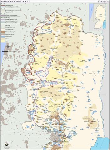
As a continuation to the voluntary transfer policy which is used by the Israelis to force more Palestinians to leave their homeland; residents of Al Khas and Al Nu'man are now facing the expropriation of their fertile agricultural lands at favor of the so called Israeli security 'Envelope of Jerusalem', or the Segregation Wall that isolates Al Nu'man village and cuts off A Khas from its land. See Map of 'Envelope of Jerusalem'.

Implementing de facto policies under the slogans of peace and protection, Israel achieved its colonization activities in Bethlehem district, slicing more lands to construct bypass roads, expand existing settlements and erect the Segregation Wall; thus circumventing the legal system and violating all signed agreements with the PLO.

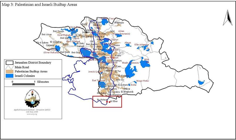
The suffering of the two villages started in the year 1992 when the Israeli municipality of Jerusalem and the Israeli Ministry of Interior prohibited the people from building new houses in the area. The reason was the claim villages' lands to be inside the Israeli redefined borders of the Jerusalem Municipality, in spite of the fact that the inhabitants are holding Palestinian ID's. See map of Jerusalem municipality borders


The IOF worked to depopulate part of the residents by preventing them from building new houses. Such actions obliged a large number of the young couples to leave and build outside the village boundaries claiming that the village didn't exist before the 1967 war, however the following satellite images taken at different times (1967-1987 ) show evidence that the village existed before 1967 the occupation of the Palestinian Territories in 1967. See Satellite image


It can be noticed from the satellite image, the houses colored with blue are those which existed before 1967. For more details, click here  

In July 21, 2003, the Israeli military forces handed residents of Al Khas and Al Nu'man military orders to confiscate 136 dunums of agricultural land to continue the second part of Phase one of the Segregation Wall 'the envelope of Jerusalem'.  

Later on September 16, 2003, the Israeli occupation forces distributed military orders in the Arabic language to residents of Al Nu'man village declaring the confiscation of another 47 dunums of the village's land for military use.  Residents of Al Nu'man village confirmed that their lands were declared as confiscated at favor to construct another part of the Segregation Wall, which will isolate the village and later annex it to Jerusalem municipality borders.

On September 26, 2003, the Israeli occupation forces -IOF- declared the confiscation of 100 dunums of agricultural lands from Al Khas and Al Nu'man villages to construct a new bypass road of '1.2 km length and 160 meters width' alongside the Segregation wall.

The path of the new bypass road will connect Za'atra bypass road, which was constructed earlier in February over Palestinian lands with Al Nu'man village main road, which is considered ''the only exit of the village'', to reach Harhoma Settlement (Abu Ghniem) in the north, to then connect with the south-eastern part of Jerusalem city.  Implementing of this bypass road means that the Israeli authorities are connecting the southeastern settlements of Bethlehem district with Jerusalem to further Israeli strangulation of the district. See map of military orders.


The IOF distributed a number of copies of the military order at night, without pre-warning, notifying the residents of the two villages of the new activities that are going to take place in the area. The residents woke up the next day to find the military orders thrown out in the streets and some others were found on their agricultural lands. The confiscated lands belong to Al Dar'awi family from from Al Nu'man village, Hmiedan family from Al Ta'mra, Bannoura and Qumsieh families from Beit Sahour.

The Israeli activities in the occupied territories cost the Palestinians high prices either by the loss of their land or through the destruction of their private properties.   The encroachment of the Israeli Segregation Wall in the occupied Palestinian villages is a growing danger that threatens the development of Palestinian communities.  Not only does it deprive them of valuable agricultural and grazing lands but it also puts physical barriers to their natural growth and disconnects them from each other.

Related Case studies 

  •  Al-Khas and Al-Nu'man villages between the jaws of occupation
  •  How Palestinians Pay The Price Of Israelâ??s Internal Power Politics
  • The commencement of circulating the orthodox Housing Project in Beit Sahour


Prepared by:  
The Applied Research Institute – Jerusalem


Recommended For You

ما يزيد عن 1900 دونما من الأراضي الفلسطينية في بيت لحم مهددة بالعزل لصالح مستوطنة افراتا

by arij
October 8, 2025
0
ما يزيد عن 1900 دونما من الأراضي الفلسطينية في بيت لحم مهددة بالعزل لصالح مستوطنة افراتا

في الثاني من شهر تشرين أول من العام 2025، أصدرت سلطات الاحتلال الإسرائيلي أمرًا عسكريًا جديدًا يحمل الرقم (ت/3/25) تحت عنوان "تعديل حدود – يهودا والسامرة، 5785-2025". ويأتي...

Read moreDetails

سلطات الاحتلال الإسرائيلي تستغل ‘المنفعة العامة’ لنهب الموارد الفلسطينية

by arij
September 30, 2025
0
سلطات الاحتلال الإسرائيلي تستغل ‘المنفعة العامة’ لنهب الموارد الفلسطينية

في الاول من شهر ايلول من العام 2025، نشرت الإدارة المدنية الإسرائيلية، الذراع الأيمن لحكومة الاحتلال الإسرائيلي أمرا عسكريا جديدا تحت عنوان " أمر ءبشأن قانون الأراضي (الاستملاك...

Read moreDetails

The Occupation Targets the Village of Raba Southeast of Jenin with Military Orders and Seizes Vast Areas of Its Lands

by arij
September 13, 2025
0
الاحتلال يستهدف بأوامر عسكرية قرية رابا جنوب شرق جنين ويصادر مساحات واسعة من أراضيها

 The Israeli occupation Army have continued their policy of plundering Palestinian lands, as their bulldozers leveled wide areas of agricultural land in the village of Raba, southeast of...

Read moreDetails

الاحتلال يستهدف بأوامر عسكرية قرية رابا جنوب شرق جنين ويصادر مساحات واسعة من أراضيها

by arij
September 13, 2025
0
الاحتلال يستهدف بأوامر عسكرية قرية رابا جنوب شرق جنين ويصادر مساحات واسعة من أراضيها

  واصلت قوات الاحتلال الإسرائيلي سياسة نهب الأراضي الفلسطينية، حيث أقدمت آلياتها على تجريف أراض زراعية واسعة في قرية رابا جنوب شرق محافظة جنين، تمهيدا لشق شارع عسكري...

Read moreDetails

Nablus Governorate’s Archaeological Sites Face Israeli Expropriation Plans

by arij
September 11, 2025
0
” المواقع الأثرية في محافظة نابلس… ساحة مفتوحة أمام مخططات المصادرة الإسرائيلية “

On 10 August, 2025, the Israeli Civil Administration (ICA), issued a booklet of military orders signed by the head of the so-called ‘Israeli Civil Administration’ in the occupied...

Read moreDetails
Next Post
Jayyous village: a story of human suffering

Jayyous village: a story of human suffering

LATEST NEWS

الدورة الشتوية للكنيست الإسرائيلي 2025: الضم كسلاح سياسي وإقليمي

by arij
October 25, 2025
0

........................................................

The Israeli Knesset Winter Session 2025: Annexation as a Political and Territorial Weapon

by arij
October 25, 2025
0

........................................................

Annexation of the Jordan Valley: Implications for the Two-State Solution and Regional Stability

الرئاسة الثانية لترامب: فرصة متجددة لطموحات إسرائيل التوسعية – ضم غور الأردن والتداعيات على حل الدولتين واستقرار المنطقة

by arij
October 14, 2025
0

........................................................

محافظة أريحا على خريطة المصادرة الإسرائيلية- إسرائيل تسعى للاستحواذ على أكثر من 7000 دونم في منطقة النبي موسى

محافظة أريحا على خريطة المصادرة الإسرائيلية- إسرائيل تسعى للاستحواذ على أكثر من 7000 دونم في منطقة النبي موسى

by arij
October 13, 2025
0

........................................................

flag_yellow_lowEU-PfP-Logo

This website and its content were initiated in 1993 by the Applied Research Institute – Jerusalem (ARIJ) and the Land Research Center (LRC) with the support from the European Union up until 2023. Since then, the Applied Research Institute – Jerusalem (ARIJ) has taken over the continued development and maintenance of the website. The views expressed remain solely those of ARIJ) and do not necessarily reflect those of the European Union.

© 2025 Copyright ARIJ . All Rights reserved. .

No Result
View All Result
  • Home
  • Settlements
    • New Israeli Settlements
    • Settlement Expansion
  • Israeli Violations
    • Agriculture
    • Confiscation
    • Demolition
    • Environment
    • Eviction of Palestinians
    • Settlers Attacks
  • Bypass Roads
  • Israeli Plans
  • Segregation
    • Checkpoints
    • Closure
    • Separation Plans
  • Military Orders
  • Reports
    • Daily Report
    • Monthly Report
    • Quarterly Report

© 2025 Copyright ARIJ . All Rights reserved. .